#disastermapping search results

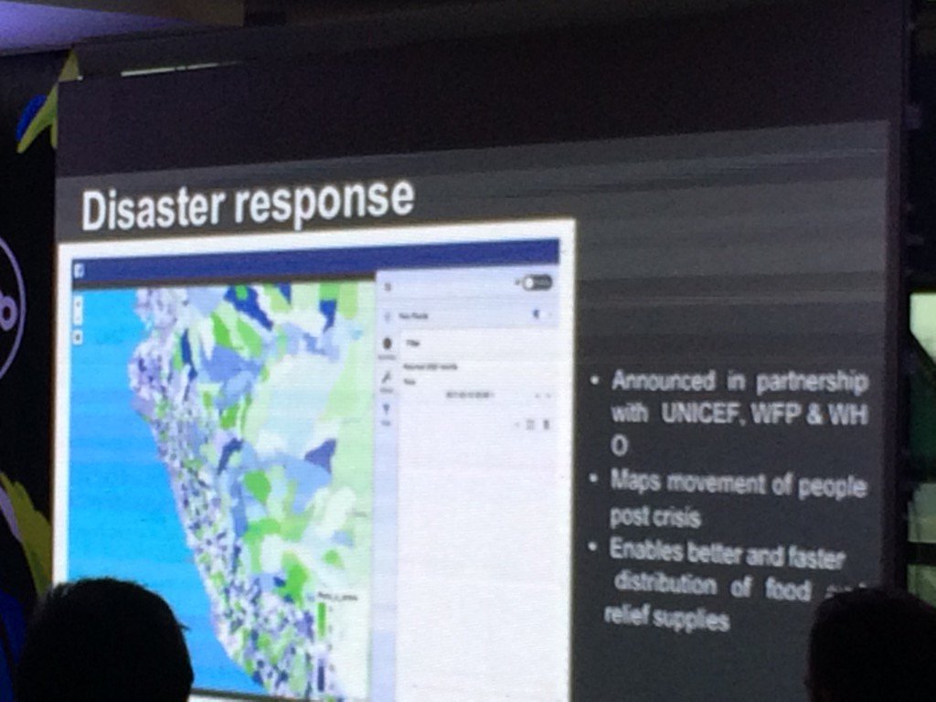
Facebook using data #disastermapping to provide timely sending of relief aid. Data updated every 90min #opencellular

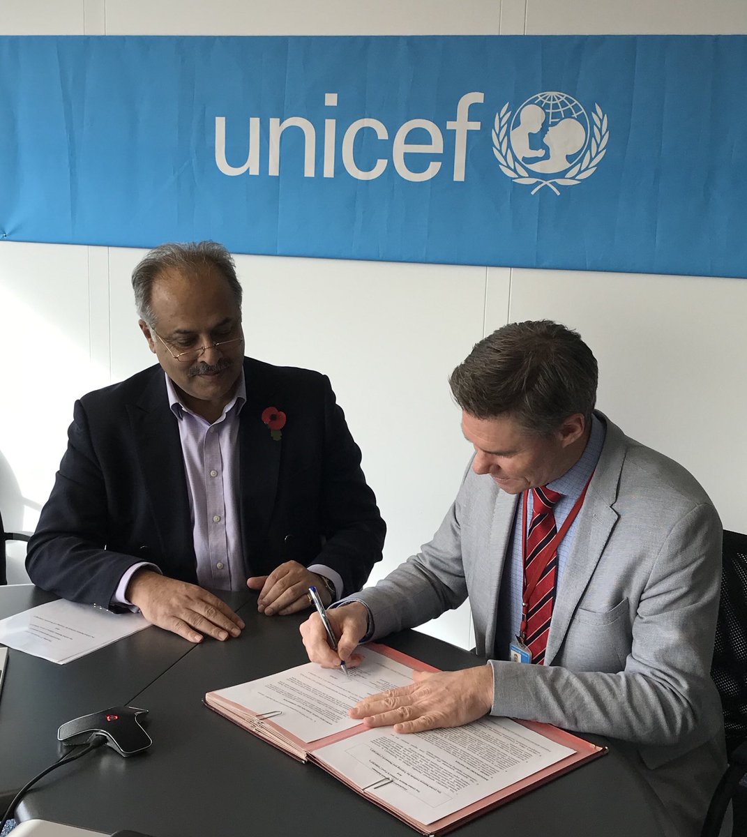
@UNITAR signed Cooperation Agreement with @UNICEF today. #disastermapping #training #EO4SDGs #drr @UNICEFEMOPS @UNICEFinnovate @UNGeneva


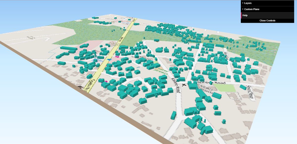
3D view of part of Katoogo, Ggaba, Kampala. #DisasterMapping #MappingForResilience. @hotosm_uganda @geogecko

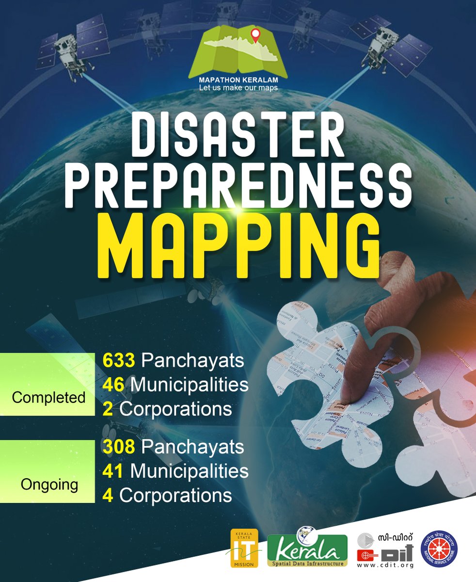
Mapathon Disaster Preparedness Mapping Statistics 🙂 #mapathon #mapathonkerala #disastermapping @_DigitalIndia @CMOKerala @kerala_it @cditofficial @HQ_DG_NCC

#DisasterMapping update on #Cyclone #Elsa approaching #Cuba and heading to #Florida. 10% of populated areas exposed to #hurricane has 0 objects in #OSM. Go to Disaster Ninja and use ✏️ tool to help map homes for 13.5 million people in the region. disaster.ninja/live/#id=e4708… #gischat


Cool stuffs....follow #IW2018 @HDIFtz startups making real change/impacts @RamaniHuria now presenting digital community mapping tools. #IW2018 @WBTanzania #Disastermapping #floodingmapping @wef @Theinspireproj3


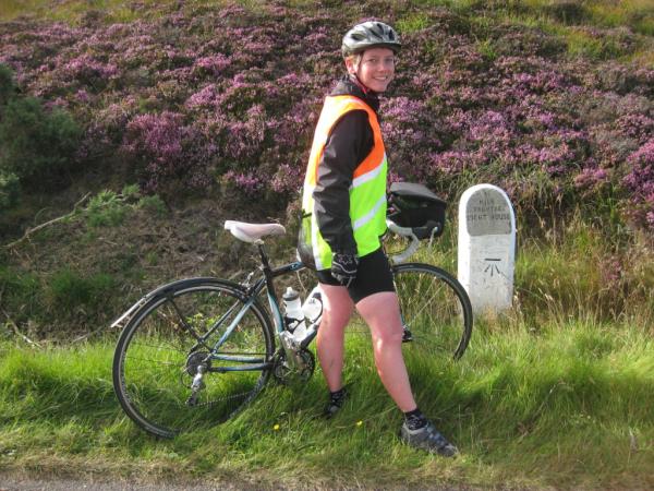
@Chris_AGI Come & join us on our 10 years of disaster mapping bike ride - bit.ly/Hkh8Ir - #disastermapping
🏙️ What happens if high-rise buildings in Central Jakarta collapse in a major quake? Using OpenStreetMap data, we mapped how many surrounding buildings could be directly or indirectly affected. #DisasterMapping #OSMIndonesia #EarthquakeScenario


@bcsweb @RGS_IBGschools @esriuk @mapaction Double whammy of BCS Restless Earth today-girls v boys #cartography #gcse #disastermapping


#Geography #disastermapping Really good interview on @bbcworldservice with another Alice G from @mapaction regarding how they’re helping on the ground in Turkey. mapaction.org/live-mapaction… #geographyteacher


British Cartographic Society Organises Restless Earth Workshops for Schools gim-international.com/content/news/b… #maps #disastermapping #cartography #highimpactlearning


🌍🚀 Exciting news! The European Space Agency is leveraging AI to enhance satellite-based disaster mapping! 🌌 Let's harness tech for a safer planet. Together, we can make a difference! 🌟 #DisasterMapping #AI #SpaceInnovation #ESA #TechForGood
Quick demo of a #Wikidata-based map of @hotosm tasks, colour coded by task focus, based on a new dedicated property, wikidata.org/wiki/Property:… . commons.wikimedia.org/wiki/File:Init… #disastermapping

In the 2nd @fig_young session @EsriUC we will dive into #disastermapping. Christina Boggs, Engineering Geologist @CAgovernment + key leader @URISA and @WomeninGIS, will present on putting your #mappingskills to good use #savedbyasurveyor @hotosm bit.ly/2NqiUOz @FIG_NEWS


No prior experience is required. Here are some resources that you can use to start: 1️⃣ Basic video on how to map: youtube.com/watch?v=Ir-3K0… 2️⃣ Review Learn OSM: learnosm.org/en/ 3️⃣ Join HOT's slack channels for #disastermapping and #mappersupport: slack.hotosm.org
youtube.com
YouTube
Learn How To Map in OpenStreetMap

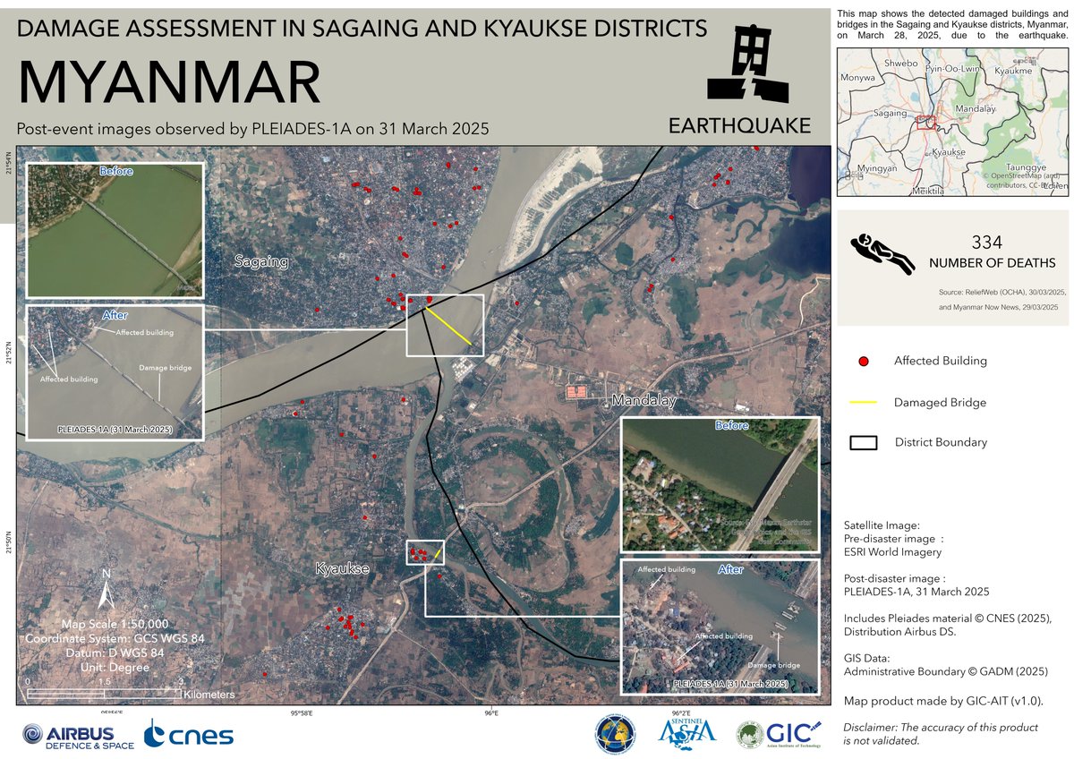
🚨M7.7 earthquake hit near Mandalay, Myanmar on Mar 28, 2025. Tremors reached as far as Bangkok. 📍GIC released satellite-based damage maps for Sagaing & Kyaukse using ESRI & PLEIADES-1A imagery to assess impact. #MyanmarEarthquake #Disastermapping 🔗geoinfo.ait.ac.th/myanmar-earthq…

📣 August's Mappy Hour presentation is available here: buff.ly/3sS7w7n #MappyHour #disasterresilience #disastermapping #OpenStreetMap #OpenStreetMapUS


#GeoTech: Video – Turkey-Syria Earthquake: See How Advanced Mapping Tech Could Aid Rescuers bit.ly/3HW2vyx #disastermapping #geotech #mapping #tools


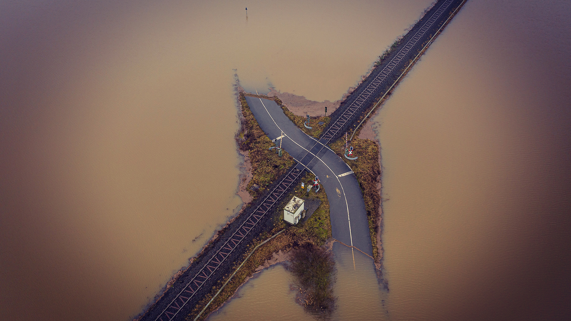
🚨 The latest imagery of Typhoon Kalmaegi captured on the 9th of Nov. Interactive map 👉: soaratlas.com/maps/139809?po… Major flooding is visible across the coastal region, with a distinct brown plume stretching from river to ocean. #TyphoonKalmaegi #DisasterMapping #RemoteSensing
🇳🇵GIC organised training on "Glacial Lake Outburst Flood (GLOF) Mapping using Earth Observation Satellite Data" alongwith DHM in Kathmandu, Nepal on 29-31 July 2025 under the @asiasentinel Project. #Disastermapping #Sentinelasia #JAXA 🔗geoinfo.ait.ac.th/sa-nepal-2025/

Emergency-mapping platforms fuse high-resolution disaster images with GIS layers to guide relief agencies in identifying impassable roads and damaged bridges. #DisasterMapping #GIS

Through the use of satellite imagery and geographic information systems (GIS), the Cook Islands is improving its disaster mapping and planning, ensuring more accurate and informed decision-making. #DisasterMapping #GIS

Honduras is working with international organizations to improve disaster risk mapping and develop strategies for minimizing the impact of hurricanes and floods. #DisasterMapping #GlobalPartnerships

The government is promoting the use of technology, including drones and satellite imagery, to better predict and assess disaster risks and monitor the effectiveness of responses. #TechInDisasterResponse #DisasterMapping

Guinea-Bissau is working on mapping disaster risks and creating geographic information systems (GIS) to better assess and monitor areas at risk. #DisasterMapping #GIS
🏙️ What happens if high-rise buildings in Central Jakarta collapse in a major quake? Using OpenStreetMap data, we mapped how many surrounding buildings could be directly or indirectly affected. #DisasterMapping #OSMIndonesia #EarthquakeScenario
🚨M7.7 earthquake hit near Mandalay, Myanmar on Mar 28, 2025. Tremors reached as far as Bangkok. 📍GIC released satellite-based damage maps for Sagaing & Kyaukse using ESRI & PLEIADES-1A imagery to assess impact. #MyanmarEarthquake #Disastermapping 🔗geoinfo.ait.ac.th/myanmar-earthq…

1/ **Real-Time Disaster Mapping Tools 🗺️🚨** Innovations in mapping technology allow for real-time monitoring and visualization of disaster scenarios, helping agencies coordinate response efforts more effectively! #DisasterMapping #CrisisManagement
Did you know that our website has recorded talks on lots of topics? We're sharing disaster mapping presentations in recognition of #National Preparedness Month. Check it out: buff.ly/3WmAPLj #OpenStreetMap #disastermapping #mapping


Watch and learn how South Africa Flying Labs is responding to devastating floods with drones bit.ly/3PfIyXJ #DisasterMapping #DisasterResponse #DisasterManagement
youtube.com
YouTube
Turning Data into Action: South Africa Flying Labs Responding to...

Artificial Intelligence and Machine Learning can improve disaster mapping and management but this increased reliance requires a higher level of authentication and tracing to protect information. #DisasterMapping #AI Click below to discover more⬇️ bit.ly/3ZHP1yL


@UNITAR signed Cooperation Agreement with @UNICEF today. #disastermapping #training #EO4SDGs #drr @UNICEFEMOPS @UNICEFinnovate @UNGeneva
3D view of part of Katoogo, Ggaba, Kampala. #DisasterMapping #MappingForResilience. @hotosm_uganda @geogecko
@Chris_AGI Come & join us on our 10 years of disaster mapping bike ride - bit.ly/Hkh8Ir - #disastermapping
British Cartographic Society Organises Restless Earth Workshops for Schools gim-international.com/content/news/b… #maps #disastermapping #cartography #highimpactlearning
Mapathon Disaster Preparedness Mapping Statistics 🙂 #mapathon #mapathonkerala #disastermapping @_DigitalIndia @CMOKerala @kerala_it @cditofficial @HQ_DG_NCC
Cool stuffs....follow #IW2018 @HDIFtz startups making real change/impacts @RamaniHuria now presenting digital community mapping tools. #IW2018 @WBTanzania #Disastermapping #floodingmapping @wef @Theinspireproj3
#DisasterMapping update on #Cyclone #Elsa approaching #Cuba and heading to #Florida. 10% of populated areas exposed to #hurricane has 0 objects in #OSM. Go to Disaster Ninja and use ✏️ tool to help map homes for 13.5 million people in the region. disaster.ninja/live/#id=e4708… #gischat
Facebook using data #disastermapping to provide timely sending of relief aid. Data updated every 90min #opencellular
In the 2nd @fig_young session @EsriUC we will dive into #disastermapping. Christina Boggs, Engineering Geologist @CAgovernment + key leader @URISA and @WomeninGIS, will present on putting your #mappingskills to good use #savedbyasurveyor @hotosm bit.ly/2NqiUOz @FIG_NEWS
📣 August's Mappy Hour presentation is available here: buff.ly/3sS7w7n #MappyHour #disasterresilience #disastermapping #OpenStreetMap #OpenStreetMapUS
🏙️ What happens if high-rise buildings in Central Jakarta collapse in a major quake? Using OpenStreetMap data, we mapped how many surrounding buildings could be directly or indirectly affected. #DisasterMapping #OSMIndonesia #EarthquakeScenario
@bcsweb @RGS_IBGschools @esriuk @mapaction Double whammy of BCS Restless Earth today-girls v boys #cartography #gcse #disastermapping
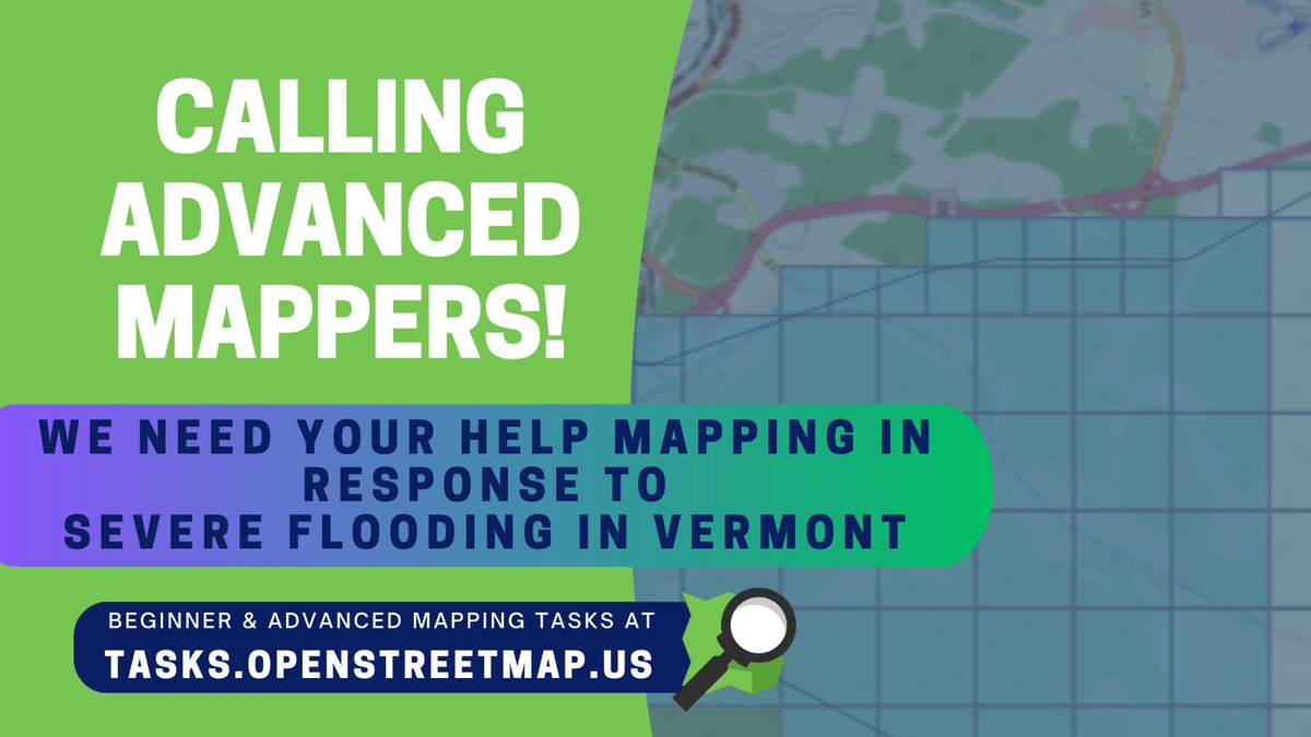
Calling advanced mappers! Help us map Vermont roads and waterways affected by severe flooding: tasks.openstreetmap.us/projects/430 #OpenStreetMap #volunteers #disastermapping #Vermontflooding #Vermontfloods
#GeoTech: Video – Turkey-Syria Earthquake: See How Advanced Mapping Tech Could Aid Rescuers bit.ly/3HW2vyx #disastermapping #geotech #mapping #tools

How Facebook’s data can be used for good in mapping population numbers in natural disasters dlvr.it/RN9XSn #DirectRelief #Disastermapping #FacebookAustralia

Did you know that our website has recorded talks on lots of topics? We're sharing disaster mapping presentations in recognition of #National Preparedness Month. Check it out: buff.ly/3WmAPLj #OpenStreetMap #disastermapping #mapping

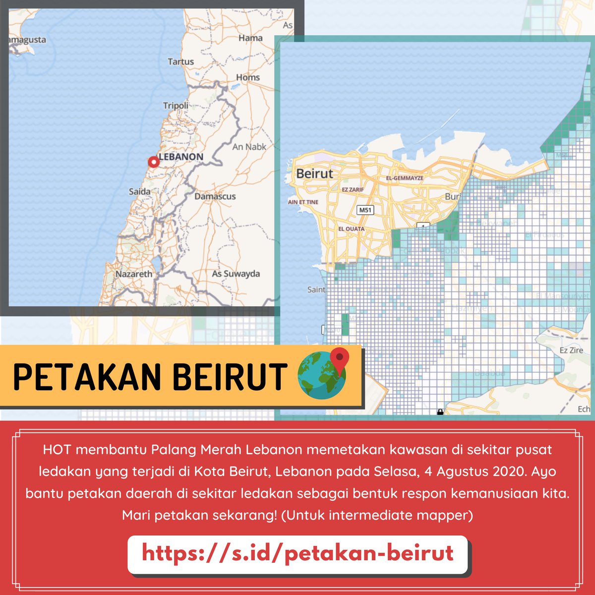
❗Calls for Humanitarian Action HOT supporting the @RedCrossLebanon in response to the #BeirutBlast by mapping an extended area around central #Beirut. Help us map Beirut: 🌏s.id/petakan-beirut P.S: This is for intermediate mappers. #disastermapping #Beirut
🚨M7.7 earthquake hit near Mandalay, Myanmar on Mar 28, 2025. Tremors reached as far as Bangkok. 📍GIC released satellite-based damage maps for Sagaing & Kyaukse using ESRI & PLEIADES-1A imagery to assess impact. #MyanmarEarthquake #Disastermapping 🔗geoinfo.ait.ac.th/myanmar-earthq…
#Geography #disastermapping Really good interview on @bbcworldservice with another Alice G from @mapaction regarding how they’re helping on the ground in Turkey. mapaction.org/live-mapaction… #geographyteacher
Something went wrong.
Something went wrong.
United States Trends
- 1. #WWERaw 64.4K posts
- 2. Purdy 26.4K posts
- 3. Panthers 36.1K posts
- 4. Bryce 19.8K posts
- 5. 49ers 38.4K posts
- 6. Canales 13.3K posts
- 7. Gonzaga 3,209 posts
- 8. #FTTB 5,414 posts
- 9. Mac Jones 4,775 posts
- 10. Penta 9,742 posts
- 11. #KeepPounding 5,265 posts
- 12. Niners 5,498 posts
- 13. Gunther 14.2K posts
- 14. Jennings 8,498 posts
- 15. Jaycee Horn 2,660 posts
- 16. Zags N/A
- 17. Amen Thompson 1,051 posts
- 18. Logan Cooley N/A
- 19. Moehrig N/A
- 20. #RawOnNetflix 2,111 posts