#openmaptiles search results


#OpenMapTiles version 3.13 has been released with improvements for showing routes on your maps. You can highlight toll roads, use multiple labels for highways, mark out private roads with no access, and much more. Check out what has been improved here: maptiler.link/3BkPDy2.

Design the #OpenStreetMap with various styling languages using #OpenMapTiles. Read more at maptiler.com/blog/2018/05/o… #OSM #vectortiles #opensource #opendata

La beauté de la carte de Cassini en version vectorielle? oui, @fre2d l'a fait - makinacorpus.github.io/cassini-gl-sty… - et voyez comment ici makina-corpus.com/blog/metier/20… #VectorTiles #OpenMapTiles #MapboxGL #BaseMaps #OpenStreetMap @OSM_FR #Cartographie


@geowolf working on better #mbstyles support in #geoserver together with support for #openmaptiles source data. @foss4g @OSGeo #foss4g @opengeospatial #gis


#OpenMapTiles 3.12 keep up with changes in #OSM. New tagging of protected areas as boundary=protected_area is now rendered as part of the park layer. Read other news at maptiler.link/3qvNEkb

More accurate towns and villages 🏘️ on zoom level 13. The brand-new algorithm generalizes buildings into blocks. Read what is new in #OpenMapTiles 3.12 at maptiler.link/3qvNEkb
New types of water bodies added to the water layer in #OpenMapTiles 3.12. Read more details at maptiler.link/3qvNEkb
Big thanks to #OpenMapTiles 3.12 contributors involved over a long period. @nyuriks @xurxosanz @fre2d @smellman @janphilipp_bnck and others: maptiler.link/3j7LHd7 Support our amazing #opensource community with like, follow, or join it as a contributor: maptiler.link/3gRuwJP

Meet our team at the #FOSS4G workshop and learn how to build a geospatial application using #opensource tools as #OpenMapTiles, #MapLibre GL JS, & #MapLibre Native, #QGIS. The last seats are available. Register at callforpapers.2021.foss4g.org/foss4g-2021-wo…

Don’t miss out MapTiler at #FOSS4G 2021: Join us to learn about updates on #OpenMapTiles, MapTiler #QGIS plugin, and @MapLibre - #opensource tools we are happy to build to help people to create their map apps.


Jiri is talking about recent development of #openMapTiles @MapTiler #sotm2019 #github #opensource #openstreetmap


Highlighting a country's borders is a simple task with new tags in #OpenMapTiles 3.12. Read more at maptiler.link/3yWfuei

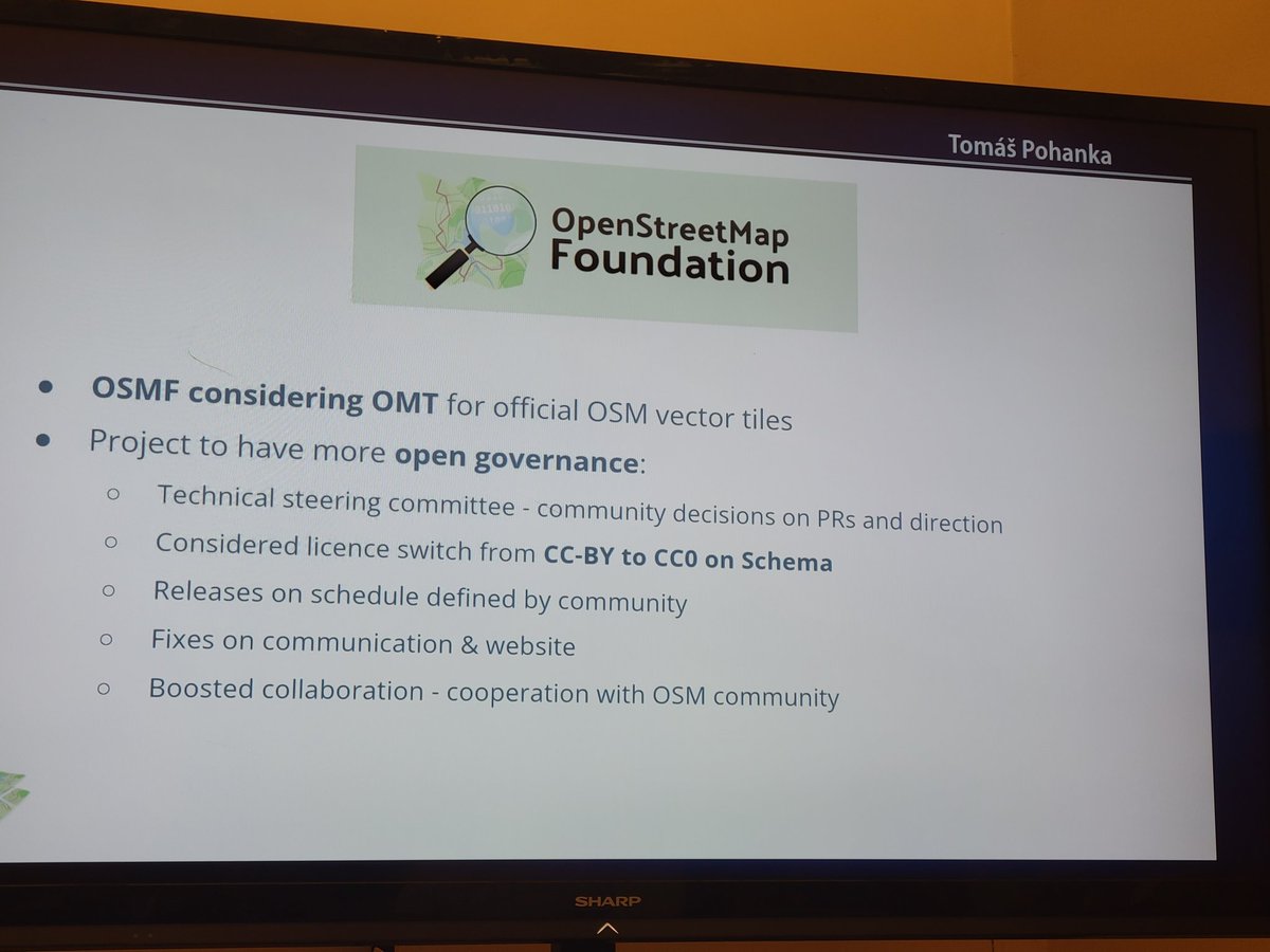
If you want #OpenStreetMap style vector tiles for your #maps, go to @TomPohanka's talk @foss4g about @OpenMapTiles! 15:00 UBT F / N212 - Floor 3 Details here: maptiler.link/46u4fu7 #OpenMapTiles #foss4g2023

Airports with more precious maps in #OpenMapTiles 3.12. Gates and more information related to airfields added to 🛬 Charles-de-Gaulle airports (#CDG) and others. Read more at maptiler.link/3qvNEkb.


How the @washingtonpost is replacing Mapbox with open source solutions. By @kevinschaul #nopebox #slippymaps @protomaps #OpenMapTiles @maplibre @maputnik kschaul.com/post/2023/02/1…

Are you attending @sotm in Heidelberg? Visit our talk on Monday at 15:00 in HSO room and learn about OpenMapTiles which makes it possible to use a custom coordinate system with #OSM map. See you there ! #OpenMapTiles #SotM #OpenStreetMap

Make a map people can easily understand. The #OpenMapTiles project currently supports 70 languages. The new added are Hindi, Tamil, Telugu, Hiragana Japanese, Romanized Japanese, and Romanized Korean. Read more at maptiler.link/3qvNEkb

I'd like to express my gratitude to #OpenMapTiles and #OpenStreetMap contributors for providing the map data used in this post. Their collaborative effort makes it possible for me to illustrate effectively. Thank you!
Finally, @TomPohanka gave everyone a rundown of the latest developments in #OpenMapTiles: maptiler.link/3MKpLCe Thanks again to the organizers of #FOSS4GEurope and all the attendees; it was a fantastic conference!
youtube.com
YouTube
OSS4GE 2024 | OpenMapTiles - vector tiles from OpenStreetMap &...

qualcuno sa avere a che fare con #openmaptiles ? Ho scritto questa domanda, sarei grato se qualcuno sapesse qualcosa Grazie #openstreetmap #osm community.openstreetmap.org/t/stuck-trying…
Get up-to-date with the latest additions to #OpenMapTiles by watching @TomPohanka's talk from #FOSS4G2023. The video is on @YouTube here: maptiler.link/3RE2G88
If you want #OpenStreetMap style vector tiles for your #maps, go to @TomPohanka's talk @foss4g about @OpenMapTiles! 15:00 UBT F / N212 - Floor 3 Details here: maptiler.link/46u4fu7 #OpenMapTiles #foss4g2023
How the @washingtonpost is replacing Mapbox with open source solutions. By @kevinschaul #nopebox #slippymaps @protomaps #OpenMapTiles @maplibre @maputnik kschaul.com/post/2023/02/1…

Quickly Set Up #OpenStreetMap Tile Server On #Ubuntu with #OpenMapTiles || #Linux OpenSource #JavaScript #WebDev #WebDevelopment bit.ly/3SpVOcs via drumup.io

There are some new data layers in @OpenMapTiles 3.13 including cable car names and ferry route labels like the ones shown here. Learn all about the improvements in the latest release here: maptiler.link/3h2mj6k #osm #maps #OpenMapTiles


OpenMapTilesが新しいバージョンになっている。年末年始にスタイリングをしていて、(特に海外で)気になっていたことが改善されていてとても嬉しい。#OpenMapTiles #maptiler #OpenStreetMap maptiler.com/news/2022/02/o…

#fossgis2022 Mit #OpenMapTiles eigene Karten erzeugen pretalx.com/fossgis2022/ta… fossgis-konferenz.de/2022/anmeldung/ #gis #gischat

Se ha lanzado la versión 3.13 de #OpenMapTiles con mejoras al mostrar rutas en sus mapas. Puedes resaltar carreteras con peaje, utilizar varias etiquetas para autopistas, marcar carreteras privadas sin acceso y mucho más. Vea lo que se ha mejorado aquí: maptiler.link/3BkPDy2.
#OpenMapTiles version 3.13 has been released with improvements for showing routes on your maps. You can highlight toll roads, use multiple labels for highways, mark out private roads with no access, and much more. Check out what has been improved here: maptiler.link/3BkPDy2.
#OpenMapTiles version 3.13 has been released with improvements for showing routes on your maps. You can highlight toll roads, use multiple labels for highways, mark out private roads with no access, and much more. Check out what has been improved here: maptiler.link/3BkPDy2.
OpenMapTiles 3.13 released: github.com/openmaptiles/o… Big thanks to all who contributed! #OpenMapTiles
github.com
Release v3.13 · openmaptiles/openmaptiles
RELEASE 3.13 Big thanks to all contributors, especially @ZeLonewolf, @zstadler, @Falke-Design, @nyurik, @eva-j or @frodrigo to name a few. There are 107 merged pull requests! Schema related Adding...
記事を投稿しました。 「全世界のベクトルタイルOpenMapTilesを使って地図のスタイリングをする」 qiita.com/moritoru/items… #maplibre #mapbox #openmaptiles #maptiler #foss4g
qiita.com
全世界のベクトルタイルOpenMapTilesを使って地図のスタイリングをする - Qiita
はじめに 地図愛好家の皆さんの中には、地図を見ることや使うことに限らず、地図を作ることに魅力を感じる人も多いと思います。私自身はその1人で、OpenStreetMapのごく初期には、当時住んでいた横浜市港南区を自転車で走り回って、iPhone3Gを使って道路を計測してパソ...
#OpenMapTiles 3.8 brings a lot of changes. We improved multi-level crossing, water layer and also other features. Read more at maptiler.com/blog/2018/04/o… #OSM

If you want #OpenStreetMap style vector tiles for your #maps, go to @TomPohanka's talk @foss4g about @OpenMapTiles! 15:00 UBT F / N212 - Floor 3 Details here: maptiler.link/46u4fu7 #OpenMapTiles #foss4g2023
La beauté de la carte de Cassini en version vectorielle? oui, @fre2d l'a fait - makinacorpus.github.io/cassini-gl-sty… - et voyez comment ici makina-corpus.com/blog/metier/20… #VectorTiles #OpenMapTiles #MapboxGL #BaseMaps #OpenStreetMap @OSM_FR #Cartographie
Quickly Set Up #OpenStreetMap Tile Server On #Ubuntu with #OpenMapTiles || #Linux OpenSource #JavaScript #WebDev #WebDevelopment bit.ly/3SpVOcs via drumup.io
@geowolf working on better #mbstyles support in #geoserver together with support for #openmaptiles source data. @foss4g @OSGeo #foss4g @opengeospatial #gis
#OpenMapTiles version 3.13 has been released with improvements for showing routes on your maps. You can highlight toll roads, use multiple labels for highways, mark out private roads with no access, and much more. Check out what has been improved here: maptiler.link/3BkPDy2.
Big thanks to #OpenMapTiles 3.12 contributors involved over a long period. @nyuriks @xurxosanz @fre2d @smellman @janphilipp_bnck and others: maptiler.link/3j7LHd7 Support our amazing #opensource community with like, follow, or join it as a contributor: maptiler.link/3gRuwJP
How the @washingtonpost is replacing Mapbox with open source solutions. By @kevinschaul #nopebox #slippymaps @protomaps #OpenMapTiles @maplibre @maputnik kschaul.com/post/2023/02/1…
@RobChohan is talking at #FOSS4GNA about using #OpenMapTiles for offline mobile apps. See him on Wednesday. Check more info at goo.gl/r3nnXz

Do you want to enhance your map with additional data from #OpenStreetMap? Don't miss our presentation about #OpenMapTiles and possibilities you have with this #opensource project. See you at @SOTM on Saturday at 11:30 am, room S.0.2! #sotm #sotm2018

#OpenMapTiles 3.12 keep up with changes in #OSM. New tagging of protected areas as boundary=protected_area is now rendered as part of the park layer. Read other news at maptiler.link/3qvNEkb
New types of water bodies added to the water layer in #OpenMapTiles 3.12. Read more details at maptiler.link/3qvNEkb
Meet our team at the #FOSS4G workshop and learn how to build a geospatial application using #opensource tools as #OpenMapTiles, #MapLibre GL JS, & #MapLibre Native, #QGIS. The last seats are available. Register at callforpapers.2021.foss4g.org/foss4g-2021-wo…
Don’t miss out MapTiler at #FOSS4G 2021: Join us to learn about updates on #OpenMapTiles, MapTiler #QGIS plugin, and @MapLibre - #opensource tools we are happy to build to help people to create their map apps.
Jiri is talking about recent development of #openMapTiles @MapTiler #sotm2019 #github #opensource #openstreetmap

Top story: @geosolutions_it: '@geowolf working on better #mbstyles support in #geoserver together with support for #openmaptiles source data. @foss4g @OSGeo #foss4g @opengeospatial #gis ' https://t.co/qdxQJzktcq, see more tweetedtimes.com/v/1525?s=tnp
More accurate towns and villages 🏘️ on zoom level 13. The brand-new algorithm generalizes buildings into blocks. Read what is new in #OpenMapTiles 3.12 at maptiler.link/3qvNEkb
There are some new data layers in @OpenMapTiles 3.13 including cable car names and ferry route labels like the ones shown here. Learn all about the improvements in the latest release here: maptiler.link/3h2mj6k #osm #maps #OpenMapTiles
Something went wrong.
Something went wrong.
United States Trends
- 1. Veterans Day 361K posts
- 2. Woody 11.6K posts
- 3. Toy Story 5 14.4K posts
- 4. Nico 141K posts
- 5. Luka 83.5K posts
- 6. Gambit 40.2K posts
- 7. Travis Hunter 3,511 posts
- 8. Payne 11.9K posts
- 9. Mavs 32.5K posts
- 10. Vets 32.2K posts
- 11. Sabonis 3,653 posts
- 12. Pat McAfee 5,163 posts
- 13. #JonatanVendeHumo 3,425 posts
- 14. Wike 113K posts
- 15. Jonatan Palacios 2,200 posts
- 16. Battlenet 3,529 posts
- 17. SBMM 1,272 posts
- 18. Jay Rock 3,755 posts
- 19. Kyrie 7,776 posts
- 20. Antifa 186K posts