#spatialreference search results

A #MapProjection is set up and a #SpatialReference is defined for #EsriUC next week. 3 workshops, Hand-On Learning Lab prepared a special lesson and #MapProjection Engine team will be available at Spatial Analysis & Data Science island all 3 days. Join us. #EsriUC2019 #2019EsriUC

A #MapProjection is set up and a #SpatialReference is defined for #DevSummit next week. Join Projection Engine team on Thursday...

A #MapProjection is set up and a #SpatialReference is defined for #DevSummit next week. Join Rob and me on Friday morning...

Do you have questions about #MapProjections, #SpatialReference, coordinate systems, transformations? Look for #MapProjection Engine team at Spatial Analytics Expo island. #EsriUC #EsriUC2018 #2018EsriUC
A #MapProjection is set up and a #SpatialReference is defined for #EsriUC next week. Here is the list of workshops about coordinate systems, transformations, reference frames, and #mapprojections. Join us on Wednesday and Thursday. #EsriUC2018 #2018EsriUC

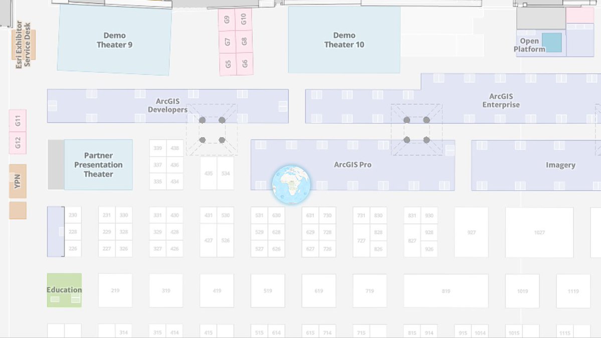
A #MapProjection is set and a #SpatialReference is defined for #EsriUC2024 next week. Don’t forget to check @EsriUC agenda. We prepared three talks related to coordinate systems. The #MapProjection Engine team will be available at @ArcGISPro showcase expo all 3 days. Join us. 🌐

A #MapProjection is set up and a #SpatialReference is defined for @Esri #DevSummit next week. Join us for talks about #MapProjections, coordinate systems, and transformations throughout the week.

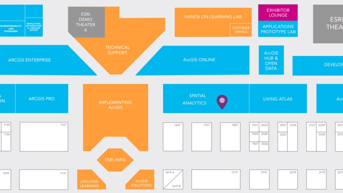
After great @EsriUC Plenary yesterday, it is time for @Esri Showcase Expo. If you have questions about coordinate systems, transformations, #MapProjections, #SpatialReference, look for #MapProjection Engine team at @ArcGISPro Coordinate Systems Expo island. #EsriUC #EsriUC2023
After great @EsriUC Plenary yesterday, it is time for @Esri Showcase Expo. If you have questions about coordinate systems, transformations, #MapProjections, #SpatialReference, look for #MapProjection Engine team at @ArcGISPro Coordinate Systems Expo island. #EsriUC #EsriUC2022


EPSG-Codes: Den Überblick behalten! / EPSG codes: Keep the overview! geoobserver.wordpress.com/2024/03/20/eps… #epsg #spatialreference #gistribe #gischat #fossgis #foss4g #OSGeo #spatial #geospatial #gis #geo #geoObserver pls RT

Site Information Updated: #spatialreference.org - siterank.today/siteinfo/spati…

#spatialreference.org you are temporarily unavailable. Here I though I was the sole creator of 503 errors!

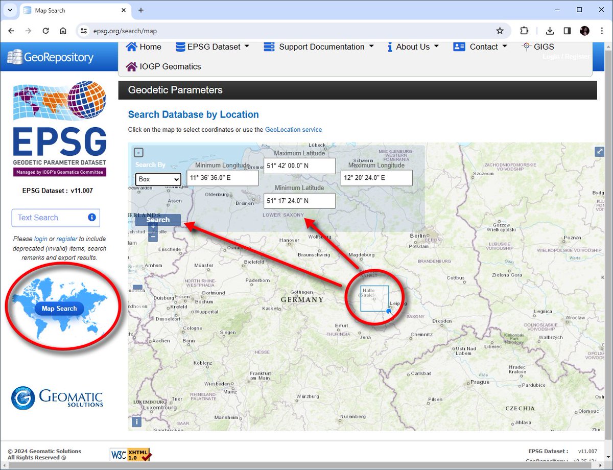
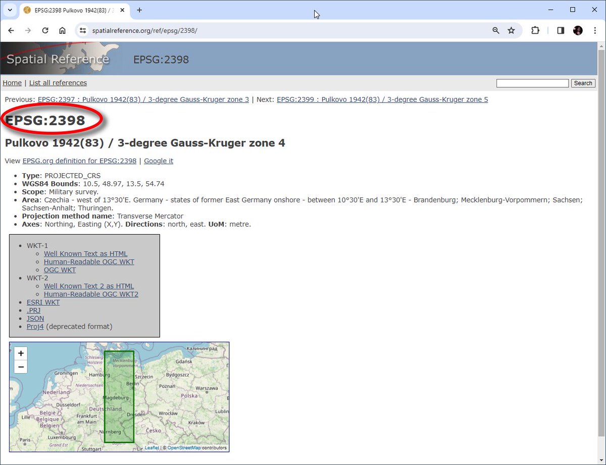
would like to know how #spatialreference dot org is able to display a bbox where the SRS is valid. See eg http://j.mp/ovZhGh

Its time we stop worrying about projection on the fly & time we start storing data in a coordinate system that makes sense #SpatialReference
Heads up... US is moving from static #SpatialReference systems in 2022 esri.com/about/newsroom…
Spatial Reference is null in ESRI Silverlight Map http://ur.ly/Gajg #spatialreference

Finland Uniform Coordinate System at #spatialreference http://bit.ly/d7Jims thanks to @jlehtoma (converting incoming GPS in #earthcape )

#9horizonsbrewingco #SpatialReference #ipa, kettle and dry hopped with massive amount of #mosaic… instagram.com/p/BH0bHwsD6hM/
Dynamic Coordinate Reference Systems #spatialreference #GDA2020 #GDA94 #WGS84 #WGS1984 #ITRF2014 #mapprojectionsarehard #mapprojection #mapprojections #GIS youtube.com/watch?v=IKM-bR…

youtube.com
YouTube
Dynamic Coordinate Reference Systems
After great @EsriUC Plenary yesterday, it is time for @Esri Showcase Expo. If you have questions about coordinate systems, transformations, #MapProjections, #SpatialReference, look for #MapProjection Engine team at @ArcGISPro Coordinate Systems Expo kiosk. 🌐 #EsriUC #EsriUC2024

A #MapProjection is set and a #SpatialReference is defined for #EsriUC2024 next week. Don’t forget to check @EsriUC agenda. We prepared three talks related to coordinate systems. The #MapProjection Engine team will be available at @ArcGISPro showcase expo all 3 days. Join us. 🌐
EPSG-Codes: Den Überblick behalten! / EPSG codes: Keep the overview! geoobserver.wordpress.com/2024/03/20/eps… #epsg #spatialreference #gistribe #gischat #fossgis #foss4g #OSGeo #spatial #geospatial #gis #geo #geoObserver pls RT
After great @EsriUC Plenary yesterday, it is time for @Esri Showcase Expo. If you have questions about coordinate systems, transformations, #MapProjections, #SpatialReference, look for #MapProjection Engine team at @ArcGISPro Coordinate Systems Expo island. #EsriUC #EsriUC2023
A #MapProjection is set and a #SpatialReference is defined for #EsriUC2023 next week. Don’t forget to check @EsriUC agenda. There are two talks related to coordinate systems. The #MapProjection Engine team will be available at @ArcGISPro island all 3 days. Join us.

After great @EsriUC Plenary yesterday, it is time for @Esri Showcase Expo. If you have questions about coordinate systems, transformations, #MapProjections, #SpatialReference, look for #MapProjection Engine team at @ArcGISPro Coordinate Systems Expo island. #EsriUC #EsriUC2022
Dynamic Coordinate Reference Systems #spatialreference #GDA2020 #GDA94 #WGS84 #WGS1984 #ITRF2014 #mapprojectionsarehard #mapprojection #mapprojections #GIS youtube.com/watch?v=IKM-bR…
youtube.com
YouTube
Dynamic Coordinate Reference Systems
Do you have questions about #MapProjections, #SpatialReference, coordinate systems, transformations? Look for #MapProjection Engine team at Spatial Analysis & Data Science Expo island. #EsriUC #EsriUC2019 #2019EsriUC

A #MapProjection is set up and a #SpatialReference is defined for #EsriUC next week. 3 workshops, Hand-On Learning Lab prepared a special lesson and #MapProjection Engine team will be available at Spatial Analysis & Data Science island all 3 days. Join us. #EsriUC2019 #2019EsriUC
A #MapProjection is set up and a #SpatialReference is defined for @Esri #DevSummit next week. Join us for talks about #MapProjections, coordinate systems, and transformations throughout the week.
Heads up... US is moving from static #SpatialReference systems in 2022 esri.com/about/newsroom…
Do you have questions about #MapProjections, #SpatialReference, coordinate systems, transformations? Look for #MapProjection Engine team at Spatial Analytics Expo island. #EsriUC #EsriUC2018 #2018EsriUC
A #MapProjection is set up and a #SpatialReference is defined for #EsriUC next week. Here is the list of workshops about coordinate systems, transformations, reference frames, and #mapprojections. Join us on Wednesday and Thursday. #EsriUC2018 #2018EsriUC
A #MapProjection is set up and a #SpatialReference is defined for #DevSummit next week. Join Projection Engine team on Thursday...
Site Information Updated: #spatialreference.org - siterank.today/siteinfo/spati…
A #MapProjection is set up and a #SpatialReference is defined for #DevSummit next week. Join Rob and me on Friday morning...
#9horizonsbrewingco #SpatialReference #ipa, kettle and dry hopped with massive amount of #mosaic… instagram.com/p/BH0bHwsD6hM/
would like to know how #spatialreference dot org is able to display a bbox where the SRS is valid. See eg http://j.mp/ovZhGh
#spatialreference.org you are temporarily unavailable. Here I though I was the sole creator of 503 errors!
Spatial Reference is null in ESRI Silverlight Map http://ur.ly/Gajg #spatialreference
EPSG-Codes: Den Überblick behalten! / EPSG codes: Keep the overview! geoobserver.wordpress.com/2024/03/20/eps… #epsg #spatialreference #gistribe #gischat #fossgis #foss4g #OSGeo #spatial #geospatial #gis #geo #geoObserver pls RT
A #MapProjection is set up and a #SpatialReference is defined for #EsriUC next week. 3 workshops, Hand-On Learning Lab prepared a special lesson and #MapProjection Engine team will be available at Spatial Analysis & Data Science island all 3 days. Join us. #EsriUC2019 #2019EsriUC
A #MapProjection is set up and a #SpatialReference is defined for #DevSummit next week. Join Projection Engine team on Thursday...
A #MapProjection is set and a #SpatialReference is defined for #EsriUC2024 next week. Don’t forget to check @EsriUC agenda. We prepared three talks related to coordinate systems. The #MapProjection Engine team will be available at @ArcGISPro showcase expo all 3 days. Join us. 🌐
A #MapProjection is set up and a #SpatialReference is defined for #DevSummit next week. Join Rob and me on Friday morning...
After great @EsriUC Plenary yesterday, it is time for @Esri Showcase Expo. If you have questions about coordinate systems, transformations, #MapProjections, #SpatialReference, look for #MapProjection Engine team at @ArcGISPro Coordinate Systems Expo island. #EsriUC #EsriUC2023
Do you have questions about #MapProjections, #SpatialReference, coordinate systems, transformations? Look for #MapProjection Engine team at Spatial Analytics Expo island. #EsriUC #EsriUC2018 #2018EsriUC
A #MapProjection is set up and a #SpatialReference is defined for @Esri #DevSummit next week. Join us for talks about #MapProjections, coordinate systems, and transformations throughout the week.
A #MapProjection is set up and a #SpatialReference is defined for #EsriUC next week. Here is the list of workshops about coordinate systems, transformations, reference frames, and #mapprojections. Join us on Wednesday and Thursday. #EsriUC2018 #2018EsriUC
After great @EsriUC Plenary yesterday, it is time for @Esri Showcase Expo. If you have questions about coordinate systems, transformations, #MapProjections, #SpatialReference, look for #MapProjection Engine team at @ArcGISPro Coordinate Systems Expo island. #EsriUC #EsriUC2022
Something went wrong.
Something went wrong.
United States Trends
- 1. Good Friday 51.6K posts
- 2. #FridayVibes 3,462 posts
- 3. Reagan 66.7K posts
- 4. #CentralAnniversaryxOrm 479K posts
- 5. ORM CENTRAL CHIDLOM ANN 447K posts
- 6. #FridayFeeling 1,785 posts
- 7. #FridayMotivation 2,582 posts
- 8. Aaron Gordon 32K posts
- 9. Finally Friday 5,040 posts
- 10. Chelsea Clinton 8,275 posts
- 11. Steph 73.5K posts
- 12. U-Haul 5,681 posts
- 13. Halle 22.9K posts
- 14. Jokic 24.5K posts
- 15. Oval Office 19.4K posts
- 16. Sven 9,471 posts
- 17. Ontario 64.2K posts
- 18. Lover Girl 35.2K posts
- 19. #EAT_IT_UP_SPAGHETTI 278K posts
- 20. Wentz 26.4K posts