#veryhighresolution search results

Fast #Segmentation and #Classification of #VeryHighResolution #RemoteSensing Data Using #SLIC #Superpixels by Ovidiu Csillik 👉mdpi.com/2072-4292/9/3/… #OBIA #computervision #randomforest #image #MRS #WorldView2


So, Jody, would you prefer we post them in color, or black and white? #VeryHighResolution #DownwardDodger

Check out how #GEOSAT2 is able to show the evolution of #CumbreViejaVolcano over time. Its #VeryHighResolution images enable to visualize the delta growth until its outflow into the sea, as well as the changes in the lava flow in great detail. #ErupcionLaPalma #LaPalmaVolcano
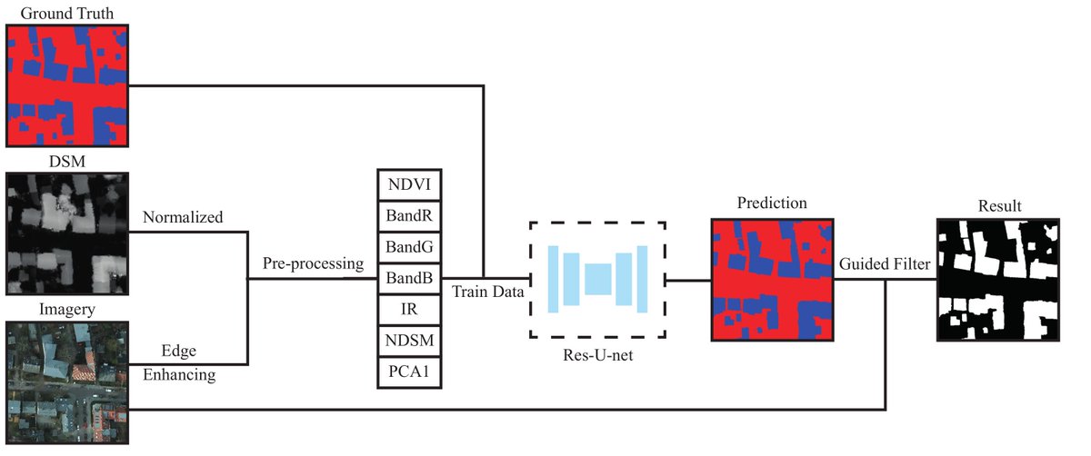
#Building Extraction in #VeryHighResolution Remote Sensing Imagery Using #DeepLearning and Guided Filters 👉mdpi.com/2072-4292/10/1… by Yongyang Xu, Liang Wu, Zhong Xie and Zhanlong Chen #guidedfilter #BuildingExtraction #remotesensing
📢New BOOK #VeryHighResolution (#VHR) #SatelliteImagery: Processing and Applications Francisco Eugenio and Javier Marcello (Eds.) 👉Book link: mdpi.com/books/pdfview/… 👉Special Issue link: mdpi.com/journal/remote…

A #DeepLearning-Based Robust #ChangeDetection Approach for #VeryHighResolution Remotely Sensed #Images with Multiple Features by Lijun Huang, Ru An, et al. 👉mdpi.com/2072-4292/12/9… #remotesensing

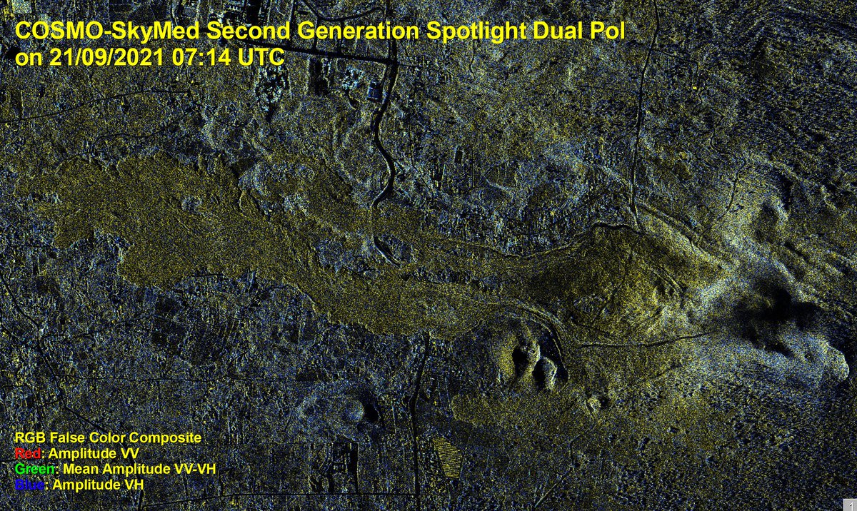
Yesterday, the Italian #COSMOSkyMed-Second Generation radar satellite (@ASI_spazio/@MinisteroDifesa) captured for @CopernicusEMS #EMSR546 #VeryHighResolution #DualPol image of the #ErupciónLaPalma, showing how the lava front has advanced by 330 metres in just a few hours.
Automatic Windthrow Detection Using #VeryHighResolution #Satellite #Imagery and #DeepLearning by Dmitry E. Kislov and Kirill A. Korznikov 👉mdpi.com/2072-4292/12/7… #CNN #machinelearning #forestdisturbance #remotesensing
#mostdownloaded 📢 An Object-Oriented Approach to the Classification of Roofing Materials Using #VeryHighResolution #SatelliteStereo-Pairs by Francesca Trevisiol, Alessandro Lambertini, Francesca Franci and Emanuele Mandanici 🔗 Read the full article: mdpi.com/2072-4292/14/4…


SPECIAL ISSUE article: S. Pang et. al. propose a novel, robust end-to-end Siamese correlation and attention-based #ChangeDetection network (SCA-CDNet) for bitemporal, #VeryHighResolution imagery. 🔗 doi.org/10.1080/014311… #IJRS #RemoteSensing #ResNet

B.A. Semcheddine & A. Daamouche propose a new technique for the extraction of spatial features from #veryhighresolution (#VHR) imagery based on matched filters. 🔗 doi.org/10.1080/014311… #IJRS #RemoteSensing #SupportVectorMachines #ParticleSwarm
E. Halme (@VTTFinland) & colleagues estimate mean tree crown diameter in #borealforest through analysis of #variograms and amplitude spectra of #veryhighresolution (0.7 m) #optical imagery. 🔗 doi.org/10.1080/014311… #IJRS #RemoteSensing #opticalRS #forestry


We are going to #CAPIGI2018 in The #Netherlands next week, hear Dr Melanie Rankl speak & visit our stand for some goodies and information on our #VeryHighResolution #satellite images 😀🌿🛰️ @CAPIGI2018 #Geospatial #RemoteSensing #Agriculture #SmartFarming #CAP


📢 Announcing our new partnership with @Maxar Technologies! ONDA now offers #VeryHighResolution 𝗼𝗽𝘁𝗶𝗰𝗮𝗹 satellite imagery - 𝘂𝗽 𝘁𝗼 𝟯𝟬 𝗰𝗺- from Quickbird, IKONOS, GeoEye-1 and WorldView-1, -2, -3 & -4. More info: bit.ly/2TclFGV #VHR #peopleONDAta

Did you know that you can now request archived or new #VeryHighResolution imagery (up to 40 cm) of both #SAR and optical acquisitions from ONDA? Get started: bit.ly/2kOwd1B Read more: bit.ly/2lPTf8L #peopleONDAta

🔔 New REVIEW article: Srivastava et al. present a #LiteratureReview exploring methods for extracting building footprints from #VeryHighResolution remotely sensed imagery, using a variety of #DeepLearning methods. 🔗 doi.org/10.1080/014311… #IJRS #RemoteSensing

Very pleased to announce our recent partnership with @deimosimaging for the provision of images acquired by #DEIMOS2, a #VeryHighResolution (75 cm) #multispectral optical satellite. 🖥️ Request VHR data: bit.ly/2kOwd1B ℹ️ Read more: bit.ly/2kmGhyG


#MyPlanetMaps now offers on-demand @AirbusSpace #VeryHighResolution Imagery complementary to its raster and vector layers! Also, this online map service seamlessly integrates into your #GIS solutions. Find out more: planetobserver.com/myplanetmaps-o… #WMTS #GeoServices #Geospatial

🔔 New REVIEW article: Srivastava et al. present a #LiteratureReview exploring methods for extracting building footprints from #VeryHighResolution remotely sensed imagery, using a variety of #DeepLearning methods. 🔗 doi.org/10.1080/014311… #IJRS #RemoteSensing
#mostdownloaded 📢 An Object-Oriented Approach to the Classification of Roofing Materials Using #VeryHighResolution #SatelliteStereo-Pairs by Francesca Trevisiol, Alessandro Lambertini, Francesca Franci and Emanuele Mandanici 🔗 Read the full article: mdpi.com/2072-4292/14/4…
SPECIAL ISSUE article: S. Pang et. al. propose a novel, robust end-to-end Siamese correlation and attention-based #ChangeDetection network (SCA-CDNet) for bitemporal, #VeryHighResolution imagery. 🔗 doi.org/10.1080/014311… #IJRS #RemoteSensing #ResNet
B.A. Semcheddine & A. Daamouche propose a new technique for the extraction of spatial features from #veryhighresolution (#VHR) imagery based on matched filters. 🔗 doi.org/10.1080/014311… #IJRS #RemoteSensing #SupportVectorMachines #ParticleSwarm
#MyPlanetMaps now offers on-demand @AirbusSpace #VeryHighResolution Imagery complementary to its raster and vector layers! Also, this online map service seamlessly integrates into your #GIS solutions. Find out more: planetobserver.com/myplanetmaps-o… #WMTS #GeoServices #Geospatial
E. Halme (@VTTFinland) & colleagues estimate mean tree crown diameter in #borealforest through analysis of #variograms and amplitude spectra of #veryhighresolution (0.7 m) #optical imagery. 🔗 doi.org/10.1080/014311… #IJRS #RemoteSensing #opticalRS #forestry
Check out how #GEOSAT2 is able to show the evolution of #CumbreViejaVolcano over time. Its #VeryHighResolution images enable to visualize the delta growth until its outflow into the sea, as well as the changes in the lava flow in great detail. #ErupcionLaPalma #LaPalmaVolcano
Yesterday, the Italian #COSMOSkyMed-Second Generation radar satellite (@ASI_spazio/@MinisteroDifesa) captured for @CopernicusEMS #EMSR546 #VeryHighResolution #DualPol image of the #ErupciónLaPalma, showing how the lava front has advanced by 330 metres in just a few hours.
A #DeepLearning-Based Robust #ChangeDetection Approach for #VeryHighResolution Remotely Sensed #Images with Multiple Features by Lijun Huang, Ru An, et al. 👉mdpi.com/2072-4292/12/9… #remotesensing
Something went wrong.
Something went wrong.
United States Trends
- 1. #GMMTV2026 308K posts
- 2. Moe Odum N/A
- 3. #WWERaw 76.2K posts
- 4. Panthers 37.7K posts
- 5. Purdy 28.3K posts
- 6. Finch 14.6K posts
- 7. TOP CALL 9,298 posts
- 8. Keegan Murray 1,520 posts
- 9. Bryce 21.2K posts
- 10. 49ers 42.2K posts
- 11. AI Alert 7,965 posts
- 12. Canales 13.5K posts
- 13. Timberwolves 3,870 posts
- 14. Alan Dershowitz 2,653 posts
- 15. Gonzaga 4,079 posts
- 16. Check Analyze 2,385 posts
- 17. Token Signal 8,549 posts
- 18. Market Focus 4,745 posts
- 19. #FTTB 5,934 posts
- 20. Penta 10.8K posts