#winterwx search results


SECOND CALL THIS EVENING | Loving what in seeing on recent OBS and Model data over the past 12 hours for a HIGH-END Blizzard for many along the East coast. Models are beginning to agree on favorable vertical stacking [500-850mb] supporting a strong moisture pull.. #Winterwx
![DeAndre_Weather's tweet image. SECOND CALL THIS EVENING |
Loving what in seeing on recent OBS and Model data over the past 12 hours for a HIGH-END Blizzard for many along the East coast.
Models are beginning to agree on favorable vertical stacking [500-850mb] supporting a strong moisture pull..
#Winterwx](https://pbs.twimg.com/media/HBtLwezW8AAH_Gd.jpg)
POTENTIAL BLIZZARD FORECAST | The idea of bomb cyclone developing off the coast of the NEUS is increasing late this weekend into early Next Week. Higher snowfall rates along with strong winds for a prolong period of time will allow for blizzard conditions. What to expect?


#BREAKING Reports that people are getting this notification on there phones if you live in Kansas. #winterwx #mowx #kswx


A peaceful scene in Fairbanks, AK with light snow coming down. ❄️🌨️🌨️ Alaska won't be alone with the winter weather....... an artic blast will bring cold temps and snow to the plains and NW later this week! #winterwx #arcticair #snow

Snow and ice are covering the ground and roads in Memphis, TN, and in surrounding areas. Take the necessary precautions to stay safe with these hazardous conditions! 📸: Matthew Keyes in Olive Branch, MS #tnwx #mswx #winterwx #snow #ice


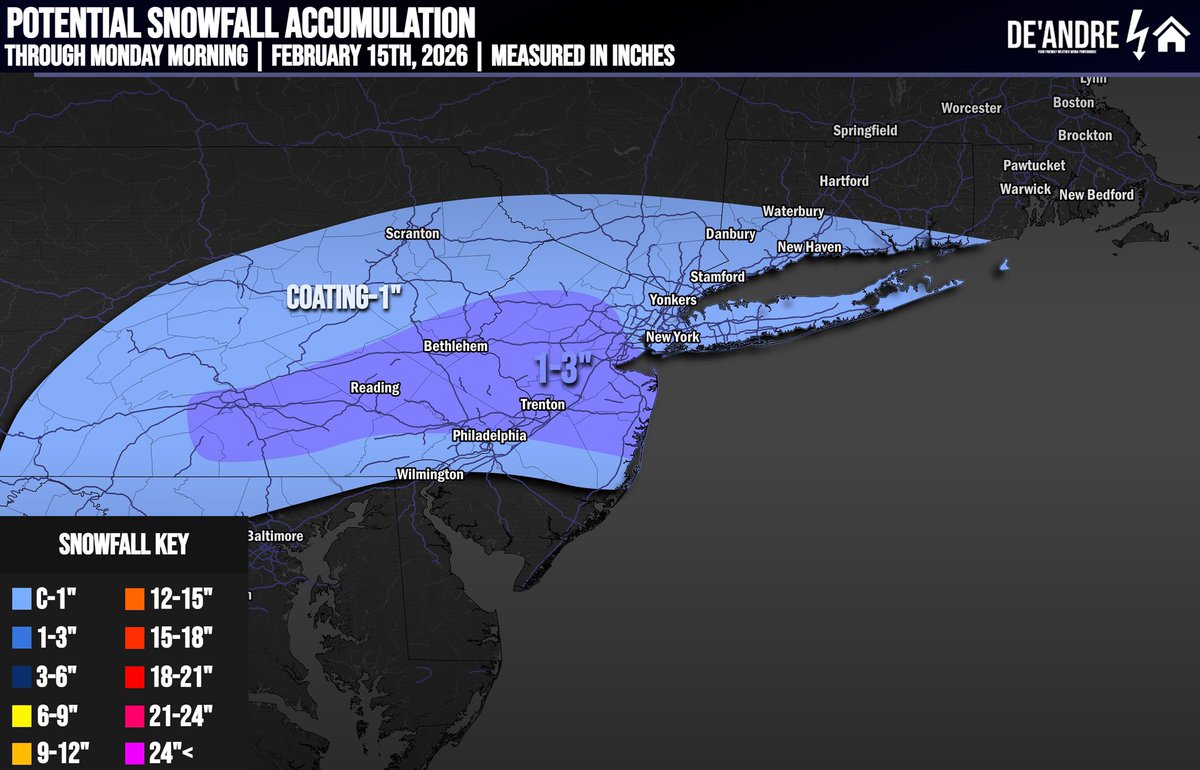
SNOWFALL TOTALS | FINAL CALL Following up from last nights thread a Light snowfall event is expected tonight into Monday Morning. Marginal temperatures throughout the day will cause for precipitation to begin as rain before snow breaking out of overnight. #Winterwx #ECwx
#BREAKING Nearly every major highway has been closed due to snow drifts and the inability for plows to keep them clear. Don't go out...cause you can't go anywhere. #winterwx #mowx #kswx

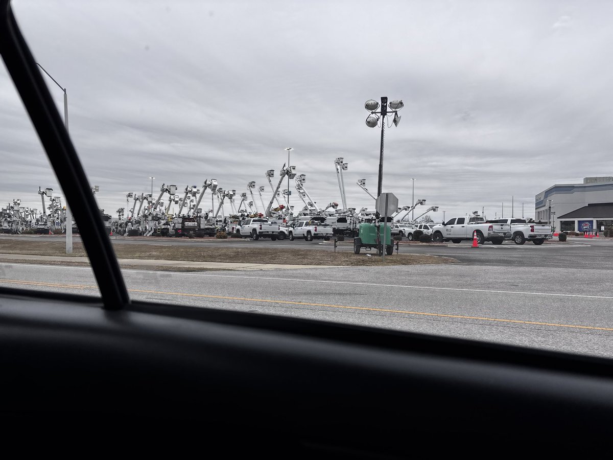
Let’s all give a big thanks to the lineman workers who are ready and setup to hopefully keep the power on during this weekend’s winter storm. Huge gathering at the Florence Center. You guys rock! #scwx #flowx #winterwx

Fun Fact: The two snow squall warnings that were issued this evening were the first ever put out by our office here in Omaha! However, nothing like the snow squalls out in @NWSStateCollege 's area! They can keep those out there 💓 #snow #winterwx #newx #iawx #readyforsummer

A Winter Weather Advisory has been issued for Holmes, Jackson, and Washington counties. #winterwx #pcb #NWFL

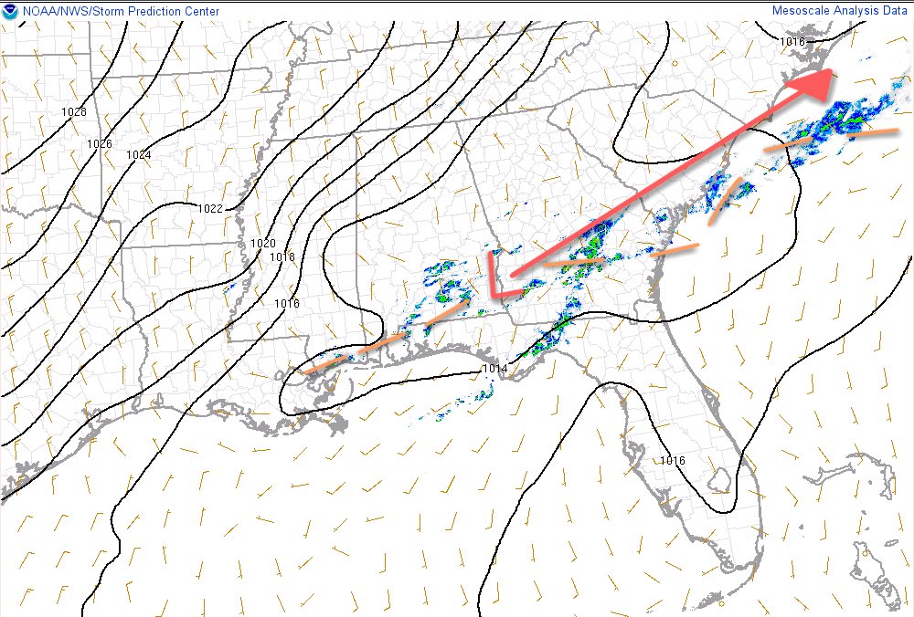
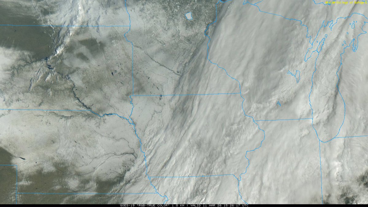
We can see the pieces of our system beginning to align on Mesoscale Analysis tonight w/ our Sfc Low Development, building upper-air dynamics, visible lift on MRMS, and our Shortwave moving SE. Phase timing will be key for many. Nowcasting continues! #Winterwx


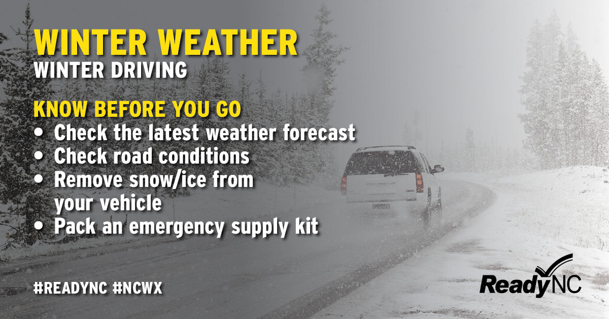
Winter precipitation can create hazardous conditions on the roads. The safest thing to do during winter storms is to stay home, but if you must travel, keep these tips in mind. #ncwx #WinterWx

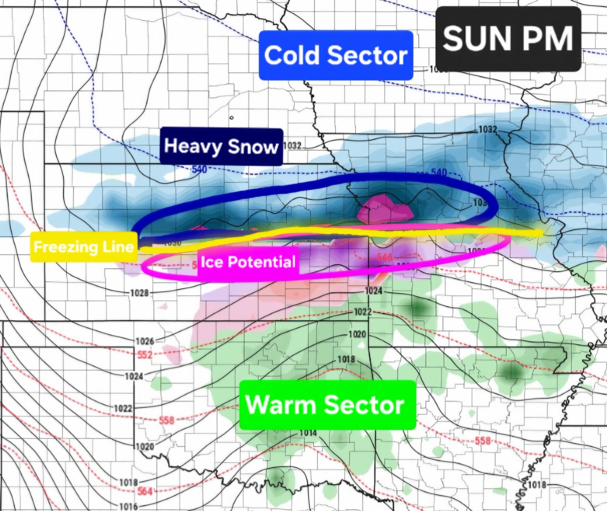
|EURO MSLP+Precip+Dew Points // This Sunday| A strong storm system is likely this weekend with heavy snow across cold sector and severe weather along cold front in warm sector Sunday. Trends to monitor. @NWSSPC #NOAA #SevereWx #WinterWx


Durante el invierno, lleve las mascotas adentro de la casa. Traslade otros animales o ganado a zonas protegidas con agua potable no congelada. También puede obtener más consejos sobre la seguridad de las mascotas en ReadyNC.gov. #WinterWx
Look at this snowpack over the Northern Mississippi River Valley and North-Central Plain from the Winterstorm that occurred north of the Tornado Outbreak last Night! Above freezing Temperatures should allow rapid melting today! #Winterwx

Our big boi blizzard is taking shape. We see the low pressure area off the Mid-Atlantic coast in the form of this dry slot that is trying to resemble an eye. The precip shield is onshore & the snow will get heavier as time goes on. #USAwx #winterwx
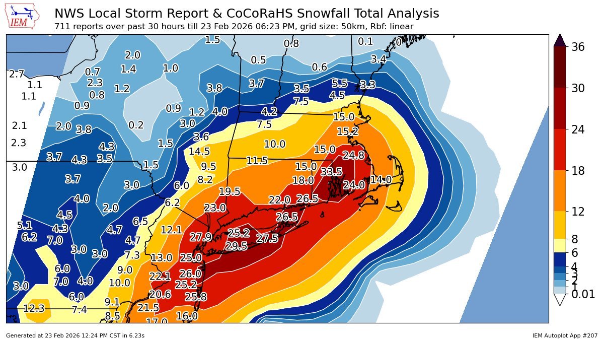
This blizzard's snow totals have really piled on. Now many places are well over 2ft. 33.5in was recorded in Warwick, #RhodeIsland as of now. #RIwx #winterwx
Alright Tampa Bay Area, time for your annual dose of snow. Wait… what’s that? They don’t get this often? Oh Well consider yourself fortunate. Cen. #Florida is likely to experience Gulf effect snow & may have very light accumulation this weekend. #FLwx #winterwx

BLIZZARD OF 2026 FORECAST | A Powerful Winterstorm will develop Sunday afternoon with bombogenesis occurs off the coast. Dangerous blizzard conditions will occur from I-95 east with damaging wind gusts up to 30-50 mph causing whiteout conditions and power outages. #Winterwx

(9:00pm) - Some light snow is moving across southern Iowa into northern Missouri. A light dusting to 1" is possible. I know it's April.. Take roads slow if traveling. #iawx #mowx #WinterWx

Telling Vortix Jr this is a snowicane. But we have a nice low pressure area spinning about in the Gulf of #Alaska just offshore of Cordova, AK. #AKwx #winterwx

1.1 inches of fluffy snow at my place in Bethany KY. What are you all seeing? #wx #winterwx as of 330 pm @nwsjacksonky @Kentuckyweather @cjwxguy56 @AlexaMintonWX


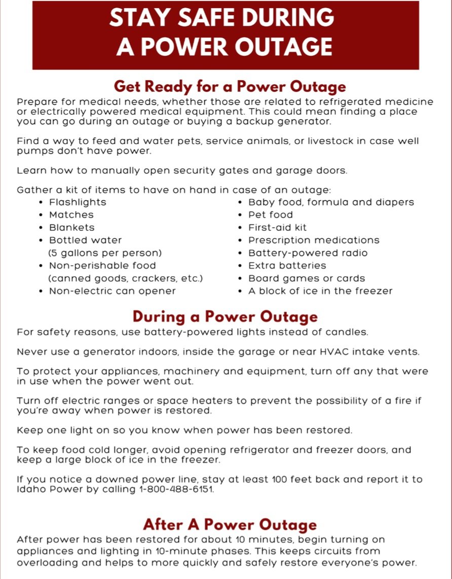
Millions of people across US will be at risk of power outages. Don't wait until you lose power, prepare your family and property ahead of potential weather-related power outage. @NOAA #WeatherSafety #SevereWx #WinterWx
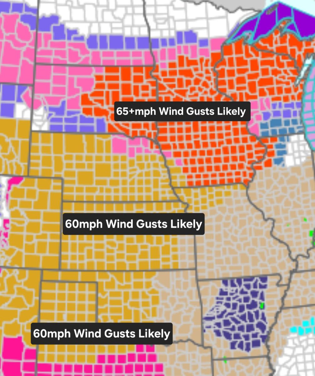
Across the cold sector of this strong storm system for Sunday.. Very high winds and blizzard conditions are likely from northern plains (65+kts) to central/southern plains (60kts). This will reduce visibilities and make travel hazardous to impossible. @NWSSPC #WinterWx
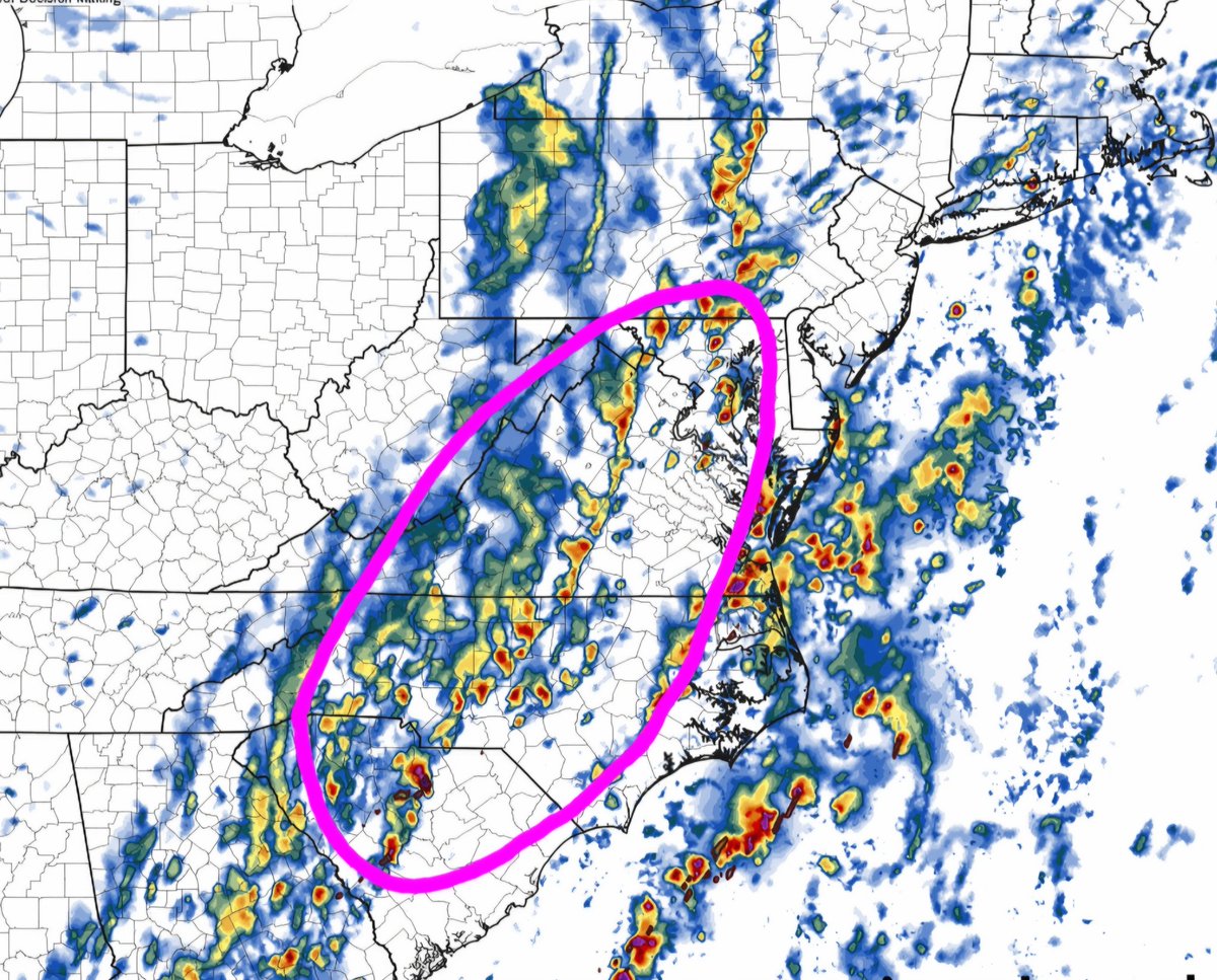
(3/3): 𝐌𝐨𝐧𝐝𝐚𝐲 (𝐒𝐞𝐯𝐞𝐫𝐞 𝐏𝐨𝐭𝐞𝐧𝐭𝐢𝐚𝐥): Strong cold front moves east with continued significant severe wind event shaping up from southern PA to NC with severe winds up to 75-80mph. @NWSSPC @hellohannav #NOAA #SevereWx #WinterWx

|Throwback to June 03, 2025 in Independence, MO| Some winter weather/cold is possible Sunday in Independence. 👎 We are entering tornado season. Mentally I'm here. 🌪 March madness ❄🌪 #NOAA #SevereWx #WinterWx
Due to strong storm system bringing both significant snow and severe weather Sunday and Monday. I will be working all weekend providing updates and keeping you posted. @NWSSPC #NOAA #SevereWx #WinterWx google.com/maps/d/u/0/hom
(1/3) |Sunday // March 15| @NWSSPC @hellohannav #WinterWx #SevereWx 𝐎𝐯𝐞𝐫𝐯𝐢𝐞𝐰: A strong storm system will move through east of The Rockies with blizzard conditions in cold sector and significant severe wind event across warm sector.


|EURO MSLP+Precip+Dew Points // This Sunday| A strong storm system is likely this weekend with heavy snow across cold sector and severe weather along cold front in warm sector Sunday. Trends to monitor. @NWSSPC #NOAA #SevereWx #WinterWx
Look at this snowpack over the Northern Mississippi River Valley and North-Central Plain from the Winterstorm that occurred north of the Tornado Outbreak last Night! Above freezing Temperatures should allow rapid melting today! #Winterwx

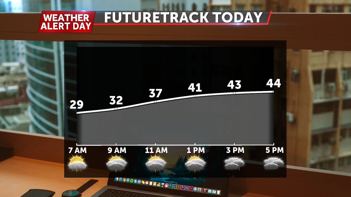
WINTRY END TO WEEKEND - It'll be dry most of the day, but widespread rainfall that transitions into sleet and snow for some is on track to enter Central Missouri this evening. This will exit tomorrow morning, leaving minor travel impacts for some. @ABC17News #midmowx #winterwx
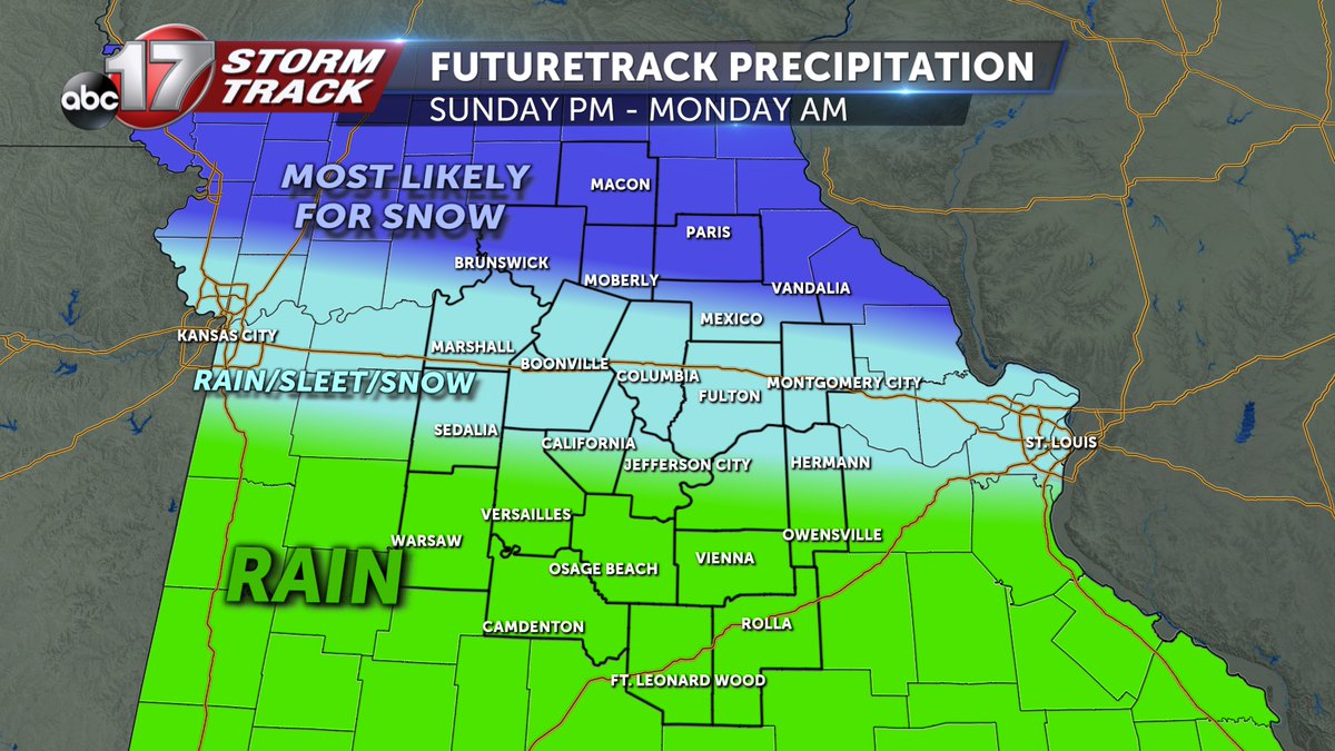
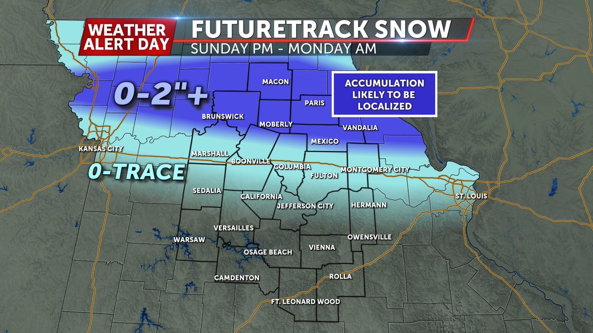
|GFS MSLP+Precip // Sunday PM| The focus this Sunday will be on how far north/south "freezing line" makes it. That will make difference in liquid rain/ice or snow. I-70 corridor remains best area for frz. rain and sleet. @hellohannav @NWSSPC @NWSWPC #WinterWx #kswx #mowx
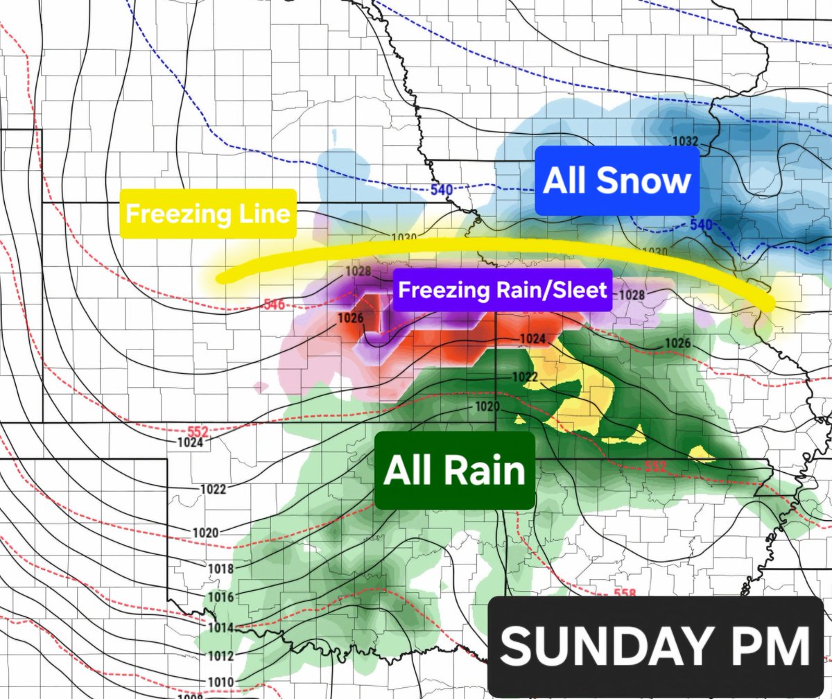
ICYMI: Rain/snow/sleet and freezing rain are all possible this weekend across plains. Fine tuning will be done. Trends being monitored. #WinterWx
|GFS MSLP+Precip // Sunday| A complex winter setup looks to be shaping up across the plains Sunday. Depending on how far north/south freezing line goes will depend how much snow & ice could occur. Trends to monitor. @hellohannav #NOAA #WinterWx #kcwx #kswx #mowx
This blizzard's snow totals have really piled on. Now many places are well over 2ft. 33.5in was recorded in Warwick, #RhodeIsland as of now. #RIwx #winterwx
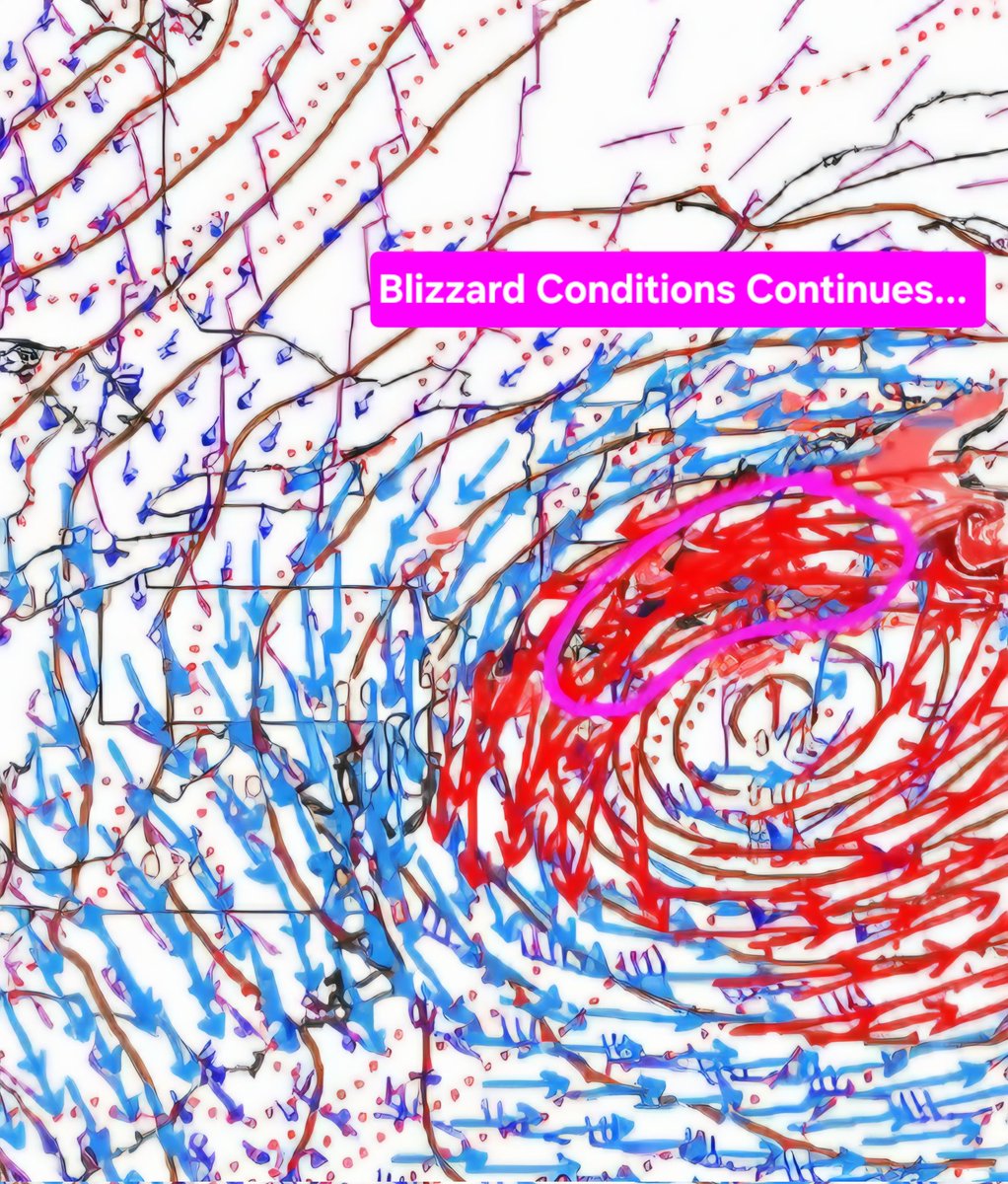
(1628Z) |SLP (mb)/10m BKNT/850mb WAA| Blizzard conditions are ongoing across eastern seaboard with heaviest snow continuing to move north. Wind gusts have been around 60kts -(occasional 75kts). These blizzard conditions will continue into TUE AM. @NWSSPC #nywx #WinterWx
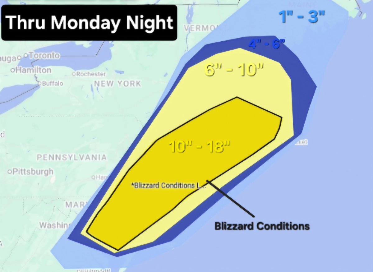
|Additional Snowfall Thru Monday Night| Additional heavy wet snow 10" to 18" is possible along eastern coastal regions along with blizzard conditions ongoing through this evening. @NWSSPC @NWSWPC #NOAA #WinterWx
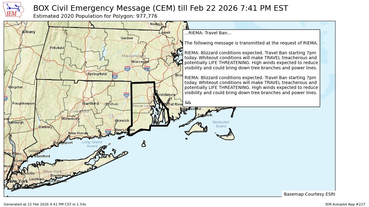
All of #RhodeIsland is under a travel ban due to this blizzard. #RIwx #winterwx

#BOX issues Civil Emergency Message (CEM) at Feb 22, 5:41 PM EST ...RIEMA: Travel Ban... mesonet.agron.iastate.edu/p.php?pid=2026…


#BREAKING Reports that people are getting this notification on there phones if you live in Kansas. #winterwx #mowx #kswx
A Winter Weather Advisory has been issued for Holmes, Jackson, and Washington counties. #winterwx #pcb #NWFL
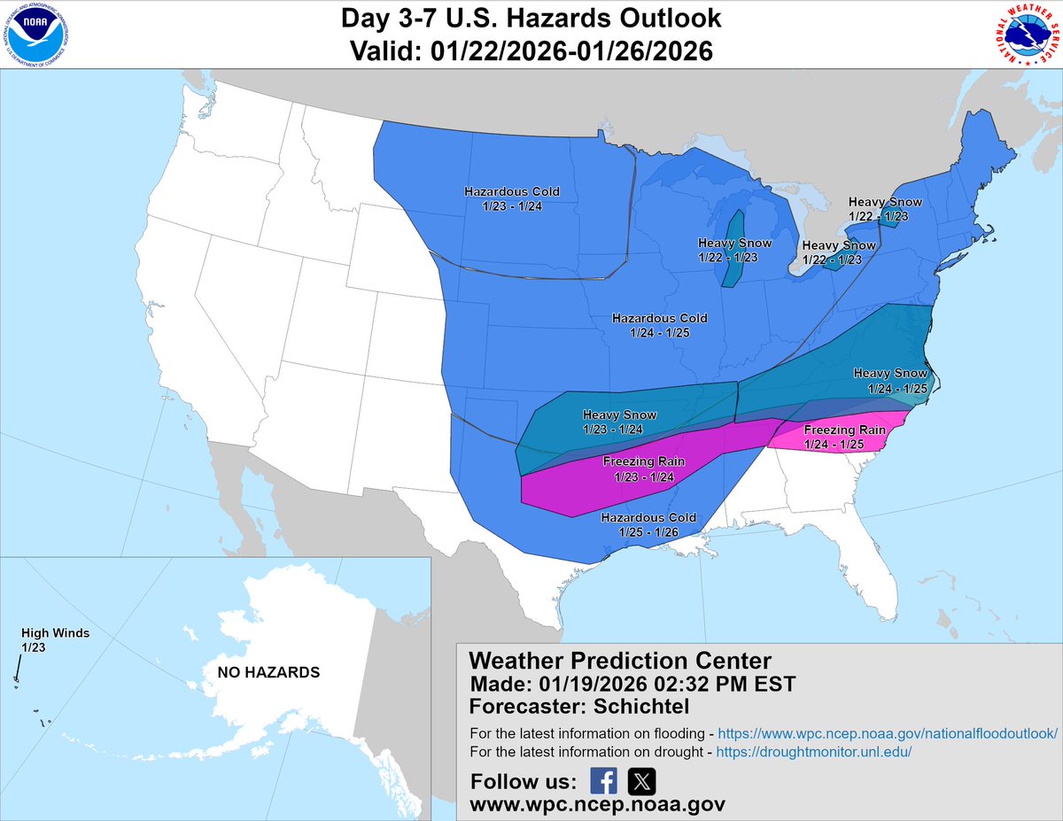
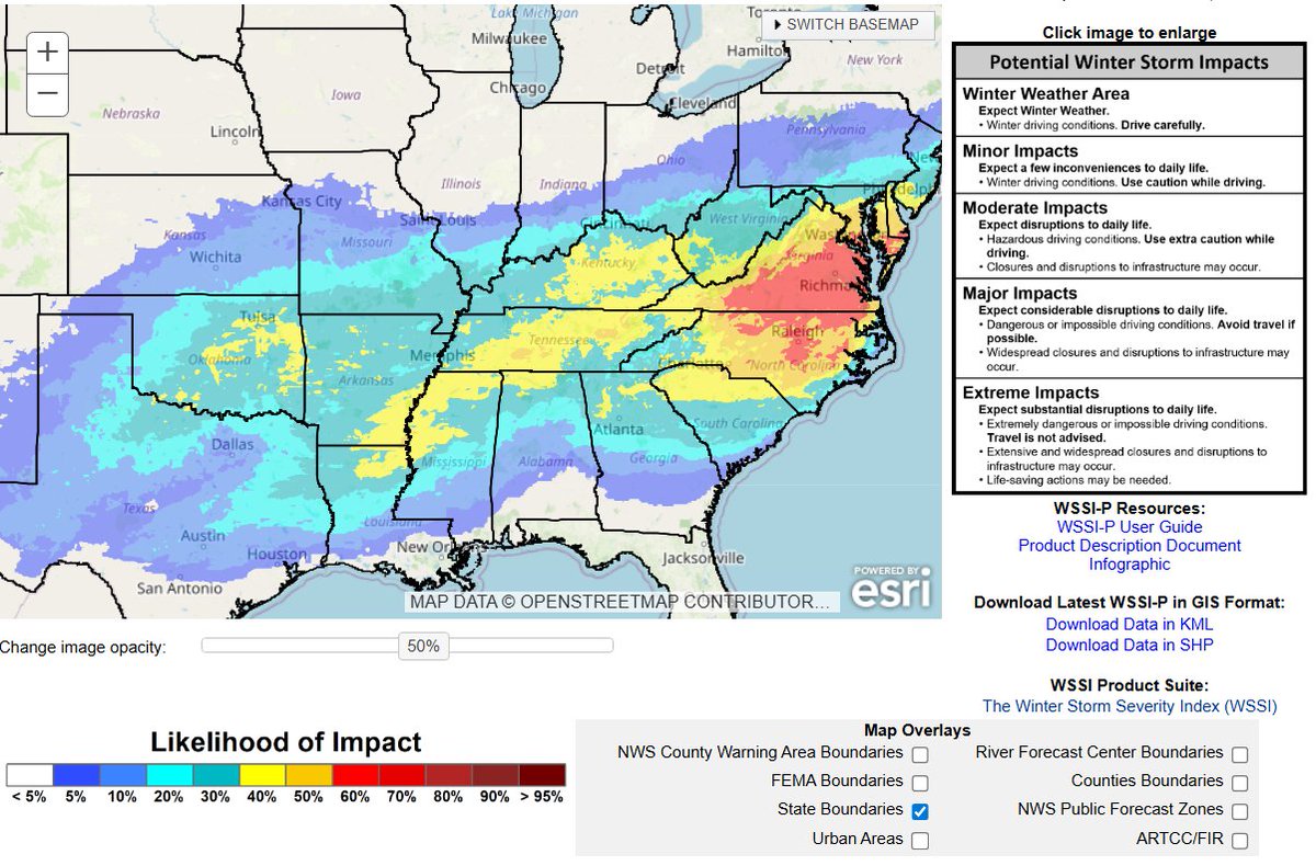
#USAwx #winterwx A major winter storm is expected to shape up from the S Plains to the Mid-Atlantic coming this weekend. Areas of heavy snow & freezing rain are looking likely for those areas + bitter cold. There's a widespread area of moderate impacts on the WSSI but major

SNOWFALL TOTALS | FINAL CALL Following up from last nights thread a Light snowfall event is expected tonight into Monday Morning. Marginal temperatures throughout the day will cause for precipitation to begin as rain before snow breaking out of overnight. #Winterwx #ECwx
#BREAKING Nearly every major highway has been closed due to snow drifts and the inability for plows to keep them clear. Don't go out...cause you can't go anywhere. #winterwx #mowx #kswx
We can see the pieces of our system beginning to align on Mesoscale Analysis tonight w/ our Sfc Low Development, building upper-air dynamics, visible lift on MRMS, and our Shortwave moving SE. Phase timing will be key for many. Nowcasting continues! #Winterwx
Fun Fact: The two snow squall warnings that were issued this evening were the first ever put out by our office here in Omaha! However, nothing like the snow squalls out in @NWSStateCollege 's area! They can keep those out there 💓 #snow #winterwx #newx #iawx #readyforsummer
Snow and ice are covering the ground and roads in Memphis, TN, and in surrounding areas. Take the necessary precautions to stay safe with these hazardous conditions! 📸: Matthew Keyes in Olive Branch, MS #tnwx #mswx #winterwx #snow #ice
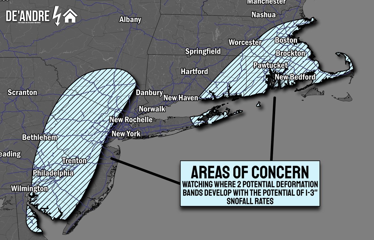
Watching the potential for Two areas that could experience prolonged snowfall rates from 1-3" per hour during the peak of Sunday-Monday's Blizzard. I have a bit of confidence that this is where our Deformation bands will stall but these locations are not locked in. #Winterwx
|EURO MSLP+Precip+Dew Points // This Sunday| A strong storm system is likely this weekend with heavy snow across cold sector and severe weather along cold front in warm sector Sunday. Trends to monitor. @NWSSPC #NOAA #SevereWx #WinterWx
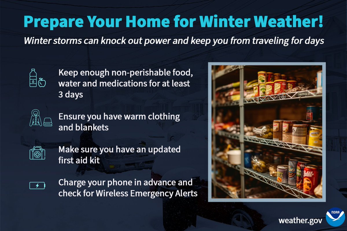
Prepare your home for emergencies associated with winter conditions! Winter storms can create power outages and keep you from traveling for days. Keep enough non-perishable food, water, and medications for at least 3 days. #ReadNC #WinterWx
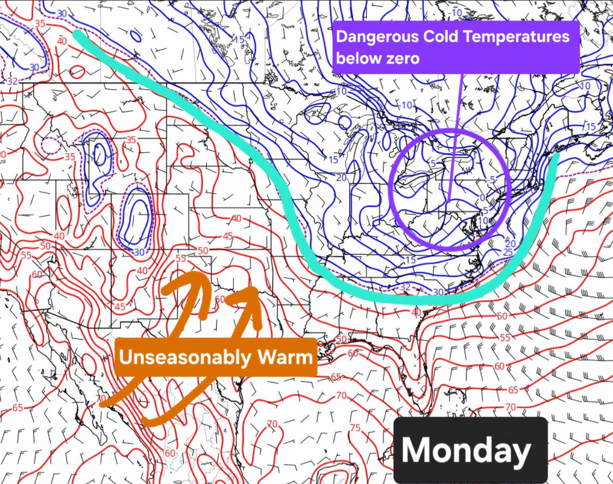
|EURO Temperature Contours // Monday| The tale of two seasons will appear on Monday with unseasonable warmth across plains/southwest, arctic cold across northeast. @NWSCPC @NWSSPC @hellohannav #NOAA #WinterWx #Spring
BLIZZARD OF 2026 FORECAST | A Powerful Winterstorm will develop Sunday afternoon with bombogenesis occurs off the coast. Dangerous blizzard conditions will occur from I-95 east with damaging wind gusts up to 30-50 mph causing whiteout conditions and power outages. #Winterwx
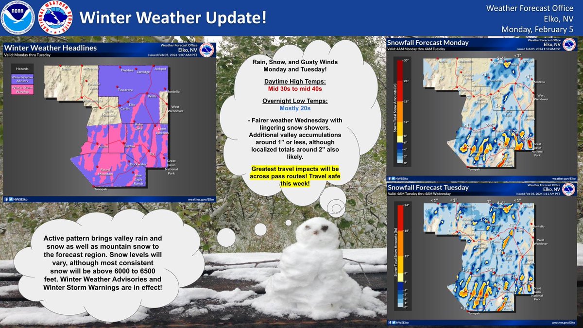
The first in a series of Pacific storm systems move into central NV late today, spreading precipitation east and north along with gusty winds. Slow down and use caution while driving. #nvwx #winterwx #travelsafe
#BREAKING Blizzard Warnings has been extended into northwestern Missouri just north of Kansas City metro. Expect gusty winds up to 40 mph or greater & whiteout conditions.#winterwx #kswx #mowx

BLIZZARD OF 2026 | FINAL FORECAST Extreme Impacts are likely along the I-95 east with Heavy snowfall rates from 2-4" per hour along with Damaging Wind Gusts from 40-50mph [60-70mph near Cape Cod]. Road conditions will be dangerous so please avoid traveling if possible. #Winterwx
![DeAndre_Weather's tweet image. BLIZZARD OF 2026 | FINAL FORECAST
Extreme Impacts are likely along the I-95 east with Heavy snowfall rates from 2-4" per hour along with Damaging Wind Gusts from 40-50mph [60-70mph near Cape Cod].
Road conditions will be dangerous so please avoid traveling if possible. #Winterwx](https://pbs.twimg.com/media/HBw_I_wXIAEz2vW.jpg)

We have #snow covered roads in Harrington, DE on Rt-13 at Jackson Ditch Rd. #winterwx #deltraffic @cbsphiladelphia


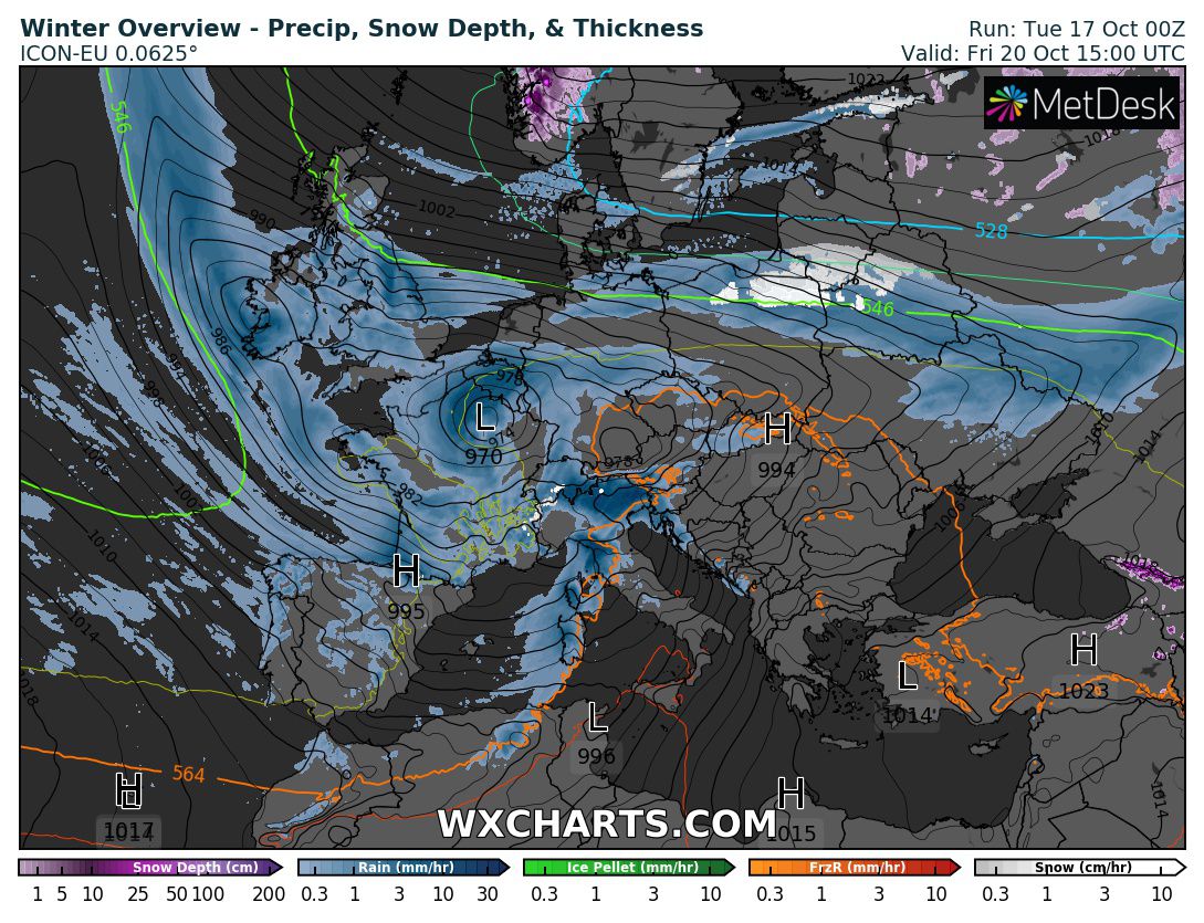
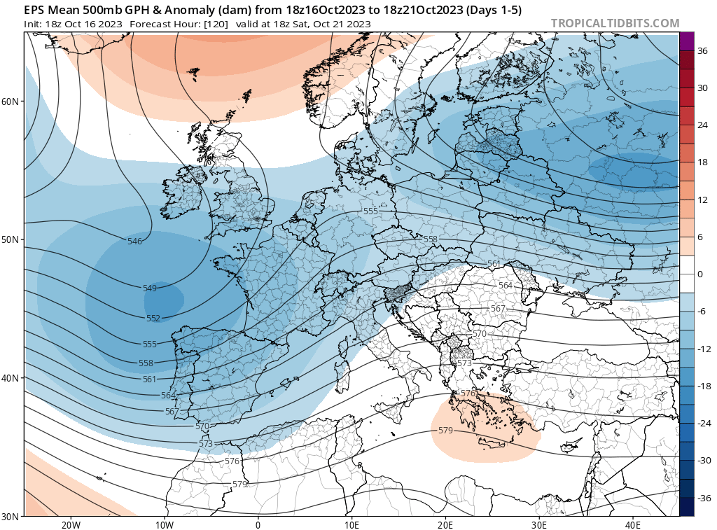
While chances have diminished, there is still a chance for some early #snow in parts of central Europe over the weekend. It will all depend on where the airmass boundary will be located and that in turn would depend on low placement. Quite the complex setup... #EUwx #winterwx.

It was quite active this past week with severe weather on Wednesday and Saturday in MS and throughout the SE US. Another eventful week may be in store as there is the potential for record low temps and possible winter weather. @msuweather #mswx #severewx #winterwx


Something went wrong.
Something went wrong.
United States Trends
- 1. Golden Tempo N/A
- 2. #KentuckyDerby N/A
- 3. Great White N/A
- 4. Tatum N/A
- 5. Cherie DeVaux N/A
- 6. NINGNING NYC TAKEOVER N/A
- 7. Jaylen Brown N/A
- 8. Celtics N/A
- 9. So Happy N/A
- 10. Renegade N/A
- 11. Spirit N/A
- 12. Jose Ortiz N/A
- 13. Luka Garza N/A
- 14. Further Ado N/A
- 15. Chief Wallabee N/A
- 16. Sixers N/A
- 17. #MetGala2026 N/A
- 18. Emerging Market N/A
- 19. Ron Harper Jr. N/A
- 20. Reds N/A