#bowecho search results

A #BowEcho moving through the #Upstate now. Expect strong to damaging winds near and along this! #SCwx Radar: tinyurl.com/k8fagps

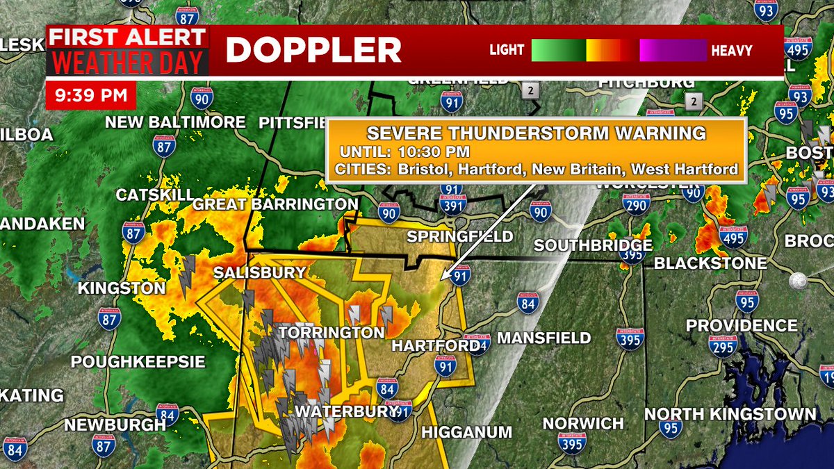
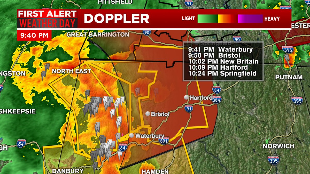
#BowEcho or line of severe storms producing damaging straight line wind gusts is moving toward the lower valley. A Severe Thunderstorm Warning for western Hampden Co. Line moving NE at 45mph. #mawx

That’s a Bow Echo motion you don’t see everyday in the mid-latitudes over both Northern and Southern Hemisphere. #MTWX #BowEcho #Retrograde #QLCS #WxTwitter #Thunderstorms

Love. It! Thanks for sharing! @NWSLittleRock @GarofaloWX @WXnation @kytv #SevereWeather #bowecho #arwx


Veel buienradarsites raken overbelast door vele bezoekers. Juist nu radarvorm gevaarlijk wordt! #bowecho

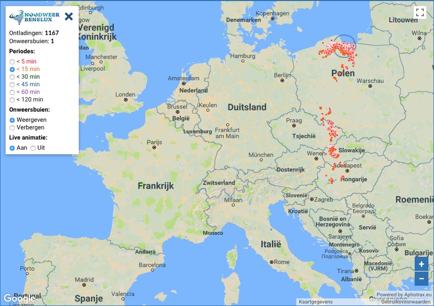
Sterke #signatuur van een #bowecho in het noorden van #Polen. Vermoedelijk forse #windstoten bij dit #onweer. noodweer.be/bliksem-in-det…

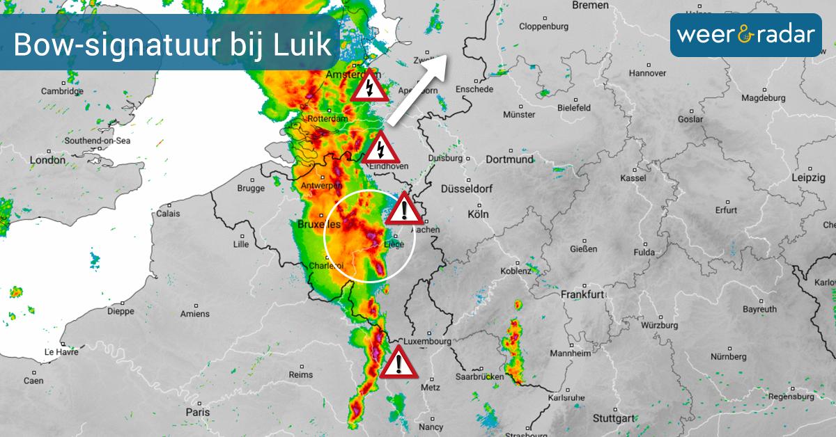
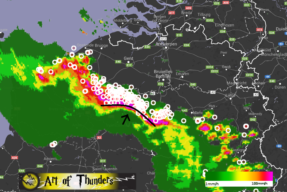
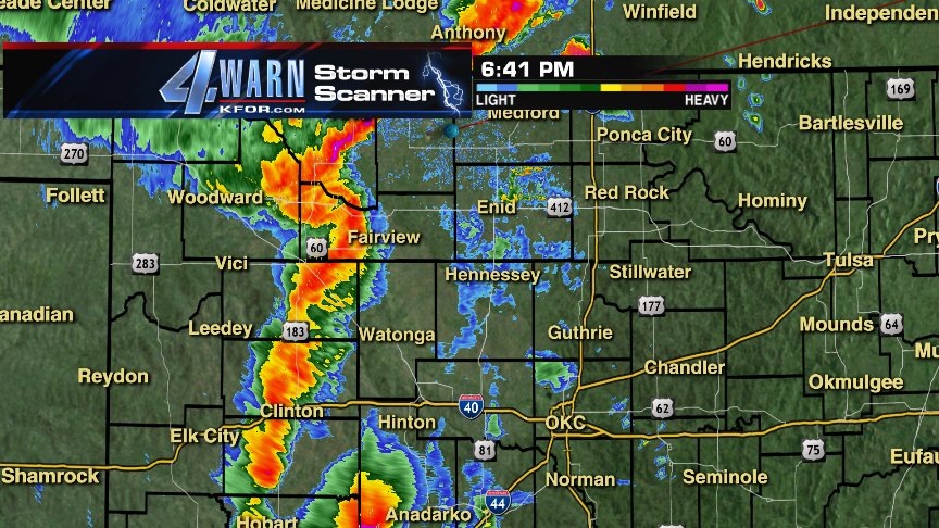
De ProfiRadar toont een zogenaamde #BowEcho signatuur nabij #Luik. Daarop kunnen er zeer zware #windstoten voorkomen. Er ontstaat inmiddels een lineair convectief systeem (QLCS) die de komende uren verder naar het noordoosten trekt. Vanuit Namur zijn er zware windstoten gemeld ⚠️

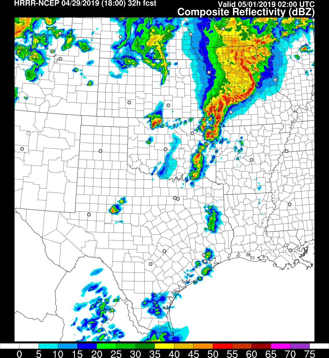
This doesn't look good if reality is anywhere near what the HRRR generates. Will be long day tomorrow. #qlcs #bowecho #mesovortices
Here is a review of the most recent severe weather that affected the North Country on July 8 2014. #BowEcho #Tstorms ow.ly/zthUq
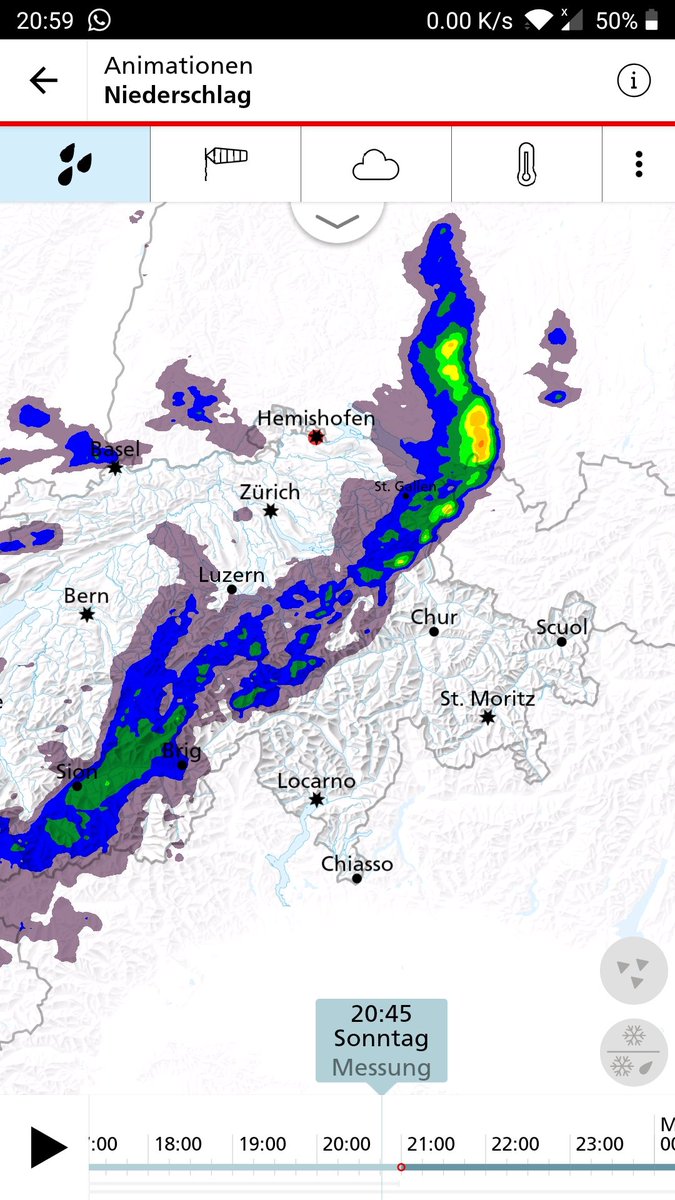
Nederland - "BBQ" alarm. Vanmiddag krijgen we samengaand met opkomend thermische vore (convergentielijn) en #koufront te maken met een goed georganiseerde onweersstoring #bowecho welke van ZW naar NO over het land trekt. Naar verwachting bereikt het onweersfront om circa

Winds ahead of the bow echo coming through Spotsylvania, VA #bowecho #wind #storm #virginia #storms #thunderstorms #severestorms #severeweather @nbcwashington @weatherchannel @JimCantore @weathernetwork @WeatherNation

Animation radar #pluie de la puissante ligne d'#orages qui a traversé la Méditerranée hier formant un impressionnant #BowEcho frappant la #Corse vers 23h/1h avec des rafales de #vent mesurées à 157 km/h à #Ajaccio la Parata et 154 km/h à l'Ile Rousse. (records mensuels)


"An upgrade to higher probabilities might be needed in later outlooks once uncertainties regarding the thermodynamic environment have been mitigated." BRING IT ON! Chase season 2k18 has begun! #wxtwitter #wedges #bowecho


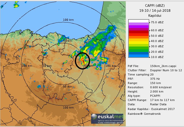
Y en esta imagen del radar de @Euskalmet de las 19:20 PM de ayer vemos a la estructura convectiva q origino la tormenta histórica de #Tafalla #Navarra Observamos claramente la formación de un #BowEcho , en forma arqueada Es una situación extremadamente peligrosa y no muy habitual

While we are on the topic of #MrTornadoPBS, Dr. Fujita also pioneered Bow Echo research, which was not mentioned in the @AmExperiencePBS Mr. Tornado Special. #BowEcho #WxTwitter #StraightLineWind #BookendVortices #cowx #Weather #Mesoscale #Meteorology

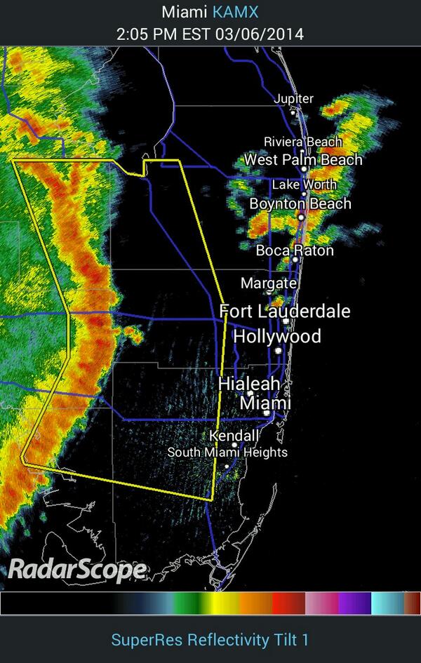
WOW! Strong winds, severe weather racing across Everglades towards Miami and Fort Lauderdale. #bowecho #skytower
#UWAGA! Burza z sygnaturą radarową #bowecho wędruje w stronę @SwietokrzyskiUM. Niesie ona silny / bardzo silny wiatr, powodując powstawanie zniszczeń. Uważajcie na jej trasie! @IMGW_CMM @IMGWmeteo @MeteoprognozaPL #obserwatorzyburz #burza #pogoda #deszcz #polska #lato #burze


.#BowEcho and #Publish are Your new 9-2 jt favs for the #2000Guineas, while #AlbertEinstein is now 12-1 (from 7-2 fav before this afternoon's contest). Full odds: paddypower.com/horse-racing/f…


Say as you wish about the trainer, he’s told the world, even published a video of his last piece of work following waxing lyrical about it. Spoke as if he was already past the post and now he is 👏 #BowEcho


#BowEcho hasn’t done a tap when he’s hit the front - yet he’s just won a Group 2 with little more than strong encouragement. The dream is still alive. 😍 #Newmarket

Cosa sono i temporali a #BowEcho 💦 e perché sono così pericolosi: rischio eventi estremi in Italia nell’autunno 2025? 💦 Articolo di @LucaLombroso 👇. f.mtr.cool/cfvftvzgjp
ilmeteo.net
Cosa sono i temporali a bow echo e perché sono così pericolosi: rischio eventi estremi in Italia...
Eventi estremi nell’autunno 2025? I temporali a bow echo: cosa sono e perché sono pericolosi.


Absolutely, classic up and down! Always tricky to read the odds, but looks like @Pmichaelracing had a good eye. Excited to see how this unfolds! #RacingTalk #BowEcho
I think #BowEcho could be a superstar. Just my opinion. He’s gone through that race like it was a piece of work. Caught on the wrong side of the track when the race developed but still got to the front easily enough. Green when first asked for effort but found plenty. #Haydock

#BowEcho #Haydock #ITVracing Bow Echo wins in the manner of a very smart horse indeed


Aan de voorzijde van de buienlijn (in Vianen) zat een forse shelfcloud. Goede foto's volgen! #bowecho #onweer

This doesn't look good if reality is anywhere near what the HRRR generates. Will be long day tomorrow. #qlcs #bowecho #mesovortices
De ProfiRadar toont een zogenaamde #BowEcho signatuur nabij #Luik. Daarop kunnen er zeer zware #windstoten voorkomen. Er ontstaat inmiddels een lineair convectief systeem (QLCS) die de komende uren verder naar het noordoosten trekt. Vanuit Namur zijn er zware windstoten gemeld ⚠️
#BowEcho or line of severe storms producing damaging straight line wind gusts is moving toward the lower valley. A Severe Thunderstorm Warning for western Hampden Co. Line moving NE at 45mph. #mawx

Stunning #bowecho in Stockach, #Germany back in 2022 by Florian Sabo ⚡ More #storm photos from Florian: bit.ly/floriansabo #wxtwitter #europe @StormFreaksArt @spann @JimCantore @MikeOlbinski @ThePhotoHour @KeraunosObs @severeweatherEU @Kachelmannwettr

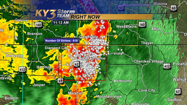
More than 600 lightning strikes JUST in Baxter and Marion Counties in the last 5 minutes! #arwx #bowecho

Konkretna nevihta nad Furlanijo! Zaradi dolgoživosti možni predvsem močni sunki vetra in toča. #bowecho #opozorilo

Imagen radar de las 21.10 horas Desde #TierraEstella se aproxima a la #CuencaDePamplona esa línea que vemos en forma de arco Esta amagando con un #BowEcho Cuidado que puede dar vientos muy muy intenso si sigue así. Hay que ver evolución
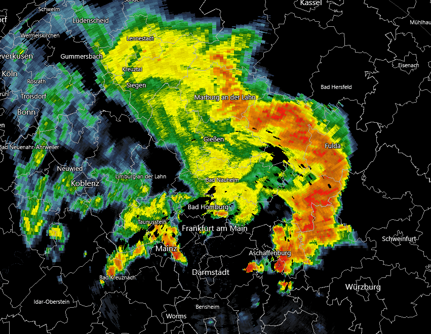
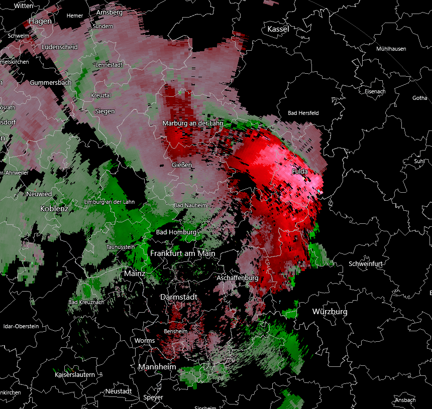
A large #bowecho is in progress over central Germany, severe winds and flash flooding have already occured and are likely to occur as this progresses into the overnight hours! #EUwx #uwde


Squalline vertoont een bow-echo erin! Voornamelijk daar kans op zeer zware #windstoten! #BowEcho #severeweather
Animation radar #pluie de la puissante ligne d'#orages qui a traversé la Méditerranée hier formant un impressionnant #BowEcho frappant la #Corse vers 23h/1h avec des rafales de #vent mesurées à 157 km/h à #Ajaccio la Parata et 154 km/h à l'Ile Rousse. (records mensuels)

Storms just outs of the #WREG @3onyourside area displaying some signs of #bowecho / damaging winds. #staytuned

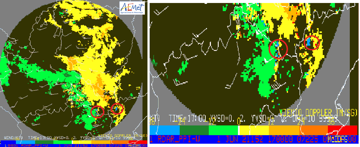
Esta⛈️#BajoAragón dejó señales muy significativas en radar 2D y Doppler, posible formación de #BowEcho, vientos fuertes contrapuestos e intento de formar mesociclón. Img PPIWD viento Doppler de las 19 h. El viento medio en una columna de 3 Km superaba 50 Kt en una línea extensa


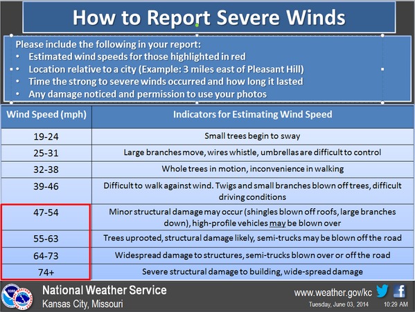
RT @NWSKansasCity: Please use the following for reporting svr winds via social media. #severewinds #derecho #bowecho

How impressive was the storm, the intensity of the storm was unexpected, the phenomenon is called Bow-Echo. #bowecho #bawü #Deutschland #storm


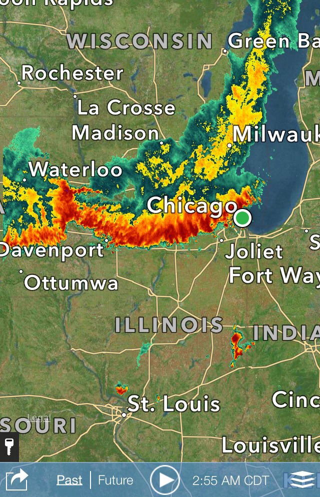
Large #bowecho line #severestorms crossing #Chicago 3AM poss 60mph+ #StraightlineWinds @fox32news @GoodDayChicago
Something went wrong.
Something went wrong.
United States Trends
- 1. #WWERaw N/A
- 2. Jaden Ivey N/A
- 3. #CreaoAI N/A
- 4. Bulls N/A
- 5. Ryan Walker N/A
- 6. Gunther N/A
- 7. Gudas N/A
- 8. #BELIFT_Do_Better N/A
- 9. Parker Messick N/A
- 10. Pistons N/A
- 11. Mania N/A
- 12. Tyler Robinson N/A
- 13. Domi N/A
- 14. The NBA N/A
- 15. Agot Makeer N/A
- 16. Paul Blackburn N/A
- 17. Tanner Scott N/A
- 18. #FOREVER_WITH_7ENHA N/A
- 19. #BOYCOTT_BLOODSAGA N/A
- 20. Michael Soroka N/A