#firewx resultados de búsqueda

A fire in Wasco County, OR, exploded to 3,500 acres with 0% containment, forcing evacuations and closing I-84. Winds pushed flames uphill as crews rushed in—OSFM footage shows Multnomah Co. Task Force mobilizing. At least 20 homes lost. #firewx #orwx

Radar loop of a fire coming from Rome, #Georgia. This is due to a huge fire from the Floyd County Courthouse. #GAwx #firewx
Terrible fire from a plane crash can be seen on radar near Muhammad Ali Intl. Airport in Louisville, #Kentucky. #KYwx #firewx

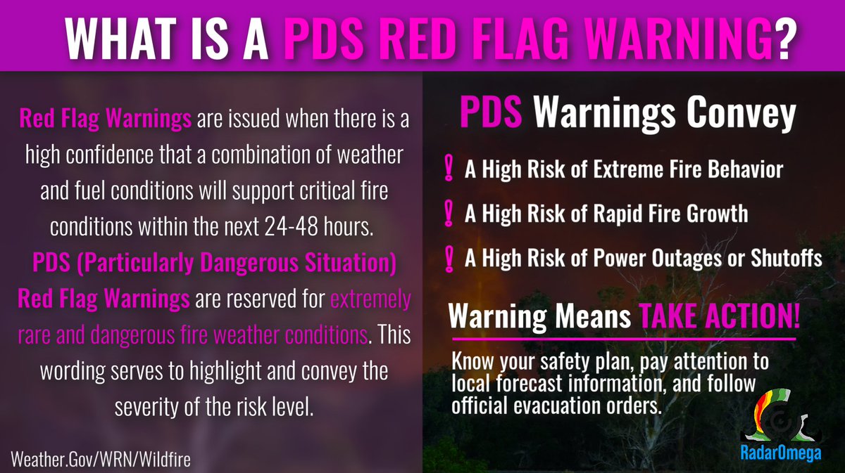
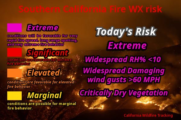
PDS Red Flag Warnings adopt critical language to indicate extreme fire weather conditions present. Strong winds, very low humidity, and dry fuels can lead to explosive fire growth. Avoid any activity that could start a fire, conditions are particularly dangerous. #FireWX
Spooky scene as thick smoke fills the air due to the France Canyon Fire in southern Utah. Winds and dry conditions continue to fuel the blaze, now over 9,500 acres. Air quality in the area has taken a hit as the fire rages on. #firewx #utwx
Stay safe this weekend as elevated fire danger continues for places like Graham County, AZ due to dry and windy conditions. This was the scary view of the Bryce fire earlier on Friday. #azwx #firewx
Check out this insane "firenado" seen on Saturday that became so strong that you can actually see debris being thrown around! Intense firenadoes can create winds equal to an EF3 tornado! The #DeerCreekFire has burned over 10,000 acres with 0% containment. #UTwx #firewx
Satellite imagery shows the moment a massive explosion erupted at a fireworks warehouse in Northern California on Tuesday, igniting multiple blazes, including the Oakdale Fire. #firewx #cawx
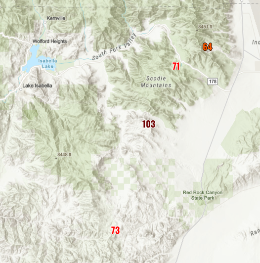
The #GarnettFire east of Fresno, CA continues to burn. As of the latest update, the fire has burned 21,700 acres and is 12% contained. #CAwx #firewx

2026-03-16 21:28Z #SPC Day3-8 #FireWX Outlook spc.noaa.gov/products/exper…
THURSDAY MORNING BURN BAN UPDATE—Pulaski County has now been officially added to the growing list of counties across Arkansas with an active burn ban in place. #arwx #firewx


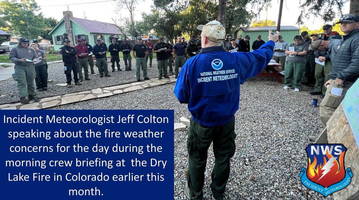
Did You Know?🔥 🔥The National Weather Service creates a variety of forecasts to support those conducting prescribed burns, those fighting wildfires, and those interested in pre-planning - not just during Fire Weather Season! #SouthwestWildfireAwarenessWeek #FireWx #nvwx #azwx

The Los Angeles Fire Department released aerial footage of the devastating impact of the #Palisades Fire on Saturday. #cawx #firewx
The #MonroeCanyonFire remains out of control, scorching nearly 59,000 acres with just 4% containment as of recent reporting. Unfortunately, elevated to critical fire danger is expected to persist through midweek across Utah. #utwx #firewx
Wildfires spread when heat, wind, and dry fuels align. Strong winds push flames, low humidity helps dry vegetation, and heat preheats fuels ahead of the fire. Under the right conditions, fires can spread quickly. Stay aware and prevent fire starts. #FireWX

Quick action from Cal Fire stopped a blaze near a Napa vineyard on Wednesday. Crews say the vineyard itself helped halt the flames. #cawx #firewx
The scenes of homes engulfed in flames in Los Angeles County due to the #Palisades fire are truly heartbreaking. A sobering reminder of the immense toll that the fire is taking on communities. #cawx #firewx
The Madison Fire Department from Rexburg, Idaho, shared footage of their crews assisting with firefighting efforts of the Deer Creek Fire in San Juan County, Utah earlier this week. #utwx #firewx
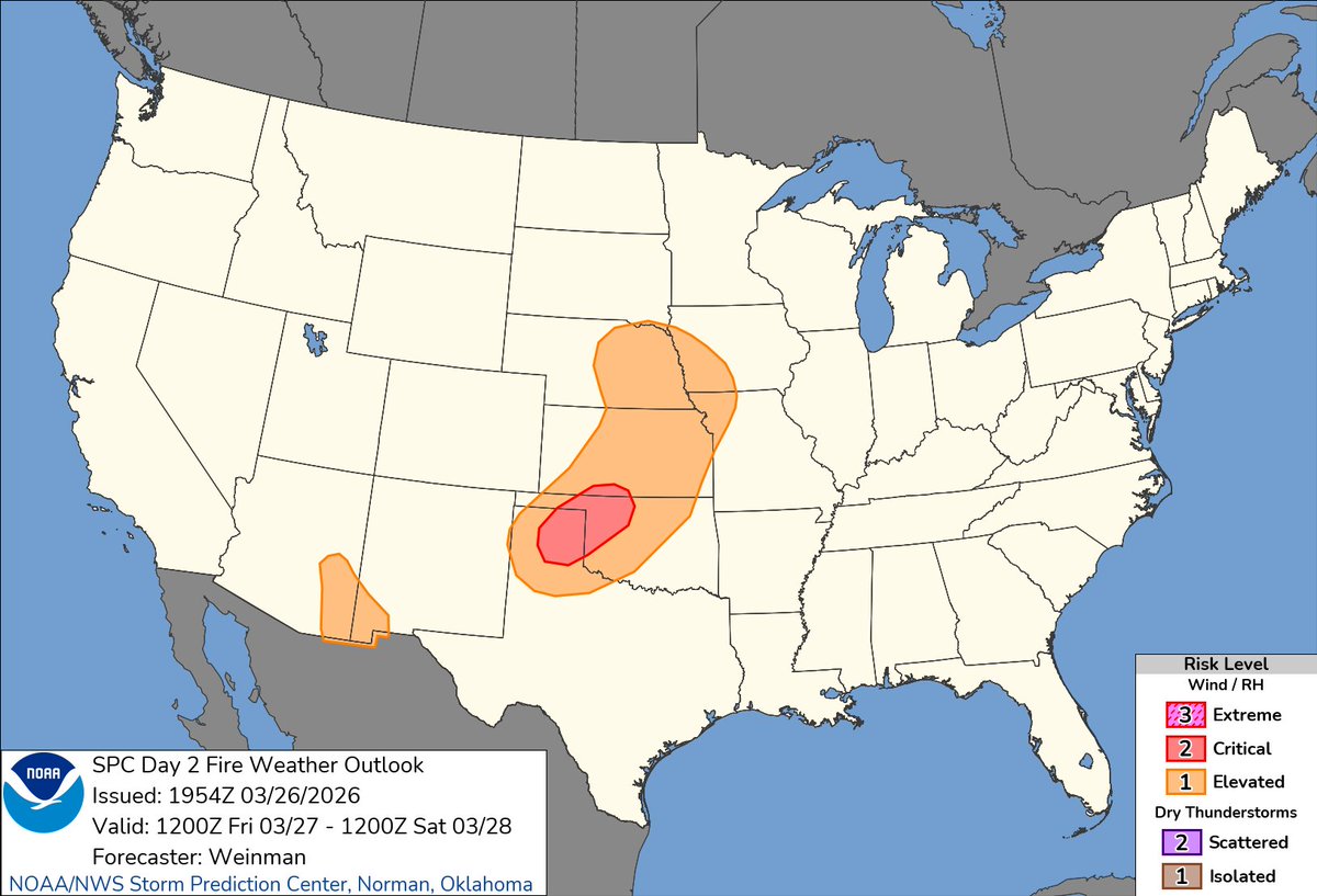
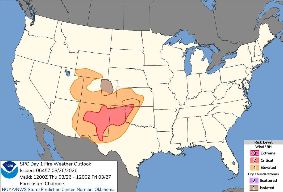
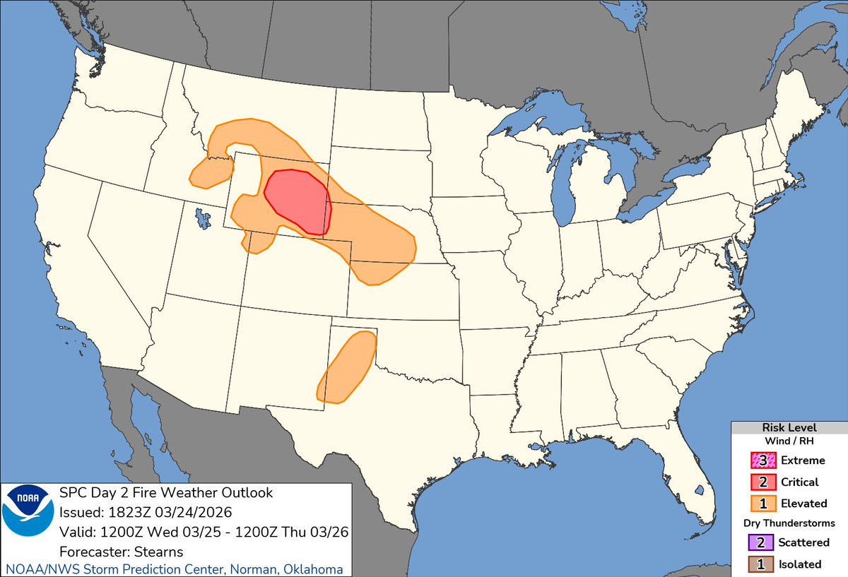
2026-03-25 22:03Z #SPC Day3-8 #FireWX Outlook spc.noaa.gov/products/exper…

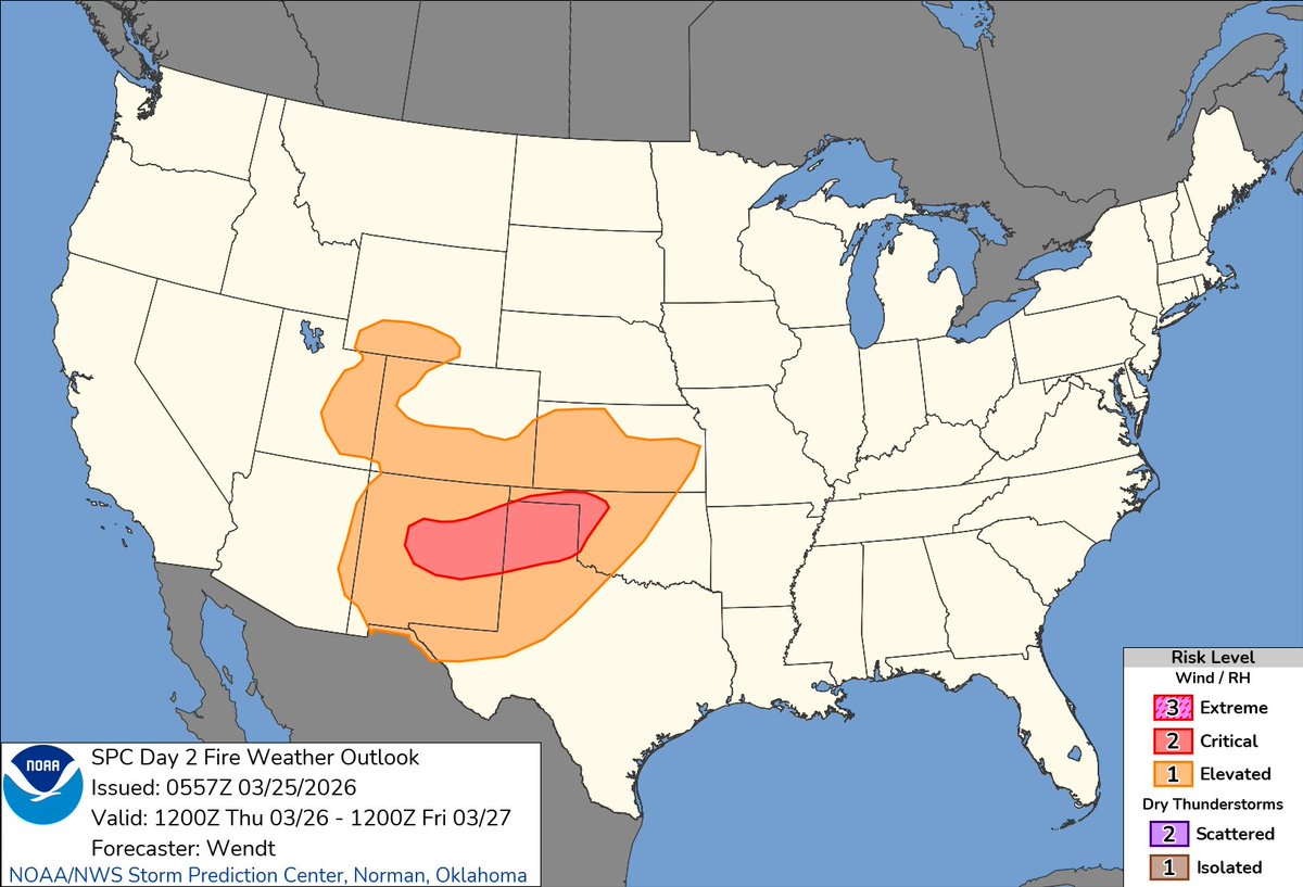
🔥Fire weather conditions are elevated to critical for areas of central New Mexico, West Oklahoma & the Texas Panhandle. 🚩 Red Flag Warnings for central NM, W OK, TX Panhandle. Stay weather alert in #FireWx areas; follow local advisories & prepare. #okwx #txwx #nmwx

2:55pm CDT #SPC Day2 #FireWX Critical: parts of western ok, the eastern tx/ok panhandles, and far south-central ks spc.noaa.gov/products/fire_…
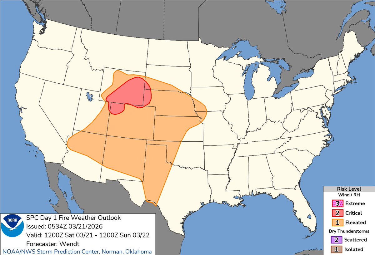
11:59am CDT #SPC Day1 #FireWX Critical: central new mexico into the southern and central plains spc.noaa.gov/products/fire_…

THURSDAY MORNING BURN BAN UPDATE—Pulaski County has now been officially added to the growing list of counties across Arkansas with an active burn ban in place. #arwx #firewx

1:47am CDT #SPC Day1 #FireWX Critical: central new mexico into the southern high plains spc.noaa.gov/products/fire_…
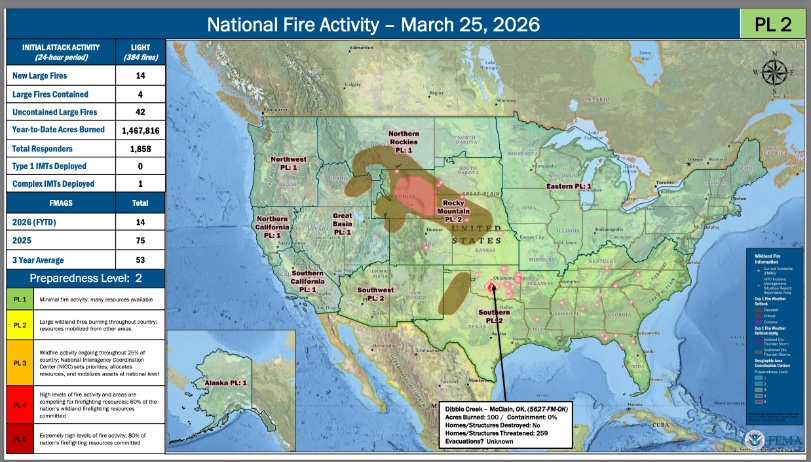
2026-03-25 22:03Z #SPC Day3-8 #FireWX Outlook spc.noaa.gov/products/exper…
Critical fire weather conditions are present today across eastern WY into western NE and far southwest SD. Gusty winds around 20mph and very low humidity near 15% will support rapid fire spread. Elevated conditions also extend into the Rockies and central Plains. #FireWX
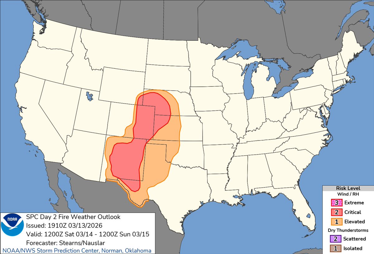
2:44pm CDT #SPC Day2 #FireWX Critical: central new mexico into the texas/oklahoma panhandles and northwest oklahoma spc.noaa.gov/products/fire_…

11:24am CDT #SPC Day1 #FireWX Critical: portions of eastern wyoming into far western nebraska and extreme southwest south dakota spc.noaa.gov/products/fire_…

Did You Know?🔥 🔥The National Weather Service creates a variety of forecasts to support those conducting prescribed burns, those fighting wildfires, and those interested in pre-planning - not just during Fire Weather Season! #SouthwestWildfireAwarenessWeek #FireWx #nvwx #azwx
WILDFIRE DANGER/BURN BANS—The northern half of Arkansas remains in a high risk of wildfire danger. Additionally, burn bans for Arkansas counties continue to expand. No appreciable rainfall chances appear to be in the forecast until early April. #arwx #firewx

12:59am CDT #SPC Day2 #FireWX Critical: central new mexico into the texas/oklahoma panhandles and northwest oklahoma spc.noaa.gov/products/fire_…
12:55am CDT #SPC Day1 #FireWX Critical: parts of central/eastern wyoming into far western nebraska and extreme southwest south dakota spc.noaa.gov/products/fire_…


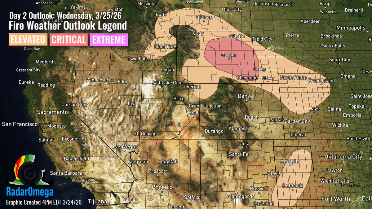
There is a Critical Fire Weather risk Wednesday across central/eastern WY into far western NE. Strong winds (20-25mph), low relative humidity (~10-20%), & very dry fuels will support rapid fire spread. Elevated conditions extend into parts of the central/southern Plains. #FireWX
1:25pm CDT #SPC Day2 #FireWX Critical: parts of central/eastern wyoming into far western nebraska and extreme southwest south dakota spc.noaa.gov/products/fire_…


There is a Critical Fire Weather risk Wednesday across central/eastern WY into far western NE. Strong winds (20-25mph), low relative humidity (~10-20%), & very dry fuels will support rapid fire spread. Elevated conditions extend into parts of the central/southern Plains. #FireWX
PDS Red Flag Warnings adopt critical language to indicate extreme fire weather conditions present. Strong winds, very low humidity, and dry fuels can lead to explosive fire growth. Avoid any activity that could start a fire, conditions are particularly dangerous. #FireWX
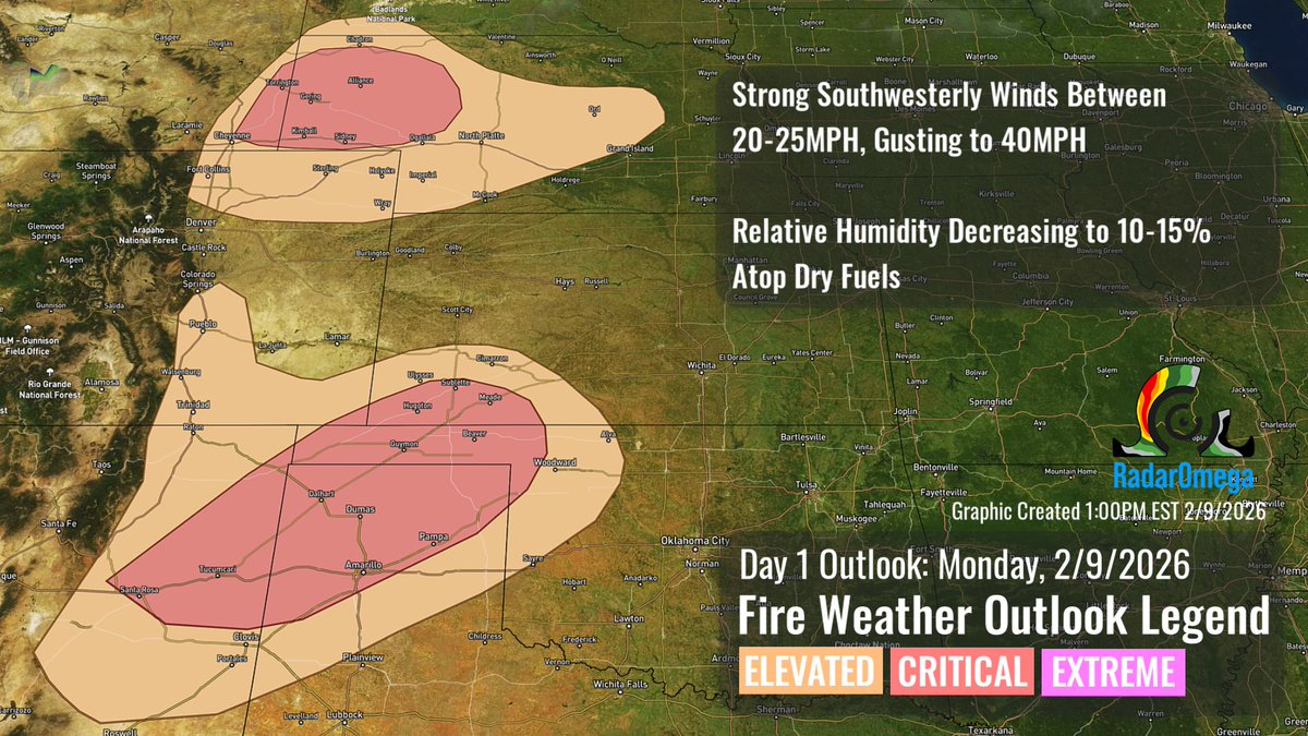
Critical Fire Weather areas have been highlighted for parts of the central & southern Plains today, where strong southwesterly winds and low relative humidity will overlap potentially receptive fuels. Any fires that develop may spread rapidly & be difficult to control. #FireWx

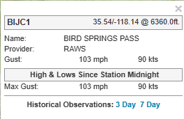
It is currently gusting over 100 miles per hour at Bird Springs Pass in California! This is crazy! #CAwx #FireWX
Weak diurnal flow and high pressure will bring warm days to #SoCal today-Fri. Cooler on Sat Sun-Wed: moderate north winds likely with weak #SantaAnaWinds Tue-Wed. Warm/dry with elevated-locally critical #FireWx conditions.

11:30am CDT #SPC Day1 #FireWX Critical: much of new mexico eastern colorado portions of western nebraska western kansas and west texas spc.noaa.gov/products/fire_…

Praying I don’t have to use this graphic any time soon. (Graphic was made on 1/7/25 before the L.A fires) #Firewx #CAwx

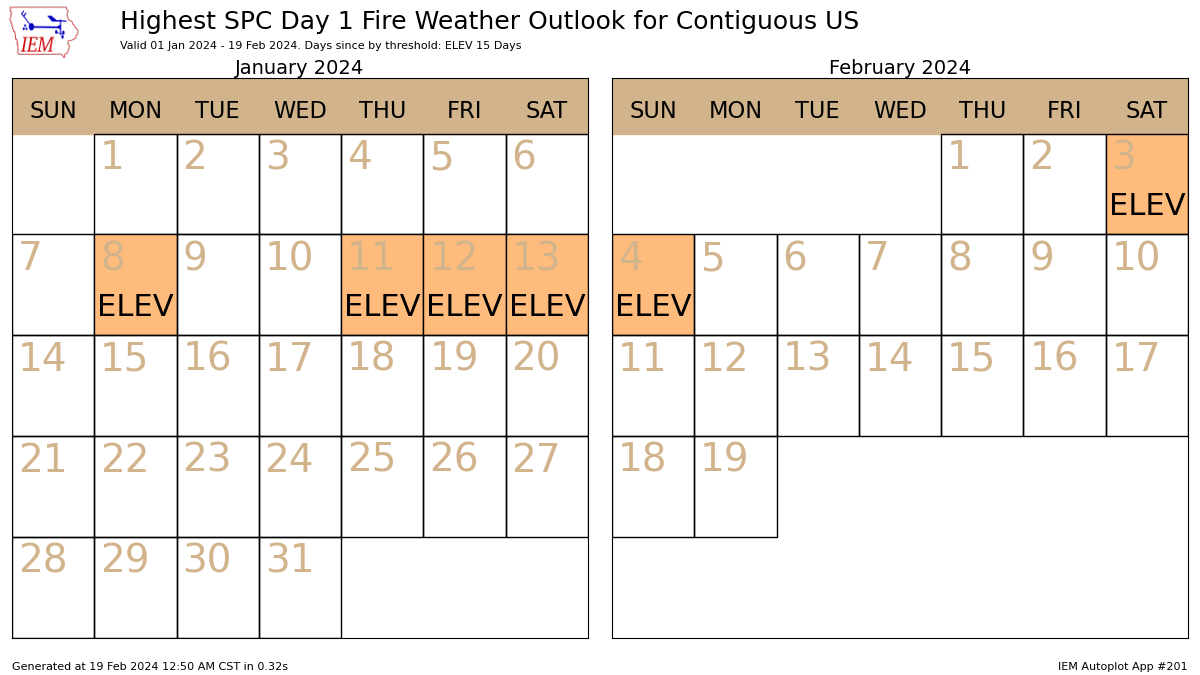
Here's something interesting, fire weather across the CONUS has been abnormally quiet for the Jan 1-Feb 19 period. Only 6 days so far this year have had fire risks, which is one of the lowest days in over 10 years. Certainly not complaining, this is a good thing. #firewx
12:36am CDT #SPC Day1 #FireWX Critical: parts of central/eastern wyoming northwest colorado southwest south dakota western nebraska panhandle spc.noaa.gov/products/fire_…
Here is the latest image of lightning strikes in the state of California since August 1st. Zeus is on the loose. Pretty crazy stuff. #Cawx #Firewx

10:42am CDT #SPC Day1 #FireWX Critical: parts of central/eastern wyoming, northwest colorado, southwest south dakota, western nebraska panhandle spc.noaa.gov/products/fire_…


1:17am CDT #SPC Day1 #FireWX Critical: portions of southeastern wyoming, extreme western nebraska, and extreme northern colorado spc.noaa.gov/products/fire_…

11:24am CDT #SPC Day1 #FireWX Critical: portions of eastern wyoming into far western nebraska and extreme southwest south dakota spc.noaa.gov/products/fire_…

🔥🔥Due to the EXTREME Wildfire Risk today please remember these important wildfire prevention tips. ...Remember wildfires can spread and increase rapidly and be difficult if not impossible to control. 🔥🔥#txwx #FireWX

2:12pm CDT #SPC Day2 #FireWX Critical: much of new mexico, eastern colorado, portions of western nebraska, western kansas, and west texas spc.noaa.gov/products/fire_…

Wildfires spread when heat, wind, and dry fuels align. Strong winds push flames, low humidity helps dry vegetation, and heat preheats fuels ahead of the fire. Under the right conditions, fires can spread quickly. Stay aware and prevent fire starts. #FireWX
We have had 65 Incident Meteorologist missions so far in 2023, with 20 qualified IMETs and 2 trainees currently deployed on missions. We have 26 trainees. 5 trainees have been certified this year, bringing our number of qualified IMETs up to 85! #FireWx
Santa Ana winds will bring fire weather conditions to the region Sun night into Mon. A Fire Weather Watch is in effect 7PM Sun - 6PM Mon for most of LA Co and the E Ventura Valleys. Monitor forecast for Red Flag Warnings, prepare your evacuation kit and report any smoke. #FireWX

Something went wrong.
Something went wrong.
United States Trends
- 1. #911onABC N/A
- 2. #iHeartAwards2026 N/A
- 3. #Dodgers N/A
- 4. #STLCards N/A
- 5. Mike Trout N/A
- 6. #ENHYPEN_IS_7 N/A
- 7. Kevin McGonigle N/A
- 8. Tate Sage N/A
- 9. Druski N/A
- 10. Karl Anthony Towns N/A
- 11. Taylor and Travis N/A
- 12. Astros N/A
- 13. Bolivia N/A
- 14. Hornets N/A
- 15. Duran N/A
- 16. CPAC N/A
- 17. Cluff N/A
- 18. SENPOOL N/A
- 19. Grant Hill N/A
- 20. Mets N/A