#geoapify ผลการค้นหา

Open data enables smarter decisions and faster development. At Geoapify, every API is powered by transparent, reusable data. 💬 How do you leverage open data in your projects? #OpenData #OpenMapping #Geoapify #DataForGood #Developers

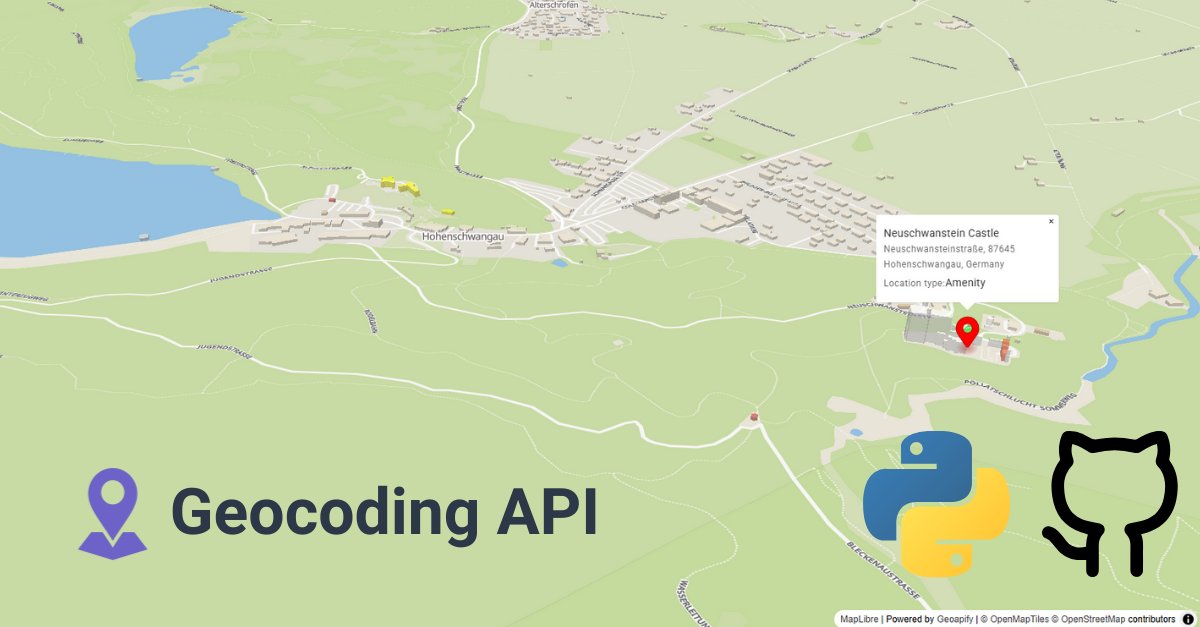
Got a list of GPS coordinates from your fleet? 🗺️ Convert them into addresses automatically with Python + Geoapify API. This Python code sample uses Geoapify’s API to reverse-geocode at scale. #Python #ReverseGeocoding #Geoapify #GeoDev #LogisticsTech #Mapping 🔗…

Ever wondered how far you can get from your house in 30 min 🚴? The Isoline API turns it into a map shape — no guessing, no flat circles. 👉 geoapify.com/isoline-api/ #Geoapify #Isolines #Mapping #Developers #Geospatial

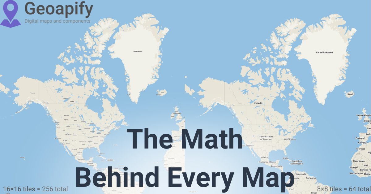
Tiles are the hidden backbone of every web map. 🧩 Each tile = one XYZ coordinate. Put them together → you get the map. 👉 codepen.io/geoapify/pen/z… #Geoapify #Mapping #WebDev #Developers #Geospatial

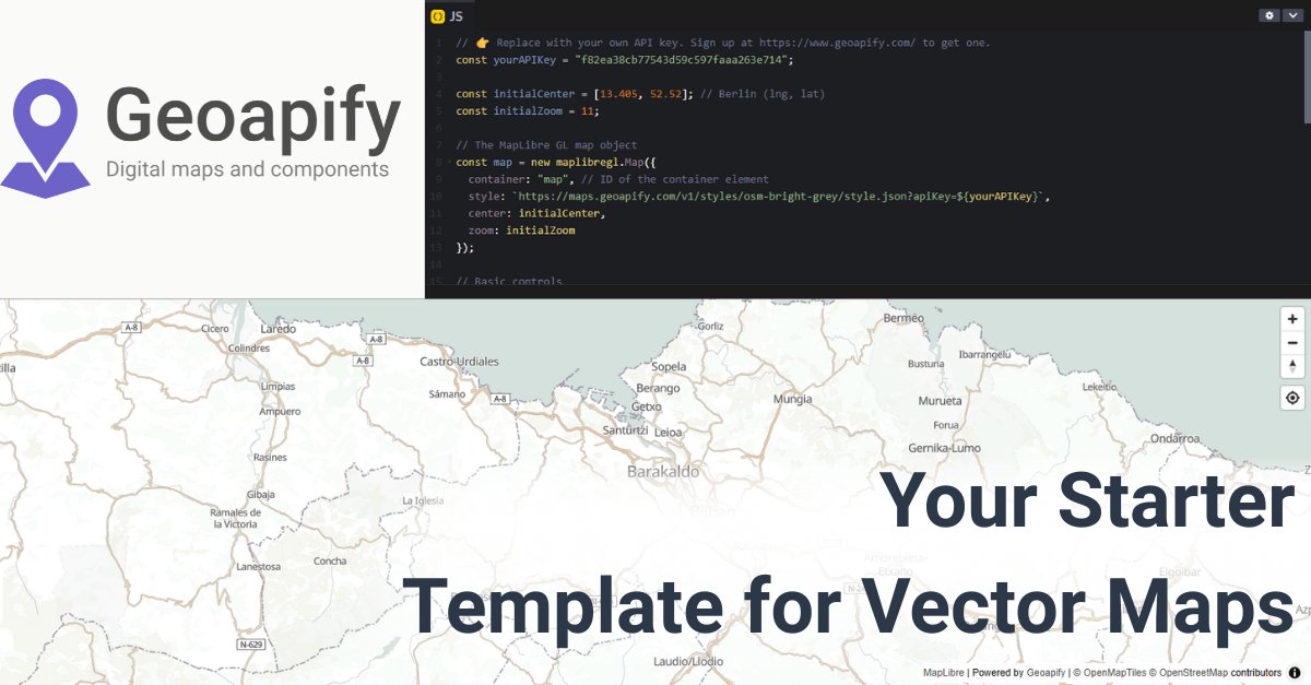
Need a blank-slate map to build on? 🗺️ Fork this MapLibre + Geoapify template: • preset center/zoom • metric scale • geolocate control Go from “hello map” → “prod-ready” fast. 👉 codepen.io/geoapify/pen/G… #Geoapify #MapLibre #WebDev #Mapping #DevTools
From basemaps to vector tiles — every web map runs on XYZ tile coordinates. 🧩 Understand zoom levels → build smarter, faster maps. 👉 dev.to/geoapify-maps-… #Geoapify #Mapping #Developers #WebDev #Geospatial
Need delivery zones, service areas, or walkability maps? The Isoline API calculates travel-time & distance areas from real routing data. 👉 codepen.io/geoapify/pen/B… #Geoapify #Isolines #Routing #Mapping #Developers

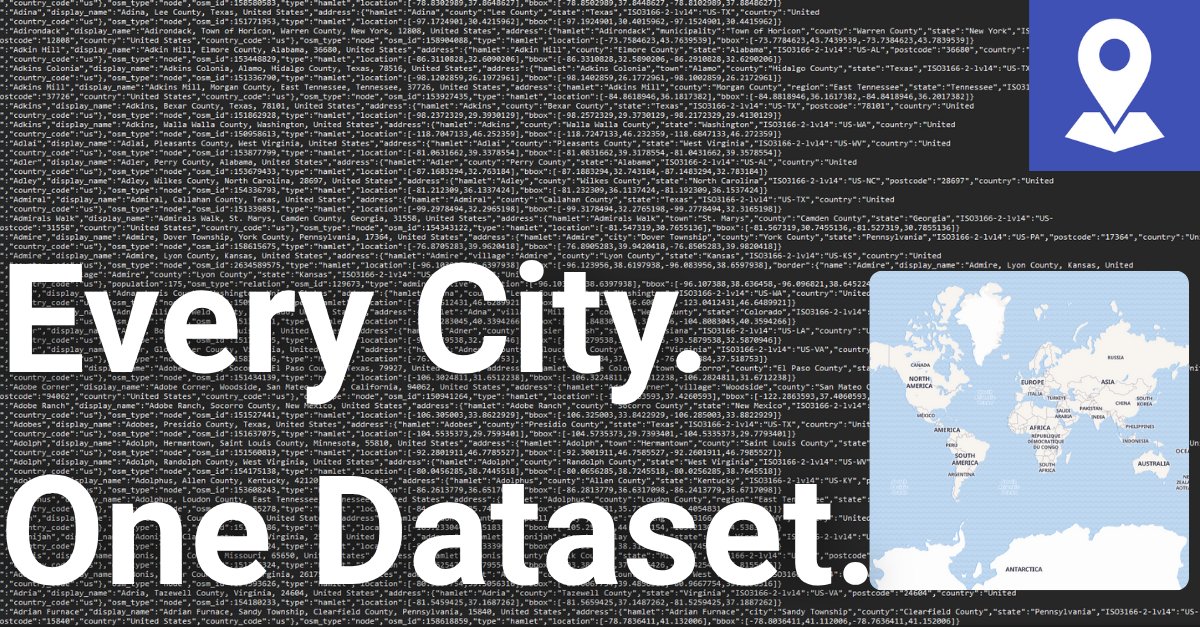
Your world map just got smarter. 🌎 The Cities & Towns dataset has been refreshed — from megacities to the smallest villages. Download it free → geoapify.com/download-all-t… #Geoapify #OpenData #Geospatial #Mapping #Developers

New in Places API → Memorial & Funeral Services category. Query cemeteries, memorials, funeral homes, and related POIs worldwide. 👉 geoapify.com/places-api/ #Geoapify #PlacesAPI #Geospatial #Mapping #Developers

Learning Python and need a real-world example? Here’s how to reverse-geocode coordinates using Geoapify API: 📍 Read coordinates from a file 🔄 Call a real geocoding API 💾 Write structured results to NDJSON #Python #ReverseGeocoding #Geoapify #GeoDev #APIs #CodingTutorial 🔗…

Stop scraping random city lists. 😅 Get clean, structured, up-to-date city data from Geoapify, based on OpenStreetMap tags & references — available in CSV, GeoJSON, and Shapefile formats. 👉 geoapify.com/download-all-t… #Geoapify #OpenData #OSM #Developers #Geospatial

Need style control in Leaflet? 🎨 Vector maps let you tweak colors, fonts, layers — without redrawing tiles. Here’s a working demo with Geoapify + maplibre-gl-leaflet: 👉 codepen.io/geoapify/pen/v… #DevTools #Geoapify #Geospatial

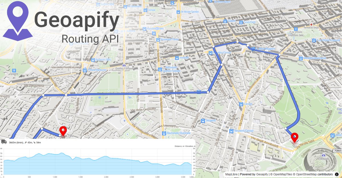
What’s the fastest way to deliver 10 pizzas with 3 scooters? 🍕🛵 First, you need the travel times & distances between all stops — that’s what the Route Matrix API provides. It’s the core data behind routing & optimization. 👉 geoapify.com/route-matrix-a… #Geoapify #APIs #Routing…

Why does a map look sharper as you zoom? 🗺️ Because zoom levels swap out a grid of XYZ tiles behind the scenes. See it in action → codepen.io/geoapify/pen/z… #Geoapify #Mapping #Geospatial #WebDev #Developers

Fresh city data → cleaner apps. 🌍 The Global Cities & Towns dataset now includes updated coordinates, names, and populations — ready to use. 👉 geoapify.com/download-all-t… #Geoapify #OpenData #Geospatial #Developers #Mapping

Leaflet + Geoapify Places API demo: pick categories, move the map, and watch markers stream in. Try it → codepen.io/geoapify/pen/M… (via @CodePen) #Leaflet #Geoapify #WebMapping #OpenStreetMap #JavaScript

What’s faster across the city — 🚲 bike or 🚗 car? Play with modes in the Routing API playground to see the difference. 👉 apidocs.geoapify.com/playground/rou… #DevTools #Geoapify #Mapping #Coding #APIs

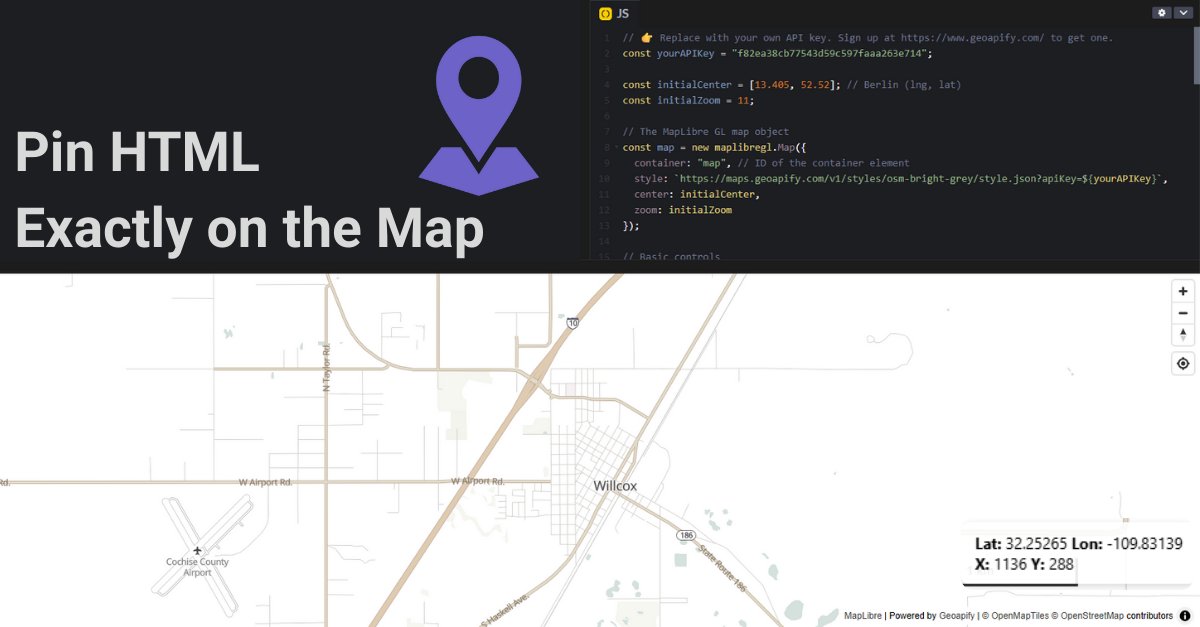
Stop guessing overlay positions ✋ Use MapLibre’s map.project() to anchor DOM elements exactly where your features are. Example 👉 codepen.io/geoapify/pen/x… #Geoapify #MapLibre #WebDev #GIS #Developers
Open data enables smarter decisions and faster development. At Geoapify, every API is powered by transparent, reusable data. 💬 How do you leverage open data in your projects? #OpenData #OpenMapping #Geoapify #DataForGood #Developers
Got a list of GPS coordinates from your fleet? 🗺️ Convert them into addresses automatically with Python + Geoapify API. This Python code sample uses Geoapify’s API to reverse-geocode at scale. #Python #ReverseGeocoding #Geoapify #GeoDev #LogisticsTech #Mapping 🔗…
Stop scraping random city lists. 😅 Get clean, structured, up-to-date city data from Geoapify, based on OpenStreetMap tags & references — available in CSV, GeoJSON, and Shapefile formats. 👉 geoapify.com/download-all-t… #Geoapify #OpenData #OSM #Developers #Geospatial
Learning Python and need a real-world example? Here’s how to reverse-geocode coordinates using Geoapify API: 📍 Read coordinates from a file 🔄 Call a real geocoding API 💾 Write structured results to NDJSON #Python #ReverseGeocoding #Geoapify #GeoDev #APIs #CodingTutorial 🔗…
Loading lots of places on your map? Don’t hit the rate limits! 🚦 Learn how to run chunked & rate-limited place searches in Leaflet using the Geoapify Places API 👇 👉 dev.to/geoapify-maps-… #Leaflet #MapsAPI #Geoapify #WebDev #JavaScript #OpenStreetMap

Tiles are the hidden backbone of every web map. 🧩 Each tile = one XYZ coordinate. Put them together → you get the map. 👉 codepen.io/geoapify/pen/z… #Geoapify #Mapping #WebDev #Developers #Geospatial
Building a “Find Nearby” feature? Here’s how to do it with Leaflet + Geoapify Places API — full tutorial 👇 dev.to/geoapify-maps-… #GIS #Geoapify #LeafletJS #WebDev #Coding #API #Geolocation

Leaflet + Geoapify Places API demo: pick categories, move the map, and watch markers stream in. Try it → codepen.io/geoapify/pen/M… (via @CodePen) #Leaflet #Geoapify #WebMapping #OpenStreetMap #JavaScript
Looking for vector maps in Leaflet? 🗺️ Raster tiles feel outdated. Switch to Geoapify vector maps with maplibre-gl-leaflet: ✔️ Smooth zoom ✔️ Modern styling ✔️ Faster rendering See it live 👉 codepen.io/geoapify/pen/v… #Leaflet #VectorMaps #Geoapify #JavaScript

Share travel-time maps in seconds. ⏱️ Our Isoline API Playground now accepts smart parameters right in the URL. Example (15 min drive from Oslo): 👉 apidocs.geoapify.com/playground/iso… #Isolines #APIs #Geoapify #geospatial

📍 100+ coordinates to reverse-geocode? No problem. Python + ThreadPoolExecutor = parallel processing with Geoapify, respecting API limits. 🔁 Multi-threaded ⏱️ Fast batch geocoding 🧠 Smart sleep cycles to avoid 429s #Python #ReverseGeocoding #Geoapify #GeoDev…

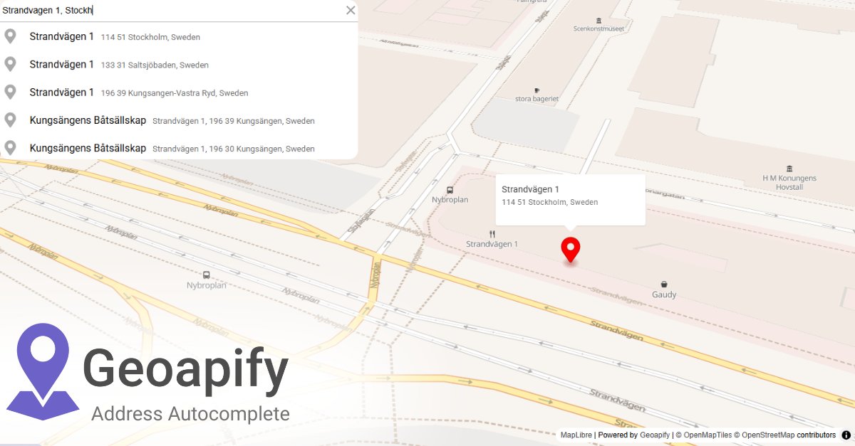
From Tokyo to São Paulo to Berlin — address formats differ. Autocomplete API normalizes input with global coverage + local rules. 🌍 👉 apidocs.geoapify.com/playground/geo… #Geoapify #Geocoding #WebDev #DataQuality #APIs

Your world map just got smarter. 🌎 The Cities & Towns dataset has been refreshed — from megacities to the smallest villages. Download it free → geoapify.com/download-all-t… #Geoapify #OpenData #Geospatial #Mapping #Developers
What’s faster across the city — 🚲 bike or 🚗 car? Play with modes in the Routing API playground to see the difference. 👉 apidocs.geoapify.com/playground/rou… #DevTools #Geoapify #Mapping #Coding #APIs
Lat/lon bounds → pixel width & height. This demo shows how to calculate overlay dimensions from map zoom + viewport size. 👉 codepen.io/geoapify/pen/d… #Geoapify #MapLibre #WebDev #Developers #GIS

Fresh city data → cleaner apps. 🌍 The Global Cities & Towns dataset now includes updated coordinates, names, and populations — ready to use. 👉 geoapify.com/download-all-t… #Geoapify #OpenData #Geospatial #Developers #Mapping
What’s the fastest way to deliver 10 pizzas with 3 scooters? 🍕🛵 First, you need the travel times & distances between all stops — that’s what the Route Matrix API provides. It’s the core data behind routing & optimization. 👉 geoapify.com/route-matrix-a… #Geoapify #APIs #Routing…
Need delivery zones, service areas, or walkability maps? The Isoline API calculates travel-time & distance areas from real routing data. 👉 codepen.io/geoapify/pen/B… #Geoapify #Isolines #Routing #Mapping #Developers
New in Places API → Memorial & Funeral Services category. Query cemeteries, memorials, funeral homes, and related POIs worldwide. 👉 geoapify.com/places-api/ #Geoapify #PlacesAPI #Geospatial #Mapping #Developers
Why does a map look sharper as you zoom? 🗺️ Because zoom levels swap out a grid of XYZ tiles behind the scenes. See it in action → codepen.io/geoapify/pen/z… #Geoapify #Mapping #Geospatial #WebDev #Developers
Ever wondered how far you can get from your house in 30 min 🚴? The Isoline API turns it into a map shape — no guessing, no flat circles. 👉 geoapify.com/isoline-api/ #Geoapify #Isolines #Mapping #Developers #Geospatial
Need delivery zones, service areas, or walkability maps? The Isoline API calculates travel-time & distance areas from real routing data. 👉 codepen.io/geoapify/pen/B… #Geoapify #Isolines #Routing #Mapping #Developers
Need a blank-slate map to build on? 🗺️ Fork this MapLibre + Geoapify template: • preset center/zoom • metric scale • geolocate control Go from “hello map” → “prod-ready” fast. 👉 codepen.io/geoapify/pen/G… #Geoapify #MapLibre #WebDev #Mapping #DevTools
New in Places API → Memorial & Funeral Services category. Query cemeteries, memorials, funeral homes, and related POIs worldwide. 👉 geoapify.com/places-api/ #Geoapify #PlacesAPI #Geospatial #Mapping #Developers
Open data enables smarter decisions and faster development. At Geoapify, every API is powered by transparent, reusable data. 💬 How do you leverage open data in your projects? #OpenData #OpenMapping #Geoapify #DataForGood #Developers
Need style control in Leaflet? 🎨 Vector maps let you tweak colors, fonts, layers — without redrawing tiles. Here’s a working demo with Geoapify + maplibre-gl-leaflet: 👉 codepen.io/geoapify/pen/v… #DevTools #Geoapify #Geospatial
Got a list of GPS coordinates from your fleet? 🗺️ Convert them into addresses automatically with Python + Geoapify API. This Python code sample uses Geoapify’s API to reverse-geocode at scale. #Python #ReverseGeocoding #Geoapify #GeoDev #LogisticsTech #Mapping 🔗…
Your world map just got smarter. 🌎 The Cities & Towns dataset has been refreshed — from megacities to the smallest villages. Download it free → geoapify.com/download-all-t… #Geoapify #OpenData #Geospatial #Mapping #Developers
Instead of cleaning addresses after they’re stored, validate them while typing. Address Autocomplete API → structured results (street, city, postcode, country). 👉 apidocs.geoapify.com/playground/geo… #Geoapify #APIs #WebDev
Fresh city data → cleaner apps. 🌍 The Global Cities & Towns dataset now includes updated coordinates, names, and populations — ready to use. 👉 geoapify.com/download-all-t… #Geoapify #OpenData #Geospatial #Developers #Mapping
What’s the fastest way to deliver 10 pizzas with 3 scooters? 🍕🛵 First, you need the travel times & distances between all stops — that’s what the Route Matrix API provides. It’s the core data behind routing & optimization. 👉 geoapify.com/route-matrix-a… #Geoapify #APIs #Routing…
Why does a map look sharper as you zoom? 🗺️ Because zoom levels swap out a grid of XYZ tiles behind the scenes. See it in action → codepen.io/geoapify/pen/z… #Geoapify #Mapping #Geospatial #WebDev #Developers
Need all the world’s cities, towns, and villages in one dataset? 🌍 Download structured, ready-to-use data for any country — free from Geoapify. 👉 geoapify.com/download-all-t… #Geoapify #OpenData #Developers #Geospatial #DataScience
ETAs without traffic context = misleading. 🛑 The Geoapify Routing API simulates rush-hour conditions to provide more realistic travel times than “empty road” routing. Try it here 👉 apidocs.geoapify.com/playground/rou… #Geoapify #Routing #WebDev #APIs #Geospatial
What’s faster across the city — 🚲 bike or 🚗 car? Play with modes in the Routing API playground to see the difference. 👉 apidocs.geoapify.com/playground/rou… #DevTools #Geoapify #Mapping #Coding #APIs
Stop guessing overlay positions ✋ Use MapLibre’s map.project() to anchor DOM elements exactly where your features are. Example 👉 codepen.io/geoapify/pen/x… #Geoapify #MapLibre #WebDev #GIS #Developers
From basemaps to vector tiles — every web map runs on XYZ tile coordinates. 🧩 Understand zoom levels → build smarter, faster maps. 👉 dev.to/geoapify-maps-… #Geoapify #Mapping #Developers #WebDev #Geospatial
Leaflet + Geoapify Places API demo: pick categories, move the map, and watch markers stream in. Try it → codepen.io/geoapify/pen/M… (via @CodePen) #Leaflet #Geoapify #WebMapping #OpenStreetMap #JavaScript
🌍 Only want reverse-geocoding results from one country? No problem. This Python reverse geocode code sample lets you filter by country code (US , DE , FR, ...) so you don’t get noisy results from across the border. #Python #ReverseGeocoding #Geoapify #GeoDev #GIS…
Tiles are the hidden backbone of every web map. 🧩 Each tile = one XYZ coordinate. Put them together → you get the map. 👉 codepen.io/geoapify/pen/z… #Geoapify #Mapping #WebDev #Developers #Geospatial
Something went wrong.
Something went wrong.
United States Trends
- 1. Jokic 25.9K posts
- 2. Lakers 52.6K posts
- 3. Epstein 1.62M posts
- 4. #AEWDynamite 50.2K posts
- 5. #River 4,934 posts
- 6. Nemec 3,333 posts
- 7. Clippers 14.4K posts
- 8. Shai 16.2K posts
- 9. #ReasonableDoubtHulu N/A
- 10. Thunder 40.8K posts
- 11. #NJDevils 3,114 posts
- 12. Markstrom 1,255 posts
- 13. #Blackhawks 1,605 posts
- 14. Ty Lue 1,137 posts
- 15. Nemo 8,558 posts
- 16. Mikey 71.6K posts
- 17. Lafferty N/A
- 18. Rory 8,038 posts
- 19. Joker 26.5K posts
- 20. Jordan Miller N/A