
Geoapify
@geoapify
Location Platform to create location-aware apps! Try our APIs, online tools, tutorials. #maps #maptiles #geocoding #routing #isolines #routeoptimization
คุณอาจชื่นชอบ


We believe openness fuels progress, and we’re proud to power developers with transparent, reusable data. 💬 Which open-source tool can you not live without? #Geoapify #OpenSource #OpenMapping #Developers #GeoCommunity
Ever tried merging multiple “city lists”? You end up with duplicates, missing towns, and IDs that make no sense. 😩 OSM localities + Geoapify = clean, consistent global coverage — cities, towns, villages, hamlets. 👉 dev.to/geoapify-maps-… #Geoapify #Developers #Data…

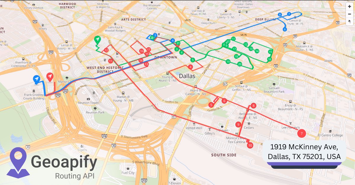
@geoapify/route-planner-sdk → v1.1.7 🚀 Now supports optional click-event handling: timeline.on('onWaypointClick', (waypoint, agentIndex) => { console.log('Clicked waypoint:', waypoint, 'Agent:', agentIndex); }); Try it 👉 npmjs.com/package/@geoap… #Geoapify #Routing #WebDev
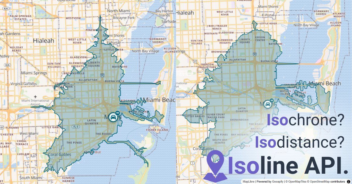
Circles are a lie. Travel time depends on roads, traffic & transport mode. The Isoline API calculates zones from real routing data → accurate reach maps. 👉 geoapify.com/isoline-api/ #Geoapify #Isolines #Geospatial #Routing #Developers
Working with place data? OSM localities (city/town/village/hamlet) + Geoapify APIs = clean, consistent global coverage. Full guide → dev.to/geoapify-maps-… #Geoapify #Developers #GIS #OpenData #Mapping

Geoapify’s Isolines API helps you map reachability for logistics, service planning, and more. 💬 What insights could travel-time maps unlock for your product? #Geoapify #IsochroneAPI #IsolineAPI #Reachability #GIS
Updated: @geoapify/un-locode 🚢🌍 Our JS library for working with UN/LOCODE now includes a refreshed dataset + improved structure for logistics & supply-chain apps. Check it out → npmjs.com/package/@geoap… #Geoapify #Logistics #Shipping #Data #Developers #JavaScript #NPM…
Want to master geospatial data in #Python? Explore below our hands-on guide covering 12 libraries & how to combine them with Geoapify services for mapping, routing, isochrones, and more: #Geoapify #Coding #GeospatialAnalysis #APIs geoapify.com/python-geospat…

Open data enables smarter decisions and faster development. At Geoapify, every API is powered by transparent, reusable data. 💬 How do you leverage open data in your projects? #OpenData #OpenMapping #Geoapify #DataForGood #Developers

Got a list of GPS coordinates from your fleet? 🗺️ Convert them into addresses automatically with Python + Geoapify API. This Python code sample uses Geoapify’s API to reverse-geocode at scale. #Python #ReverseGeocoding #Geoapify #GeoDev #LogisticsTech #Mapping 🔗…

Stop scraping random city lists. 😅 Get clean, structured, up-to-date city data from Geoapify, based on OpenStreetMap tags & references — available in CSV, GeoJSON, and Shapefile formats. 👉 geoapify.com/download-all-t… #Geoapify #OpenData #OSM #Developers #Geospatial

Learning Python and need a real-world example? Here’s how to reverse-geocode coordinates using Geoapify API: 📍 Read coordinates from a file 🔄 Call a real geocoding API 💾 Write structured results to NDJSON #Python #ReverseGeocoding #Geoapify #GeoDev #APIs #CodingTutorial 🔗…

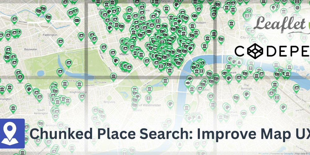
Loading lots of places on your map? Don’t hit the rate limits! 🚦 Learn how to run chunked & rate-limited place searches in Leaflet using the Geoapify Places API 👇 👉 dev.to/geoapify-maps-… #Leaflet #MapsAPI #Geoapify #WebDev #JavaScript #OpenStreetMap
Boost your e-commerce checkout! 🛒 Use Geoapify Geocoding API to convert user-entered addresses to latitude/longitude in real-time: ➡️ Faster delivery planning ➡️ Fewer failed shipments ➡️ Happier customers Try it → geoapify.com/geocoding-api/ #Geocoding #EcommerceTech…

Tiles are the hidden backbone of every web map. 🧩 Each tile = one XYZ coordinate. Put them together → you get the map. 👉 codepen.io/geoapify/pen/z… #Geoapify #Mapping #WebDev #Developers #Geospatial

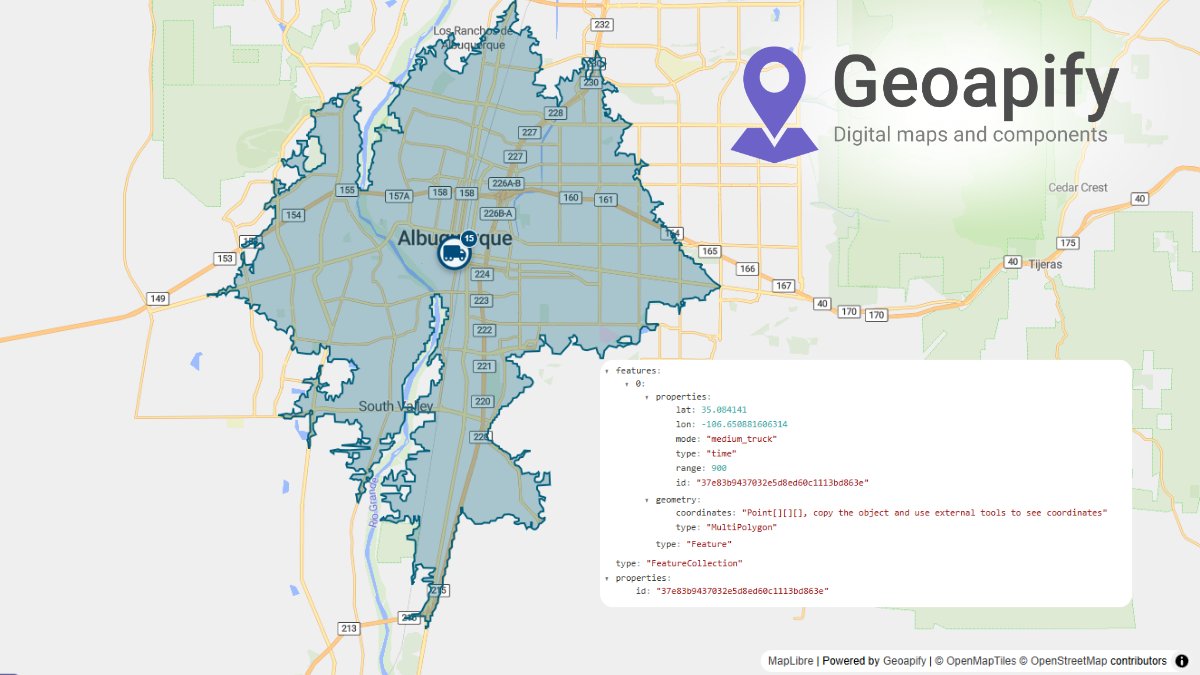
From logistics to real estate and urban planning – Geoapify Isoline API helps you: • Define delivery zones 🚚 • Analyze accessibility 🏥 • Plan service coverage 🏢 All in one easy API. Learn more → geoapify.com/isoline-api/ #IsolineAPI #Accessibility #UrbanPlanning…
Building a “Find Nearby” feature? Here’s how to do it with Leaflet + Geoapify Places API — full tutorial 👇 dev.to/geoapify-maps-… #GIS #Geoapify #LeafletJS #WebDev #Coding #API #Geolocation
dev.to
How to Query and Display Nearby Places on a Leaflet Map with the Geoapify Places API
In this tutorial, you’ll learn how to use the Geoapify Places API with Leaflet to display nearby...
Leaflet + Geoapify Places API demo: pick categories, move the map, and watch markers stream in. Try it → codepen.io/geoapify/pen/M… (via @CodePen) #Leaflet #Geoapify #WebMapping #OpenStreetMap #JavaScript

Looking for vector maps in Leaflet? 🗺️ Raster tiles feel outdated. Switch to Geoapify vector maps with maplibre-gl-leaflet: ✔️ Smooth zoom ✔️ Modern styling ✔️ Faster rendering See it live 👉 codepen.io/geoapify/pen/v… #Leaflet #VectorMaps #Geoapify #JavaScript

Share travel-time maps in seconds. ⏱️ Our Isoline API Playground now accepts smart parameters right in the URL. Example (15 min drive from Oslo): 👉 apidocs.geoapify.com/playground/iso… #Isolines #APIs #Geoapify #geospatial


United States เทรนด์
- 1. Zeraora 10.7K posts
- 2. Peggy 28.7K posts
- 3. Berseria 3,465 posts
- 4. #FaithFreedomNigeria 1,553 posts
- 5. Cory Mills 22.6K posts
- 6. Dearborn 347K posts
- 7. Good Wednesday 35.8K posts
- 8. Randy Jones N/A
- 9. Luxray 1,814 posts
- 10. Sonic 06 1,548 posts
- 11. #Wednesdayvibe 2,597 posts
- 12. #wednesdaymotivation 7,485 posts
- 13. $NVDA 42.6K posts
- 14. Xillia 2 N/A
- 15. International Men's Day 69.7K posts
- 16. Hump Day 18.7K posts
- 17. Cleo 3,061 posts
- 18. Tom Steyer N/A
- 19. Zestiria N/A
- 20. #CurrysPurpleFriday 9,550 posts


Something went wrong.
Something went wrong.