

GeoArrow enables a 30x speedup of reading @GeoPackage1 and @flatgeobuf from GDAL into @geopandas!


What would a foundational model of the Earth look like? Here's my conversation with @brunosan, who started the Clay foundation -which just released their v1 of a "Foundational model of Earth" to go into what that means Watch: youtu.be/teH_JwhYMxU

Visualising Meteorological Data with @QGIS Don't miss this 2-day hands on session hosted by @lutraconsulting and #thrivegeo from 27-28 June and learn how to use the latest tools for meteorological data in #QGIS! lutraconsulting.co.uk/training/meteo…
Listen in for a discussion on what @GeoParquet solves and why you should (or shouldn't) consider using it! We cover how GeoParquet is cloud native, how its compression makes reading and writing faster, and how it integrates with GeoArrow for fast in-memory computing.

We are excited to announce that @OPENGISch has upgraded to gold sponsor of FOSS4GE!🤩 They provide a powerful and efficient way to manage your data on the go.👏 Check them out at👉opengis.ch #FOSS4GE2024 #FOSS4GE #FOSS4G


I'm presenting at #Locate24 Conference in Sydney with a talk giving a history of Digital Earth. My talk is on Wednesday afternoon, at 2.15 pm. locate.geospatialcouncil.org.au Can't wait to catch up with folks!

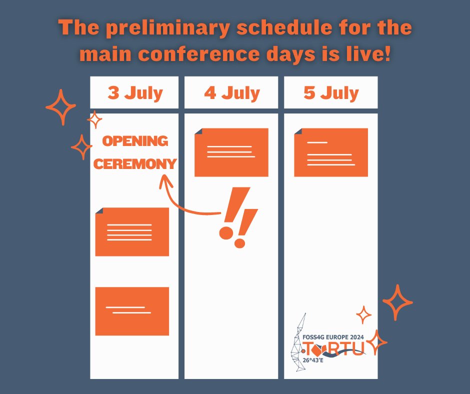
🎉We are happy to announce the release of the preliminary schedule for the main conference days, 3-5 July 2024!🗓️ 📋Please note that there may still be some changes. 📌You can explore the schedule in more detail by visiting 2024.europe.foss4g.org/schedule/talks/

#QGIS Pro Tip: You can use the 'Execute SQL' processing algorithm to run SQL queries on ANY vector layer within QGIS. Here's an example of calculating group statistics on a vector layer. This also allows you to run SQL queries in a model.

Had a really nice conversation with @MaxLenormand for his wonderful @MindsBehindMaps podcast. If you’re into maps, subscribe now or you’re missing out a lot! Enjoy the episode, and any comments are most welcome. 🙏
Here's my conversation with @mourner on the story behind @LeafletJS, arguably the simplest mapping library and used on maps all over the Internet today We talk about what makes maps complicated, keeping code simple, open source & life in Ukraine Watch: youtu.be/k7aVBINDRJg
The way you talk about your geospatial skills is costing you money! 👇 @briantimoney nailed this one! mapscaping.com/podcast/way-yo…

We also welcome OGC Innovation Days as a parallel event during our conference (1 - 2 July)! 🙌 👉 Get your tickets here: pretix.eu/foss4ge2024/ta…

Registration is now open for OGC Innovation Days Europe! With the theme "Climate and Disaster Resilience, One Health, and Data Spaces," iDays seeks to connect technology with policy. It will be held July 1-2 in conjunction with @foss4ge in Tartu, Estonia bit.ly/3vcIgKu


Thank you, @MaxLenormand, for the opportunity to talk about my open source #geospatial journey @MindsBehindMaps. Check it out 👇 youtu.be/H2v0xQylrUI
youtube.com
YouTube
Qiusheng Wu: Building & Sharing Open Source Software
Here's my conversation with @giswqs about building and, just as importantly, sharing & teaching around open source software We dive into Qiusheng's story, how we started developing open source software and how he shares it to the world Watch: youtu.be/H2v0xQylrUI

If you want to learn how to make this map using elevation and river data from HydroSHEDS, you need to check out my tutorial here: 🔗youtu.be/fIOCVCxh2B8
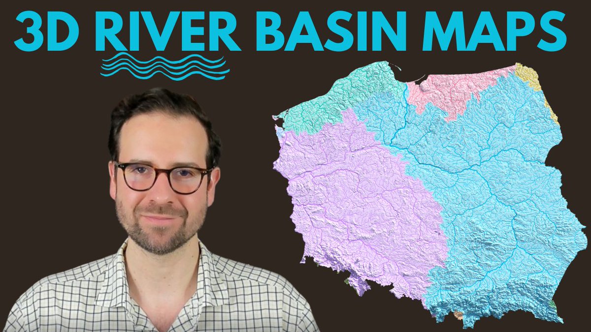
👋🏻Hey, map fans! What if you could see South America’s river basins in 3D? That’s what I did with my new map: the 3D river basin map of South America. This map shows you how each river has its own color and width, based on the basin it flows in and its size. 💧 You can admire…

The submission of travel grant applications has opened!🎊 🗓️Travel grants are open to residents of European countries. The deadline is on the 31st of March! To learn more about the travel grant or to submit your application, check our website! 👉2024.europe.foss4g.org/registration/t…


Today, 14 students of the module Planning for Urban #ClimateAdaptation of the @ihedelft MSc program on Water & Sustainable Development have received their official #qgis certificate! Besides analysis with QGIS they presented their results with @felt and @CesiumJS Stories.


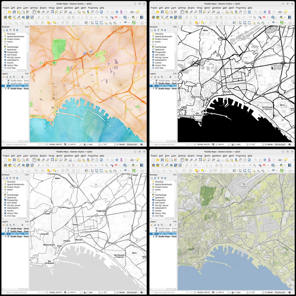
🌍 Elevate Your Maps w/ Stadia Maps & @qgis! 🚀 Dive into our tutorial to seamlessly blend @stamen styles into your projects. Perfect for GIS pros, researchers, & hobbyists. Unlock cartographic storytelling today! Tutorial: docs.stadiamaps.com/tutorials/how-… #GIS #Mapping #QGIS #DataViz

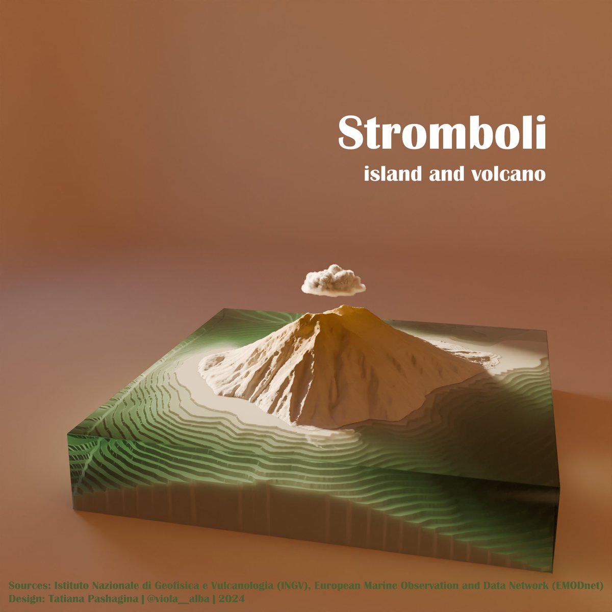
#MapPromptMonday 🗺️ Week 7 "Islands". A model of #Stromboli volcano island made of DEM ⛰️🌋and bathymetry 🌊🌊in #Blender Seems good enough for an experiment, I think😊 Looks like a vinyl record cover to me💿🎙️ #QGIS #gis #b3d #3dviz

Yo dawg I heard you like maps so I made my map store into a map office so I can map while I map #gis #gischat


Explore the world of map design with our cartographer @mamataakella in this wonderful episode of the @MapScaping podcast! Don't miss out—give it a listen. 🎧👇🏻
. @mamataakella makes beautiful maps using @felt and this is how she does it! mapscaping.com/podcast/making…
I will be teaching a geographic software design course at the University of Tennessee this semester! 🌍📐 The lectures will be recorded and made freely available on YouTube. 🎥🆓 Three videos will be uploaded per week. Please follow if you are interested in developing open-source…


United States เทรนด์
- 1. Brian Kelly 15.1K posts
- 2. #VERZUZ 54.6K posts
- 3. Yamamoto 66.5K posts
- 4. Birdman 14.6K posts
- 5. No Limit 35.2K posts
- 6. Colorado 34.3K posts
- 7. Mia X 580K posts
- 8. Cash Money 29.6K posts
- 9. Deion 2,001 posts
- 10. Wayne 37.4K posts
- 11. Salter 1,709 posts
- 12. Texas A&M 14.1K posts
- 13. Death Valley 5,479 posts
- 14. Michigan 38.9K posts
- 15. Coach Prime 1,365 posts
- 16. #GoBlue 3,645 posts
- 17. Turk 575K posts
- 18. Aggies 5,277 posts
- 19. Mizkif 17.2K posts
- 20. Baton Rouge 3,105 posts
Something went wrong.
Something went wrong.