#geospatialtechnology search results


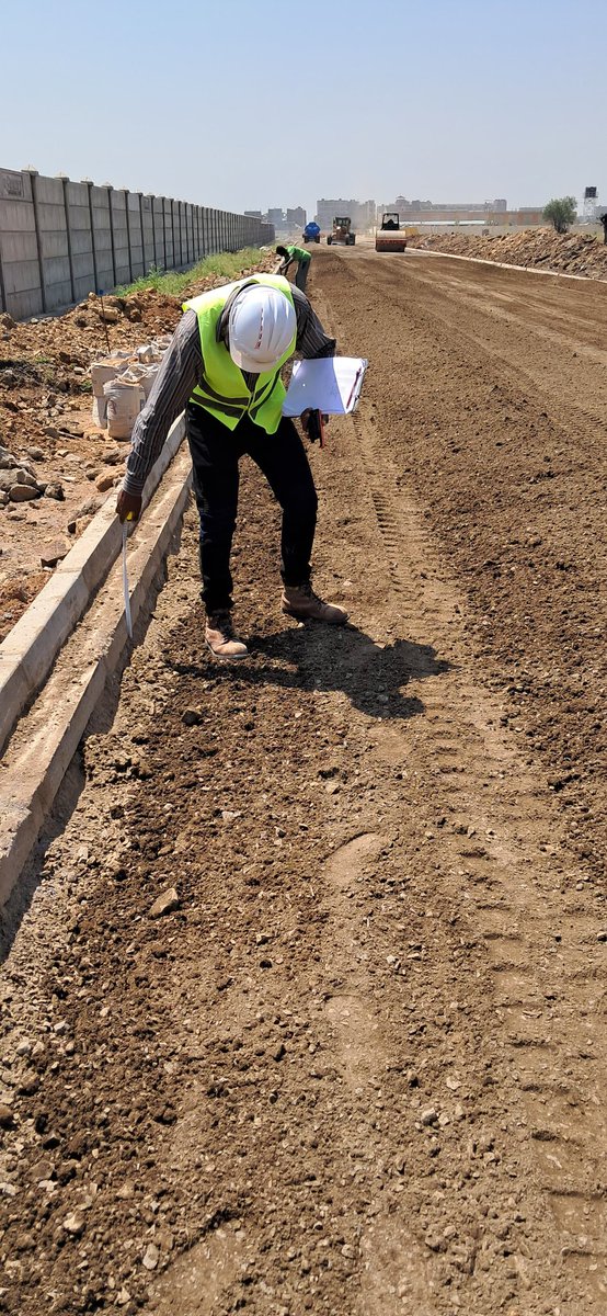
150 mm thick cement treated, Graded crushed stone, stabilized, laid, rolled and compacted to specifications. More watering to cure before laying tarmac. #Highwaygeometry #Engineeringsurvey #Geospatialtechnology


Geospatial opportunities, As you keep it #GIS #GeospatialTechnology #remotesensing , here are a few opportunities. · @UNICEF - Consultation internationale (6 mois) - Etude du suivi de la température lors du transport des vaccins et de la cartographie des chambres froides,…


Exciting news! Esri Rwanda, in collaboration with Rwanda Space Agency, is thrilled to announce our GIS Day 2023 celebration with University students and Lecturers at UR, AUCA, and Ines Ruhengeli! #GISDay2023 #GIS #geospatialtechnology


🌐 The future of geospatial technology is here, and it's built by Foursquare. The power of location data can define how your consumers interact with the world around them. Learn more 👉 location.foursquare.com/?utm_source=tw… #Foursquare #geospatialtechnology


Introducing the Gap Analyser tool, crafted by BISAG-N for @TribalAffairsIn under the Particularly Vulnerable Tribal Groups Scheme. This tool meticulously measures gaps in essential parameters outlined by the ministry. 📊✨ #GeospatialTechnology #DigitalIndia


Convened meeting of officials of National Institute of GeoInformatics Science&Technology #NIGST,only one of its kind in India,along with team of Capacity Building Commission at #Hyderabad.Online courses in #GeospatialTechnology to be made available through iGoT Karmayogi platform


We joined the “From Data to Decisions” workshop on #GeospatialTechnology, AI, and Risk Assessment in Southeast Asia. During the session, we shared lessons from Lao PDR on using Earth Observation for climate #resilience & facilitated a session on UN-ASIGN and decision tools.


Introducing the Gap Analyser tool, crafted by BISAG-N for @TribalAffairsIn under the Particularly Vulnerable Tribal Groups Scheme. This tool meticulously measures gaps in essential parameters outlined by the ministry. 📊✨ #GeospatialTechnology #DigitalIndia


#MGISS, one of the UK’s leading technology firms, supports @FMConwayltd to reduce on-site risks using augmented reality. cpnonline.co.uk/features/mgiss… @mgissuk #geospatialtechnology


Thursday Top with ⭐ APGLOS Survey Wizard ⭐ 🌍 🌎 🌏 🌍 🌎 🌏 🌍 🌎 🌏 🌍 🌎 🌏 GWF GEOSPATIAL WORLD FORUM 2-5 May 2023 Rotterdam, The Netherlands. #geospatial #geospatialtechnology #geography #gnss #education #geodesy #geospatialintelligence #mapping #landsurveying


Geospatial World Forum 2023 Heads to Rotterdam this May buff.ly/3oOtVQQ #geospatial #geospatialtechnology #mapping


Not long to go until @InsideIntergeo 2023! We’ll be showcasing the latest technology for hybrid positioning, structural health monitoring, network correction services and more. Find us at Hall 1.2 Booth C1.053. ow.ly/TLLf50PSsI3 #INTERGEO2023 #geospatialtechnology

Watch all the groundbreaking sessions and keynotes from @Google Public Sector's #GeoforGov event. Dive into the latest innovations in #geospatialtechnology: carah.io/GeoForGovOnDem…
New Applications on Teledyne CARIS Cloud Platform Support S-100 Production buff.ly/40ZgWsR #geospatial #geospatialtechnology #hydrospatial #technology #cloud

Version 24.1 of the Global Mapper SDKs Include New Features & Updates buff.ly/40NDhu4 #geospatial #geospatialtechnology #gis #mapping #software


📍At #INTERGEO2024, WGIC hosted its board and member meeting. #INTERGEO #GeospatialTechnology #GeospatialIndustry #GIS #RemoteSensing #EarthObservation @InsideIntergeo


Today's workshop dove into Meghalaya State Geoportal and Geospatial Dashboards, equipping our PMU Consultants and GIS SPMU staff with advanced mapping tools. Building capacity for better decision-making and project implementation. #GeospatialTechnology #CapacityBuilding #GIS


We are a Platinum Sponsor at the upcoming AGI NI Conference on June 28th. Our team members will present some interesting topics for this year’s theme, “GI and Spatial for the Future – Here and Now.” @GeoCommunity #geospatialdata #geospatialtechnology #teamesriireland


To save you time and cut the chase, GeoWorld returns 24–27 November 2025 at Za’abeel Halls 4–6, Dubai World Trade Centre Opportunities like this don’t wait and neither should you Get your free ticket now: bit.ly/3VUKEiD #GeoWorld #GeospatialTechnology

🚀 Unlock the Future of Geospatial Intelligence! 👉 Dive into the full list here: internationalconferencealerts.com/conference/gis #GISConferences2025 #GeospatialTechnology #MappingInnovation #DataVisualization #UrbanPlanning #DisasterManagement #GIS #Internationalconferencealerts


The 28East team is a passionate group of Google Maps experts dedicated to making your business thrive. 🌟 Get in touch to see how we can help you reach your business goals: 28east.co.za #GoogleMaps #DataProcessing #GeospatialTechnology #LocationBasedServices


🐠 As environmental and climate threats intensify and become more frequent, The Nature Conservancy’s work in the Caribbean offers a compelling blueprint for global conservation. hubs.ly/Q03PNJsm0 #ClimateResilience #GeospatialTechnology #ENVI #GIS @nature_org

We joined the “From Data to Decisions” workshop on #GeospatialTechnology, AI, and Risk Assessment in Southeast Asia. During the session, we shared lessons from Lao PDR on using Earth Observation for climate #resilience & facilitated a session on UN-ASIGN and decision tools.
Discover how automation and geospatial innovation are reshaping the way industries and governments manage land acquisition. Read the full story : sparcindia.com/blog-post/how-… #SPARCIndia #LandAcquisition #GeospatialTechnology #AutomationInAction #DigitalTransformation


Experts will discuss how geospatial tools, satellite data, and predictive models can support smart decision-making, improve urban planning, and promote sustainable land management for Tamil Nadu’s future. #TamilNaduLanduse2025 #GeospatialTechnology #LandUsePlanning #Innovation

Hey! Northern BC founded technology company here (@sparkgeo), heading to climate week! I would love to connect to talk about BC's global influence on #geospatialtechnology. And how #geospatial is one of the few technologies that can provide unbiased data on landscape changes.

Maury's Top Three picks from TopoDOT v2025.2, out now! 🥇 Digital Terrain Model (DTM) Preview Tool 🥈 International Roughness Index (IRI) Analysis Tool 🥉 Control Point to Data Assessment Updates #GeospatialTechnology #ProductDevelopment #DTM #PavementAnalysis

Geospatial opportunities, As you keep it #GIS #GeospatialTechnology #remotesensing , here are a few opportunities. · @UNICEF - Consultation internationale (6 mois) - Etude du suivi de la température lors du transport des vaccins et de la cartographie des chambres froides,…
150 mm thick cement treated, Graded crushed stone, stabilized, laid, rolled and compacted to specifications. More watering to cure before laying tarmac. #Highwaygeometry #Engineeringsurvey #Geospatialtechnology

Geospatial Technology #geospatialtechnology #whyinnews #geospatialpolicy #nationaldevelopment #locationcentricindustry #economy #geospatialdata #mapsservices #geospatialecosystem #geographicmapping #earth #humansocieties #geographicinformationsystem #gis #remotesensing


#MGISS, one of the UK’s leading technology firms, supports @FMConwayltd to reduce on-site risks using augmented reality. cpnonline.co.uk/features/mgiss… @mgissuk #geospatialtechnology
We recently laid out our expectations for spatial technology trends in 2023, and it's incredible to see how quickly the technology is evolving. Learn more about our updated predictions. Read on👇 location.foursquare.com/resources/blog… #geospatialtechnology #locationtechnology

🌐 The future of geospatial technology is here, and it's built by Foursquare. The power of location data can define how your consumers interact with the world around them. Learn more 👉 location.foursquare.com/?utm_source=tw… #Foursquare #geospatialtechnology
Geospatial World Forum 2023 Heads to Rotterdam this May buff.ly/3oOtVQQ #geospatial #geospatialtechnology #mapping
Introducing the Gap Analyser tool, crafted by BISAG-N for @TribalAffairsIn under the Particularly Vulnerable Tribal Groups Scheme. This tool meticulously measures gaps in essential parameters outlined by the ministry. 📊✨ #GeospatialTechnology #DigitalIndia
Exciting news! Esri Rwanda, in collaboration with Rwanda Space Agency, is thrilled to announce our GIS Day 2023 celebration with University students and Lecturers at UR, AUCA, and Ines Ruhengeli! #GISDay2023 #GIS #geospatialtechnology

Introducing the Gap Analyser tool, crafted by BISAG-N for @TribalAffairsIn under the Particularly Vulnerable Tribal Groups Scheme. This tool meticulously measures gaps in essential parameters outlined by the ministry. 📊✨ #GeospatialTechnology #DigitalIndia

New Applications on Teledyne CARIS Cloud Platform Support S-100 Production buff.ly/40ZgWsR #geospatial #geospatialtechnology #hydrospatial #technology #cloud
Convened meeting of officials of National Institute of GeoInformatics Science&Technology #NIGST,only one of its kind in India,along with team of Capacity Building Commission at #Hyderabad.Online courses in #GeospatialTechnology to be made available through iGoT Karmayogi platform

Do you have questions about #geospatialdata or #geospatialtechnology?🌎Email a Tarin GeoWizard today, we'd love to get nerdy and chat about anything #geospatial. Email [email protected] today. #geospatialhub


It's landed! This year's #GeospatialEngineering should be through your letterbox imminently 📬 Digital version coming soon, or grab a copy from us @GEOBusinessShow! 🤝 #geospatial #GeospatialTechnology #GeospatialSurveying #GeospatialData #GeoBusiness #engineering


Version 24.1 of the Global Mapper SDKs Include New Features & Updates buff.ly/40NDhu4 #geospatial #geospatialtechnology #gis #mapping #software

Did you know there's a new Geospatial Technology Competency Model? Read our blog: bit.ly/3R5Yps6 to learn more. #GeospatialTechnology #CompetencyModel #COSBlog #COSResources

Thursday Top with ⭐ APGLOS Survey Wizard ⭐ 🌍 🌎 🌏 🌍 🌎 🌏 🌍 🌎 🌏 🌍 🌎 🌏 GWF GEOSPATIAL WORLD FORUM 2-5 May 2023 Rotterdam, The Netherlands. #geospatial #geospatialtechnology #geography #gnss #education #geodesy #geospatialintelligence #mapping #landsurveying

The National Geospatial Policy, 2022 was notified on December 28, 2022. However, what does the policy mean and what implications does it hold for us? Find your answers here. #cprgindia #geospatialtechnology #geospatial #india #publicpolicy #policy @RamanandDelhi


Something went wrong.
Something went wrong.
United States Trends
- 1. Cheney 129K posts
- 2. Election Day 127K posts
- 3. Jakobi Meyers 3,212 posts
- 4. #csm219 3,216 posts
- 5. Mamdani 575K posts
- 6. Logan Wilson 8,032 posts
- 7. Shota 17.4K posts
- 8. GO VOTE 98.5K posts
- 9. Cuomo 275K posts
- 10. New Jersey 208K posts
- 11. Iraq 57K posts
- 12. Rickey 1,979 posts
- 13. #tuesdayvibe 2,584 posts
- 14. New Yorkers 84.1K posts
- 15. New York City 171K posts
- 16. #TheView N/A
- 17. #Election2025 3,067 posts
- 18. No ID 68.9K posts
- 19. Waddle 6,084 posts
- 20. Halliburton 5,479 posts