#geospatialintelligence ผลการค้นหา

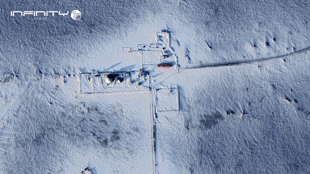
🚀 At Infinity Space, we transform 🌍 satellite data into powerful #GeospatialIntelligence (GEOINT) for defence & security. From terrain mapping 🗺️ to movement detection 👀 👉 Learn more: infinityspace.org.uk/military-geosp… #Satellites #DefenceTech

Industries globally are grappling with the impacts of climate change, legacy infrastructure, and rising operational costs. Join our LIVE Tech Talk discussion where Altavec’s solutions experts talk about how #GeospatialIntelligence helps utilities and government sectors build and…


Ilgi gaidīts jaunums – fona karšu lejupielāde LVM GEO mobilajā lietotnē! Paplašinot lietotnes funkcionalitāti un iespējas, lietotājiem pieejama iespēja lejupielādēt fona (rastra) kartes lietošanai bezsaistes apstākļos. #lvmgeo #geospatialintelligence #GIS #GIT #kartes


It’s launch day for the “Full Stream Ahead” mission. Watch $BKSY’s second Gen-3 #satellite fly to orbit via @RocketLab today at 7:57 p.m. EDT (11:57 a.m. NZT). Live feed: rocketlabcorp.com/missions/next-… #spacebasedintelligence #geospatialintelligence #GEOINT


Geospatial Innovations Podcast - Episode 5 - National Security and Defense #geoint #geospatialintelligence #security #defense #terrorism #operations #satellites #drones #science youtu.be/TCv5F55DMeI?si…

youtube.com
YouTube
Geospatial Innovations Podcast - Episode 5 - National Security and...

We were honored to host Director of National Intelligence @TulsiGabbard as a keynote speaker at the 2025 GEOINT Symposium! 📸 Picture Credit: @NGA_GEOINT #GEOINT2025 #NationalSecurity #GeospatialIntelligence #ArtificialIntelligence #Innovation #PublicService #DNI

Geospatial Innovations Podcast - Episode 4 Geospatial Intelligence and Global Sustainability #geoint #geospatialintelligence #sustainability #technology #GIS #geospatial #intelligence #climatechange #biodiversity #resourcemanagement #agriculture youtu.be/j3dT8Dmthbc?si…

youtube.com
YouTube
Geospatial Innovations Podcast - Episode 4 Geospatial Intelligence...

Another massive fire is visible in satellite imagery south of Tehran. The impact appears evident in morning imagery and continues to show up in evening remote sensing datasets. #Iran #IsraeliranWar #Geospatialintelligence


Next up at #nrf2023 we have Nextbillion talking about ##geospatialintelligence at the @msft4startups showcase #startups

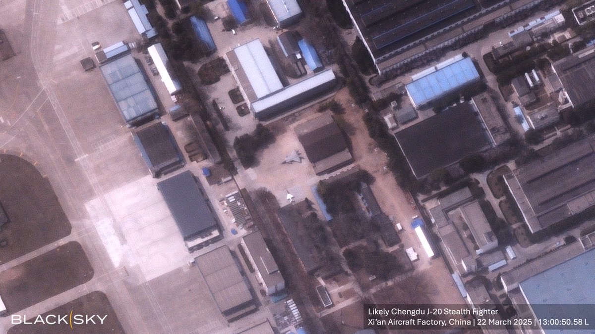
BlackSky's Gen-3 satellite captured what is likely a Chengdu J-20 Stealth Fighter at the Xi’an Aircraft Factory in China this weekend. Check out more images from the factory in the thread. #spacebasedintelligence #gen3 #geospatialintelligence
Geospatial Innovations Podcast - Episode 6 Disastor Response #geoint #geospatialintelligence #disastor #response #technology #GIS #geospatial #intelligence youtu.be/nwg6DcJtlyQ?si…

youtube.com
YouTube
Geospatial Innovations Podcast - Episode 6 - Disaster Response

Check out this informative #video that breaks down what #GeospatialIntelligence (#GEOINT) is and how it's used by various organizations to gain insights for better decision-making. #mapping #technology #innovation #drones #earthobservation #geospatialdata #spatialanalysis

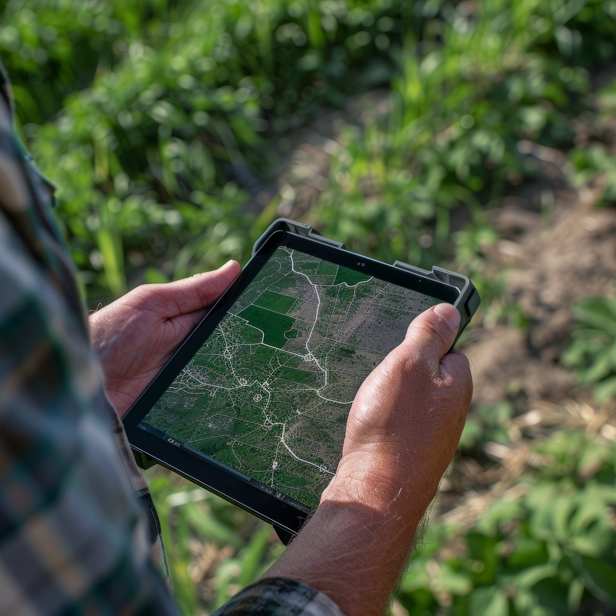
Geospatial intelligence in agriculture can help quickly incorporate aspects of geographic information systems (GIS), remote sensing/satellite imagery, local location data, global positioning systems (GPS), field & equipment sensors, & more! #AgTech #GeospatialIntelligence #GIS


Come and visit GEOSAT's booth at DGI conference in London. We will be happy to welcome you and discuss our capabilities within the #DefenceandSecurity sector. For more information or book a meeting, contact us at [email protected]. See you there! #DGI2024 #GeospatialIntelligence

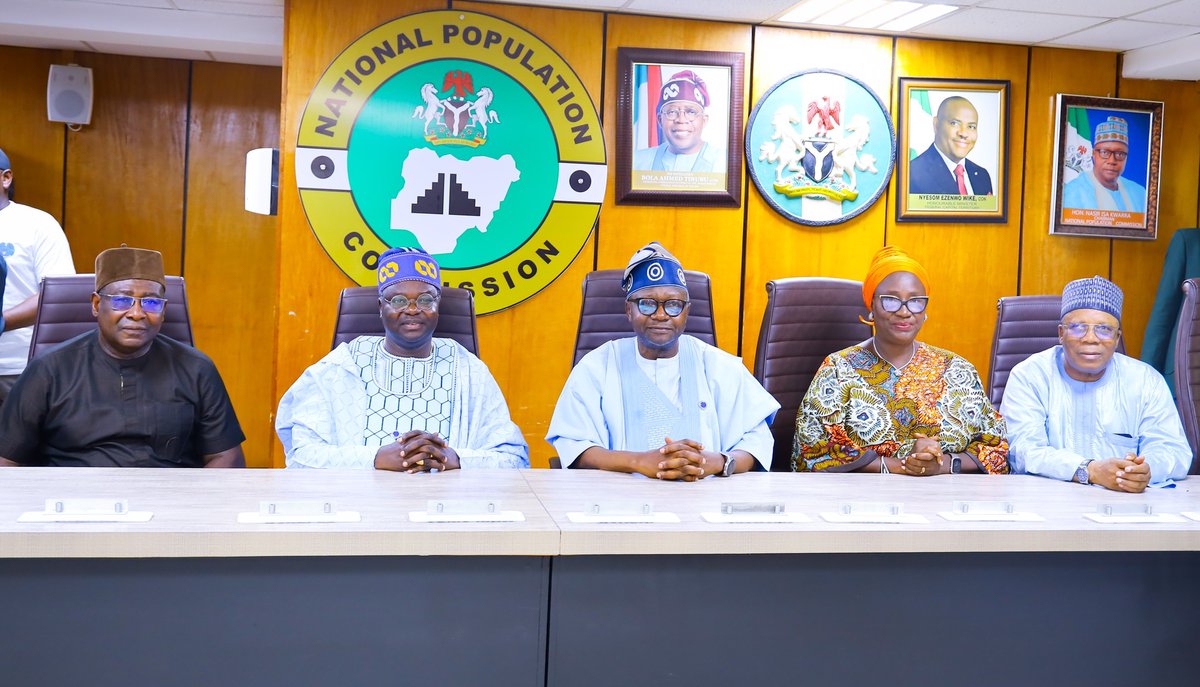
Accurate data builds nations. @NASRDA_Official stands ready to support @natpopcom with satellite data, geospatial intelligence & trained personnel for Nigeria’s most accurate census yet — targeting 98% precision. #NigeriaCensus #GeospatialIntelligence


NPC AND NASRDA FORGE PARTNERSHIP FOR UPCOMING CENSUS Today, the NPC Chairman, Hon. Nasir Isa Kwarra, received in audience the Director-General of National Space Research and Development Agency (NASRDA), Dr. Matthew Olumide Adepoju, and his management team at the NPC HQ in Abuja.


🔍🌏 Discover why Synthetic Aperture Radar (SAR) data is crucial for surveillance in the Asia-Pacific region! 🌧️🛰️ #GeospatialIntelligence #SAR #Taiwan #GlobalSecurity #Semiconductors #GeoOwl @NGA_GEOINT @umbraspace
Unlock the future with high-quality geospatial intelligence from Penn State Extension's Broadband Navigator! Funded by @RockefellerFdn, it helps quickly map underserved areas for local deployment projects. Learn more at #APD #BroadbandEquity #GeospatialIntelligence #Tech4All

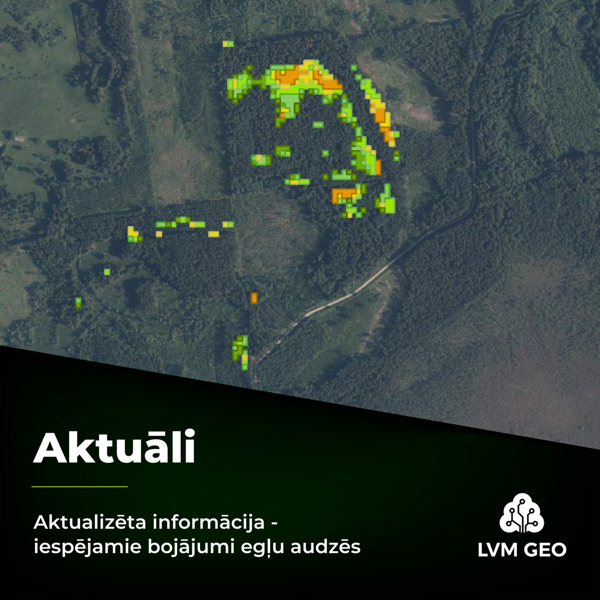
Esam pilnveidojuši mūsu izstrādāto algoritmu audžu vitalitātes izmaiņu apzināšanai egļu mežaudzēs (gan LVM, gan privātajās audzēs) un atjaunojuši datus visos LVM GEO risinājumos. #lvmgeo #geospatialintelligence #GIS #GIT #kartes #remotesensing
Geospatial intelligence may be able to help farmers make data-driven decisions by quickly analyzing large amounts of spatial or location data (i.e., yield data, soil types, growth patterns, etc). #GeospatialIntelligence #SmartFarming #agtech #aiimage

#SpaceTech #GeospatialIntelligence #AIforGood #SmartGovernance #AgriTech #WaterManagement #DigitalIndia #ViksitBharat2047 @INSPACeIND @isro @CMofKarnataka

Exploring the future of #GeospatialIntelligence at #INTERGEO2025 in Frankfurt!Great to connect with global leaders like @Esri & @WGIC, and explore innovations in #GeoAI, #SpatialComputing, and #Sustainability shaping the digital future.

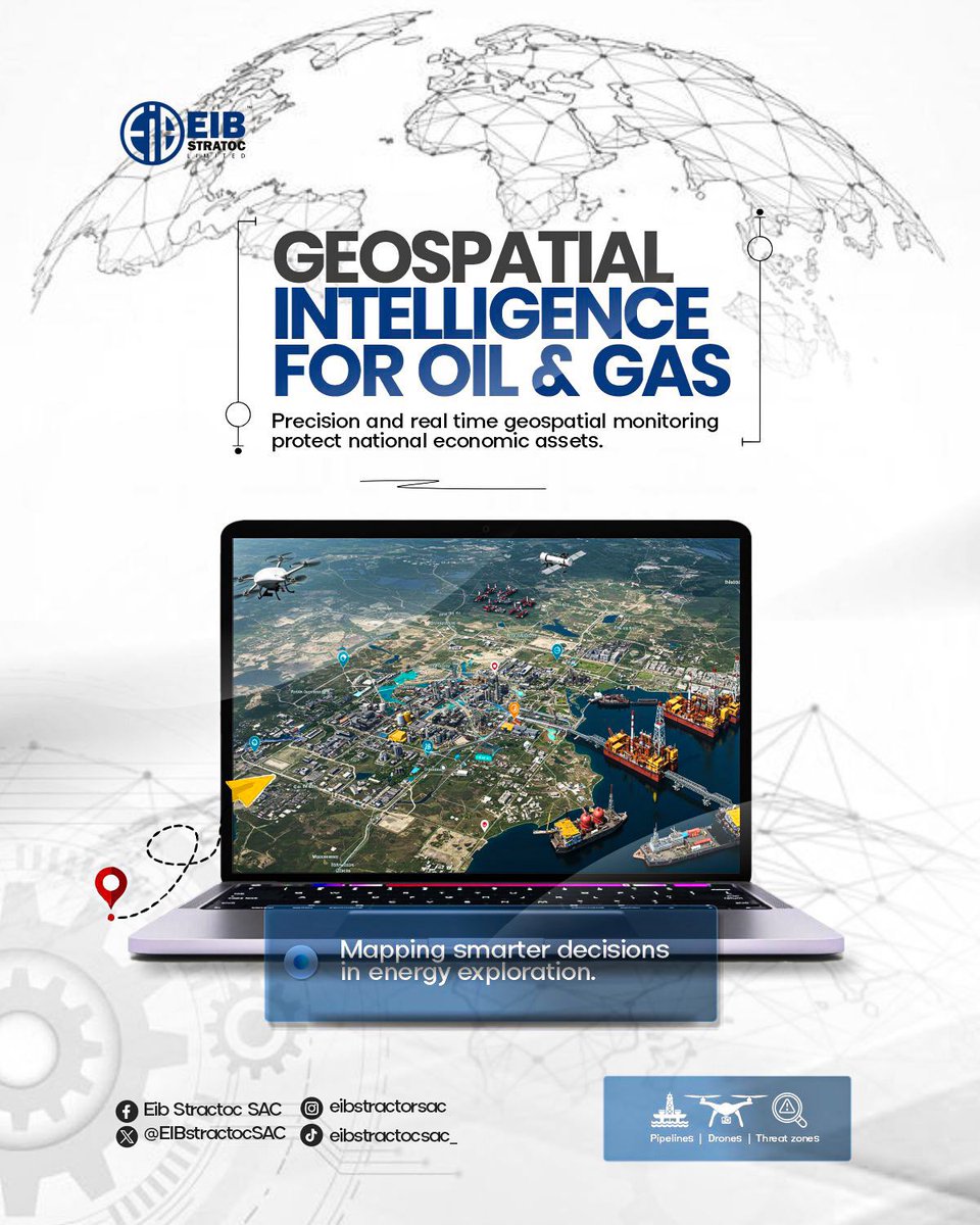
Unlock the power of precision with EIB Stratoc’s Geospatial Intelligence Solutions designed to transform operations in the Oil & Gas sector. #EIBStratoc #GeospatialIntelligence #OilAndGasSolutions #GISMapping #SatelliteSurveillance #EnergyTechnology #IntelligenceFusion

🌐 Unlocking Potential! The NGA is revolutionizing geospatial intelligence by harnessing the power of idle PCs through innovative distributed computing. This new approach aims to enhance analytics and responsiveness in critical operations. #GeospatialIntelligence #Innovation…


🌍✨ We’re Launching Something Big! ✨🌍 Introducing our next-generation WebGIS Platform – designed to transform how we see, analyze, and interact with the world. We will soon be launching our Mapzest Express platform. Stay tuned ✨ #TerrAquaUAV #GeospatialIntelligence

This is not just the end of a chapter but the start of new horizons in research, innovation, and applying geospatial intelligence to solve real-world problems. #GeospatialIntelligence @CustomsNG @nigimmigration

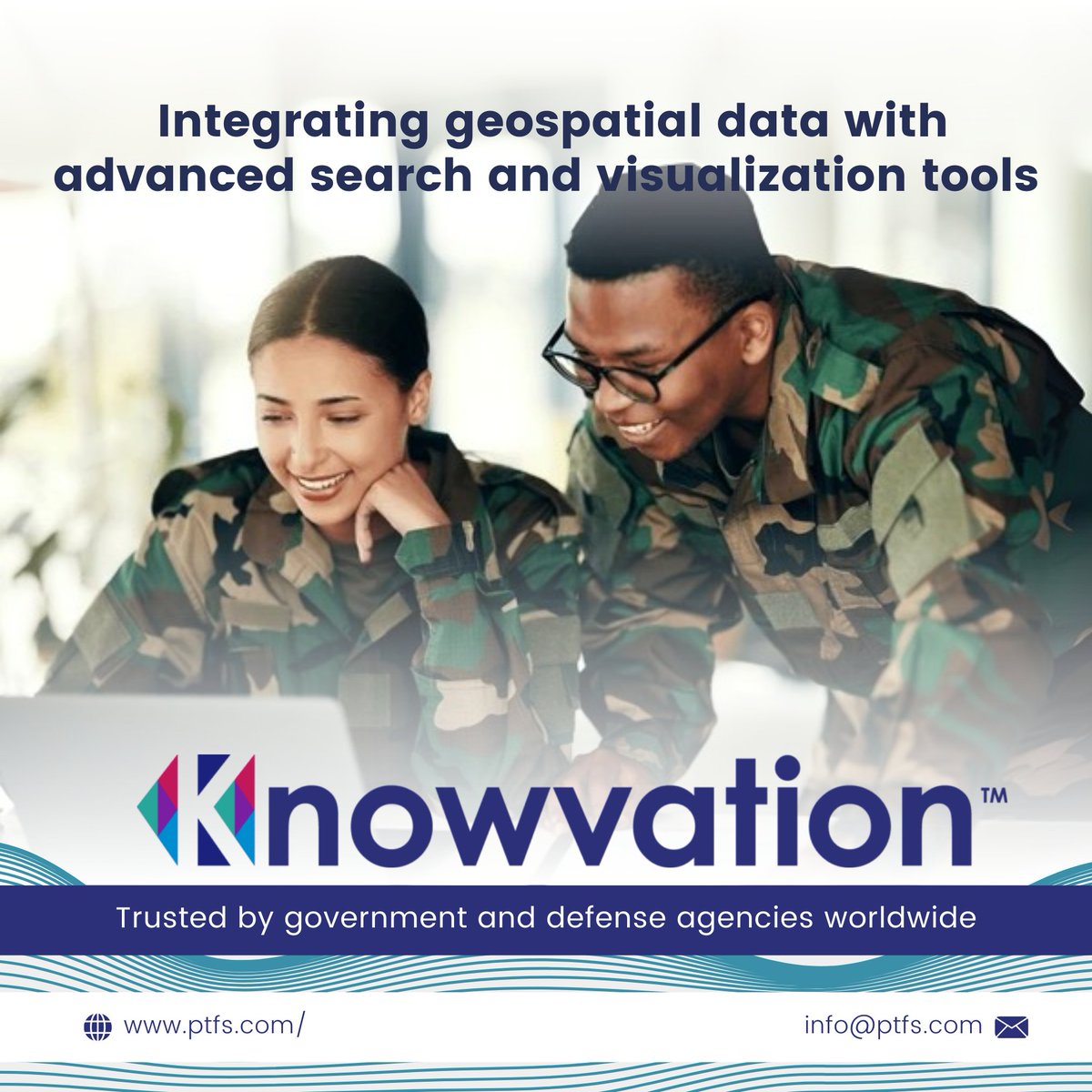
National security. Emergency response. Infrastructure planning. Knowvation GS supports critical missions by integrating geospatial data with advanced search and visualization tools. 👉 Learn more: ptfs.com/knowvation-gs #GeospatialIntelligence #KnowvationGS #PTFS
🚀 At Infinity Space, we transform 🌍 satellite data into powerful #GeospatialIntelligence (GEOINT) for defence & security. From terrain mapping 🗺️ to movement detection 👀 👉 Learn more: infinityspace.org.uk/military-geosp… #Satellites #DefenceTech

Discover how NSG is redefining the future of #geospatialintelligence, #aviationconnectivity, and orbital infrastructure. 🔗Explore the full story: spacenews.com/building-saudi…

As #wildfires become more common in the UK, #geospatialintelligence data needs to be adopted across the #insurance industry to support #pricing, sharper #underwriting, and resilience in the face of a growing environmental threat @InsEdgeOnline bit.ly/4mRqemr
insurance-edge.net
The Rising Wildfire Threat in the UK
Explore the increasing uk wildfire risks as climate change drives more frequent wildfires across the United Kingdom.

So excited to share I am a @AAAS_STPF Congressional Fellow in AI. I’m grateful for the chance to sharpen my teeth on the Hill, bringing technical expertise in #AI, #disasterresilience, and #geospatialintelligence into policy making.


Smarter insights start with better visuals. Discover how #AzureMaps + #Dynamics365 transform CRM data into geospatial intelligence 🎥 youtube.com/shorts/HFXhgMC… #GeospatialIntelligence #CRMdata #integratedmaps

🚀 At Infinity Space, we transform 🌍 satellite data into powerful #GeospatialIntelligence (GEOINT) for defence & security. From terrain mapping 🗺️ to movement detection 👀 👉 Learn more: infinityspace.org.uk/military-geosp… #Satellites #DefenceTech
Ilgi gaidīts jaunums – fona karšu lejupielāde LVM GEO mobilajā lietotnē! Paplašinot lietotnes funkcionalitāti un iespējas, lietotājiem pieejama iespēja lejupielādēt fona (rastra) kartes lietošanai bezsaistes apstākļos. #lvmgeo #geospatialintelligence #GIS #GIT #kartes

India’s Space Regulator Picks Google-Backed Pixxel for Satellites Read More: lnkd.in/dai5iM3x #IndianNationalSpace #geospatialintelligence #EarthObservation #spacetechnology #satelliteconstellation

It’s launch day for the “Full Stream Ahead” mission. Watch $BKSY’s second Gen-3 #satellite fly to orbit via @RocketLab today at 7:57 p.m. EDT (11:57 a.m. NZT). Live feed: rocketlabcorp.com/missions/next-… #spacebasedintelligence #geospatialintelligence #GEOINT
Industries globally are grappling with the impacts of climate change, legacy infrastructure, and rising operational costs. Join our LIVE Tech Talk discussion where Altavec’s solutions experts talk about how #GeospatialIntelligence helps utilities and government sectors build and…
We were honored to host Director of National Intelligence @TulsiGabbard as a keynote speaker at the 2025 GEOINT Symposium! 📸 Picture Credit: @NGA_GEOINT #GEOINT2025 #NationalSecurity #GeospatialIntelligence #ArtificialIntelligence #Innovation #PublicService #DNI

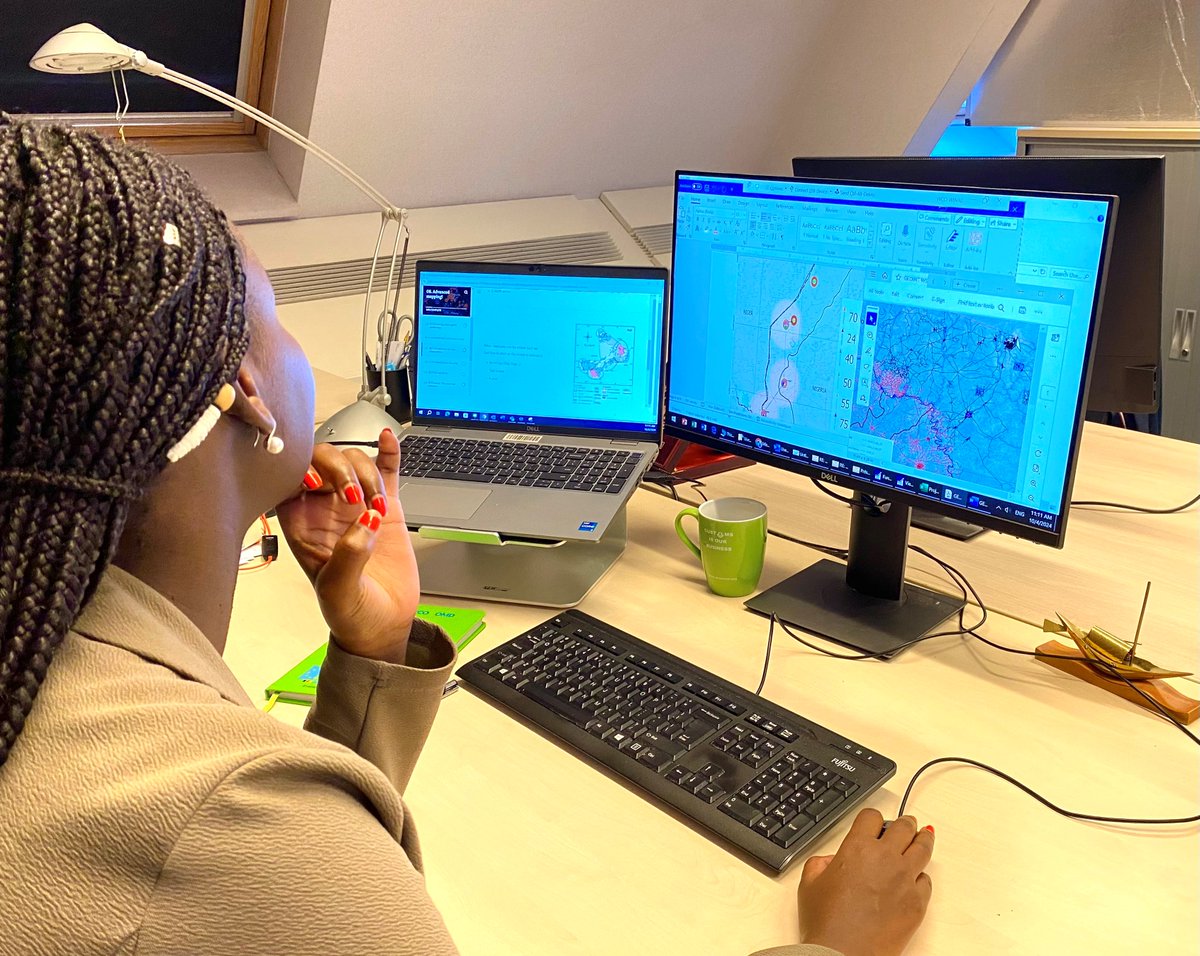
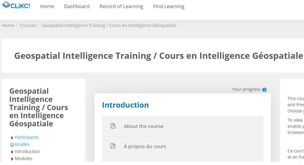
GEOINT e-learning launched on CLiKC! 🔗 wcoomd.org/en/media/newsr… #WCO #Customs #GeospatialIntelligence #GEOINT #eLearning #CLiKC #FragileBorders #WCOSecurityProgramme

BlackSky's Gen-3 satellite captured what is likely a Chengdu J-20 Stealth Fighter at the Xi’an Aircraft Factory in China this weekend. Check out more images from the factory in the thread. #spacebasedintelligence #gen3 #geospatialintelligence
Another massive fire is visible in satellite imagery south of Tehran. The impact appears evident in morning imagery and continues to show up in evening remote sensing datasets. #Iran #IsraeliranWar #Geospatialintelligence

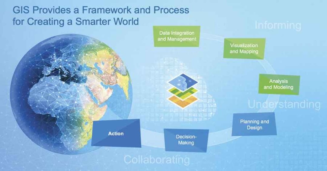
Get ready for a smarter future with #ArcGIS! 🌐📈 This advanced mapping technology helps you make informed decisions and solve complex problems. Join the smart revolution and discover the power of ArcGIS today! 👉hubs.li/Q01S7vT10 #smarterfuture #geospatialintelligence

Connect with our team at the GEOINT Symposium as we explore the evolving landscape of #GeospatialIntelligence alongside industry leaders🛰️ #SidusSpace #GEOINT2024 #GEOINT #EdgeAI #FeatherEdge #Data #Technology #NewSpace


The Innovation’s Virtual Collection—Earth Science V2.0: Geospatial Intelligence is now online! Explore cutting-edge, high-quality studies at @Innov_Geosci the-innovation.org/geoscience/spe… #Geoscience #EarthScience #GeospatialIntelligence #ArtificialIntelligence

🌐 We've talked a lot about real-time intelligence requiring a software-first mindset, but what does this mean in context? How is #AI fundamentally transforming the #geospatialintelligence industry? Get the primer on the shift to space-based #intelligence and why it's crucial…

Esam pilnveidojuši mūsu izstrādāto algoritmu audžu vitalitātes izmaiņu apzināšanai egļu mežaudzēs (gan LVM, gan privātajās audzēs) un atjaunojuši datus visos LVM GEO risinājumos. #lvmgeo #geospatialintelligence #GIS #GIT #kartes #remotesensing
The BlackSky team will be attending this year’s #DGI2024 conference, celebrating 20 years of bringing together the international defence and #geospatialintelligence community. 📅 March 11-13 🤝 Booth 29, 30 📍 London, UK

Strengthening fragile border controls with GEOINT 🔗 wcoomd.org/en/media/newsr… #WCO #Customs #GeospatialIntelligence #GEOINT #BorderSecurity #FragileBorders #WASP #WCO_JICAProject 🇧🇯 🇨🇮 🇬🇭 🇳🇬 🇹🇬

LVM GEO risinājumi ir papildināti ar Valsts zemes dienesta uzturētās Kadastra informācijas sistēmas teksta datiem. Kadastra teksta dati skatāmi mobilajā lietotnē LVM GEO un karšu pārlūkā lvmgeo.lv/kartes. #lvmgeo #geospatialintelligence #GIS #GIT #kartes

Get ready for a smarter future with #GIS! 🌐📈 With advanced mapping technology, GIS helps you make informed decisions and solve complex problems. Join the smart revolution and discover the power of GIS today! 👉hubs.li/Q01GfcRK0 #smarterfuture #geospatialintelligence

Next up at #nrf2023 we have Nextbillion talking about ##geospatialintelligence at the @msft4startups showcase #startups

Join @alteryx and @SnowflakeDB on March 28th, 3pm GMT (11am ET) in an exclusive webinar, 'Supply Chain Intelligence: A Geospatial Approach to Optimal Decision-Making'. Discover more and register now ➡️ bit.ly/491QqmN #GeospatialIntelligence #CustomerCentricity

Something went wrong.
Something went wrong.
United States Trends
- 1. Branch 36.5K posts
- 2. Chiefs 111K posts
- 3. Red Cross 49K posts
- 4. Mahomes 34.5K posts
- 5. Exceeded 5,958 posts
- 6. Binance DEX 5,153 posts
- 7. #LaGranjaVIP 81.4K posts
- 8. #njkopw 4,643 posts
- 9. Rod Wave 1,593 posts
- 10. Air Force One 54.7K posts
- 11. #TNABoundForGlory 58.8K posts
- 12. #LoveCabin 1,354 posts
- 13. Tel Aviv 57.7K posts
- 14. Bryce Miller 4,583 posts
- 15. Alon Ohel 14.5K posts
- 16. Eitan Mor 14.5K posts
- 17. LaPorta 11.9K posts
- 18. Omri Miran 14.8K posts
- 19. Matan Angrest 13.8K posts
- 20. Goff 13.9K posts