#jsspatial search results

Cartographier pour le web avec la bibliothèque JavaScript bertin. #Sageo2023 #JSspatial Slides 👉 neocarto.github.io/bertin-sageo20…

🌐 In #bertinjs, you can now map your data on interactive globes 🌐 #JSspatial observablehq.com/@neocartocnrs/…
Hello geogrid 🎉 #JavaScript #JSspatial 👉 code: github.com/neocarto/geogr… 👉 live demo: observablehq.com/@neocartocnrs/…

TUTO - cartographie thématique avec {ojs} neocarto.github.io/geounivr2024/V… @observablehq @quarto_pub #JSspatial #geoviz

Réaliser une single page application avec @quarto_pub et bertin. #JSspatial #DIY 👉 tuto : ee-cist.github.io/CAR2_cartodyn/… 👉 résultat final : ee-cist.github.io/CAR2_cartodyn/…
Hello Geoviz 🪄 #JSspatial @observablehq 👉 observablehq.com/@neocartocnrs/… 👉 github.com/neocarto/geoviz
Thanks to the update function, the bertin library allows you to modify smoothly some features of the map without redrawing everything. #JSspatial #Maps observablehq.com/@neocartocnrs/…
Let's draw interactive thematic globes with #bertinjs & @observablehq. #JSspatial 👉 observablehq.com/@neocartocnrs/…
In the bertin library, it is now possible to show and hide layers with transitions. #JSspatial #Maps observablehq.com/@neocartocnrs/…
Tuto - Savoir faire des cartes interactives avec @quarto_pub et la bibliothèque #JavaScript bertin. #JSspatial #Cartography #DIY 👉 ee-cist.github.io/CAR2_cartodyn/…
The domination of #GAFAM on the worldwide web (feat @lecartographe) #JSspatial observablehq.com/@neocartocnrs/…
Did you know that you can do this kind of stuff with bertin? #JSspatial @observablehq #Maps #DataViz observablehq.com/@neocartocnrs/…


Last update. The bertin dots layer is now available in [email protected]. #JavaScript #GeoViz #JSspatial 👉 observablehq.com/@neocartocnrs/…


Let's densify a geoJSON in javascript with #geotoolbox & @observablehq 👉 observablehq.com/@neocartocnrs/… #JSspatial #GIS #GeoWeb
From [email protected], it is possible to rewind the geojson display in each layer by using rewind = true #JSspatial #bertinjs #geojson
A function to import any any basemap in any format (shp, gpkg, gml, kml, csv...) in @observablehq 👉 observablehq.com/@neocartocnrs/… #GIS #geomatics #JSspatial #gdal


An @observablehq notebook about the proj4js library observablehq.com/@neocartocnrs/… #JSspatial #GeoJS

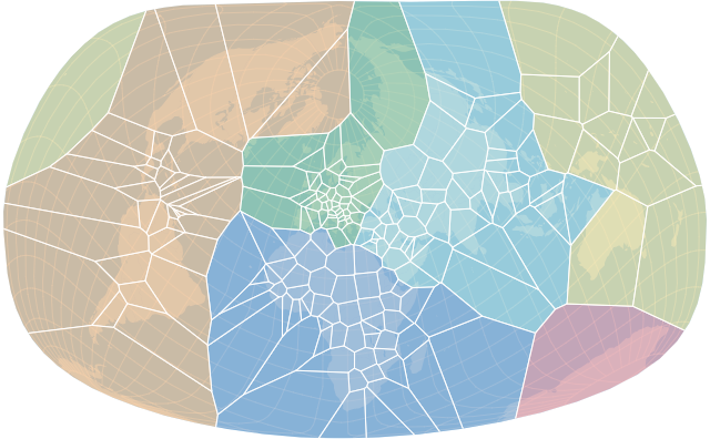
Top story: @neocartocnrs: 'It was missing. In #bertin, you can now make choropleth maps with a geometric progression. #JSspatial #cartography observablehq.com/@neocartocnrs/… ' https://t.co/hXRnBnQBg6, see more tweetedtimes.com/v/1527?s=tnp
observablehq.com
Bertin.js: choropleth
The term "choropleth" was invented in 1938 by the American geographer John K. Wright. It is derived from the word plethos meaning quantity ans the word khôra meaning space (country, territory). In...

Africa: a Murdered Continent. Interactive maps designed with #bertinjs & @observablehq based on the Uppsala Conflict Data Program. #JSspatial #NoWar #StopWar observablehq.com/@neocartocnrs/…


Since today, @observablehq Plot allows to use geographical marks 🥳. This is what I tested quickly this morning. Conclusion: it's quite easy to use. Congrats to @recifs & @mbostock for this great work 👍 observablehq.com/@neocartocnrs/… #JSspatial


Good news! It is now possible to design maps with @observablehq Plot. #JSspatial observablehq.com/@observablehq/…
observablehq.com
Mapping / Observable Plot
To make a map, follow the order of things described by the painter Wassily Kandinsky in Point and Line to Plane (1926): lay out your planes (areas, filled polygons), draw lines above them (contours,...
N'oubliez pas le webinaire de mercredi (12h30) où nous avons la chance d'accueillir @recifs qui nous parlera de ses visualisations cartographiques avec @observablehq. Venez écouter, ca vaut le coup ! Lien de connexion ci-dessous ⤵️ @GdrMagis #JSspatial github.com/magisAR9/webin…

This #bertin cheat sheet was made with the javascript library #bertin. Therefore, it is not cheating at all 🤔🤷♂️ #JSspatial @observablehq observablehq.com/@neocartocnrs/…

À vos agendas 📅 @recifs @observablehq #30DayMapChallenge #JSspatial @GdrMagis #7dec2022 github.com/magisAR9/webin…


[REPLAY] presentation of @observablehq for the @InseeFr data-scientists network (in french 🇫🇷). Thanks to @LinoGaliana for the invitation. #DataViz #JsSpatial #Observablehq ssphub.netlify.app/talk/presentat…
![neocartocnrs's tweet image. [REPLAY] presentation of @observablehq for the @InseeFr data-scientists network (in french 🇫🇷). Thanks to @LinoGaliana for the invitation. #DataViz #JsSpatial #Observablehq ssphub.netlify.app/talk/presentat…](https://pbs.twimg.com/media/FiO5PZCX0AUVhhF.jpg)


I am currently testing @observablehq teams to teach #cartography at @univ_paris_cite. If you want to discuss this or have any feedback or questions, please contact me. Everything is private for now, but all resources (in french) will become public gradually. #JSspatial
#30DayMapChallenge Day 4: Color Friday: Green observablehq.com/@neocartocnrs/… #JSspatial #FlowePower 🌻
Several Ways to Represent Dead and Missing Migrants in the Mediterranean with #bertinjs. Does it remind you of anything @rgeomatic? #JSspatial observablehq.com/@neocartocnrs/…
Computing Stewart's Potentials with gpu.js (by Matthieu Viry) #JSspatial observablehq.com/@mthh/stewarts…
In [email protected], it is now possible to compute regular grids from administrative delineations. #MAUP #JSspatial #bertinjs observablehq.com/@neocartocnrs/…
Something went wrong.
Something went wrong.
United States Trends
- 1. Giants 64.6K posts
- 2. Bills 133K posts
- 3. Seahawks 17.3K posts
- 4. Bears 57.3K posts
- 5. Caleb 46.9K posts
- 6. Dart 25.1K posts
- 7. Dolphins 31.6K posts
- 8. Daboll 10.8K posts
- 9. Jags 6,457 posts
- 10. Josh Allen 15.1K posts
- 11. Russell Wilson 3,827 posts
- 12. Texans 36.7K posts
- 13. Browns 36.4K posts
- 14. Patriots 102K posts
- 15. Ravens 36.5K posts
- 16. Rams 14.6K posts
- 17. Henderson 16.5K posts
- 18. Trevor Lawrence 2,399 posts
- 19. Bryce 15.2K posts
- 20. Drake Maye 15.1K posts