#lidarmapping نتائج البحث
Our team with AFAD will use airborne LiDAR to map ruptured faults in SE Turkey after the earthquake. The data will aid in relief efforts and future risk evaluation. #EarthquakeRecovery #LiDARMapping #SETurkey


Visual inspection is a common method of quality control, data acquisition, and data analysis. Send us an e-mail: [email protected] #UMInspections #LIDARMapping


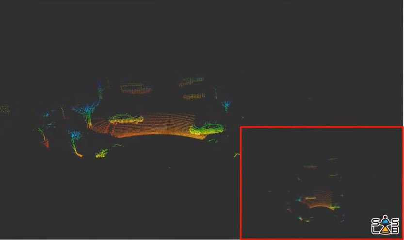
🔥Look, there's a strange guy here. 😮A handheld LiDAR Scanner for mapping. ● Support EAI X3 Pro, EAI T-mini plus, SLAM C1, Oradar MS200, EAI 4ROS Lidar ● Using MicroROS wireless communication technology ● With 7.4V 2000mah battery pack #Lidar #Mapping #Lidarmapping #ROS

Tim Webster at the @GeoIgnite conference where he'll be sharing his expertise on #lidarmapping to solve coastal problems and support sustainable development #NSCCresearcherinOttawa
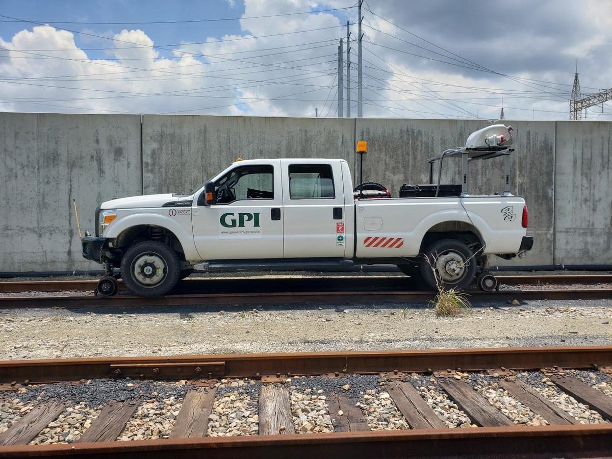
Did you know that GPI Geospatial provides high accuracy railroad mapping? Check out our Riegl VMX-450 mounted on a customized truck for rail corridor mapping. #gpigeospatial #lidarmapping #railroadmapping

After a demo with the @flyability #Elios3 at @theohiostateuniversity, we helped at a campus fundraiser with a demonstration that showed the Elios 3 commands and a live stream to attendees of the #LiDARMapping capabilities while flying inside.


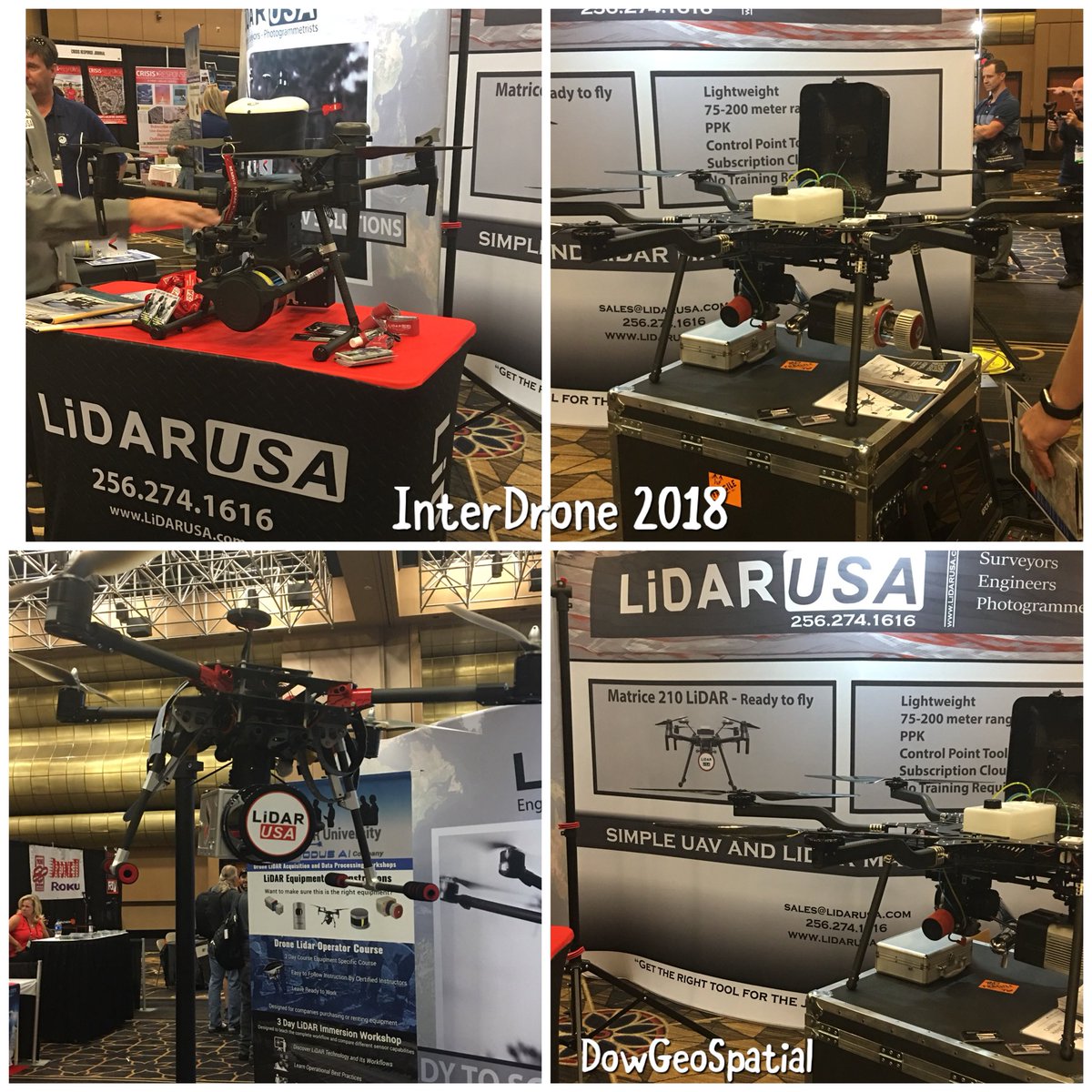
Come to see our latest #utilitymapping #99%accurate #LiDARCloud & #LiDARmapping solutions at the #InternationalLiDARMappingForum @ILMF17


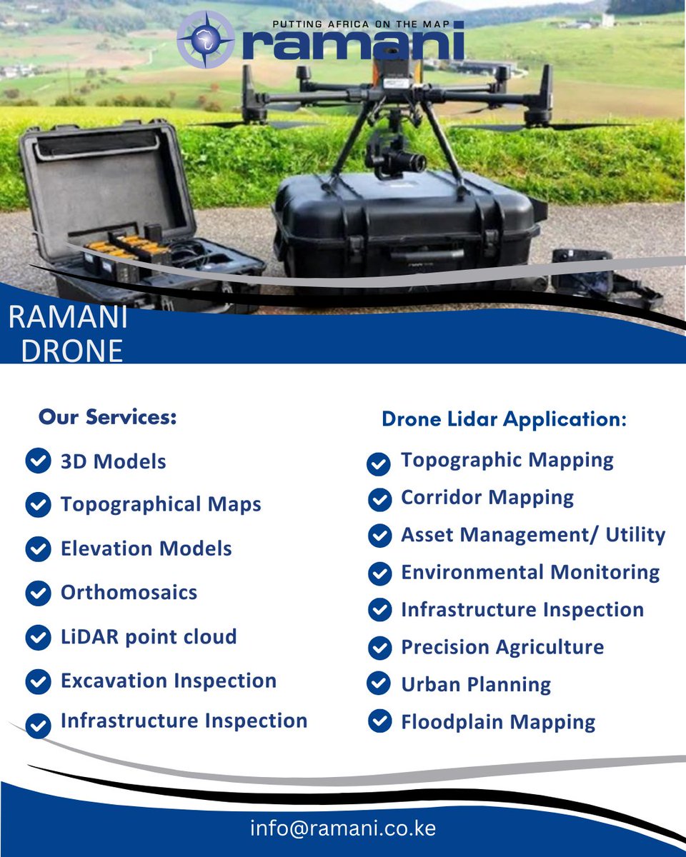
Contact Us: [email protected] or WhatsApp 0722200616 #DroneSurvey #AerialSurvey #LiDARMapping #GeospatialTech #RemoteSensing #GIS #UAVMapping #Surveying #3DMapping #TopographicSurvey #MappingAfrica #RamaniGeosystems
Reach out to us by sending a message or filling out a contact form at our website: uminspections.com #UMInspections #LIDARMapping


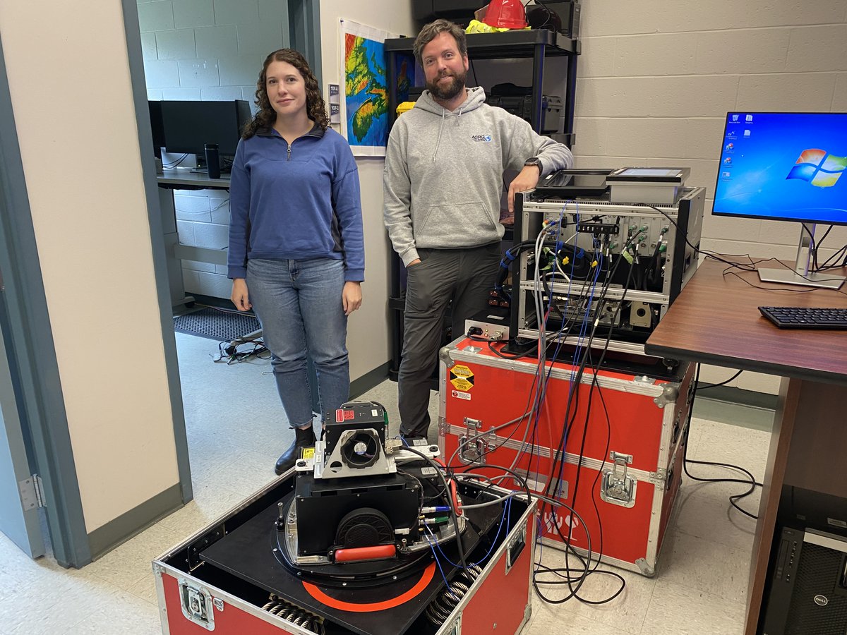
Our geomatics research lidar team is gearing up to take flight over Sable Island. They'll be capturing topo lidar data and orthophotos to explore and map this unique landscape. Stay tuned for more updates from the skies! #AGRG #LidarMapping #SableIsland #ResearchInAction
Charis Côte d’Ivoire is conducting detailed LiDAR mapping for San-Pédro, one of largest cities in Côte d’Ivoire. Why it matters: ✔ Identifying flood-prone areas ✔ Delivering innovative hydraulic solutions ✔ Supporting sustainable urban development #LiDARMapping #SmartCities


Integrating open satellite w/hi-res LiDAR data advances the UN’s Sustainable Development Goals. NASA’s Brian Killough & VoxelMaps’ Peter Atalla will discuss use of satellite cubes at www.EarthArchiveCongress. Free attendee registration! #EarthArchiveCongress #LIDAR #LidarMapping


🚀🌍 Successful test of orbital Lidar! We're now able to create high-resolution 3D maps of planet Earth with incredible precision. A major step forward in space innovation and planetary exploration! 🌟 #LidarMapping #SpaceTech #Innovation


Visit @dielmo3d at the ILMF17 (International LiDAR Mapping Forum) in Denver (CO) #utilitymapping #99%accurate #LiDARCloud #LiDARmapping


$CYBL @MDSAdvisor “NURK” on the Tech Advisory Board & Chief Test Pilot is a Revenue Game Changer for the @CyberluxC Drone UAV Program, especially with 5G & AI Flight Technology: #DOD #LidarMapping #MilitaryGradeSystems #EyeInTheSky #GeoFencing #InfraredNightVision #ThermalSensor

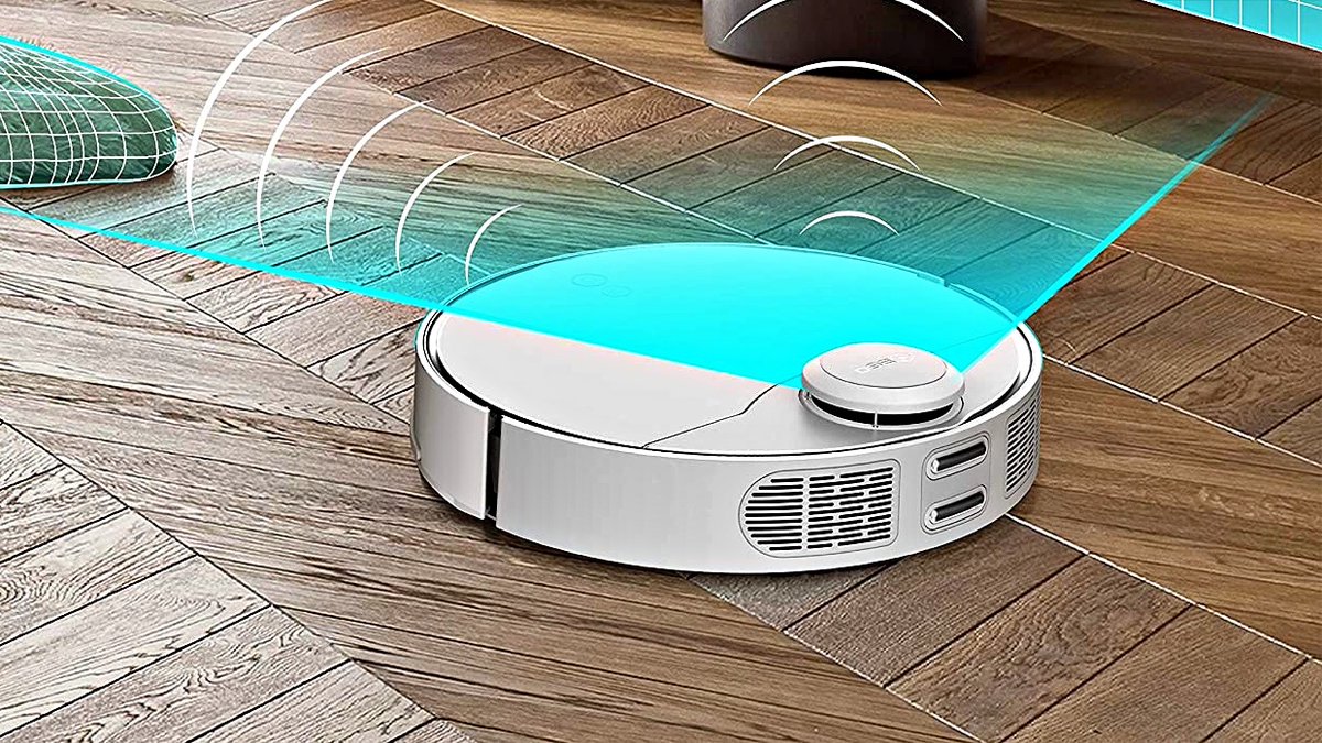
NEW VIDEO: Most Powerful Robot Vacuum Cleaner - 360 S9 | LIDAR Navigation Mapping | Alexa Control - Any good? ▶️ youtu.be/8T-4eKNKJ5o --- #360S9 #LIDARmapping #360SmartLife #Alexa #GoogleHome


Unlock precision with LiDAR Data Processing at 3D PointShot ! Get accurate terrain models, 3D visualizations & detailed insights for your projects. Contact Us: 🌐: 3dpointshot.com/lidar-data-pro… 📞: +91 997833007 #3DMapping #LiDAR #LiDARMapping #GeospatialSolutions


🌍 Welcome to our LiDAR world — where sky meets ground Step into Geosun’s world of LiDAR — connecting the sky above and the ground below with precision 3D mapping. #SkyToGround #LiDARMapping #3DPointCloud #SurveyingInnovation #GeosunLiDAR #Geosun
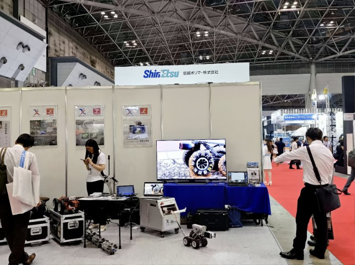
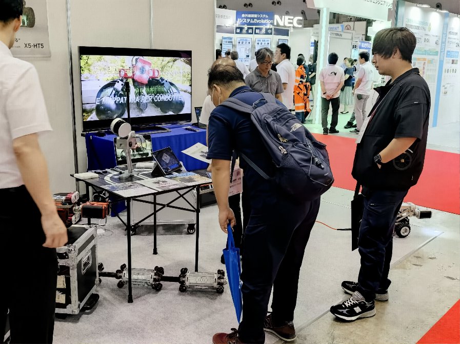
🇯🇵 When customers become your best ambassadors. Maintenance & Resilience Tokyo 2025 Our GEOSUN GS-120G made its appearance—not by us, but by our customer. 💼✨ #MaintenanceAndResilience2025 #CustomerTrust #LiDARMapping #SLAMLiDAR #GeosunLiDAR #Surveying #3DScanning #GEOSUN


![LovingMY_Aniya's profile picture. Mother Of Two Gorgeous Girls [Aniya & Aaliyah] Wifey Of An Amazing Rapper [Travis] ♥12.30.11| 09.06.2013 | 06.06.12♥](https://pbs.twimg.com/profile_images/2886117351/b917e09a047da64df072e808bdbbd2f8.jpeg)
University researchers use drone LiDAR to map mangrove canopy structure, quantifying biomass and carbon sequestration potential. #LiDARMapping #BlueCarbon

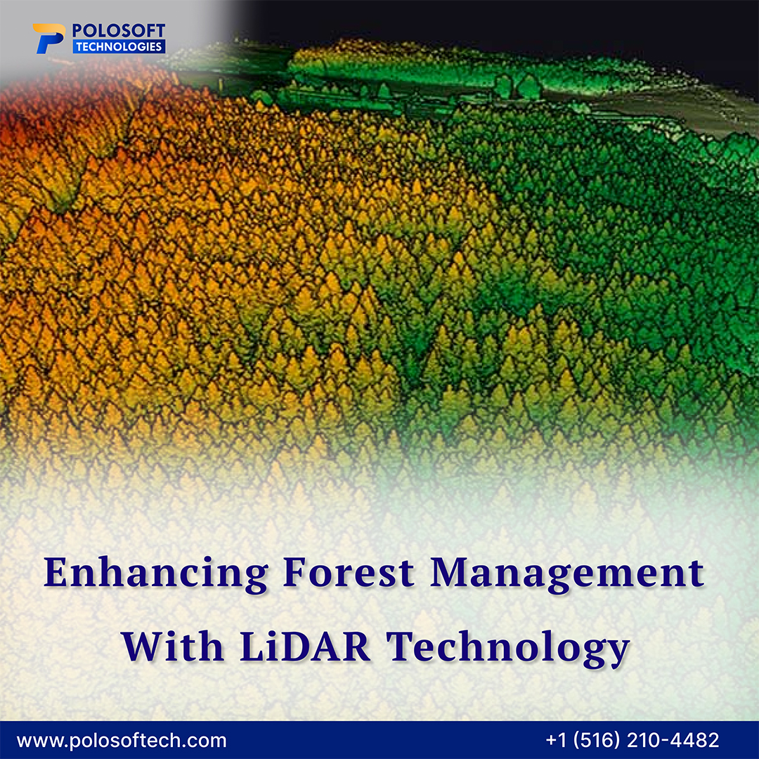
#PolosoftTechnologies’ LiDAR solutions accurately analyze tree vegetation, canopy structure, and forest health for smarter, sustainable decisions. polosoftech.com/geospatial-ind… #LiDARMapping #ForestManagement #TreeVegetation #LiDAR #TreeMapping #PrecisionForestry @LandSurveyorsU
The future of measurement is here. And it walks through your site with a LiDAR scanner. SLAM Scan gives you digital twins, instant measurements & high-res walk-throughs. Not just flash—it's functional. #Innovation #DigitalTools #LiDARMapping #NZConstruction
We don’t just scan—we simplify. Get instant 3D models, measurements, and digital layouts of your site. No waiting. No drama. Just results. #SlamScan #LiDARMapping #TimeSaver #SmartTech
LiDAR isn't the future. It's the NOW. We're helping builders, property managers & engineers scan full sites in minutes—not hours. Precise, portable, powerful. Let’s modernize your workflow. #3DScanning #LiDARMapping #SLAMScan #NZTech

Unlock the future of precision mapping with LiDAR remote sensing! Explore how drones equipped with LiDAR are transforming terrain analysis, infrastructure planning, and more. 👉 Read Full Blog: mavdrones.com/lidar-remote-s… #LiDARMapping #DroneTech #RemoteSensing #SurveySolutions

Still using the tape measure? It’s 2025. SLAM Scan uses mobile LiDAR tech to map full sites in 3D. From fit-outs to renovations, we give you better data, faster decisions, and fewer delays. #ConstructionTech #LiDARMapping #Efficiency
Need accurate 3D measurements without disrupting your workflow? SLAM Scan captures complex spaces in real-time with unmatched speed and detail. We scan. You save. #Surveying #LiDARMapping #SLAMTechnology #TimeSaving

This is how real-world impact takes flight. 📍 Powered by American-made tech. Backed by tomorrow’s engineers. 🔗 Read the full story: inspiredflight.com/news/mapping-t… #InspiredFlight #IF1200 #LiDARMapping #CalPoly #FloodMitigation #BlueUAS #DroneTech #ClimateResilience

⚠️ Traditional scanners are slowing you down. SLAM Scan moves with you, capturing real-time 3D data without stopping. Save hours per job. Accurate. Simple. Powerful. DM for a free demo today. #SLAMScan #LiDARMapping #ConstructionTools
How much time are you wasting measuring, remeasuring, and chasing site info? SLAM Scan captures everything in one walk-through. 3D scans. Floor plans. Measurements. Get your time (and profit) back. #SLAMScan #LiDARMapping #3DScanner #ConstructionNZ
Every cm counts in your work. SLAM Scan gives you detailed, accurate digital models to measure from—no revisits, no guesswork. Save time. Save money. #SmartConstruction #LiDARMapping #ScanToCAD
Unlock real-world insights with 3D PointShot! Advanced LiDAR data processing for smart, scalable mapping solutions. Contact Us:- 🌐: 3dpointshot.com 📞: +91 9978330070 #3DPointShot #LiDARMapping #LiDARDataProcessing #PointCloud #3DModeling #GISMapping #TerrainModeling

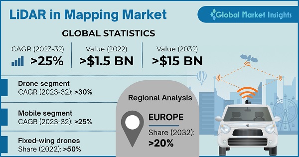
Lidar In Mapping Market #LiDARMapping #GeospatialTech #3DMapping #SurveyingTech #AutonomousMapping marketresearchfuture.com/reports/lidar-…
marketresearchfuture.com
LiDAR in Mapping Market Size, Share Report and Growth 2034
LiDAR in Mapping Market is expected to grow USD 30.10 Billion at 10.49% CAGR by 2034, Global LiDAR in Mapping Industry Analysis by Application, Technology, End Use, Component, Region

LiDAR That Powers Precision: From raw point clouds to classified data, our LiDAR services enable utilities, planners, and surveyors to work with accurate topographic intelligence. For more information Visit our website:- designpresentation.com #LiDARMapping #UtilitySurveys

Our team with AFAD will use airborne LiDAR to map ruptured faults in SE Turkey after the earthquake. The data will aid in relief efforts and future risk evaluation. #EarthquakeRecovery #LiDARMapping #SETurkey
Tim Webster at the @GeoIgnite conference where he'll be sharing his expertise on #lidarmapping to solve coastal problems and support sustainable development #NSCCresearcherinOttawa
Contact Us: [email protected] or WhatsApp 0722200616 #DroneSurvey #AerialSurvey #LiDARMapping #GeospatialTech #RemoteSensing #GIS #UAVMapping #Surveying #3DMapping #TopographicSurvey #MappingAfrica #RamaniGeosystems
$CYBL @MDSAdvisor “NURK” on the Tech Advisory Board & Chief Test Pilot is a Revenue Game Changer for the @CyberluxC Drone UAV Program, especially with 5G & AI Flight Technology: #DOD #LidarMapping #MilitaryGradeSystems #EyeInTheSky #GeoFencing #InfraredNightVision #ThermalSensor
Come to see our latest #utilitymapping #99%accurate #LiDARCloud & #LiDARmapping solutions at the #InternationalLiDARMappingForum @ILMF17

Korean LiDAR Startup SOS Lab Raises $6M #AerialData #LiDAR #LIDARmapping #Mapping #SOSLab @soslab2016 dronebelow.com/2018/10/11/kor…
Our geomatics research lidar team is gearing up to take flight over Sable Island. They'll be capturing topo lidar data and orthophotos to explore and map this unique landscape. Stay tuned for more updates from the skies! #AGRG #LidarMapping #SableIsland #ResearchInAction
Did you know that GPI Geospatial provides high accuracy railroad mapping? Check out our Riegl VMX-450 mounted on a customized truck for rail corridor mapping. #gpigeospatial #lidarmapping #railroadmapping
After a demo with the @flyability #Elios3 at @theohiostateuniversity, we helped at a campus fundraiser with a demonstration that showed the Elios 3 commands and a live stream to attendees of the #LiDARMapping capabilities while flying inside.
Visual inspection is a common method of quality control, data acquisition, and data analysis. Send us an e-mail: [email protected] #UMInspections #LIDARMapping

The LiDAR in mapping market is anticipated to surpass USD 15 billion revenue by 2032, witnessing 25% CAGR. Find more insights @ bit.ly/3gRpYY7 #lidar #lidarmapping #drones #corridormapping #gmi


Something went wrong.
Something went wrong.
United States Trends
- 1. Baker 41.2K posts
- 2. 49ers 38.8K posts
- 3. Ty Dillon N/A
- 4. Packers 35K posts
- 5. Bucs 13K posts
- 6. #TNABoundForGlory 12.5K posts
- 7. #BNBdip N/A
- 8. Fred Warner 14.6K posts
- 9. Lions 43.4K posts
- 10. Flacco 12.9K posts
- 11. Cowboys 76.5K posts
- 12. Niners 6,138 posts
- 13. Byron 6,149 posts
- 14. #OnePride 2,048 posts
- 15. George Springer 1,785 posts
- 16. #FTTB 4,681 posts
- 17. Zac Taylor 3,457 posts
- 18. Cam Ward 3,204 posts
- 19. Egbuka 7,106 posts
- 20. #GoPackGo 4,341 posts