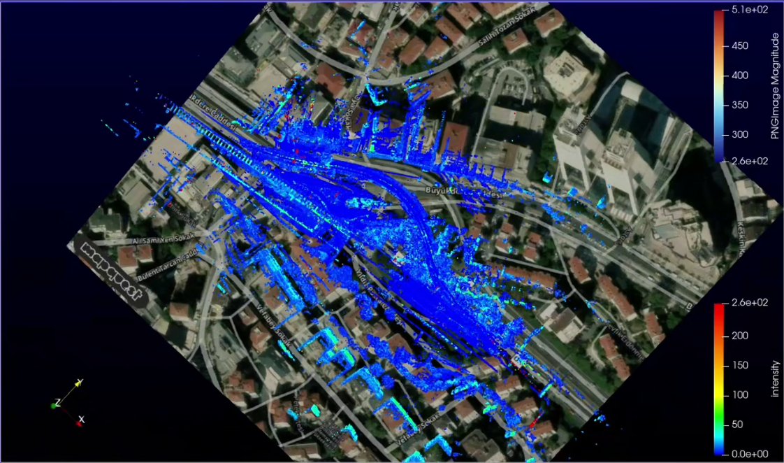
#lidar search results

LiDAR機能のあるiPhone17proを分解して、85マイクロドローンに載せ、狭隘部点検に利用してる人がいるとか。 ホントかな? 外部との通信さえ切っておけば日本でも電波法上は問題なさそうだけど。 #LiDAR #3dgs

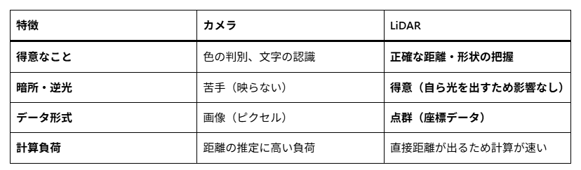
フィジカルAIにおいて、LiDARとカメラの役割は明確に異なります。 カメラが何があるか(物体検知)を判断するのに対し、LiDARはどこに、どのような形で存在するか(空間把握)を確定させる役割を担い、以下の表のような違いがあります。 #フィジカルAI #LiDAR #カメラ

What Are the Advantages of LiDAR with Drones? Listen to this episode➡️ hubs.ly/Q049DknZ0 where we take a closer look at why LiDAR is a powerful tool for aerial mapping. #LiDAR #mapping #photogrammetry #Correlator3D #drones

Mapping Dense Plantations with LiDAR 🌴 In a palm oil estate case study, DJI Zenmuse L3 captures LiDAR data and supports accurate as-built models, improving mapping in dense vegetation. 🎬 @halorobotics #djienterprise #lidar #mapping

Innoviz Technologies Launches InnovizTwo Ultra Long-Range (ULR) #LiDAR, Delivering up to 1-Kilometer Sensing to Power Next-Generation Physical AI for #Automotive and SMART Applications buff.ly/DZz4Pyn


Done. What should we map next? Try our aerial LiDAR and #photogrammetry services today. Too much vegetation and undergrowth? No problem. Our #LiDAR sensors (Zenmuse L2 and L3) were designed exactly for that. The L3 payload features up to 16 laser returns, enabling it to penetrate


Interactive projection powered by PoE LiDAR Every touch triggers dynamic visual effects Animals, flowers, music, and animated characters come alive Engaging, immersive, and memorable for visitors Designed for modern exhibition and experience spaces poelidar.com #LiDAR

🧠 Northstar+Lumen h-AI™ | Forensic X-Post Canonical Ledger Entry Title: Utility Truck with Roof-Mounted Light Array — Photonics / LiDAR Plausibility Assessment Timestamp: March 23, 2021 | Santa Barbara, CA (702) Tags: #Photonics #LiDAR #UtilityVehicles #Optics

Perform land surveys more rapidly. Download our quick guide➡️ hubs.ly/Q03F5rF_0 and learn how a high-end software can help you generate accurate maps. #LiDAR #mapping #photogrammetry #Correlator3D #drones

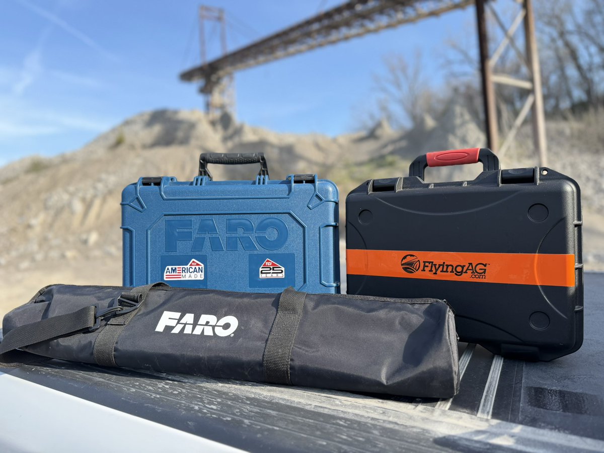
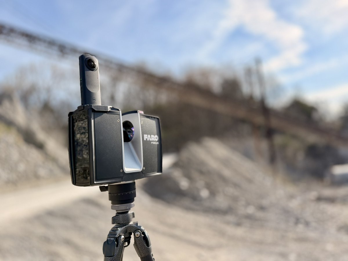
Last Saturday in Las Vegas with the team at @TCIMFG booth during @conexpoconagg 2026. This Saturday morning: @faro_building scanner on the ground @FlyingAGUAV @DJIGlobal drone in the air From trade show floor ➝ real world in one week. #LiDAR #Drones #FlyingAg


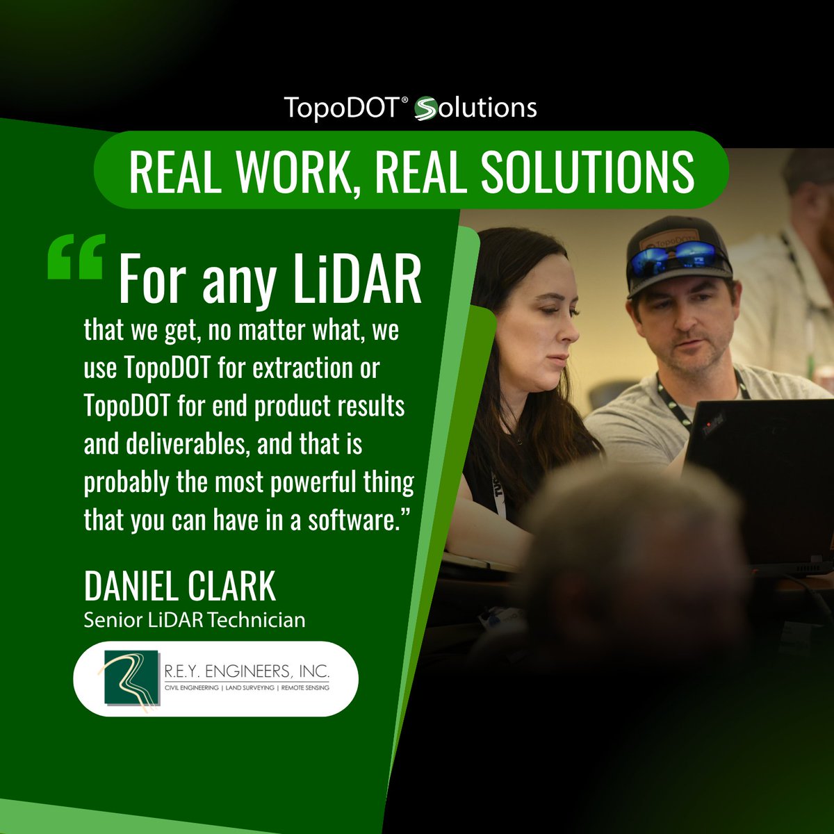
The best software ideas come from the field. Feedback from users like Daniel Clark of R.E.Y. Engineering has helped shape TopoDOT for LiDAR extraction and deliverables. Thank you to our user community for continuing to shape what comes next. #LiDAR #Surveying #TopoDOT

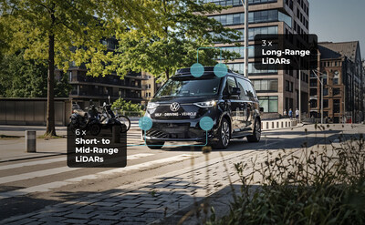
$INVZ #LIDAR $UBER #Volkswagen #MOIA Innoviz Technologies Accelerates LiDAR Integration to Power Volkswagen’s Autonomous ID. Buzz Fleet Innoviz supplies nine InnovizTwo LiDAR sensors per ID. Buzz AD autonomous shuttle, enabling 360° urban sensing for Volkswagen’s Level 4

Urban #LiDAR struggles in cities because of data gaps. Hidden objects, weak detail at distance, and noisy signals all impact detection. Fixing it means better coverage, cleaner annotation, and aligned sensor data. Read: imerit.net/resources/blog… #AutonomousDriving #ComputerVision


Sivers’ strategic LiDAR customer is ramping remote production from Q4 2026, using Sivers’ CW DFB lasers and optical amplifiers for automotive and industrial applications. Lifecycle revenue potential of 53-138 MUSD. Learn more: #LiDAR #Photonics sivers-semiconductors.com/press/strategi…


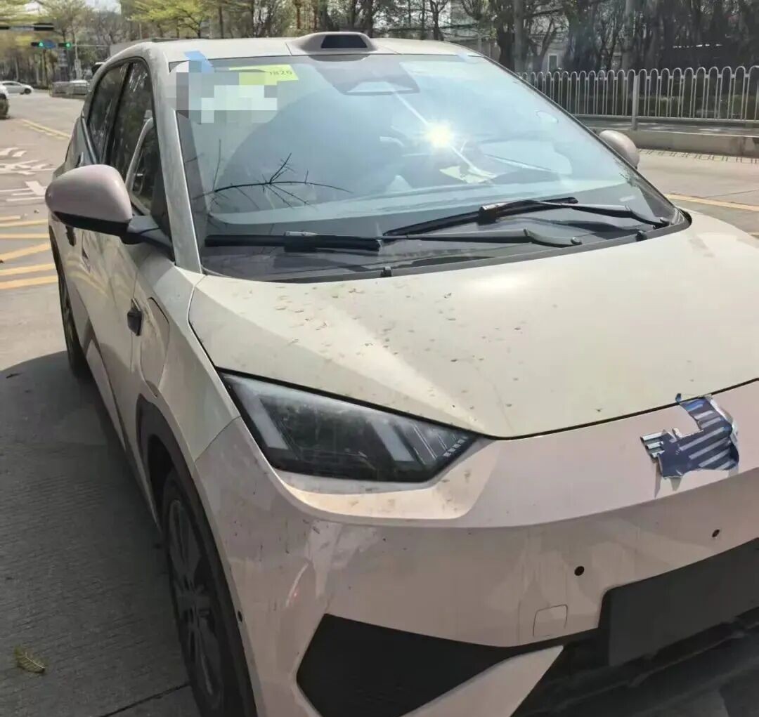
BYD's entry-level model Seagull equipped with LiDAR debuted at the Beijing Auto Show. In addition to the roof-mounted LiDAR, the rear features the "Eye of God B" badge and a small blue light representing intelligent driving. #BYD #BYDSeagull #LiDAR #BeijingAutoShow


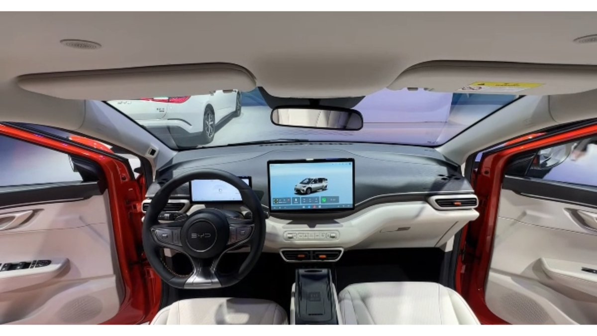
#BYD Seagull has been spotted in real-world photos as a LiDAR variant. Spy shots reveal the exterior design remains largely unchanged from the current model, with the only update being a roof-mounted LiDAR.
DJI Zenmuse L3 P1による計測業務を実施しました。 ・広範囲の高速測量 ・植生下の地形取得 ・高精度な3Dデータ化 これらをワンストップで対応可能です。 測量・調査・インフラ点検など、ドローンの活用をご検討の方はお気軽にご相談ください。 #ドローン業務 #LiDAR #空間データ #業務効率化

Next-gen sensing is here 🌐 FMCW LiDAR adoption is rising with OEM integration, enabling precise real-time perception in vehicles. #LiDAR #Innovation #ADAS #PlaneteyeInfraAI

🍵 @KeilafOmer is spilling the tea on the #LiDAR industry's dirty secrets. Most LiDAR technologies aren't built for the real world. The engineering that makes Innoviz the trusted choice for automotive OEMs is now powering LiDAR applications. 👉 innoviz.tech/physical-ai

Suyodhan_LIDARFloating LiDAR Buoy - The Floating LiDAR Buoy System is a high-tech ocean-based instrument used to measure wind conditions over the sea. #LiDAR #Ocean #UPSC #SavalAI


NIO supplier Seyond has hit a major milestone, with cumulative LiDAR deliveries now surpassing 1 million units. #LiDAR #ChinaEV chinaevhome.com/2026/04/10/nio…

Innoviz Technologies Launches InnovizTwo Ultra Long-Range (ULR) #LiDAR, Delivering up to 1-Kilometer Sensing to Power Next-Generation Physical AI for #Automotive and SMART Applications buff.ly/DZz4Pyn
Perform land surveys more rapidly. Download our quick guide➡️ hubs.ly/Q03F5rF_0 and learn how a high-end software can help you generate accurate maps. #LiDAR #mapping #photogrammetry #Correlator3D #drones
フィジカルAIにおいて、LiDARとカメラの役割は明確に異なります。 カメラが何があるか(物体検知)を判断するのに対し、LiDARはどこに、どのような形で存在するか(空間把握)を確定させる役割を担い、以下の表のような違いがあります。 #フィジカルAI #LiDAR #カメラ

IIT #Roorkee developing guidelines for assessing hillslope instability . DPRs for hill roads will incorporate landslide susceptibility maps, historical failure data and high-resolution terrain models. Tools such as #LiDAR and #drones will be used for better route planning.
THDC India will assist with landslide remediation Defence Geo-informatics Research Establishment will contribute to hazard mapping. #GSI will provide geological data -tunnel & corridor National Institute of Rock Mechanics will handle design reviews @PMOIndia @PSTamangGolay
LiDAR機能のあるiPhone17proを分解して、85マイクロドローンに載せ、狭隘部点検に利用してる人がいるとか。 ホントかな? 外部との通信さえ切っておけば日本でも電波法上は問題なさそうだけど。 #LiDAR #3dgs
What Are the Advantages of LiDAR with Drones? Listen to this episode➡️ hubs.ly/Q049DknZ0 where we take a closer look at why LiDAR is a powerful tool for aerial mapping. #LiDAR #mapping #photogrammetry #Correlator3D #drones

Tutorial: What is spectral resolution? How does the number of bands affect satellite image information? To get the full tutorial, comment #remotesensing #GIS #LiDAR #Radar #optical #SatelliteImagery #EarthObservation #geospatial #SpatialAnalysis #LearnGIS
Interactive projection powered by PoE LiDAR Every touch triggers dynamic visual effects Animals, flowers, music, and animated characters come alive Engaging, immersive, and memorable for visitors Designed for modern exhibition and experience spaces poelidar.com #LiDAR
Next-gen sensing is here 🌐 FMCW LiDAR adoption is rising with OEM integration, enabling precise real-time perception in vehicles. #LiDAR #Innovation #ADAS #PlaneteyeInfraAI
Urban #LiDAR struggles in cities because of data gaps. Hidden objects, weak detail at distance, and noisy signals all impact detection. Fixing it means better coverage, cleaner annotation, and aligned sensor data. Read: imerit.net/resources/blog… #AutonomousDriving #ComputerVision
Types of Remote Sensing Sensors Explained | Optical, Radar & LiDAR. (Beginner to Advanced Guide) To get the full tutorial, Link:youtu.be/iyTzO4S5Ygg?si… Registration details are attached in the comment. #RemoteSensing #GIS #LiDAR #Radar #Optical #SatelliteImagery

🔹 Se déplacer sans voir l’écran ne devrait pas être un pari. EchoNav est une app gratuite de navigation pour malvoyants qui utilise le LiDAR de l’iPhone pour détecter les obstacles en temps réel. echonav-landing.pages.dev #Accessibility #BlindTech #LiDAR

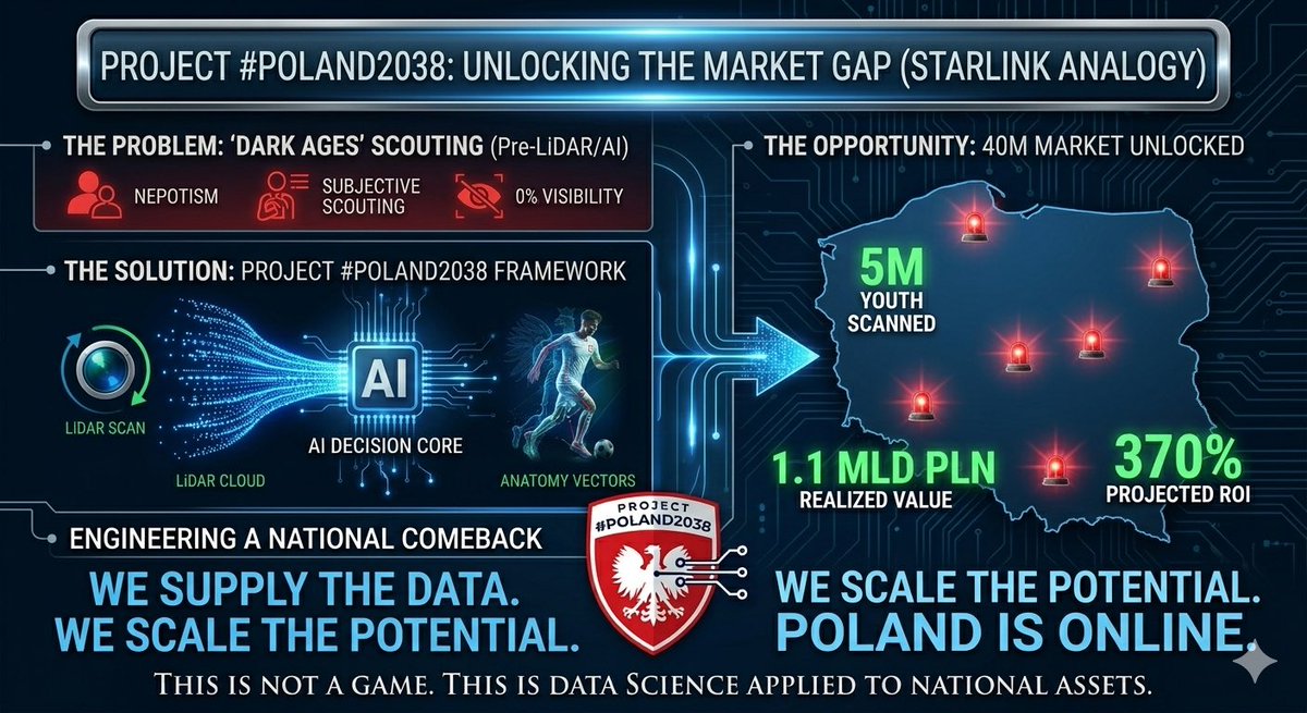
Meritocracy at scale requires infrastructure, not just algorithms. Data without ground-truth is noise. We engineer the dataset. 🛡️📊 #Polska2038 #LiDAR #DataScience #TalentArbitrage #AI
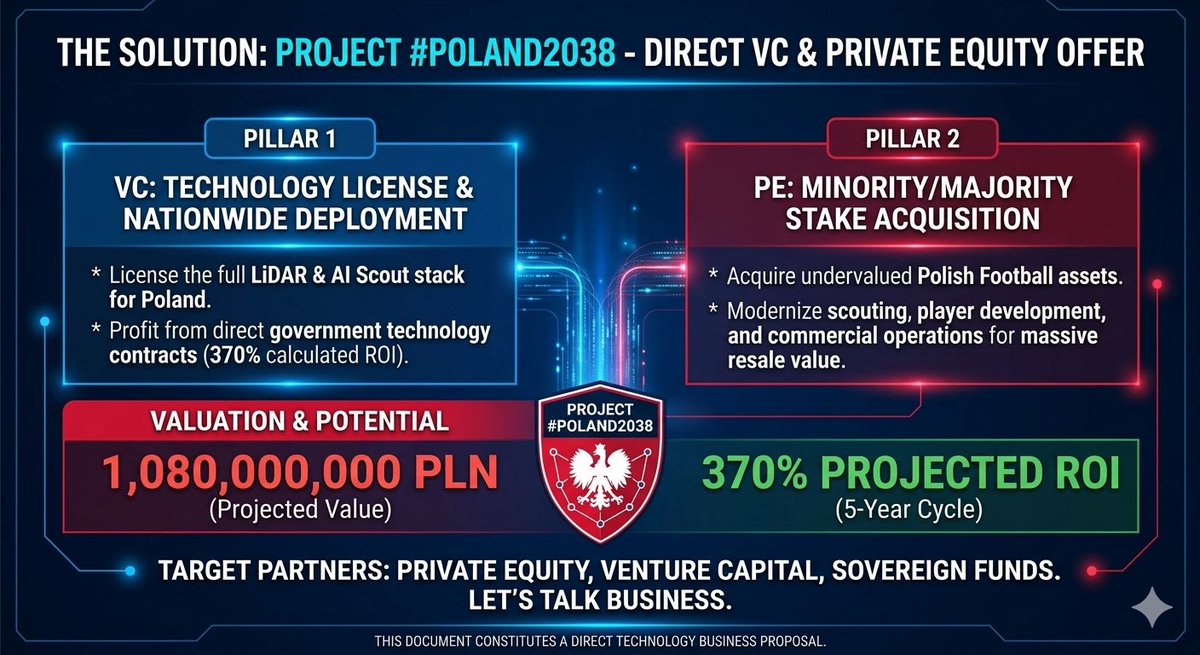
@pzpn_pl @KubaRutnicki @Czarek_Kulesza Czy PZPN jest gotowy na rewolucję w scouting? LiDAR ground-truth data dla 5M polskich zawodników to nie przyszłość — to infrastruktura, którą budujemy dziś. Czas przestać zgadywać i zacząć mierzyć. 🇵🇱🚀 #Polska2038 #LiDAR #TalentArbitrage
🧠 Northstar+Lumen h-AI™ | Forensic X-Post Canonical Ledger Entry Title: Utility Truck with Roof-Mounted Light Array — Photonics / LiDAR Plausibility Assessment Timestamp: March 23, 2021 | Santa Barbara, CA (702) Tags: #Photonics #LiDAR #UtilityVehicles #Optics
The best software ideas come from the field. Feedback from users like Daniel Clark of R.E.Y. Engineering has helped shape TopoDOT for LiDAR extraction and deliverables. Thank you to our user community for continuing to shape what comes next. #LiDAR #Surveying #TopoDOT

Wearable #LiDAR Spatial Audio Navigator for Visually-Impaired Individuals Built with a ...CLICK TO READ MORE circuitcellar.com/research-desig… #assistivetechnology #DSP #embeddedsystems #spatialaudio #accessibility #WearableTech #RaspberryPiPico

1 Flight. 7 Outputs 🔄 One LiDAR mission with DJI Zenmuse L3 and Matrice 400 can generate point clouds, meshes, terrain models, and more, maximizing data from every flight. #djienterprise #lidar #mapping
This is what our users are saying about Correlator3D ensuring consistent results. Learn more about the solution➡️ hubs.ly/Q04f6J2Z0 #LiDAR #mapping #photogrammetry #Correlator3D #drones


Last Saturday in Las Vegas with the team at @TCIMFG booth during @conexpoconagg 2026. This Saturday morning: @faro_building scanner on the ground @FlyingAGUAV @DJIGlobal drone in the air From trade show floor ➝ real world in one week. #LiDAR #Drones #FlyingAg
Done. What should we map next? Try our aerial LiDAR and #photogrammetry services today. Too much vegetation and undergrowth? No problem. Our #LiDAR sensors (Zenmuse L2 and L3) were designed exactly for that. The L3 payload features up to 16 laser returns, enabling it to penetrate

💧🌿 ANN-Based Filtering of #Drone #LiDAR in Coastal #SaltMarshes Using Spatial–Spectral #Features ✍️ Kunbo Liu et al. 🔗 brnw.ch/21x0OrT

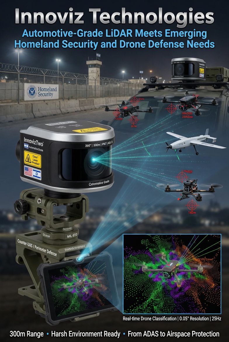
$INVZ #LIDAR #Drone #Security #DefenseSpending : Innoviz Technologies: Automotive-Grade LiDAR Meets Emerging Homeland Security and Drone Defense Needs Innoviz’s automotive-grade LiDAR sensors deliver long-range, high-resolution 3D point clouds with ruggedness suitable for
👉👉 Fusing #LiDAR and #Photogrammetry for Accurate #3D #Data: A Hybrid Approach ✍️ Rytis Maskeliūnas et al. 🔗 brnw.ch/21x1nYJ

DJI Zenmuse L3 P1による計測業務を実施しました。 ・広範囲の高速測量 ・植生下の地形取得 ・高精度な3Dデータ化 これらをワンストップで対応可能です。 測量・調査・インフラ点検など、ドローンの活用をご検討の方はお気軽にご相談ください。 #ドローン業務 #LiDAR #空間データ #業務効率化
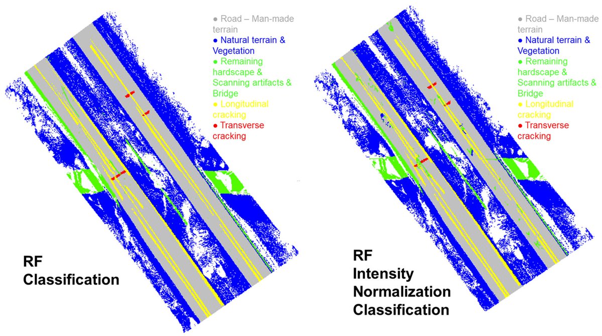
👉👉 #LiDAR-Based #Road Cracking Detection: #MachineLearning Comparison, Intensity Normalization, and Open-Source #WebGIS for #Infrastructure Maintenance ✍️ Nicole Pascucci et al. 🔗 brnw.ch/21x1GL7
Revealing the Mirador Basin with LiDAR 🔍 Using DJI Matrice 400 and Zenmuse L3 LiDAR, researchers are mapping the Mirador Basin and uncovering ancient Maya structures hidden beneath dense jungle. Watch here 👉 brnw.ch/21x1Qyw #djienterprise #lidar #archaeology


BYD's entry-level model Seagull equipped with LiDAR debuted at the Beijing Auto Show. In addition to the roof-mounted LiDAR, the rear features the "Eye of God B" badge and a small blue light representing intelligent driving. #BYD #BYDSeagull #LiDAR #BeijingAutoShow
#BYD Seagull has been spotted in real-world photos as a LiDAR variant. Spy shots reveal the exterior design remains largely unchanged from the current model, with the only update being a roof-mounted LiDAR.
🌳🏙️🌳 Comparison of #UAV-Based #LiDAR and #Photogrammetric Point Cloud for Individual #Tree Species Classification of #Urban Areas ✍️ Qixia Man et al. 🔗 brnw.ch/21x1TQs

Development of a 2 μm Solid-State Laser for Lidar in the Past Decade mdpi.com/1424-8220/23/1… Jilin Key Laboratory of Solid-State Laser Technology and Application, Changchun University of Science and Technology #all_solid_state_laser #lidar


A very detailed shaded map of Yokohama, Japan. The full map is 24780 x 24532 pixels with 0.5 m resolution and is available at shadedmaps.github.io Data source: geospatial.jp [Kanagawa Prefecture General Affairs Bureau Digital Strategy Headquarters Office]. #lidar
![ShadedMaps's tweet image. A very detailed shaded map of Yokohama, Japan. The full map is 24780 x 24532 pixels with 0.5 m resolution and is available at shadedmaps.github.io
Data source: geospatial.jp [Kanagawa Prefecture General Affairs Bureau Digital Strategy Headquarters Office].
#lidar](https://pbs.twimg.com/media/HCo9xHkWEAA-5PJ.jpg)
![ShadedMaps's tweet image. A very detailed shaded map of Yokohama, Japan. The full map is 24780 x 24532 pixels with 0.5 m resolution and is available at shadedmaps.github.io
Data source: geospatial.jp [Kanagawa Prefecture General Affairs Bureau Digital Strategy Headquarters Office].
#lidar](https://pbs.twimg.com/media/HCo9xyiXcAA6xux.jpg)
![ShadedMaps's tweet image. A very detailed shaded map of Yokohama, Japan. The full map is 24780 x 24532 pixels with 0.5 m resolution and is available at shadedmaps.github.io
Data source: geospatial.jp [Kanagawa Prefecture General Affairs Bureau Digital Strategy Headquarters Office].
#lidar](https://pbs.twimg.com/media/HCo9yVVboAA5D4R.jpg)
![ShadedMaps's tweet image. A very detailed shaded map of Yokohama, Japan. The full map is 24780 x 24532 pixels with 0.5 m resolution and is available at shadedmaps.github.io
Data source: geospatial.jp [Kanagawa Prefecture General Affairs Bureau Digital Strategy Headquarters Office].
#lidar](https://pbs.twimg.com/media/HCo9yrgWUAAhsrz.jpg)

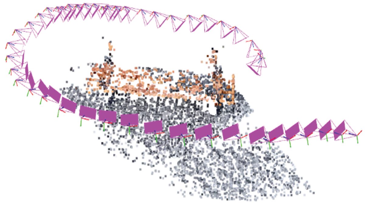
New updates to georeferenced SLAM in LidarView! From multi-sensor integration to improved calibration and map-based trajectory correction, we’re making 3D mapping more accurate and accessible. Learn more: ow.ly/ZmO250YFR7S #SLAM #Lidar #OpenSource #3DMapping
🌳🌳 Modelling #LiDAR-Based #Vegetation Geometry for Computational Fluid Dynamics #Heat #Transfer Models ✍️ Pirunthan Keerthinathan et al. 🔗 brnw.ch/21x1N9G

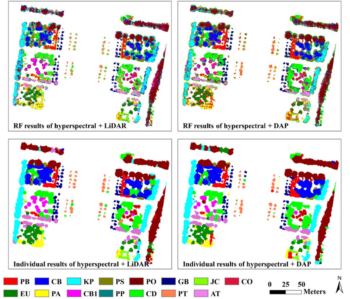
👋👋 Joint Classification of #Hyperspectral and #LiDAR #Data via Multiprobability Decision #Fusion Method ✍️ Tao Chen et al. 🔗 brnw.ch/21x14tW

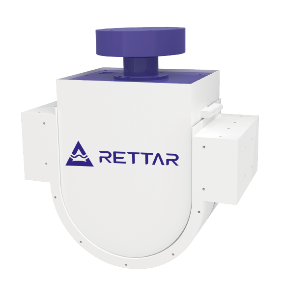
China's 3D #spatialsensing major #RETTAR offers #LiDAR scanners like the 3DPro2501 but also #radar options like the 3DPro2300. This allows it to provide it says effective silo & #stockpile scanning solutions regardless of material type or dust levels shorturl.at/hyknR

10 years. Thousands of laser pulses. One incredible team. 🎂 From our first prototype to seeing Innoviz tech on the road, it’s been a decade of making the invisible, visible. 🚗✨ Here’s to 10 more years of LiDAR innovation! 🥂 #LiDAR #FutureOfMobility #Tech #InnovizLife


🕌 Utilizando la información de nuestros sensores #LiDAR, el investigador Antonio Monterroso‑Checa (@Univcordoba) ha publicado la posible ubicación de Madinat al Zāhira, la ciudad de #Almanzor del siglo X 📍Se encontraría en el extremo este de #Córdoba, cerca de #Alcolea y a 12

Something went wrong.
Something went wrong.
United States Trends
- 1. Liverpool N/A
- 2. Joe Ryan N/A
- 3. Slot N/A
- 4. Carrick N/A
- 5. Amad N/A
- 6. #MUFC N/A
- 7. Manchester United N/A
- 8. #MUNLIV N/A
- 9. Sesko N/A
- 10. Kobbie Mainoo N/A
- 11. Good Sunday N/A
- 12. Zverev N/A
- 13. Amorim N/A
- 14. #MiamiGP N/A
- 15. Sinner N/A
- 16. Sunday Funday N/A
- 17. #SeductiveSunday N/A
- 18. Dalot N/A
- 19. Old Trafford N/A
- 20. Wirtz N/A