#maptiler search results

"Today, I learned 🖍️ how to implement a map in our Airbnb-style website using MapTiler . with the OpenLayers library! 🗺️ Now, locations are interactive and visually appealing. Excited to refine it further! #WebDevelopment #OpenLayers #MapTiler"


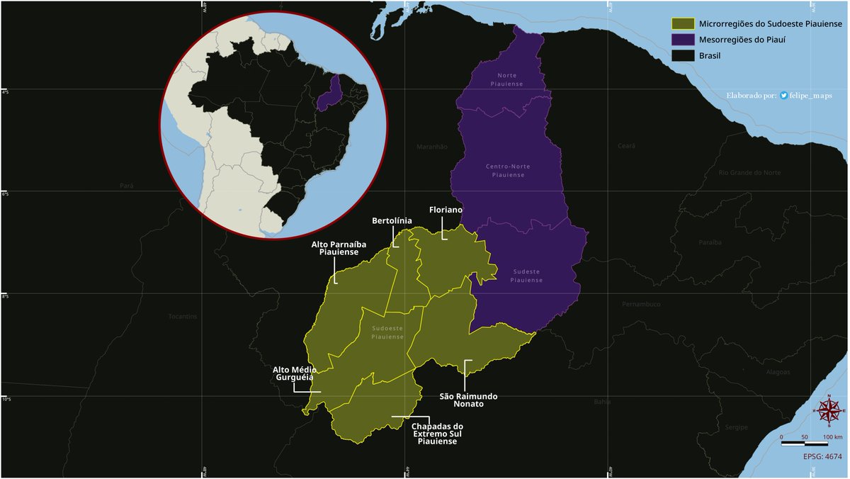
Mapa 🗺️ temático dos limites das microrregiões do Sudoeste Piauiense. Usei o #QGIS e trabalhei com 04 camadas vetoriais neste projeto: - UFs, Mesorregiões e Microrregiões do Piauí (#IBGE); - Mapa base (#MapTiler). #Piauí #Cartografia #QGIS #Maps

🗺️ MapLibre Tutorial 09: Display Videos on an Interactive Map 🌎 Video: youtu.be/Rnbr0-kuVws Playlist: bit.ly/maplibre Notebook: leafmap.org/maplibre/video… Demo: maps.gishub.org/maplibre/video… #geospatial #maptiler #maplibre #leafmap #python

The elevation function of MapTiler SDK provides you with elevation for any location. Compute elevation for a single point, a batch of points, GeoJSON LineString & MultiLineString, or display the elevation at a clicked location: maptiler.link/3WNOYk1 #MapTiler #SummerOfMaps

A final bonus: Since you're now a MapTiler SDK pro, our last tutorial is all about making the switch from Mapbox. Enjoy the ride! 🚀 maptiler.link/3X29IWn #MapTiler #SummerOfMaps


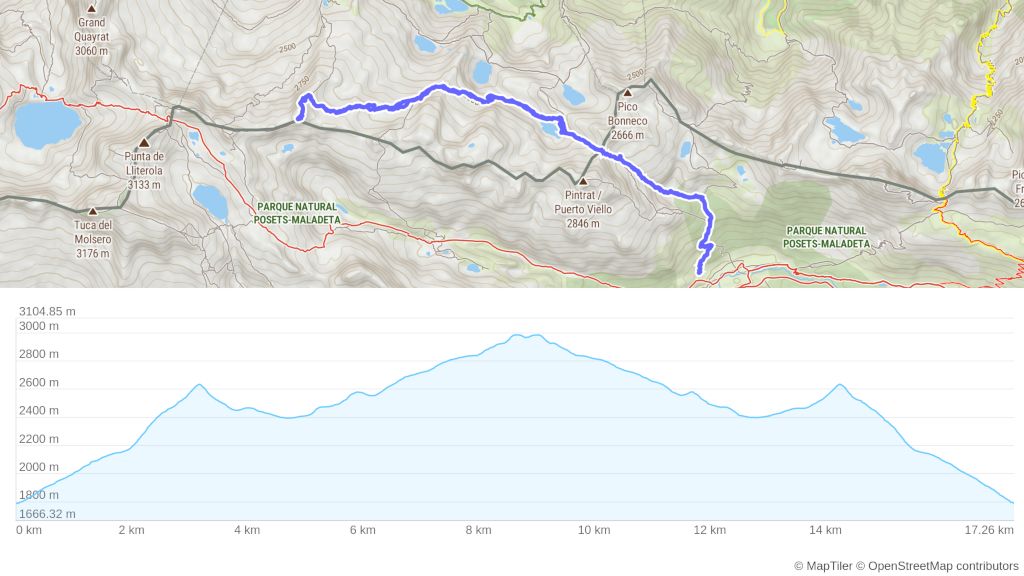
In the final week of our #SummerOfMaps, we'll dive into more complex tutorials. Today, learn how to display an elevation profile for a track uploaded as GeoJSON: maptiler.link/3YFUzeJ #MapTiler #SummerOfMaps

If I get 10 retweets @MapTiler will donate this cool tshirt to me. Please help @openmapping_ap @hotosm @YerCizenler @foss4g #foss4g2023 #maptiler #osm #hotosm


Today's tutorial covers how to read GeoJSON files locally without uploading them to a server. This approach saves on network transfer and can be useful for addressing security or privacy concerns. Learn more at maptiler.link/3LQ38vV #MapTiler #SummerOfMaps

The temperature layer provides an animated hourly forecast for the upcoming days. Discover how to use it at maptiler.link/4fIBi2g #MapTiler #SummerOfMaps

Learn how to activate a pop-up with additional information (loaded from Wikidata in our case) by clicking on a point of interest. maptiler.link/3yDcg3T #MapTiler #SummerOfMaps

Filter thousands of features in real-time to swiftly find those that match your search criteria using the Point Filtering by property: maptiler.link/3SPpamp #MapTiler #SummerOfMaps


国勢調査の総人口(3次メッシュ、1995~2020年の5年毎)をMapLibre GL JSで時系列アニメーションにしてみた。ポリゴン数は最大で18万。Out of Memory...にはならず📝 #MapLibre #MapTiler
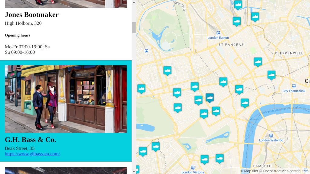
Today, we'll explore how to synchronize a map with a list of places: clicking a pin scrolls to the feature in the list, and selecting a list item highlights the pin on the map. Explore the tutorial here: maptiler.link/3yDc7xn #MapTiler #SummerOfMaps
This tutorial will show you how to add an external Web Map Service (WMS) raster layer to your map using the 'tiles' option from the 'addSource' function. It allows the integration of external content from the specified WMS URL: maptiler.link/4d9sf8L #MapTiler #SummerOfMaps
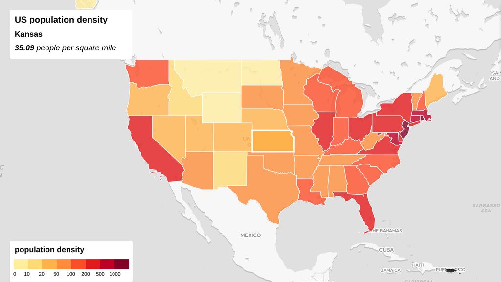
Create interactive choropleth maps; get inspired by this US population density map example: maptiler.link/3yLToQ8 #MapTiler #SummerOfMaps
Adding a new data layer might affect the map’s readability. By using the second parameter of the 'addLayer' function, you can position the new layer below labels and control its placement relative to other map layers. Learn more at maptiler.link/3LUCamA #MapTiler #SummerOfMaps

For a realistic representation of the terrain and shadows on your map, incorporate hillshading. This tutorial shows you how to do it using the raster digital elevation model dataset. Learn more at maptiler.link/46AN9v8 #MapTiler #SummerOfMaps

今日のXYZタイル生成実習用に MapTiler Engine の無料版をインストールしてください。ダウンロード前に簡単なフォーム入力が必要です。 #sa2025jp #MapTiler #古橋研究室
今日のXYZタイル生成実習用に MapTiler Engine の無料版をインストールしてください。ダウンロード前に簡単なフォーム入力が必要です。 #sa2025jp #MapTiler #古橋研究室 maptiler.com/engine/downloa…
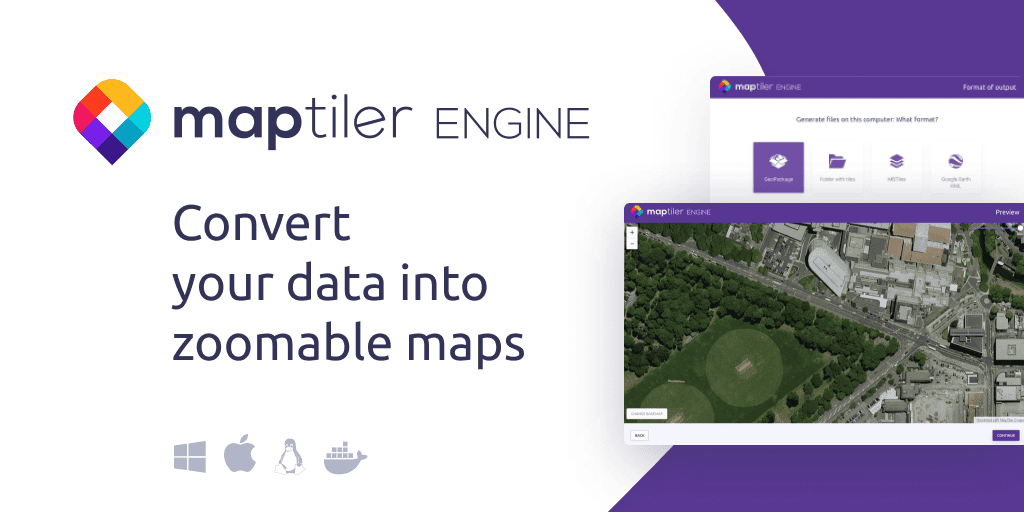
今日のXYZタイル生成実習用に MapTiler Engine の無料版をインストールしてください。ダウンロード前に簡単なフォーム入力が必要です。 #sa2025jp #MapTiler #古橋研究室 maptiler.com/engine/downloa…

🗺️ Today I learned how to integrate MapTiler API with Leaflet.js to show dynamic maps on my webpage! Used geocoding to fetch coordinates Fallback to country if location fails Added marker + radius highlight Custom popup on hover! @ApnacollegeX #WebDev #MapTiler #LeafletJS


🎉 A long-time contributor to open-source mapping, @MapTiler joins MapLibre as a silver sponsor 🌍 Read more 👉 maplibre.org/news/2025-03-3… #MapLibre #MapTiler #OpenSource #GIS #OpenStreetMap

"Today, I learned 🖍️ how to implement a map in our Airbnb-style website using MapTiler . with the OpenLayers library! 🗺️ Now, locations are interactive and visually appealing. Excited to refine it further! #WebDevelopment #OpenLayers #MapTiler"

Das Schweizer Unternehmen @MapTiler entwickelt B2B-Kartensoftware und hat sich als ein führender Anbieter von Basemaps etabliert. 🗺️ Erfahrt, wie #MapTiler es dank der #PublicCloud Services von @OVHcloud schafft, Karten zu erstellen, die jeden Tag 400 Millionen Zugriffe haben. 📈
A final bonus: Since you're now a MapTiler SDK pro, our last tutorial is all about making the switch from Mapbox. Enjoy the ride! 🚀 maptiler.link/3X29IWn #MapTiler #SummerOfMaps
Learn how to activate a pop-up with additional information (loaded from Wikidata in our case) by clicking on a point of interest. maptiler.link/3yDcg3T #MapTiler #SummerOfMaps
Today, we'll explore how to synchronize a map with a list of places: clicking a pin scrolls to the feature in the list, and selecting a list item highlights the pin on the map. Explore the tutorial here: maptiler.link/3yDc7xn #MapTiler #SummerOfMaps
Filter thousands of features in real-time to swiftly find those that match your search criteria using the Point Filtering by property: maptiler.link/3SPpamp #MapTiler #SummerOfMaps
Create interactive choropleth maps; get inspired by this US population density map example: maptiler.link/3yLToQ8 #MapTiler #SummerOfMaps
The elevation function of MapTiler SDK provides you with elevation for any location. Compute elevation for a single point, a batch of points, GeoJSON LineString & MultiLineString, or display the elevation at a clicked location: maptiler.link/3WNOYk1 #MapTiler #SummerOfMaps
In the final week of our #SummerOfMaps, we'll dive into more complex tutorials. Today, learn how to display an elevation profile for a track uploaded as GeoJSON: maptiler.link/3YFUzeJ #MapTiler #SummerOfMaps
Learn how to build a simple weather app featuring a layer switcher, allowing you to toggle between different weather layers seamlessly—even while the animation is playing. Check out the tutorial at maptiler.link/3M700Mi #MapTiler #SummerOfMaps #WeatherMaps

Today's example demonstrates how to create custom popups displaying wind, temperature, and precipitation data from various layers of the MapTiler Weather JS module. Learn how at maptiler.link/46IT2qd #MapTiler #SummerOfMaps #WeatherMaps
Display wind direction and speed on your map with an impressive 60 frames per second animation. Additionally, you can display wind speed and direction at any location under the cursor. Learn how at maptiler.link/4fYbPSL #MapTiler #SummerOfMaps #WeatherMaps
The temperature layer provides an animated hourly forecast for the upcoming days. Discover how to use it at maptiler.link/4fIBi2g #MapTiler #SummerOfMaps
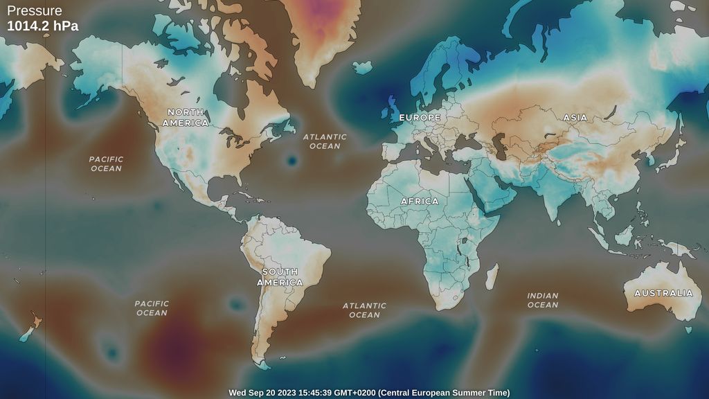
Air pressure can influence our health and well-being, especially for those sensitive to its changes. With the Atmospheric Pressure layer, you can add a four-day forecast to your web maps or apps. Learn how at maptiler.link/4fLpA76 #MapTiler #SummerOfMaps #WeatherMaps
Advanced weather users will appreciate the Radar dataset, which shows cloud reflectivity animated over time. As a bonus, this tutorial also demonstrates how to display radar data under the mouse pointer. Learn more at maptiler.link/3YLTjXy #MapTiler #SummerOfMaps #WeatherMaps

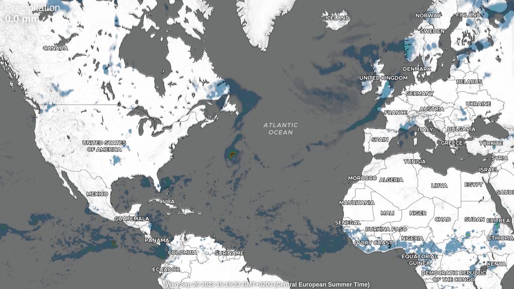
Enrich your web maps with the #weather! This week, we’re highlighting the Weather JS module, the free plugin in the MapTiler SDK, starting with a precipitation layer. Check out the tutorial at maptiler.link/3YLa30W #MapTiler #SummerOfMaps #WeatherMaps


"Today, I learned 🖍️ how to implement a map in our Airbnb-style website using MapTiler . with the OpenLayers library! 🗺️ Now, locations are interactive and visually appealing. Excited to refine it further! #WebDevelopment #OpenLayers #MapTiler"
If I get 10 retweets @MapTiler will donate this cool tshirt to me. Please help @openmapping_ap @hotosm @YerCizenler @foss4g #foss4g2023 #maptiler #osm #hotosm
The elevation function of MapTiler SDK provides you with elevation for any location. Compute elevation for a single point, a batch of points, GeoJSON LineString & MultiLineString, or display the elevation at a clicked location: maptiler.link/3WNOYk1 #MapTiler #SummerOfMaps
Mapa 🗺️ temático dos limites das microrregiões do Sudoeste Piauiense. Usei o #QGIS e trabalhei com 04 camadas vetoriais neste projeto: - UFs, Mesorregiões e Microrregiões do Piauí (#IBGE); - Mapa base (#MapTiler). #Piauí #Cartografia #QGIS #Maps
🗺️ Today I learned how to integrate MapTiler API with Leaflet.js to show dynamic maps on my webpage! Used geocoding to fetch coordinates Fallback to country if location fails Added marker + radius highlight Custom popup on hover! @ApnacollegeX #WebDev #MapTiler #LeafletJS
A final bonus: Since you're now a MapTiler SDK pro, our last tutorial is all about making the switch from Mapbox. Enjoy the ride! 🚀 maptiler.link/3X29IWn #MapTiler #SummerOfMaps
Create interactive choropleth maps; get inspired by this US population density map example: maptiler.link/3yLToQ8 #MapTiler #SummerOfMaps
The temperature layer provides an animated hourly forecast for the upcoming days. Discover how to use it at maptiler.link/4fIBi2g #MapTiler #SummerOfMaps
In the final week of our #SummerOfMaps, we'll dive into more complex tutorials. Today, learn how to display an elevation profile for a track uploaded as GeoJSON: maptiler.link/3YFUzeJ #MapTiler #SummerOfMaps
Learn how to activate a pop-up with additional information (loaded from Wikidata in our case) by clicking on a point of interest. maptiler.link/3yDcg3T #MapTiler #SummerOfMaps
Filter thousands of features in real-time to swiftly find those that match your search criteria using the Point Filtering by property: maptiler.link/3SPpamp #MapTiler #SummerOfMaps
Today's tutorial covers how to read GeoJSON files locally without uploading them to a server. This approach saves on network transfer and can be useful for addressing security or privacy concerns. Learn more at maptiler.link/3LQ38vV #MapTiler #SummerOfMaps
Today, we'll explore how to synchronize a map with a list of places: clicking a pin scrolls to the feature in the list, and selecting a list item highlights the pin on the map. Explore the tutorial here: maptiler.link/3yDc7xn #MapTiler #SummerOfMaps
This tutorial will show you how to add an external Web Map Service (WMS) raster layer to your map using the 'tiles' option from the 'addSource' function. It allows the integration of external content from the specified WMS URL: maptiler.link/4d9sf8L #MapTiler #SummerOfMaps
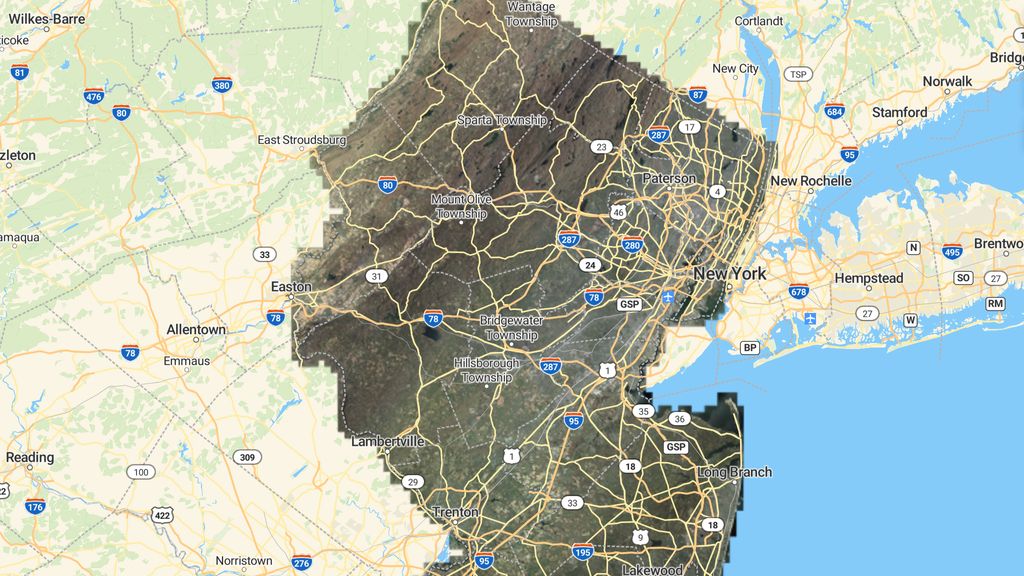
This week's tutorials will focus on enhancing your maps with geographical data from external sources. Today's tutorial offers step-by-step instructions on adding a raster image overlay to your map, such as drone imagery: maptiler.link/4cfUqBL #MapTiler #SummerOfMaps

For a realistic representation of the terrain and shadows on your map, incorporate hillshading. This tutorial shows you how to do it using the raster digital elevation model dataset. Learn more at maptiler.link/46AN9v8 #MapTiler #SummerOfMaps
Adding a new data layer might affect the map’s readability. By using the second parameter of the 'addLayer' function, you can position the new layer below labels and control its placement relative to other map layers. Learn more at maptiler.link/3LUCamA #MapTiler #SummerOfMaps
Enrich your web maps with the #weather! This week, we’re highlighting the Weather JS module, the free plugin in the MapTiler SDK, starting with a precipitation layer. Check out the tutorial at maptiler.link/3YLa30W #MapTiler #SummerOfMaps #WeatherMaps
Something went wrong.
Something went wrong.
United States Trends
- 1. #GMMTV2026 2.64M posts
- 2. Good Tuesday 29.6K posts
- 3. MILKLOVE BORN TO SHINE 423K posts
- 4. #tuesdayvibe 2,200 posts
- 5. WILLIAMEST MAGIC VIBES 58K posts
- 6. Mark Kelly 216K posts
- 7. Chelsea 220K posts
- 8. MAGIC VIBES WITH JIMMYSEA 70.1K posts
- 9. JOSSGAWIN MAGIC VIBES 23.4K posts
- 10. Alan Dershowitz 3,296 posts
- 11. TOP CALL 9,434 posts
- 12. #JoongDunk 104K posts
- 13. AI Alert 8,291 posts
- 14. Naps 2,882 posts
- 15. #ONEPIECE1167 8,591 posts
- 16. Barca 84.8K posts
- 17. Check Analyze 2,502 posts
- 18. Token Signal 8,664 posts
- 19. Maddow 15.5K posts
- 20. Jim Croce N/A