#pix4dmapper search results

Nuevo ATygeo Thermal para cámaras DJI Zenmuse H30T. Crea ortomosaicos térmicos radiométricos de una manera simple y sencilla. New version of ATygeo Thermal for #ZenmuseH30T is now available. Create radiometric orthomosaics in a simple way. #pix4dmapper @pix4d @DJIEnterprise

When it comes to transforming aerial images into highly accurate 2D maps and 3D models, PIX4Dmapper is the go-to solution for surveyors, engineers, and GIS professionals. #SurveyDronesIreland #PIX4Dmapper #DroneMapping #Photogrammetry #SurveyingSoftware #GIS #3DMapping
Transform your aerial data into actionable insights with industry-leading photogrammetry software. Whether you're in surveying, construction, or agriculture, #Pix4D has the tools you need. [email protected] #Pix4DCapture #Pix4DMapper #Pix4DSurvey #CAD #Pix4DCatch
Accurate, reliable mapping starts with the right software — and #Pix4Dmapper continues to set the standard for drone-based photogrammetry. [email protected] #DroneMapping #AerialSurveying #SurveyDronesIreland #PhotogrammetryTraining #MappingSoftware


... al nostre LAB tenim el millor equipament pel post-processat... apostem sempre per la QUALITAT [email protected] kpsdrons.cat +34 669 46 64 50 #pix4d #pix4dmapper #kpsdrons #dron #drone instagram.com/p/Cnz3NK9rnqq/…


We welcome Álvaro Ruiz from Coatzadrone as our newest Certified Trainer for #PIX4Dmapper! Congratulations Álvaro!! 🎉 Interested in becoming a #Pix4D Certified Trainer, click here for more information: hubs.li/Q02hSGnd0

From high-accuracy 3D mapping to rapid site assessment and agricultural insights, #PIX4D software is transforming how professionals collect, process, and analyse data. [email protected] #SurveyDronesIreland #Pix4Dmapper #Pix4Dfields #Pix4Dcatch

Another fantastic model from William Hawkins, over on LinkedIn, of the Upper Cretaceous Demopolis Chalk in Alabama. See the post for more details. #vrgs #pix4d #pix4dmapper #geology #sedimentology #fieldwork #drones #3Dmodel #photogrammetry linkedin.com/posts/williamb…
Transform aerial imagery into accurate 2D maps and 3D models with #Pix4Dmapper Licence Pricing: ✅ Monthly Licence – €290 ✅ Yearly Licence – €1,450 ✅ Perpetual Licence – €3,500 [email protected] #DroneSurveying #ConstructionTech #SurveyDronesIreland

One of the most fascinating things about #Pix4DMapper is its ability to create multispectral image combinations like NDVI and NDWI. Ready to take your surveying game to the next level? Check out Pix4D Mapper at #SurveyDronesIreland #DJI #multispectral #drone #droneIreland

Pix4D Mapper es el software de fotogrametría líder para el mapeo profesional de drones, cree mapas y modelos 3D fácilmente a partir de imágenes aéreas. #Pix4D #Pix4DMapper #Pix4Dmatic #Pix4Dsurvey #Software #Fotogrametria #Modelos #3D #Mapeo #ImagenesAeras #Vectores #Volumen
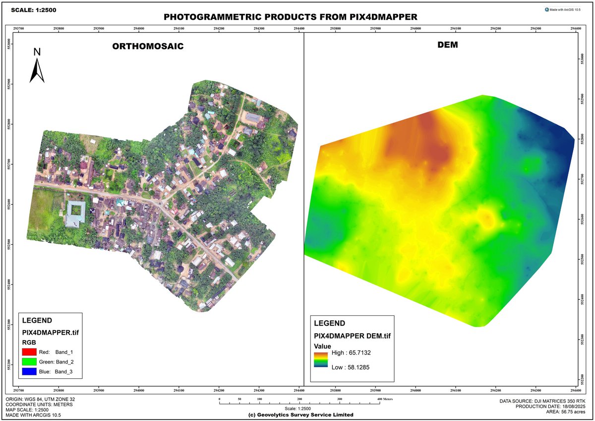
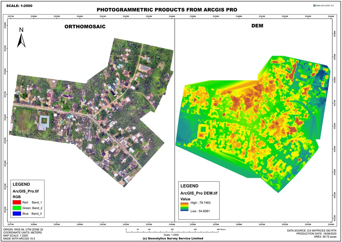
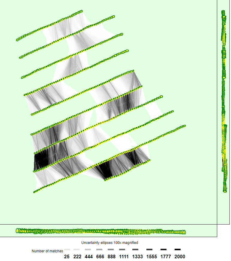
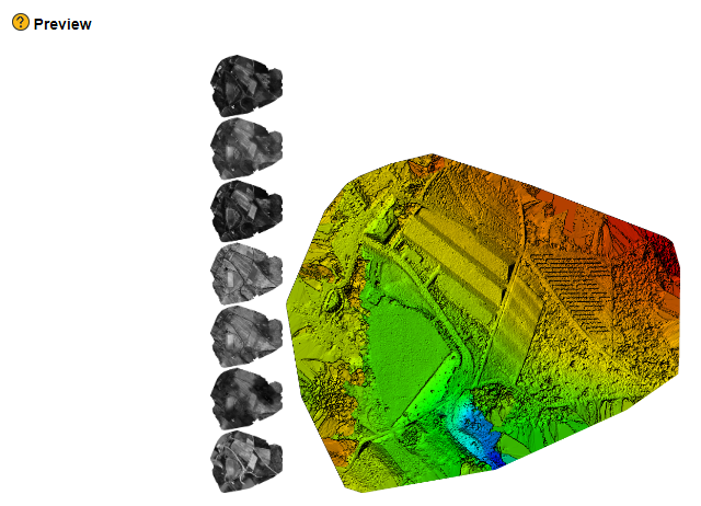
𝙄𝙣𝙩𝙚𝙜𝙧𝙖𝙩𝙚𝙙 𝘿𝙧𝙤𝙣𝙚 𝙈𝙖𝙥𝙥𝙞𝙣𝙜 𝙛𝙤𝙧 𝙎𝙚𝙩𝙩𝙡𝙚𝙢𝙚𝙣𝙩, 𝘼𝙜𝙧𝙞𝙘𝙪𝙡𝙩𝙪𝙧𝙖𝙡 𝙇𝙖𝙣𝙙, 𝙖𝙣𝙙 𝙍𝙤𝙖𝙙 𝙄𝙣𝙛𝙧𝙖𝙨𝙩𝙧𝙪𝙘𝙩𝙪𝙧𝙚 Processed the same dataset using #pix4dmapper #Agisoft Metashape, and #ArcGISPro For more details facebook.com/share/p/1B5pi6…

Pix4Dmatic es un software de mapeo diseñado y optimizado para resolver los desafíos del procesamiento de grandes proyectos ya que puede procesar miles de imágenes manteniendo una precisión topográfica #Pix4D #Pix4DMapper #Pix4Dmatic #Pix4Dsurvey #Software #Fotogrametria #Mapeo


Advanced Drone Solutions BC is a proud partner with Pix4D. We help companies integrate software and drones into their work flow, Reach out to us to find out how we can help you save upto 15% when getting your company transitioned to Drone Data Collection. #pix4d #pix4dmapper #dji


Turn drone imagery into accurate 3D models, orthomosaics, and digital surface models with #Pix4Dmapper. It’s the perfect solution for surveyors needing precision and speed in their aerial data. [email protected] #DroneMapping #SurveyDronesIreland #3DMapping #AerialData

#PIXDmapper Essentials Online workshop 🗺️ Join our workshop and familiarize yourself with #PIX4Dmapper and #PIX4DcloudAdvanced. Learn how to produce 2D and 3D models with a series of hands-on exercises, and streamline your workflow! Sign up here: hubs.li/Q02jQD4c0

Save the date 🗓️ Our next PIX4Dmapper Essentials online workshop takes place July 23-25! 💰 You have until June 25th to save 130 USD with EARLYBIRD-2 coupon code! 💰 Register now: hubs.li/Q02yPYr00 #PIX4Dmapper #PIX4Dcloud #Pix4D

Last chance for early bird pricing! Save 100 USD with the EARLYBIRD coupon code, valid until Aug 29! Register now to attend the #PIX4Dmapper Essentials online workshop. Sept 26-28 9am-2pm, (MDT) hubs.li/Q01_M6Hf0

#PIX4Dmatic 1.64.0 #PIX4Dmapper 4.9 #PIX4Dcloud #PIX4Dfields 2.7 #PIX4Dreact 1.5.1 #PIX4Dsurvey 1.64.0 #PIX4DcapturePro 1.4.0 #PIX4Dcatch #SurveyDronesIreland

Starting August 1st, there will be a change in the basemap provider across several #Pix4D applications: #PIX4Dmapper (v4.10 and above) #PIX4Dfields (v2.9.6 and above) #PIX4Dreact (v1.6 and above) #SurveyDronesIreland

𝙄𝙣𝙩𝙚𝙜𝙧𝙖𝙩𝙚𝙙 𝘿𝙧𝙤𝙣𝙚 𝙈𝙖𝙥𝙥𝙞𝙣𝙜 𝙛𝙤𝙧 𝙎𝙚𝙩𝙩𝙡𝙚𝙢𝙚𝙣𝙩, 𝘼𝙜𝙧𝙞𝙘𝙪𝙡𝙩𝙪𝙧𝙖𝙡 𝙇𝙖𝙣𝙙, 𝙖𝙣𝙙 𝙍𝙤𝙖𝙙 𝙄𝙣𝙛𝙧𝙖𝙨𝙩𝙧𝙪𝙘𝙩𝙪𝙧𝙚 Processed the same dataset using #pix4dmapper #Agisoft Metashape, and #ArcGISPro For more details facebook.com/share/p/1B5pi6…
From high-accuracy 3D mapping to rapid site assessment and agricultural insights, #PIX4D software is transforming how professionals collect, process, and analyse data. [email protected] #SurveyDronesIreland #Pix4Dmapper #Pix4Dfields #Pix4Dcatch

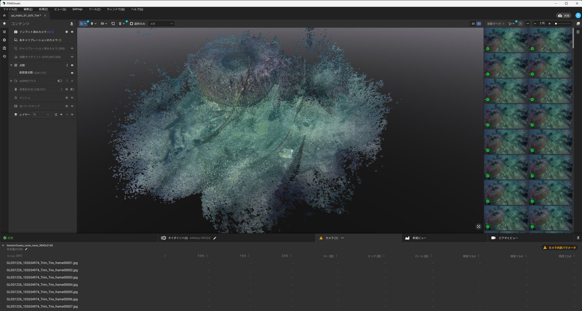
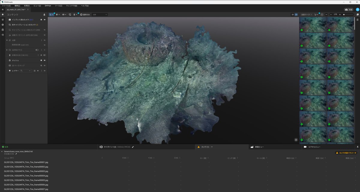
PIX4Dmatic v1.80.0 から「EXIF無画像が取り込める」ようになったので、さっそく「動画から切り出した画像」で試してみました。 2年半前に水中ドローンの体験をさせていただいた時の動画から切り出した画像で、水中にあったタイヤが点群とメッシュになってます。 #PIX4Dmatic #PIX4Dmapper #世代交代
Starting August 1st, there will be a change in the basemap provider across several #Pix4D applications: #PIX4Dmapper (v4.10 and above) #PIX4Dfields (v2.9.6 and above) #PIX4Dreact (v1.6 and above) #SurveyDronesIreland
Transform aerial imagery into accurate 2D maps and 3D models with #Pix4Dmapper Licence Pricing: ✅ Monthly Licence – €290 ✅ Yearly Licence – €1,450 ✅ Perpetual Licence – €3,500 [email protected] #DroneSurveying #ConstructionTech #SurveyDronesIreland
Accurate, reliable mapping starts with the right software — and #Pix4Dmapper continues to set the standard for drone-based photogrammetry. [email protected] #DroneMapping #AerialSurveying #SurveyDronesIreland #PhotogrammetryTraining #MappingSoftware
When it comes to transforming aerial images into highly accurate 2D maps and 3D models, PIX4Dmapper is the go-to solution for surveyors, engineers, and GIS professionals. #SurveyDronesIreland #PIX4Dmapper #DroneMapping #Photogrammetry #SurveyingSoftware #GIS #3DMapping
Turn drone imagery into accurate 3D models, orthomosaics, and digital surface models with #Pix4Dmapper. It’s the perfect solution for surveyors needing precision and speed in their aerial data. [email protected] #DroneMapping #SurveyDronesIreland #3DMapping #AerialData
Transform your aerial imagery into stunning 3D landscapes and ultra-detailed maps with #Pix4DMapper – your go-to solution for professional drone mapping! #SurveyDronesIreland #DJI #multispectral #drones #agriculture #mapping #landsurveying #droneIreland

Nuevo ATygeo Thermal para cámaras DJI Zenmuse H30T. Crea ortomosaicos térmicos radiométricos de una manera simple y sencilla. New version of ATygeo Thermal for #ZenmuseH30T is now available. Create radiometric orthomosaics in a simple way. #pix4dmapper @pix4d @DJIEnterprise
Advanced Drone Solutions BC is a proud partner with Pix4D. We help companies integrate software and drones into their work flow, Reach out to us to find out how we can help you save upto 15% when getting your company transitioned to Drone Data Collection. #pix4d #pix4dmapper #dji
Whether you're in surveying, construction, or agriculture, #Pix4DMapper turns your aerial imagery into valuable data. Monthly: €290.00 Yearly: €2,900.00 Perpetual: €4,690.00 #SurveyDronesIreland #DJIEnterprise #Pix4D
#PIX4Dmatic 1.64.0 #PIX4Dmapper 4.9 #PIX4Dcloud #PIX4Dfields 2.7 #PIX4Dreact 1.5.1 #PIX4Dsurvey 1.64.0 #PIX4DcapturePro 1.4.0 #PIX4Dcatch #SurveyDronesIreland
Transform your aerial data into actionable insights with industry-leading photogrammetry software. Whether you're in surveying, construction, or agriculture, #Pix4D has the tools you need. [email protected] #Pix4DCapture #Pix4DMapper #Pix4DSurvey #CAD #Pix4DCatch
Looking for the ultimate software to transform your drone data into stunning deliverables? #Pix4DMapper has got you covered! Invest smart, fly smarter! [email protected] #SurveyDronesIreland #DJI #multispectral #drones #agriculture #mapping #landsurveying #droneIreland

Ankylosaur trackways captured in a digital outcrop model by William Hawkins. A digital snapshot for outcrop preservation and a great way for more people to see these amazing features. Model created in #PIX4DMapper and interpreted in #VRGS. linkedin.com/posts/williamb…

📝 Sign up now! #PIX4Dmatic and #PIX4Dmapper Essentials online workshop, August 6-8 ✨ 💵 You have until July 9 to save 130 USD with EARLYBIRD-2 coupon code! 💵 Enroll here: hubs.li/Q02zPSjs0

昨日に続き、6/6(木) 11:30~ JapanDrone展のPix4D社様ブースにて、ミニ講演をさせていただきます。 時代は「PIX4Dmapper」から「PIX4Dmatic」への世代交代のフェーズに入っています。某有名マンガの世代交代に例えて楽しく紹介するつもりです。 #JapanDrone展 #PIX4Dmatic #PIX4Dmapper #世代交代
Elevate your projects with #Pix4Dmapper, the leading photogrammetry software for professional #dronemapping! Monthly Licence. – €290.00 Yearly Licence. – €2,900.00 Perpetual Licence. – €4690.00 #SurveyDronesIreland #DJI
Save the date 🗓️ Our next PIX4Dmapper Essentials online workshop takes place July 23-25! 💰 You have until June 25th to save 130 USD with EARLYBIRD-2 coupon code! 💰 Register now: hubs.li/Q02yPYr00 #PIX4Dmapper #PIX4Dcloud #Pix4D

Advanced Drone Solutions BC is a proud partner with Pix4D. We help companies integrate software and drones into their work flow, Reach out to us to find out how we can help you save upto 15% when getting your company transitioned to Drone Data Collection. #pix4d #pix4dmapper #dji
Looking for the ultimate software to transform your drone data into stunning deliverables? #Pix4DMapper has got you covered! Invest smart, fly smarter! [email protected] #SurveyDronesIreland #DJI #multispectral #drones #agriculture #mapping #landsurveying #droneIreland
Dive into the world of #PIX4Dmapper! Join our course to master critical workflows for creating 2D & 3D representations of reality. 📷 Learn best practices, hands-on techniques, & more! Save $100 with code EARLYBIRD-1 valid until Oct 31. 🗓️ Register here: hubs.li/Q023H3G30

Whether you're in surveying, construction, or agriculture, #Pix4DMapper turns your aerial imagery into valuable data. Monthly: €290.00 Yearly: €2,900.00 Perpetual: €4,690.00 #SurveyDronesIreland #DJIEnterprise #Pix4D
When it comes to transforming aerial images into highly accurate 2D maps and 3D models, PIX4Dmapper is the go-to solution for surveyors, engineers, and GIS professionals. #SurveyDronesIreland #PIX4Dmapper #DroneMapping #Photogrammetry #SurveyingSoftware #GIS #3DMapping
Studio Calastri overcame mapping challenges with #Pix4D. The project was originally done in #PIX4Dmapper and then reprocessed in #PIX4Dmatic, saving time, and improving the quality of the results! read more here: hubs.li/Q025WZtL0

Transform aerial imagery into accurate 2D maps and 3D models with #Pix4Dmapper Licence Pricing: ✅ Monthly Licence – €290 ✅ Yearly Licence – €1,450 ✅ Perpetual Licence – €3,500 [email protected] #DroneSurveying #ConstructionTech #SurveyDronesIreland
Elevate your projects with #Pix4Dmapper, the leading photogrammetry software for professional #dronemapping! Monthly Licence. – €290.00 Yearly Licence. – €2,900.00 Perpetual Licence. – €4690.00 #SurveyDronesIreland #DJI
From high-accuracy 3D mapping to rapid site assessment and agricultural insights, #PIX4D software is transforming how professionals collect, process, and analyse data. [email protected] #SurveyDronesIreland #Pix4Dmapper #Pix4Dfields #Pix4Dcatch
🎉 We are thrilled to welcome Horacio Valencia from APD as our new Certified Trainer for #PIX4Dmapper! Congratulations to Horacio for this achievement! 🎓👏 Interested in becoming a Certified Trainer, click here for more information: hubs.li/Q02gLjlF0

Starting August 1st, there will be a change in the basemap provider across several #Pix4D applications: #PIX4Dmapper (v4.10 and above) #PIX4Dfields (v2.9.6 and above) #PIX4Dreact (v1.6 and above) #SurveyDronesIreland
Empower your drone mapping and photogrammetry projects with the industry-leading #Pix4D software, available through our team at #SurveyDronesIreland. #pix4Dmapper #pix4cloud #3dmapping #dronemapping #photogrammetry #Irelanddrone #dronesurveying #3D #pix4dcapture

Accurate, reliable mapping starts with the right software — and #Pix4Dmapper continues to set the standard for drone-based photogrammetry. [email protected] #DroneMapping #AerialSurveying #SurveyDronesIreland #PhotogrammetryTraining #MappingSoftware

PIX4D社 比類のないモバイルおよびドローンマッピング向け フォトグラメトリーソフトウェア群と データキャプチャハードウェア「viDoc RTK rover」 kobeseiko.co.jp/pix4d.html #PIX4Dmapper #PIX4Dmatic #PIX4Dcloud #viDocRTKrover #iphoneLiDAR #iPadProLiDAR #LiDAR

Transform your aerial data into actionable insights with industry-leading photogrammetry software. Whether you're in surveying, construction, or agriculture, #Pix4D has the tools you need. [email protected] #Pix4DCapture #Pix4DMapper #Pix4DSurvey #CAD #Pix4DCatch
Using #Pix4DMapper the photogrammetry algorithms simply transform your ground or areal images in digital maps and 3D models. surveydrones.ie/pix4dsoftware/… [email protected] #SurveyDronesIrealdn #Pix4D #DJIEnterprise #DroneIreland #Mapping

Pix4Dmatic es un software de mapeo diseñado y optimizado para resolver los desafíos del procesamiento de grandes proyectos ya que puede procesar miles de imágenes manteniendo una precisión topográfica #Pix4D #Pix4DMapper #Pix4Dmatic #Pix4Dsurvey #Software #Fotogrametria #Mapeo
One of the most fascinating things about #Pix4DMapper is its ability to create multispectral image combinations like NDVI and NDWI. Ready to take your surveying game to the next level? Check out Pix4D Mapper at #SurveyDronesIreland #DJI #multispectral #drone #droneIreland
Something went wrong.
Something went wrong.
United States Trends
- 1. #UFC327 N/A
- 2. Jiri N/A
- 3. Ulberg N/A
- 4. Hokit N/A
- 5. #TAEMCHELLA N/A
- 6. Paulo Costa N/A
- 7. Cub Swanson N/A
- 8. Derrick Lewis N/A
- 9. Nine Inch Noize N/A
- 10. #TNARebellion N/A
- 11. #OPLive N/A
- 12. #pinkchella N/A
- 13. Reyes N/A
- 14. Gable Steveson N/A
- 15. Dana White N/A
- 16. Murzakanov N/A
- 17. NO DEAL N/A
- 18. La Catalina N/A
- 19. KO'd N/A
- 20. Tyriq Withers N/A