#satellitedata search results

From GNSS jamming and undersea cable sabotage to illegal migration networks and clandestine military movements - DataWalk helps government, defense, and security organizations. datawalk.com/identifying-em… #SatelliteData #NationalSecurity #DataFusion #IntelligenceAnalysis


📡 #Satellitedata is now accessible to all businesses and offers incredible opportunities. From managing infrastructure risk to improving sustainability. Learn more about the power of #EOdata and seize the opportunity for your business. tinyurl.com/ycyjs48d


📡Final move. The satellite dish is in place — the Data Acquisition Station is coming to life. Stay tuned #EarthObservation #SatelliteData #Cyprus #ERATOSTHENESCoE @CyUniTechof @DLR_en @beyond_center

Ya pensó en desarrollar actividades de investigación durante la carrera universitaria? 🤔💭 Tienes interés de trabajar en áreas #EarthObservations #EarthSciences #SatelliteData #MachineLearning #DeepLearning #RemoteSensing #GIS #Mapping? Ven y colabora con nosotros… abro 🧵1/6


🌍📊 WorldPop's cutting-edge research showcased at #JSM2025 #SatelliteData to improve #population estimates - esp. where data is scarce. 📡 >40% less bias. 📍 Smarter models. 🚀 Better decisions for health, aid & planning. #Statistics #DataForGood worldpop.org/blog/worldpop-…

SpaceChain's Decentralized Satellite Applications Platform simplifies #SatelliteData access & analysis. Discover why #DSA is the optimal interface for acquiring satellite data here: tinyurl.com/59y7px5m Revolutionizing the Space Economy. spacechain.com

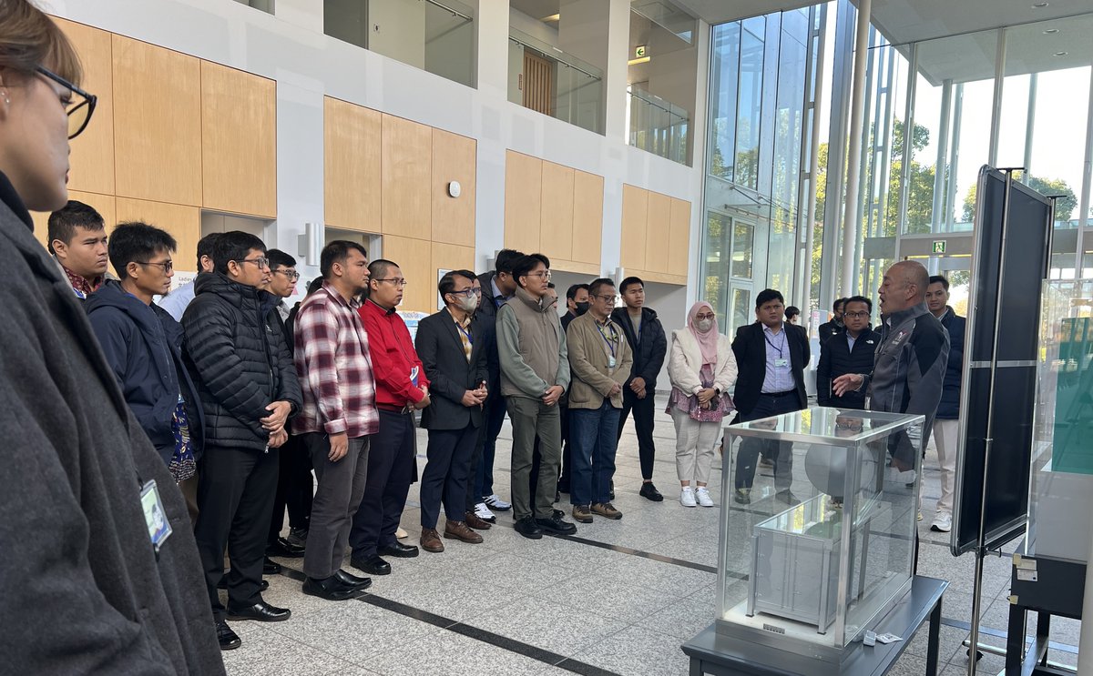
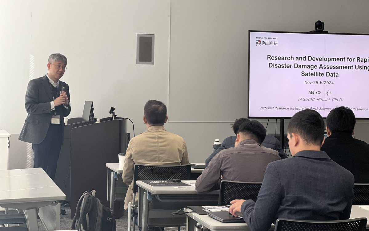
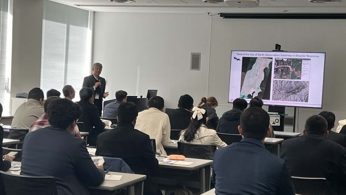
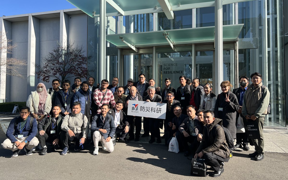
As part of a capacity building training program learning Japan's EEW system, organized by ADRC, the Indonesian @infoBMKG officials visited #NIED on Nov 25 and received a lecture from NIED’s Dr. Hitoshi Taguchi on early disaster damage assessment using #SatelliteData.

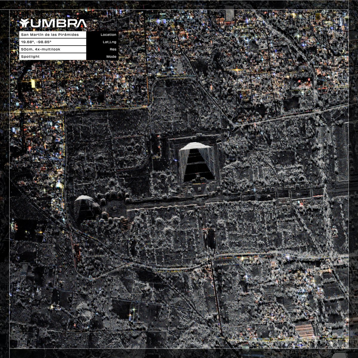
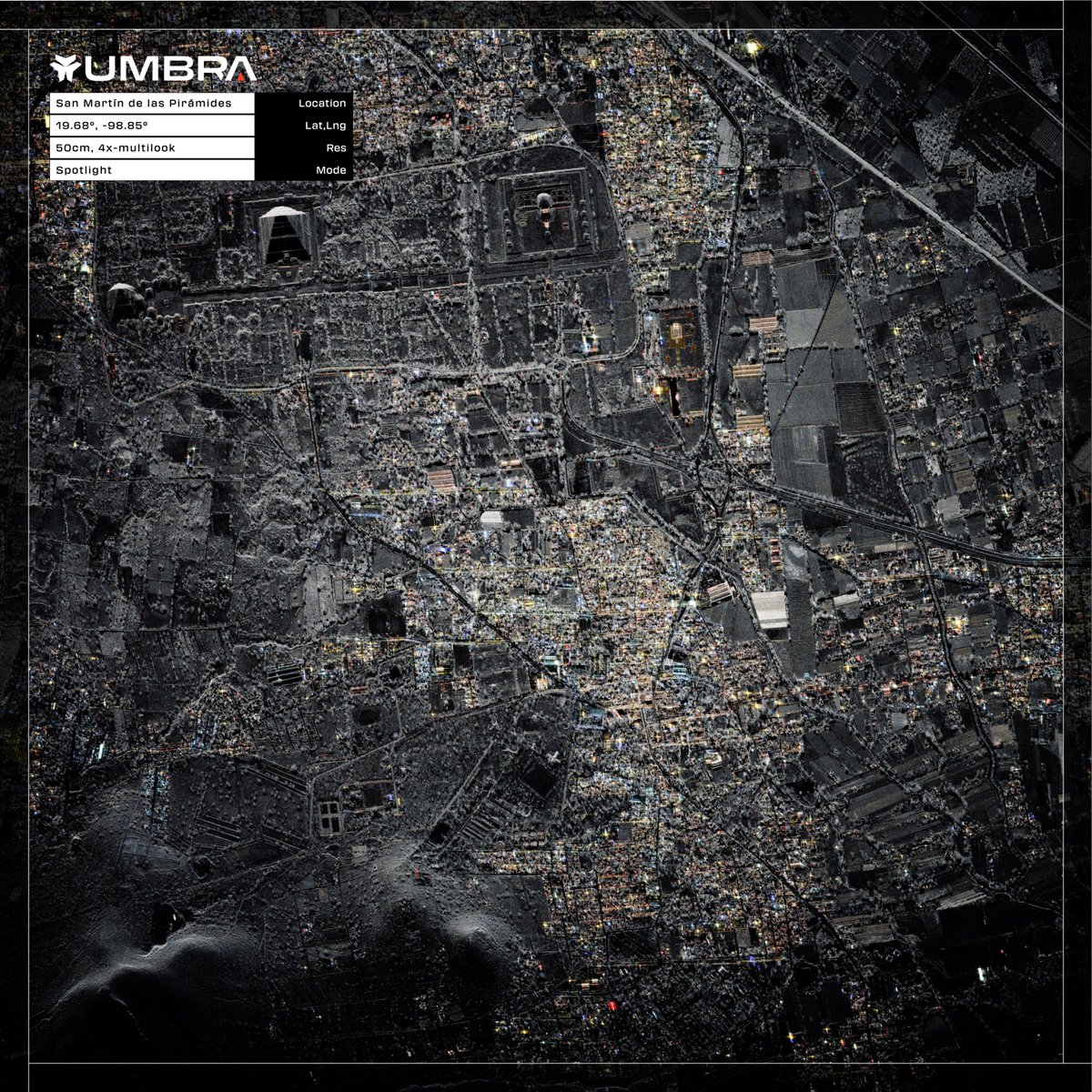
San Martín de las Pirámides, Mexico | 50cm | 4x-Multilook Now available to download from the Umbra Open Data Program. #SatelliteData #Mexico
📡 With very low barriers to entry, I-Sat democratizes access to satellite applications so that anyone seeking #satellitedata or applications can use the platform without prior expertise. 💡 Learn more here: tinyurl.com/yn6bytyk #SpaceChain #EO #AI #ISAT


Satellites + AI = real-time greenhouse gas tracking 🌿Organizations like Climate TRACE & GHGSat are enabling transparency & smarter climate action. Discover how space tech fights emissions! geoawesome.com/eo-hub/how-org… #SatelliteData #GHG #EarthObservation #Climate #Geoawesome
Did you know? Satellite data is changing the way people trade goods because it gives them real-time information about oil storage, crops, and supply chains. Learn more in our Geoawesome article: geoawesome.com/eo-hub/how-sat… #Geoawesome #SatelliteData #CommodityTrading #RemoteSensing
🚀🌌 Satellite data has evolved since Sputnik 1! With huge volumes of data now available, how do we manage it all? How are platforms making data analysis simpler and more impactful? geoawesome.com/eo-hub/making-… Full video: youtu.be/mbf0IrSmeuY #SatelliteData #Geoawesome

Super excited to share that our latest research on boosting #CropClassification with #SatelliteData is finally out in #RemoteSensingOfEnvironment 🚀🌾 Look into our findings on improving accuracy in agricultural monitoring ⏩ sciencedirect.com/science/articl…


HotSat-2 and HotSat-3 are set to launch in 2025, bringing with them even more exciting high-resolution #thermalimagery. 🛰️ Alongside our new partners, we're taking #EarthObservation to the next level. More on this step forward 🔗 satellitevu.pulse.ly/4amfajp0vi #SatelliteData
2021 saw 432 natural disasters, with floods leading the way. How can satellite data help us tackle these challenges? Learn more in Geoawesome’s article!🌍 Read it here: shorturl.at/ocjls Full video: youtu.be/JnICrXKoTWI #Flooding #SatelliteData #Climate #Geoawesome

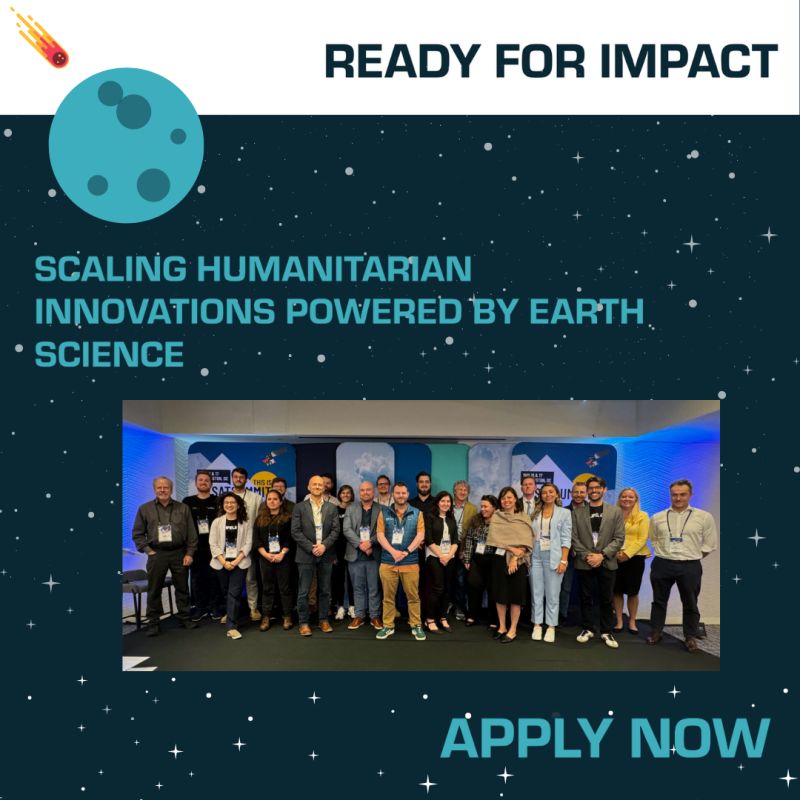
🌍 Are you a humanitarian or scientist ready to scale your satellite data-powered innovations? ✨ Expert guidance 🤝 Humanitarian partnerships 💡 Pitch training & stipend 📅 Apply by Jan 21, 2025: wp.me/p23f03-cq5 #ReadyForImpact #SatelliteData #InnovationForGood
The EROS Center is home to the world’s largest civilian collection of #SatelliteData and #AerialImagery, data products, and more. May this #HolidaySeason and the new year bring you opportunities to explore the world, whether through the EROS archive or your own adventures.

Are you heading to #SpaceCommExpoScotland tomorrow? Interested in learning how #SatelliteData insights can help you make informed decisions about risk, opportunity, and compliance for your business? 📩 DM us to arrange to meet with @fortiain to learn more.

✨Geoawesome Fact ✨Satellites like Sentinel-1 can detect sea surface changes from undersea earthquakes? Learn how satellite tech is making coasts safer in our full article: shorturl.at/t0r44 Full video on YT: youtu.be/rkAegn0gBtA #Tsunami #SatelliteData #Geoawesome

UConn Researchers Work to Enhance Forest Carbon Monitoring @UConn #satellitedata #earthobservation #forest #abovegroundbiomass today.uconn.edu/2025/10/uconn-…

Record-breaking 2024 Amazon fires drive unprecedented carbon emissions and ecosystem degradation #satellitedata #earthobservation #wildfires #carbonemissions egu.eu/news/1509/reco…

Satellite program aims to track every wildfire on Earth #satellitedata #earthobservation #wildfires yaleclimateconnections.org/2025/10/satell…

Introducing Owl: Planet's Most Advanced Satellite Mission Yet @planet #satellitedata #earthobservation #multispectral #edgecomputing planet.com/pulse/introduc…


LinkGevity Secures UK Space Agency Funding to Revolutionize Satellite Data Usage for Anti-necrotic Therapeutic: On October 8, 2025, the UK Space Agency announced a… dlvr.it/TNb7mF #SpaceInnovation #Biotechnology #SatelliteData #HealthcareRevolution #AgeRelatedDecline

The Future of Antarctic Ice: New Study Reveals the Mathematics of Meltwater Lakes @GeorgiaTech #satellitedata #earthobservation #antarcticice #climatemodels research.gatech.edu/future-antarct…

Satellites reveal the power of ocean swell @esa #satellitedata #earthobservation #oceanswell #oceanscience esa.int/Applications/O…

Abandoned land drives dangerous heat in Houston, Texas A&M study finds @TAMU #satellitedata #earthobservation #urbanheat #urbanplanning stories.tamu.edu/news/2025/10/0…
Stirling to play key role in UK Space Agency funded water quality monitoring project @StirUni #satellitedata #earthobservation #waterquality stir.ac.uk/news/2025/octo…

Predicting and managing harmful algal blooms @UniofExeter #satellitedata #earthobservation #harmfulalgalbloom news.exeter.ac.uk/centre-for-res…


BRICS welcomes Iran’s proposal for establishing joint satellite data platform #BRICS #Iran #SatelliteData #SpaceCollaboration #BRICSSummit #GlobalSouth #SpaceTechnology #InternationalCooperation #EmergingPowers #Geopolitics


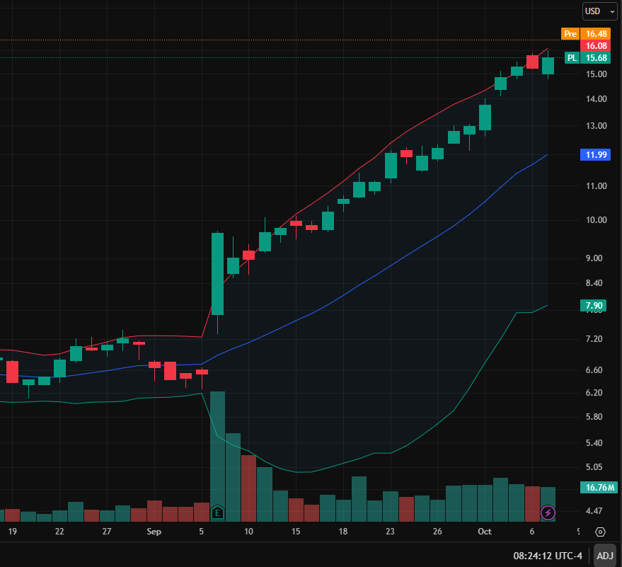
Stock to Watch: $PL🚀 Upside: 50% World's top sat imagery firm, surging on EO data demand Next annual revenue projected at $3.39B, up 18.7% Next quarterly earnings on November 11th Worthy of long-term attention #EarthObservation #SatelliteData


पंजाब में सेटेलाइट डेटा से पराली जलाने की घटनाओं की संख्या PPCB के आधिकारिक आंकड़ों से कहीं ज़्यादा पाई गई है —। 🔗 gaonjunction.com/khabar-junctio… #ParaliBurning #PunjabPollution #SatelliteData #AirQuality #Environment #PPCB #Agriculture #ClimateAction #स्वच्छहवा #पर्यावरणसंरक्षण

Millions of buildings at risk from sea level rise, McGill-led study finds @mcgillu #satellitedata #earthobservation #sealevelrise mcgill.ca/newsroom/chann…
mcgill.ca
Millions of buildings at risk from sea level rise, McGill-led study
Sea level rise could put more than 100 million buildings across the Global South at risk of regular flooding if fossil fuel emissions are not curbed quickly, according to a new McGill-led study
Satellite Scans Can Estimate Urban Emissions #satellitedata #earthobservation #greenhousegas #urbanemissions eos.org/research-spotl…


Unlock the future of decision-making with Zaitra's groundbreaking satellite insights! 🚀 #InnovationInTech #SatelliteData biz-index.net/blogs/founder-…


🚀 Transform your biz with Zaitra's satellite data insights! Instant alerts that boost efficiency across sectors. #InnovationInTech #SatelliteData biz-index.net/blogs/founder-…

Preserving Earth’s wetlands with satellite technology @InsideNatGeo #satellitedata #earthobservation #wetlands #biodiversity news.nationalgeographic.org/lola-fatoyinbo…

Scientists rethink Serengeti migration numbers with satellite, AI tools #satellitedata #earthobservation #artificialintelligence #wildebeest news.mongabay.com/2025/10/scient…

Unlocking Multi-Spectral Data with Gemini @googledevs #satellitedata #earthobservation #artificialintelligence developers.googleblog.com/en/unlocking-m…


📡 #Satellitedata is now accessible to all businesses and offers incredible opportunities. From managing infrastructure risk to improving sustainability. Learn more about the power of #EOdata and seize the opportunity for your business. tinyurl.com/ycyjs48d
San Martín de las Pirámides, Mexico | 50cm | 4x-Multilook Now available to download from the Umbra Open Data Program. #SatelliteData #Mexico
Ya pensó en desarrollar actividades de investigación durante la carrera universitaria? 🤔💭 Tienes interés de trabajar en áreas #EarthObservations #EarthSciences #SatelliteData #MachineLearning #DeepLearning #RemoteSensing #GIS #Mapping? Ven y colabora con nosotros… abro 🧵1/6
🌍 Are you a humanitarian or scientist ready to scale your satellite data-powered innovations? ✨ Expert guidance 🤝 Humanitarian partnerships 💡 Pitch training & stipend 📅 Apply by Jan 21, 2025: wp.me/p23f03-cq5 #ReadyForImpact #SatelliteData #InnovationForGood
SpaceChain's Decentralized Satellite Applications Platform simplifies #SatelliteData access & analysis. Discover why #DSA is the optimal interface for acquiring satellite data here: tinyurl.com/59y7px5m Revolutionizing the Space Economy. spacechain.com

Scientists from the University of Washington and Bangladesh's Ministry of Agriculture are using NASA satellite data to help Bangladeshi farmers save water with the IRAS irrigation system #satellitedata #climatechange #innovation #watersaving #globalagriculture @NASA

📡 With very low barriers to entry, I-Sat democratizes access to satellite applications so that anyone seeking #satellitedata or applications can use the platform without prior expertise. 💡 Learn more here: tinyurl.com/yn6bytyk #SpaceChain #EO #AI #ISAT

Despite growing interest in commercial #satellite data, industry faces uncertainty - buff.ly/43Knoq1 #space #satellitedata #satelliteimagery
As part of a capacity building training program learning Japan's EEW system, organized by ADRC, the Indonesian @infoBMKG officials visited #NIED on Nov 25 and received a lecture from NIED’s Dr. Hitoshi Taguchi on early disaster damage assessment using #SatelliteData.
🛰️ Get ready to access & analyze #SatelliteData with ease! #SpaceChain's Decentralized Satellite Applications Platform makes it simple. Learn why #DSA is the best interface for acquiring satellite data in our video. bit.ly/418W5V3 #DecentralizedTechnology #Blockc ...


🚀 Private leaderboard for Aerosol Optical Depth Estimation competition is open! 👇 Check out the final standings & make late subs. Publish your solution write-ups and other topics too! solafune.com/competitions/c… #Solafune #Competition #SatelliteData #MachineLearning #DataScience


The 74th @Iac2023 in Baku is underway. Swing by our booth #515 and chat about #GroundStation services, future #SubOrbitalExpress missions, #SatelliteData analytics and #SatLaunch – all part of our offering 🚀🛰️📡 @iafastro #IAC2023 #SmallSatExpress #Orbital #SSCconnect #SatCom

2,500 acres of high alpine adventure anyone? Copper Mountain, Colorado, USA | 35cm Resolution Now available to download from the Umbra Open Data Program. #sar #satellitedata #satelliteimagery #colorado


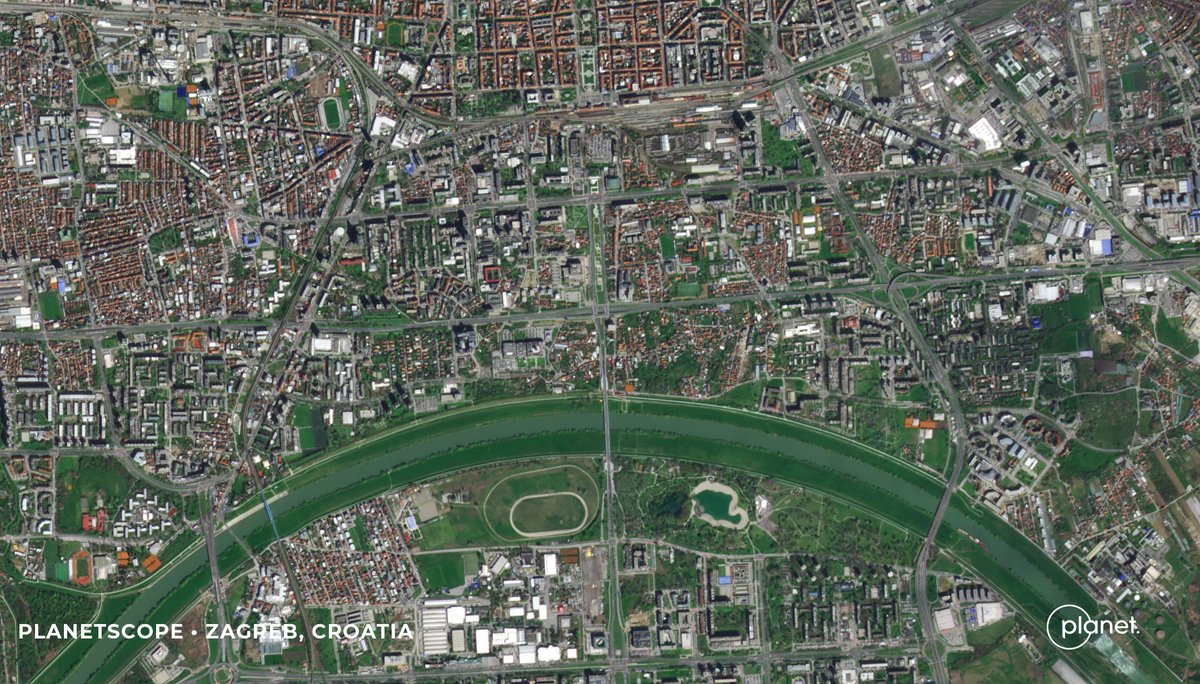
Can satellites cure allergies?🤧 Maybe not. But researchers from the University of Zagreb and @suminsCFRI used @Planet #satellitedata + #ML techniques to map & identify allergenic tree species Zagreb, Croatia for better informed city planning. Read on: go.planet.com/allergies
Using advanced #AI computer vision models, @Royce_Geo leveraged @Planet #satellitedata to identify & track “dark” vessels & uncover Russia’s illicit oil supply route. Learn how: go.planet.com/roycegeo


📡 Throwback to Q2 FY2024: 725 spacecraft launched, with 84% dedicated to communications. Learn more: brycetech.com/briefing #BryceBriefing #SatelliteData #SpaceIndustry


Decades of Satellite Data Unveil Alarming Sea Level Rise Trends 🛰️ 🌊 Long-term records reveal a doubling in the rate of sea level rise since 1993, driven by global warming and exacerbated by El Niño events. More 👉 bit.ly/GRSS-eNewslett… #SatelliteData #ClimateTrends

Welcome to @GEOBusinessShow! Don't forget to join us & our experts 12.30, Earth Insights stage, to demystify satellite climate data services - EO for GEO! @OrdnanceSurvey @4_intelligence @GeoByENVI #Agtelligence #EarthObservation #SatelliteData #ClimateAction #GEOBusiness


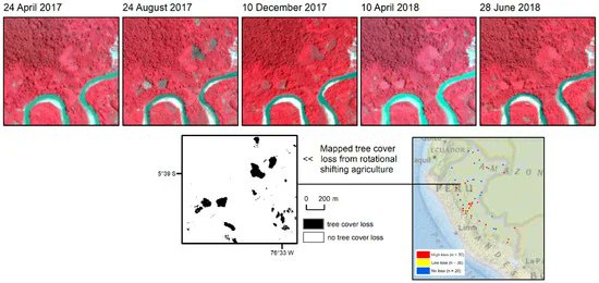
Using #MultiResolution #SatelliteData to Quantify Land Dynamics: Applications of #PlanetScope Imagery for #Cropland and Tree-Cover Loss Area Estimation by Jeffrey Pickering, Alexandra Tyukavina, Ahmad Khan, Peter Potapov, et all. @UofMaryland 👉mdpi.com/2072-4292/13/1
We are excited to announce the 2023 HAQAST Teams have been selected! We are looking forward to the launch of these teams, using #SatelliteData to support a wide range of #health, #AirQuality, and #EnvironmentalJustice topics!

Something went wrong.
Something went wrong.
United States Trends
- 1. Chiefs 103K posts
- 2. Branch 30.6K posts
- 3. Mahomes 31.4K posts
- 4. #TNABoundForGlory 51.6K posts
- 5. #LoveCabin N/A
- 6. LaPorta 10.2K posts
- 7. Goff 13.5K posts
- 8. Bryce Miller 4,279 posts
- 9. #LaGranjaVIP 50.5K posts
- 10. Kelce 16K posts
- 11. #OnePride 6,310 posts
- 12. Dan Campbell 3,509 posts
- 13. Butker 8,386 posts
- 14. #DETvsKC 4,863 posts
- 15. Mariners 48.7K posts
- 16. Rod Wave N/A
- 17. Gibbs 5,515 posts
- 18. Pacheco 4,936 posts
- 19. Baker 54.3K posts
- 20. Collinsworth 2,953 posts