#digitalelevationmodel search results

3D Model of Highest Steep Face in the Alps #remotesensing #digitalelevationmodel #glacier #climatechange uni-heidelberg.de/en/newsroom/3d…

Using Satellites and Supercomputers to Track Arctic Volcanoes #SatelliteData #DigitalElevationModel eos.org/articles/using…


#NOAA #DigitalElevationModel #Topography #Bathymetry #CoastalChange #HurricaneMichael #CapeSanBlas #Florida


The wide area #digitalelevationmodel revolution blog.digitalglobe.com/2016/11/07/the… bit.ly/2ei1YMg


Get #digitalelevationmodel data where you need it - anywhere in the globe. #GIS #DEM ow.ly/9gWZ303tsep


The New #Landsat Collection-2 #DigitalElevationModel by Shannon Franks, James Storey and Rajagopalan Rengarajan 👉mdpi.com/2072-4292/12/2… #remotesensing

I’m really liking this #DigitalElevationModel produced using #LiDAR #data we collected from one of our #UAV flights for #stockpile inventory

The Richat Structure, also known as the Eye of the Sahara and Guelb er Richat in World DEM #DigitalElevationModel #GIS #Sahara #Imagery

And the georectified overlay on the #TanDEM-X #DigitalElevationModel - thanks to Kevin White for georectifying this part of the #Quickbird #satellite image years ago #MinaretofJam #Afghanistan #archaeology

#mostcited 📢A Global-Information-Constrained #DeepLearning Network for #DigitalElevationModel Super-Resolution by Xiaoyi Han, Xiaochuan Ma, Houpu Li and Zhanlong Chen doi.org/10.3390/rs1502… #ImageProcessing


This #HighRes #DigitalElevationModel product is derived from airborne #LiDAR data and #satellite imagery. Learn more: ow.ly/Go6S50JKYIm #Maritimes


Exploit the benefits of #DigitalElevationModel through #SentinelHub. More in our latest blog: sentinel-hub.com/blog/digital-e… #DEM #EarthObservation
Get #digitalelevationmodel data where you need it - anywhere in the globe. #GIS #DEM... bit.ly/2c0o85c

👉👉 A Global-Information-Constrained #DeepLearning Network for #DigitalElevationModel Super-Resolution ✍️ Xiaoyi Han et al. 🔗 mdpi.com/2072-4292/15/2…


Check out this #DigitalElevationModel... it represents a merger between #airborneLiDAR collected at over 70points per square meter and multi-beam #hydrographic data. #LiDAR #Mapping


Beach #Erosion occurs when dune ridges are formed as sediment from rivers and coastlines accumulates and moves by the ocean, a scene familiar to property owners in the Southeast. Our #DigitalElevationModel (DEM) of Ossabaw Island, GA shows how the island has changed over time.


Global #DigitalElevationModel Comparison Criteria: An Evident Need to Consider Their Application By Carlos López-Vázquez and Francisco Javier Ariza-López 👉mdpi.com/2431344


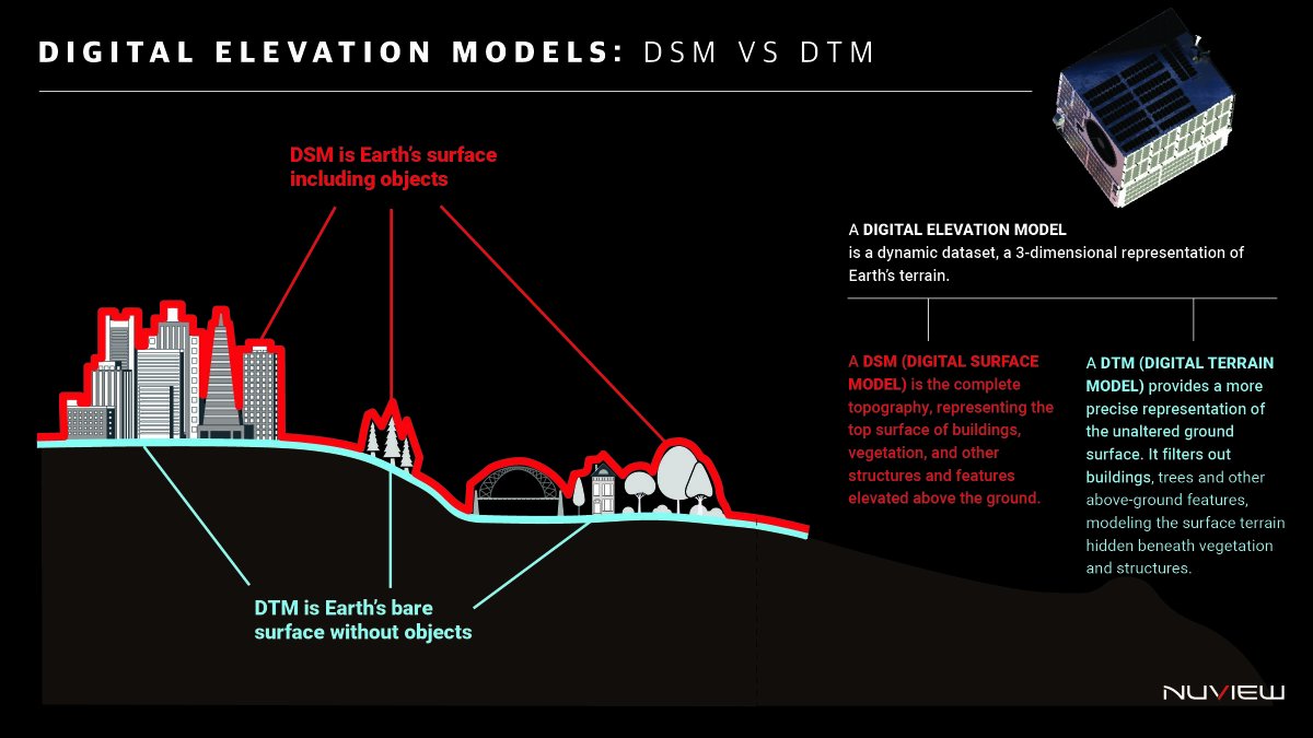
We’re building the most accurate global #DigitalElevationModel that has ever existed because #infrastructure, #climate modeling, and #nationalsecurity all depend on knowing not just where things are, but what lies beneath them. A #DSM gives us the top layer like structures,…
3D Model of Highest Steep Face in the Alps #remotesensing #digitalelevationmodel #glacier #climatechange uni-heidelberg.de/en/newsroom/3d…

Elevate your GIS with advanced LiDAR integration. We offer affordable, high-quality classification and DEMs for bare earth, topography, and land use. For more information, Visit our website:- designpresentation.com/services/forma… #GISMapping #DigitalElevationModel

We’re building the most accurate global #DigitalElevationModel that has ever existed because #infrastructure, #climate modeling, and #nationalsecurity all depend on knowing not just where things are, but what lies beneath them. A #DSM gives us the top layer like structures,…

Where to access DEM data: • USGS EarthExplorer • NASA SRTM Data • Copernicus Open Access Hub Turning terrain into insight starts with understanding elevation. Join us today at sdssn.org #DigitalElevationModel #DEM #Floodmapping #SpatialDataScience #Climate #GIS

Morphometric Analysis of Umtung River Basin using GIS and Remote Sensing Read more here: cwejournal.org/vol1no1/pmorph… #DigitalElevationModel #GIS #Morphometricanalysis #Riverbasin #Remotesensing #environment #wastemanagement #environmentallaws #environmentalchemistry


An On-Site InSAR Terrain Imaging Method with Unmanned Aerial Vehicles mdpi.com/1424-8220/24/7… #InSAR; #unmannedaerialvehicle; #digitalelevationmodel

👉👉 A Global-Information-Constrained #DeepLearning Network for #DigitalElevationModel Super-Resolution ✍️ Xiaoyi Han et al. 🔗 mdpi.com/2072-4292/15/2…
#mostcited 📢A Global-Information-Constrained #DeepLearning Network for #DigitalElevationModel Super-Resolution by Xiaoyi Han, Xiaochuan Ma, Houpu Li and Zhanlong Chen doi.org/10.3390/rs1502… #ImageProcessing
Inflation Reduction Act accelerates USGS effort to collect high-resolution data of landscapes across 25 states #remotesensing #topography #digitalelevationmodel usgs.gov/news/national-…

Global #DigitalElevationModel Comparison Criteria: An Evident Need to Consider Their Application By Carlos López-Vázquez and Francisco Javier Ariza-López 👉mdpi.com/2431344

Semi-automated #classification of #layeredrockslope using #digitalelevationmodel and #geologicalmap (doi.org/10.1515/geo-20…)

#NOAA #DigitalElevationModel #Topography #Bathymetry #CoastalChange #HurricaneMichael #CapeSanBlas #Florida
Using Satellites and Supercomputers to Track Arctic Volcanoes #SatelliteData #DigitalElevationModel eos.org/articles/using…
Get #digitalelevationmodel data where you need it - anywhere in the globe. #GIS #DEM ow.ly/9gWZ303tsep
The wide area #digitalelevationmodel revolution blog.digitalglobe.com/2016/11/07/the… bit.ly/2ei1YMg
3D Model of Highest Steep Face in the Alps #remotesensing #digitalelevationmodel #glacier #climatechange uni-heidelberg.de/en/newsroom/3d…


The New #Landsat Collection-2 #DigitalElevationModel by Shannon Franks, James Storey and Rajagopalan Rengarajan 👉mdpi.com/2072-4292/12/2… #remotesensing


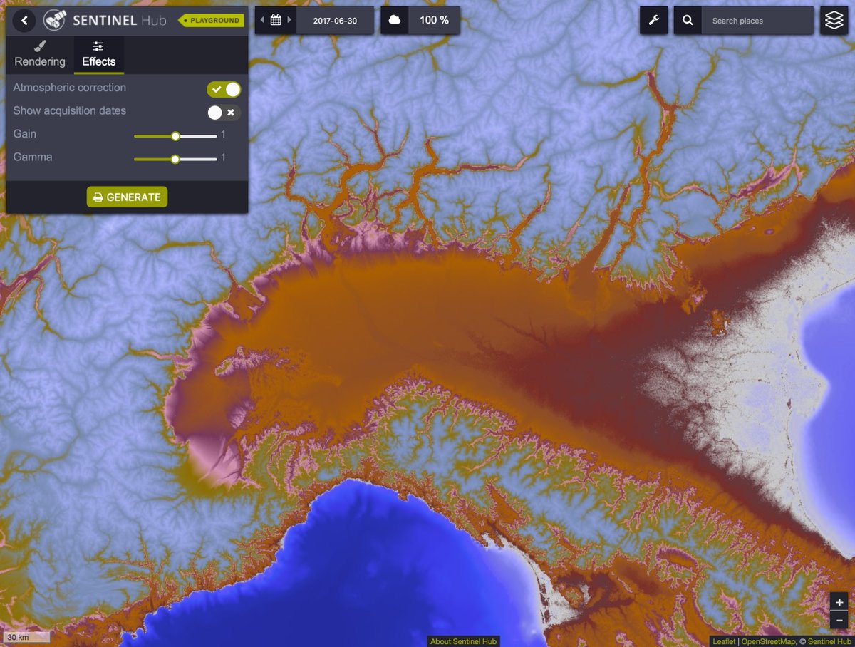
Exploit the benefits of #DigitalElevationModel through #SentinelHub. More in our latest blog: sentinel-hub.com/blog/digital-e… #DEM #EarthObservation
#mostcited 📢A Global-Information-Constrained #DeepLearning Network for #DigitalElevationModel Super-Resolution by Xiaoyi Han, Xiaochuan Ma, Houpu Li and Zhanlong Chen doi.org/10.3390/rs1502… #ImageProcessing
I’m really liking this #DigitalElevationModel produced using #LiDAR #data we collected from one of our #UAV flights for #stockpile inventory

DEM Generation from Multi Satellite PlanetScope Imagery sci.fo/5gu #DigitalElevationModel #SemiGlobalMatching #ShortBaseline @RemoteSens_MDPI

👉👉 A Global-Information-Constrained #DeepLearning Network for #DigitalElevationModel Super-Resolution ✍️ Xiaoyi Han et al. 🔗 mdpi.com/2072-4292/15/2…
Get #digitalelevationmodel data where you need it - anywhere in the globe. #GIS #DEM... bit.ly/2c0o85c

🥳for our new @RemoteSens_MDPI paper to assess @ASI_spazio #COSMOSkyMed #DigitalElevationModel performance for 1) regional-scale systematic mapping of #ArchaeologicalMounds (i.e. #tells) & 2) #looting detection & landscape disturbance #monitoring mdpi.com/1219150


Lido Surface Data NEXTView receives first EASA certification for global terrain data. Read more about the certification & our #aviation terrain product in our press release: ow.ly/U01O50yCKov #DigitalElevationModel #aviationIT

Check out this #DigitalElevationModel... it represents a merger between #airborneLiDAR collected at over 70points per square meter and multi-beam #hydrographic data. #LiDAR #Mapping

#Djibouti now available #HTZMapDownload 20 m resolution #DigitalElevationModel + #Clutter #HTZ #GIS data #Maps #cartography

Something went wrong.
Something went wrong.
United States Trends
- 1. Jonathan Taylor 17.7K posts
- 2. Falcons 29.4K posts
- 3. Colts 48.2K posts
- 4. Daniel Jones 9,660 posts
- 5. Kyle Williams 2,827 posts
- 6. Penix 10.3K posts
- 7. Bijan 6,458 posts
- 8. Liverpool 198K posts
- 9. #Browns 1,725 posts
- 10. Mooney 4,007 posts
- 11. #ForTheShoe 3,616 posts
- 12. Raheem Morris 4,509 posts
- 13. Joe Brady N/A
- 14. Max B 22.2K posts
- 15. Bubba Ventrone N/A
- 16. Tyler Warren 2,235 posts
- 17. #DawgPound 1,334 posts
- 18. Drake London 4,227 posts
- 19. Doku 67.3K posts
- 20. Konate 20.6K posts