#interactivemaps search results

Wondering where to start in the map design process? Check out our Insights page for inspiration! 👉 buff.ly/44qmmj4 #mapdesign #interactivemaps

One of the most popular examples in our Mapbox GL JS Docs is how to create clusters. These unique and dynamic visual markers are a great way to communicate data. See for yourself: buff.ly/3e4xrPu #webdeveloper #webmap #interactivemaps


We've just started the 2nd edition of the course on Interactive Maps in R with @AMarciaBarbosa! 🗺️🌍 We will learn how to create, share, and customize interactive maps in #Rstats 🌐 #InteractiveMaps #SpatialData #rspatial #gis

A draggable point that sticks to the map once dropped...is it magic? 🪄 Just the magic of MapTouchEvents! Create a point that describes its location and travels with the map in this example: buff.ly/3K6uWvE #webmaps #interactivemaps
ICYMI: We updated 1 Million square kilometers of satellite imagery in Europe and Brazil! 😍 See some of the highlights: buff.ly/3OBSERv #mapping #interactivemaps

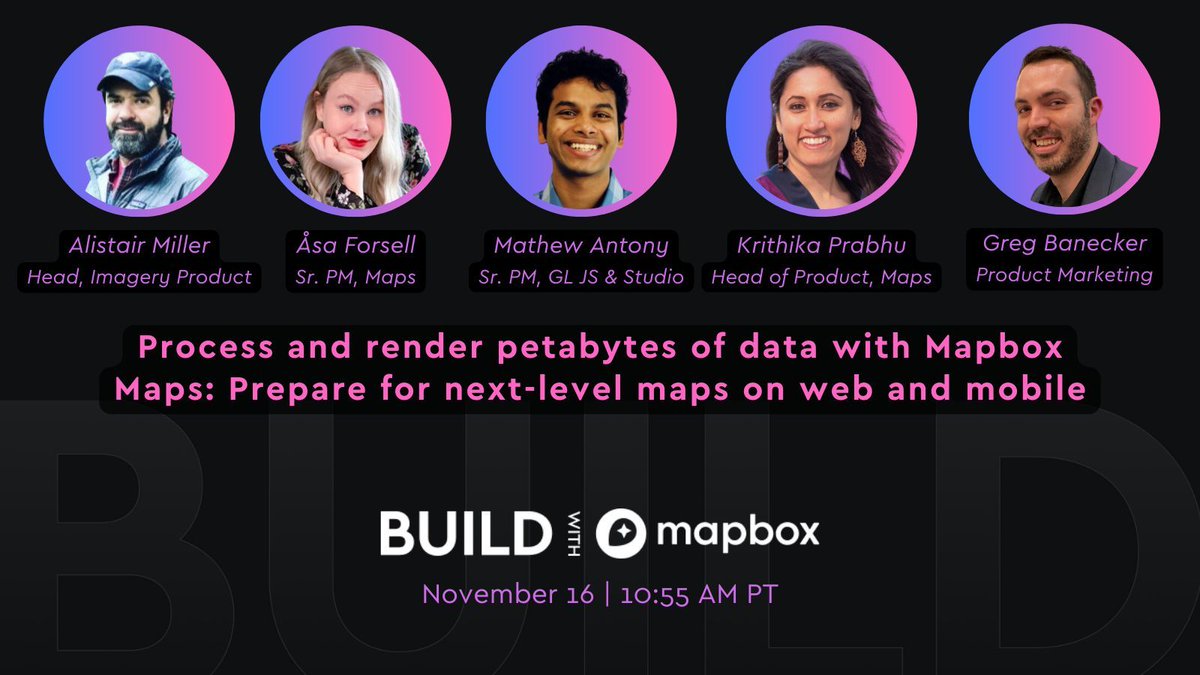
Exciting new features are coming to Mapbox Maps! See how we're improving the developer experience for building maps for web and mobile. 🗺️ 📲 Join us this Thursday: buff.ly/3Dqe9iU #interactivemaps #appdeveloper #geodev
Save the date on April 18th at 9:30am PST for this webinar: Empowering Election Storytelling with Mapbox Interactive Boundaries and Mapping Solutions. #ElectionStorytelling #Mapbox #InteractiveMaps Register here: buff.ly/3TpD7Xy
Making an interactive map with global data? Try out globe view with a custom style to make your map really stand out! Map credit @spatialnodehq. Documentation at buff.ly/3YAfKgb 🌍 #interactivemaps #mapdesign #webmaps
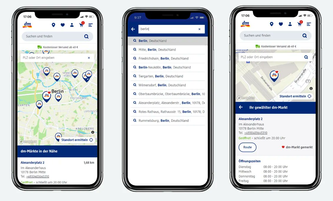
Looking for tips on making it easy for customers to find your nearby stores? Here's how leading European retailer dm uses Mapbox GL JS and Mapbox Geocoding to enhance their customized store locator experience: buff.ly/45l6EpB #retail #interactivemaps #builtwithmapbox
Using the combination of Mapbox Mobile Maps SDK and Mapbox GL JS, the Helium Explorer map achieves lightning-fast rendering on both web and mobile platforms. Learn more: buff.ly/3guz9uo #BuiltWithMapbox #interactivemaps #digitalmaps

🌍🗺️Want to create eye-catching & interactive maps for your projects?🤩Join our #InteractiveMaps course in #Rstats Learn the latest techniques to make your maps pop!🎉Make your data shine on maps that will impress your audience! Enroll now and take your maps to the next level!🚀
Join us in April to learn how to make interactive maps in R: physalia-courses.org/courses-worksh… #rspatial #tmap #cartography #leaflet #mapview #Rstats #DataScience

3D landmarks now available for Houston & Phoenix! 🌇 Mapbox Standard has landmark coverage for 60 global cities and counting. How do we choose which landmarks to design? Learn more: buff.ly/3rYC8nw #mapdesign #mapping #interactivemaps

Replace your camera pan 🍳 with a bounce! 🏀 Custom easing functions in this GL JS example allow the camera to animate in unique and customizable ways. Make this example yourself: buff.ly/3FRL4ii #interactivemaps #webdev
ICYMI: We've made some pretty cool changes to make it easier to build and maintain map styles with Mapbox. See what all the buzz is about 👉 buff.ly/497JR3h #mapping #interactivemaps #developer


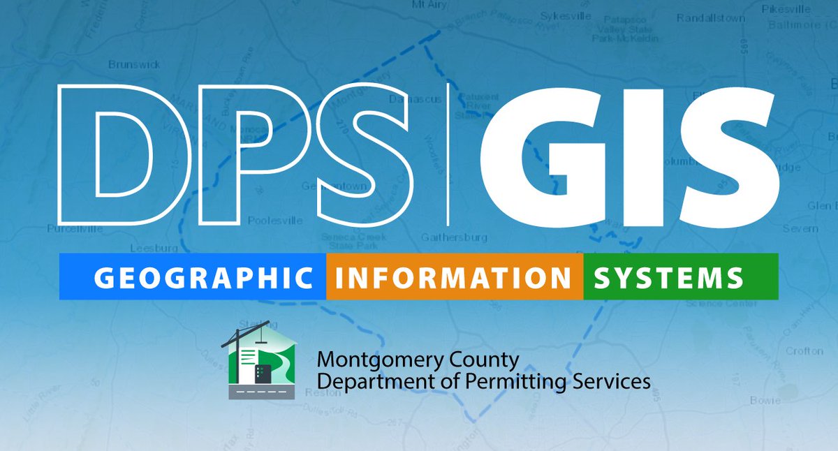
Discover @MontgomeryCoMD latest GIS mapping tools! The Department of Permitting Services has introduced #InteractiveMaps for #floodplains, permitting activity, and commercial use. conduitstreet.mdcounties.org/2024/02/14/mon…

Engage with Mid Bay News' interactive maps for district boundaries and polling locations. #InteractiveMaps midbaynews.com/elections

Engage with Mid Bay News' interactive maps to understand district boundaries and voting locations. #InteractiveMaps midbaynews.com/elections

ift.tt/m8Cyq5p Create an interactive conceptual map with ease and flair! Dive into steps, tips, and tools to visualize ideas like a pro. Your next brainwave? Connected, dynamic, unforgettable. #ConceptualMap #DataViz #InteractiveMaps #Creativity #Storytelling #byAI

Patan for beginners: New bilingual #InteractiveMaps to help #Nepali students rediscover the heritage of historic kingdom Kathmandu Valley may be consumed by urban sprawl, but the historic core of Patan has changed little in the last 400 years. nepalitimes.com/here-now/patan…


Get out alive in Silent Hill f — interactive maps reveal every Hokora, secret path and hidden item 🕯️🗺️ Read more: gettpc.com/get-out-alive-… #SilentHillf #Ebisugaoka #InteractiveMaps #GamingGuide #HiddenItems


🏔️🌊🗺️ Geography made fun! Learn mountains, rivers, and states with colorful, interactive maps. Perfect for quick learning & exam prep. 📚 Save this post for revision! #GeographyMadeEasy #InteractiveMaps #Mountains #Rivers #States #StudyTips #GeographyLearning

Add interactive, detailed maps to your WordPress site with WP Go Maps Lifetime Deal! For $59 one-time, get premium features, gold & visitor-generated markers add-ons, unlim... dealwhizz.com/wp-go-maps-lif… #WPGoMaps #WordPressMaps #InteractiveMaps #LifetimeDeal


🗺️ Devs! 70% of mobile users hunt with maps in 2025. 😜 How do you add epic interactive maps to client sites? Share your tricks: Google Maps, Leaflet, or geo-hacks? Guide users & boost sales! 👇 #WebDev #InteractiveMaps #DevCommunity

Add interactive #Maps on Power Apps, #CanvasApp with Maplytics! bit.ly/4j8toQM #InteractiveMaps #PowerPlatform #AzureIntegration #GeoMapping


What if your map told real stories? With Open User Map, your visitors contribute pins, media, and form data directly to your map. The possibilities? Limitless. Read our full review: buff.ly/Lw4LIvx #OpenUserMap #WordPressPlugin #InteractiveMaps #UserEngagement
How Canvas Apps and #Azure Maps Are Powering Next-Gen #ECommerce Logistics @CRMSoftwareBlog bit.ly/42yG5yS #interactivemaps #EcommerceLogistics #LocationIntelligence #azuremaps


Integrating Google Maps into your WordPress site enhances the user experience, especially when included on key pages like the Contact page. Read more 👉 link.xsquare.com.sg/d1e25960 #ComprehensiveGuide #InteractiveMaps #SEO

Power Up Your Canvas Apps with No Code Interactive Maps: A Game-Changer for #Sales and Field Teams! @maplytics bit.ly/4lxln9T #CanvasApps #InteractiveMaps #MapsIntegration #FieldSales

Interactive Maps on Canvas Apps with Maplytics: The Perfect Duo for #Sales Managers! @maplytics bit.ly/4l7A7fD #canvasapps #InteractiveMaps #CRMsales #CRMdata #d365

Add interactive #Maps on Power Apps, Canvas App with Maplytics! bit.ly/4j8toQM #InteractiveMaps #CanvasApp #AzureMaps #GeoMapping
Interactive Maps on Canvas Apps with Maplytics: The Perfect Duo for #Sales Managers! @maplytics bit.ly/4l7A7fD #canvasapps #InteractiveMaps #CRMsales #CRMdata #d365
A Day in the Life of a #RealEstate Agent Using Maps Integrated in Dynamics 365 bit.ly/4hRMNEG #RealEstateExpert #InteractiveMaps #RealestateAgent #fieldservices

How Canvas Apps and #Azure Maps Are Powering Next-Gen #ECommerce Logistics @CRMSoftwareBlog bit.ly/42yG5yS #InteractiveMaps #ecommercelogistics #AzureMaps #Powerapps


FOGO's interactive maps and visualizations help you understand blockchain networks better. #FOGO #InteractiveMaps @FogoChain

⚡️Attention Community⚡️ Fogo has not launched or endorsed any official NFT collection and has no immediate plans to do so. Any information you receive from other sources is pure speculation. With that being said...it probably wouldn't hurt to follow @FogoNFT 👀👀
Wizards Wanted: Unlock Location Intelligence with Dynamics 365 Maps at Dynamics Minds! bit.ly/43nv8PD #DynamicsMinds #LocationIntelligence #InteractiveMaps #MsDyn365
maplytics.com
Wizards Wanted: Unlock Location Intelligence with Dynamics 365 Maps at Dynamics Minds! - Blog |...
Join Inogic-Maplytics at Dynamics Minds 2025! The ultimate gathering of CRM sorcerers and Power Platform wizards!


Wondering where to start in the map design process? Check out our Insights page for inspiration! 👉 buff.ly/44qmmj4 #mapdesign #interactivemaps
3D landmarks now available for Houston & Phoenix! 🌇 Mapbox Standard has landmark coverage for 60 global cities and counting. How do we choose which landmarks to design? Learn more: buff.ly/3rYC8nw #mapdesign #mapping #interactivemaps
Looking for tips on making it easy for customers to find your nearby stores? Here's how leading European retailer dm uses Mapbox GL JS and Mapbox Geocoding to enhance their customized store locator experience: buff.ly/45l6EpB #retail #interactivemaps #builtwithmapbox
Learn more about custom data 'slots' and what other improvements Mapbox Standard offers in our latest blog post: buff.ly/497JR3h #mapdesign #cartography #interactivemaps #gischat

ICYMI: We updated 1 Million square kilometers of satellite imagery in Europe and Brazil! 😍 See some of the highlights: buff.ly/3OBSERv #mapping #interactivemaps
Using the combination of Mapbox Mobile Maps SDK and Mapbox GL JS, the Helium Explorer map achieves lightning-fast rendering on both web and mobile platforms. Learn more: buff.ly/3guz9uo #BuiltWithMapbox #interactivemaps #digitalmaps
One of the most popular examples in our Mapbox GL JS Docs is how to create clusters. These unique and dynamic visual markers are a great way to communicate data. See for yourself: buff.ly/3e4xrPu #webdeveloper #webmap #interactivemaps
ICYMI: We've made some pretty cool changes to make it easier to build and maintain map styles with Mapbox. See what all the buzz is about 👉 buff.ly/497JR3h #mapping #interactivemaps #developer
Exciting new features are coming to Mapbox Maps! See how we're improving the developer experience for building maps for web and mobile. 🗺️ 📲 Join us this Thursday: buff.ly/3Dqe9iU #interactivemaps #appdeveloper #geodev
We've just started the 2nd edition of the course on Interactive Maps in R with @AMarciaBarbosa! 🗺️🌍 We will learn how to create, share, and customize interactive maps in #Rstats 🌐 #InteractiveMaps #SpatialData #rspatial #gis
Discover @MontgomeryCoMD latest GIS mapping tools! The Department of Permitting Services has introduced #InteractiveMaps for #floodplains, permitting activity, and commercial use. conduitstreet.mdcounties.org/2024/02/14/mon…


Continuamos con la divulgación de los mapas interactivos y el visor 3D. El pasado martes 14 de noviembre tuvimos el placer de explicar el proyecto al claustro del colegio La Compasión Escolapios. #oPENLab #mygreenplace #interactivemaps #3dviewer


Discover our surveyors created to track #malaria drug resistance. These #InteractiveMaps provide researchers and policy-makers with changes in molecular markers over time and location to help monitor the emergence and spread of resistance iddo.org/wwarn/tracking…


Most guests don’t complain — they just skip what they can’t find. Interactive maps fix that. Create smoother guest journeys with YourMap. 👉 Start free [link in bio] #InteractiveMaps #DigitalMaps #Wayfinding #SmartMaps #GuestExperience #VisitorExperience
![getmoonapps's tweet image. Most guests don’t complain — they just skip what they can’t find.
Interactive maps fix that.
Create smoother guest journeys with YourMap.
👉 Start free [link in bio]
#InteractiveMaps #DigitalMaps #Wayfinding #SmartMaps #GuestExperience #VisitorExperience](https://pbs.twimg.com/media/G8hitubaIAA2SbJ.jpg)

Point clustering, pop-ups, custom markers, location searches, and more! Find out how we are making interactive real estate maps easy. Click the link in the first reply. #RealEstateMaps #InteractiveMaps #RealEstateTech #LocationMatters #PropertyMaps


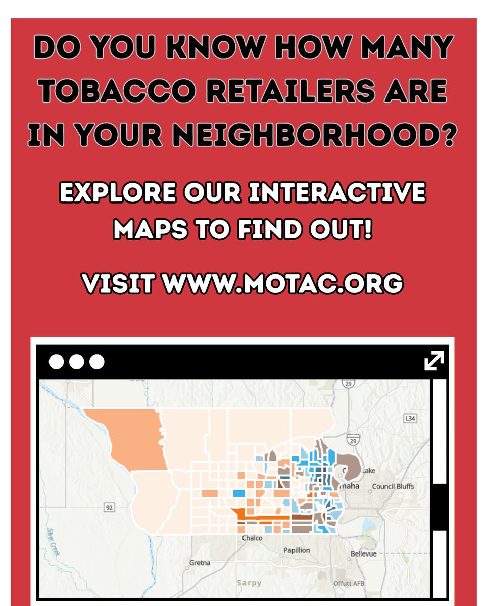
Did you know that areas with many tobacco retailers have higher rates of smoking? Visit motac.org to interact with our maps and see what the tobacco retailer environment looks like where you live, work, or play. #MOTAC #InteractiveMaps


Something went wrong.
Something went wrong.
United States Trends
- 1. Lemon N/A
- 2. McVay N/A
- 3. #Kehlani N/A
- 4. Rams N/A
- 5. Stafford N/A
- 6. Jokic N/A
- 7. Ty Simpson N/A
- 8. Jaden McDaniels N/A
- 9. Bain N/A
- 10. Steelers N/A
- 11. #SECAwards N/A
- 12. Jets N/A
- 13. Nuggets N/A
- 14. Caleb Downs N/A
- 15. DeepSeek V4 N/A
- 16. Enid N/A
- 17. #zzzSpecialProgram N/A
- 18. Eagles N/A
- 19. Beane N/A
- 20. Wack N/A