#spatialdata search results

Context. Clarity. A living map that understands itself. That’s when decisions become smarter, ecosystems grow faster, and onchain truly meets the real world. @integra_layer #Integra #IRL #SpatialData

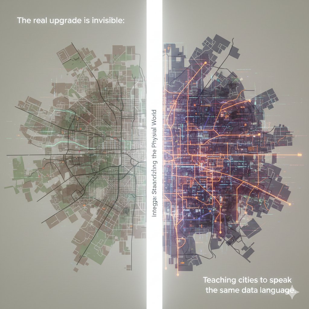
Every ecosystem has data. But only @integra_layer gives it a heartbeat. When movement becomes memory, and land becomes language, cities stop being structures they become stories. And suddenly, the world isn’t just mapped… it’s understood. #Integra #SpatialData #IRL


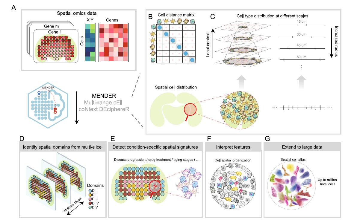
We love learning about new #ComputationalTools for analyzing #SpatialData! MENDER is a novel tissue structure identification tool utilizing cellular neighborhood structures observed across spatial technologies now published in @NatureComms. Learn more: hubs.ly/Q02fCYP20
This is how real estate evolves: not with buzzwords, but with a chain that can actually understand the world it’s securing. #Integra #IRL #SpatialData


🌐 Introducing PA statistical methods: Geographic Information Systems (GIS). This integrates spatial data, ideal for exploring environmental influences on physical activity. GIS requires extensive data handling skills. #SpatialData #PhysicalActivityResearch


Awesome week last week representing both @napari_imaging and #SpatialData @scverse at @EuroSciPy2024. It was great to meet maintainers and contributors to the libraries we use. Also grateful for the opportunity to have a flashlight talk on #numpydantic and a little bit on #LinkML


2 WEEKS AWAY! 🥳 Prevent yourself from future FOMO & sign up for Esri's popular course today: esri.social/xJq350SWk38 #SpatialDataScience #ArcGIS #SpatialData

Happy to share earlier this month, Avipsa Roy, Asst Prof in Urban Planning & Public Policy was invited as a guest lecturer to discuss Spatial Data Science's influence on policy making at IIT Kharagpur, Visva Bharati University, ISI Kolkata, and IISc Bengaluru. #spatialdata #up3


URHIAsti on stage today 11.00 🇪🇪@utuscience @UniTurku #spatialdata #foss4ge @foss4ge @HuDi_Project @BEDLAN_Uralic


Today presenting current status at the #foss4ge2024 Tartu “URHIA's Open Data Journey in Spatial Exploration” 📅Fri, 5.7.2024 at 11.00 📍Omicum building Live stream link available foss4ge.television.ee

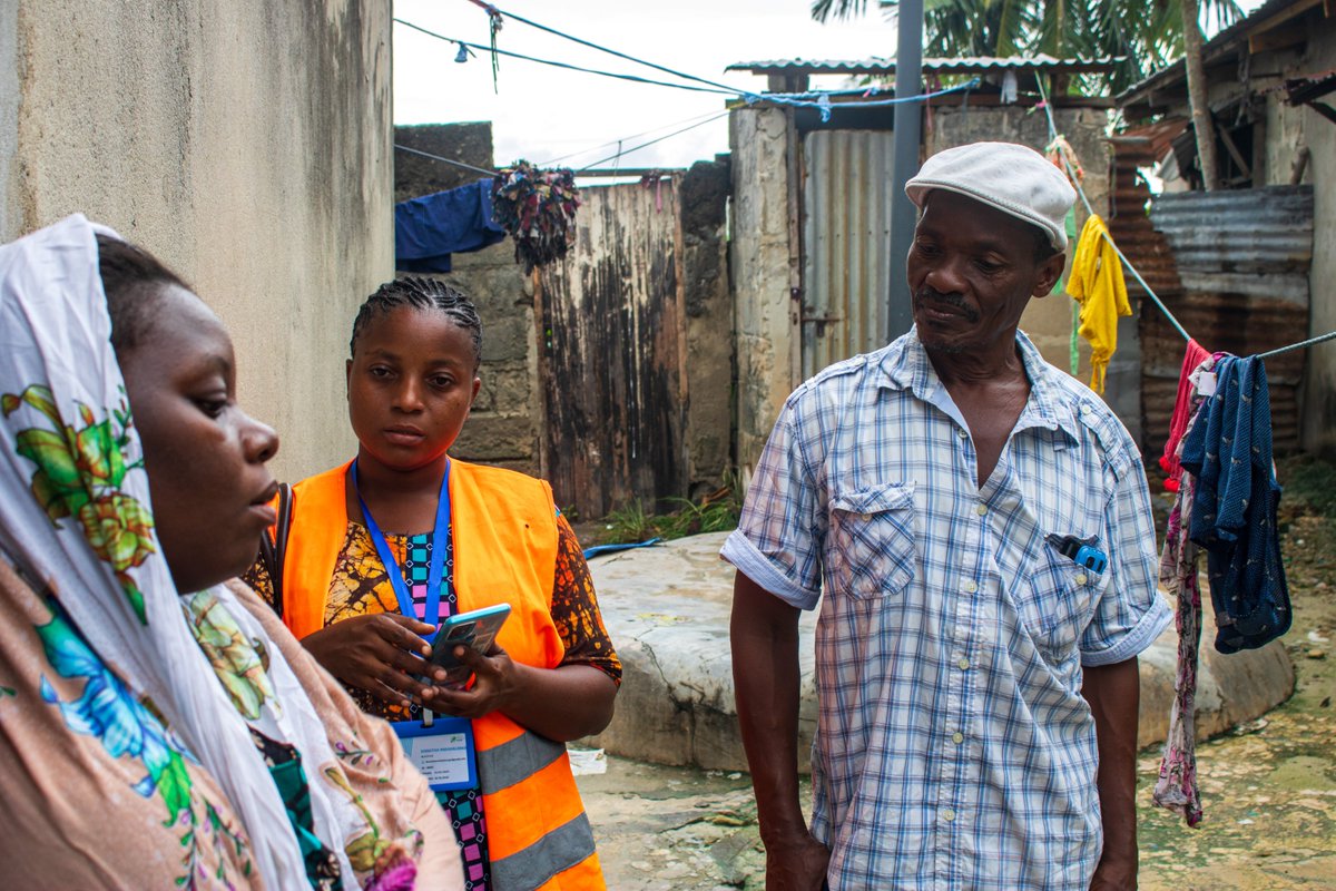
Big up to Wajumbe👏🥳 for aiding mappers on the ground with their invaluable local knowledge & resident trust. They play a crucial role in gathering accurate #spatialdata for the baseline survey & pinpointing initial information, i.e., WCP's locations, dumping sites & waste piles

Applied #SpatialData! #BigData #Analytics #DataScience #AI #MachineLearning #IoT #IIoT #GeoSpatial #Python #RStats #TensorFlow #Java #JavaScript #ReactJS #GoLang #CloudComputing #Serverless #DataScientist #Linux #Programming #Coding #100DaysofCode geni.us/Applied-Spatia…


making spatial data easy for pros and non-gis users, catch the full video exclusively on collide.io #gis #spatialdata #dataplatform

📍 Looking to expand your business to new locations, but worried about the impact on existing sales? You need Cannibalization Analysis! Maximize profits and safeguard existing revenue with this step-by-step tutorial 👉 hubs.ly/Q02wMFYv0 #analytics #spatialdata
📍 Looking to expand your business to new locations, but worried about the impact on existing sites? You need Cannibalization Analysis! Maximize profits and safeguard existing revenue with this step-by-step tutorial 👉 hubs.ly/Q02DqVqK0 #analytics #spatialdata

Data prep shouldn't take longer than the actual analysis. @nextgis geodata: pre-validated, pre-styled, ready to use. Basemaps, buildings, elevation, satellite imagery, landcover, POIs. 50% off Dec 1-5 | Works in any GIS tool linkly.link/2Rlit⚡ #Geodata #GIS #SpatialData


What is @ApacheSedona and what are its common use cases? Discover how this clustering computing system, designed for processing large-scale spatial data, treats spatial data as a first-class citizen. bit.ly/3ZRL24U #ApacheSeonda #SpatialData

What map have you found geoaweseome recently? Spilhaus Ocean Currents map shows how ocean water moves around the world. We love this project! Check it by yourself: arcgis.com/apps/mapviewer… #Geospatial #Geoawesome #SpatialData #cartography #maps #map
Context. Clarity. A living map that understands itself. That’s when decisions become smarter, ecosystems grow faster, and onchain truly meets the real world. @integra_layer #Integra #IRL #SpatialData

Unlock the full potential of your spatial data with Professionals Arabia Co. ✔️ SDE setup (SQL Server, Oracle, PostGIS) ✔️ Multi-user editing & versioning ✔️ Data migration & performance tuning ✔️ Secure access, ArcGIS integration #GIS #ArcGIS #SpatialData

Every ecosystem has data. But only @integra_layer gives it a heartbeat. When movement becomes memory, and land becomes language, cities stop being structures they become stories. And suddenly, the world isn’t just mapped… it’s understood. #Integra #SpatialData #IRL
Data prep shouldn't take longer than the actual analysis. @nextgis geodata: pre-validated, pre-styled, ready to use. Basemaps, buildings, elevation, satellite imagery, landcover, POIs. 50% off Dec 1-5 | Works in any GIS tool linkly.link/2Rlit⚡ #Geodata #GIS #SpatialData

Spatial intelligence is redefining decision-making. With the power of GeoAI, raw geographic data becomes actionable insight accelerating smarter planning, optimised operations, and future-ready innovation. #EmpowerSolutions #GeoAI #SpatialData #DigitalTransformation

This is how real estate evolves: not with buzzwords, but with a chain that can actually understand the world it’s securing. #Integra #IRL #SpatialData

Recognizing this is essential for accurate analysis, stronger models, and better decision-making. Stay with us as we continue exploring core concepts in spatial data science! #SpatialData #GIS #SpatialStatistics #GeospatialAnalysis #DataScience
Recognizing spatial dependence ensures more accurate maps, better models, and smarter real-world decisions. Stay tuned as we continue breaking down powerful concepts in spatial data science! #SpatialData #GeospatialAnalysis #GIS #SpatialDependence #SpatialAutocorrelation
When the physical world becomes structured, every ecosystem built on top becomes smarter. #Integra isn’t adding data. They’re adding understanding. #Integra #SpatialData #InfraLayer #Web3 #KaitoAI


We love learning about new #ComputationalTools for analyzing #SpatialData! MENDER is a novel tissue structure identification tool utilizing cellular neighborhood structures observed across spatial technologies now published in @NatureComms. Learn more: hubs.ly/Q02fCYP20
Context. Clarity. A living map that understands itself. That’s when decisions become smarter, ecosystems grow faster, and onchain truly meets the real world. @integra_layer #Integra #IRL #SpatialData
Every ecosystem has data. But only @integra_layer gives it a heartbeat. When movement becomes memory, and land becomes language, cities stop being structures they become stories. And suddenly, the world isn’t just mapped… it’s understood. #Integra #SpatialData #IRL

More oblique views. Now I'll have to find out how to bring point data to Blender so I can overlay precise locations. I've managed to bring in shapefile but haven't been able to convert that into object. #gis #blender #spatialdata


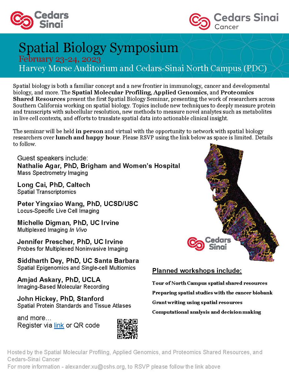
#CedarsSinaiCancer's first #SpatialBiology Symposium is taking place covering topics like new techniques to measure proteins, methods to measure novel analytes, and efforts to translate #spatialdata into clinical insights. Virtual attendees are welcome!
This is how real estate evolves: not with buzzwords, but with a chain that can actually understand the world it’s securing. #Integra #IRL #SpatialData

My latest article, 𝐄𝐱𝐩𝐥𝐨𝐫𝐢𝐧𝐠 𝐋𝐚𝐫𝐠𝐞-𝐬𝐜𝐚𝐥𝐞 𝐑𝐚𝐬𝐭𝐞𝐫 𝐏𝐨𝐩𝐮𝐥𝐚𝐭𝐢𝐨𝐧 𝐃𝐚𝐭𝐚, is out on @TDataScience: towardsdatascience.com/exploring-larg… #geosptaialdata #geodata #spatialdata #datavisualization #datascience #data #datafam #visualization #gis #geography

URHIAsti on stage today 11.00 🇪🇪@utuscience @UniTurku #spatialdata #foss4ge @foss4ge @HuDi_Project @BEDLAN_Uralic
Today presenting current status at the #foss4ge2024 Tartu “URHIA's Open Data Journey in Spatial Exploration” 📅Fri, 5.7.2024 at 11.00 📍Omicum building Live stream link available foss4ge.television.ee

#showcasing #students Jevaughn #spatialdata #analyst #Jamaica jevaughnhenry.wixsite.com/my-site/projec… #ePortfolio #PLUS #creative #drone #projects #Check his #CV & impressive #skills list 😎 #data #visualisation #UAV #Copernicus #DigitalEarth #EO #GI #Geocommunication #UPOL #Geospatial #MSc

Welcome to the 6th day of 12 Days of NanoString! Interested in leaping to single-cell spatial in these applications? nanostring.com/events/spatial… #SpatialData #CellSegmentation #SpatialTranscriptomics #SingleCellImaging

🌐 Introducing PA statistical methods: Geographic Information Systems (GIS). This integrates spatial data, ideal for exploring environmental influences on physical activity. GIS requires extensive data handling skills. #SpatialData #PhysicalActivityResearch

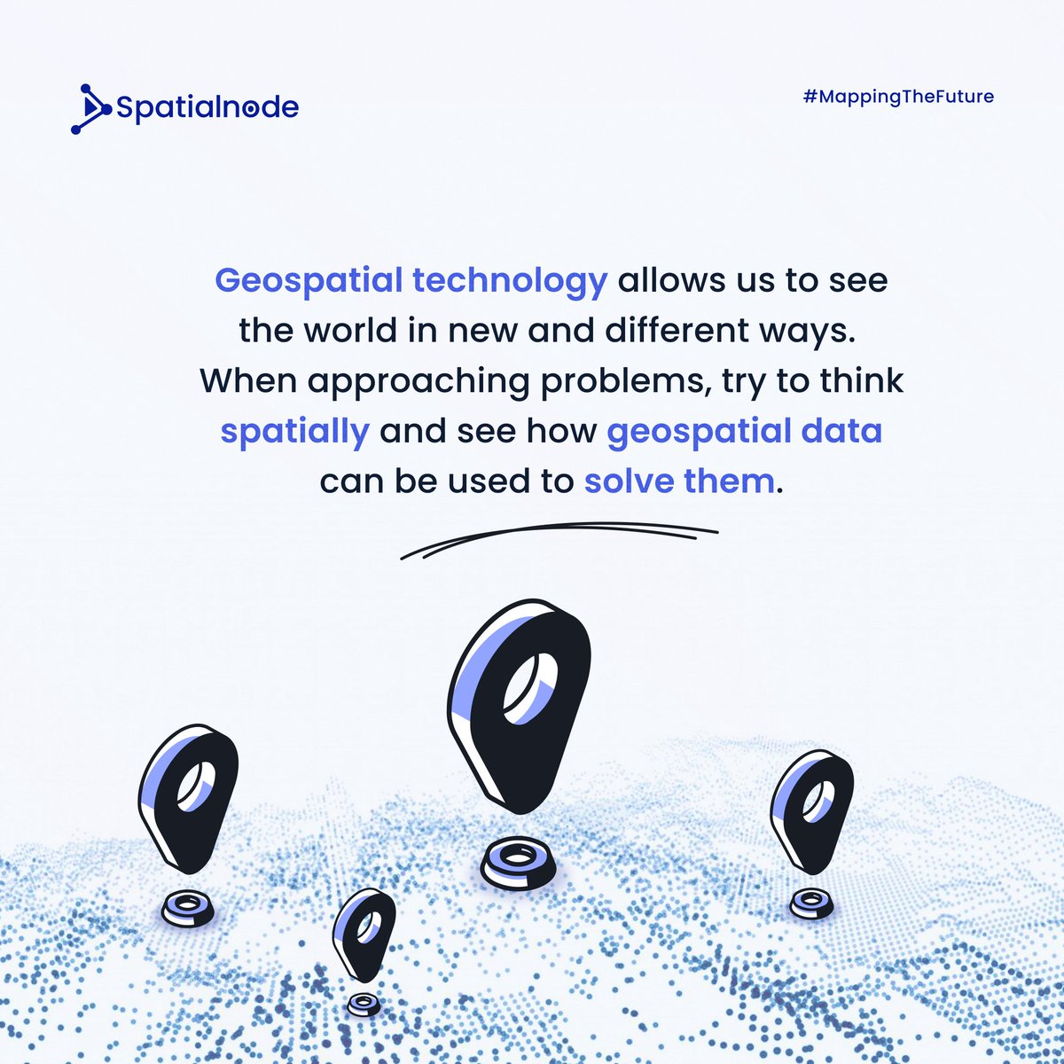
Spatialnode Monday Tips It's a new week! Let's think spatially this week! #geospatial #mondaymotivation #spatialdata
Applied #SpatialData! #BigData #Analytics #DataScience #AI #MachineLearning #IoT #IIoT #GeoSpatial #Python #RStats #TensorFlow #Java #JavaScript #ReactJS #GoLang #CloudComputing #Serverless #DataScientist #Linux #Programming #Coding #100DaysofCode geni.us/Applied-Spatia…

Dr. Urooj Saeed Senior Specialist GIS, presented GIS data sets, layers and analysis. The interactive session with CERP team included discussion on GIS & RS data, attributed data, spatial patterns & spatial data repository and big data repository. #DataAnalytics #spatialdata

My recent article, 𝐄𝐱𝐩𝐥𝐨𝐫𝐢𝐧𝐠 𝐋𝐚𝐫𝐠𝐞-𝐬𝐜𝐚𝐥𝐞 𝐑𝐚𝐬𝐭𝐞𝐫 𝐏𝐨𝐩𝐮𝐥𝐚𝐭𝐢𝐨𝐧 𝐃𝐚𝐭𝐚, published on @TDataScience: towardsdatascience.com/exploring-larg… @WorldPopProject #geosptaialdata #geodata #spatialdata #gis #geography #datascience #datavisualizatiom #ai


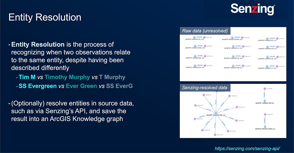
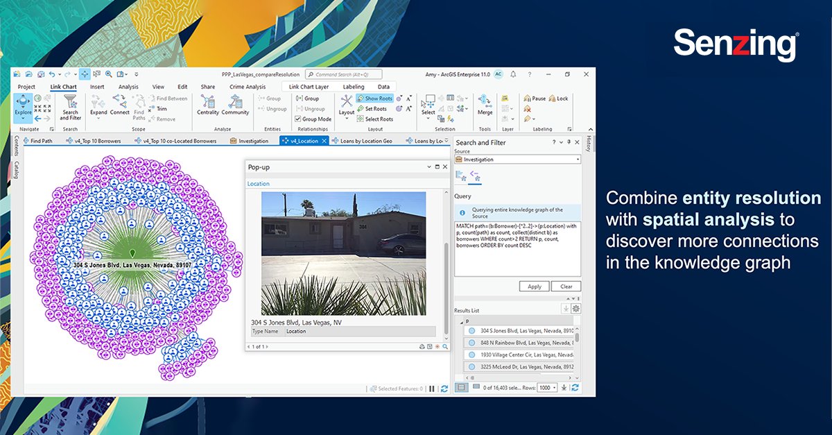
Last week my team and I attended #EsriFedGIS2023. @Senzing and @Esri have partnered to merge #NonSpatial third-party data together with #SpatialData using #ArcGIS Knowledge and perform link analysis using #ArcGISpro. #ArcGISKnowledge #SenzingPartner #ESRIPartner
Awesome week last week representing both @napari_imaging and #SpatialData @scverse at @EuroSciPy2024. It was great to meet maintainers and contributors to the libraries we use. Also grateful for the opportunity to have a flashlight talk on #numpydantic and a little bit on #LinkML

An experienced data analyst provides tips and best practices for managing GIS workflows. esri.social/EK0y50R80N6 @URISA #DataAnalysis #GISWorkflow #SpatialData #DataManagement


This Thursday's #GEOGSeminar: @knaaptime from San Diego State University's @spatialucr will discuss his research on racial residential segregation: 📅 April 20 ⏰ 3:45 p.m. EDT 📌 Room 325 at River Road (+ Zoom) go.umd.edu/racialsegregat… #urbansocialscience #spatialdata

Something went wrong.
Something went wrong.
United States Trends
- 1. rUSD N/A
- 2. #DMDCHARITY2025 832K posts
- 3. #TusksUp N/A
- 4. #AEWDynamite 21K posts
- 5. #TheChallenge41 2,231 posts
- 6. Diddy 74.4K posts
- 7. #Survivor49 2,932 posts
- 8. Earl Campbell 2,114 posts
- 9. seokjin 159K posts
- 10. Free Tina 13.9K posts
- 11. Yeremi N/A
- 12. Steve Cropper 6,718 posts
- 13. Jamal Murray 7,539 posts
- 14. Monkey Wards N/A
- 15. Milo 12.6K posts
- 16. Californians 6,661 posts
- 17. Isaiah Stewart 1,782 posts
- 18. Metroid Prime 4 12.2K posts
- 19. Ryan Nembhard 3,858 posts
- 20. fnaf 2 17K posts