#loopcurrent search results

So... I've noticed this video that has been put out by @WPBF25News and a few others, along with the sharing of that video. Compare for yourself, WPBF vs The ACTUAL NOAA #LoopCurrent ... of ... today 10/3/18... the 2nd photo is of NOAA Is this responsible of you @WPBF_Cris ?


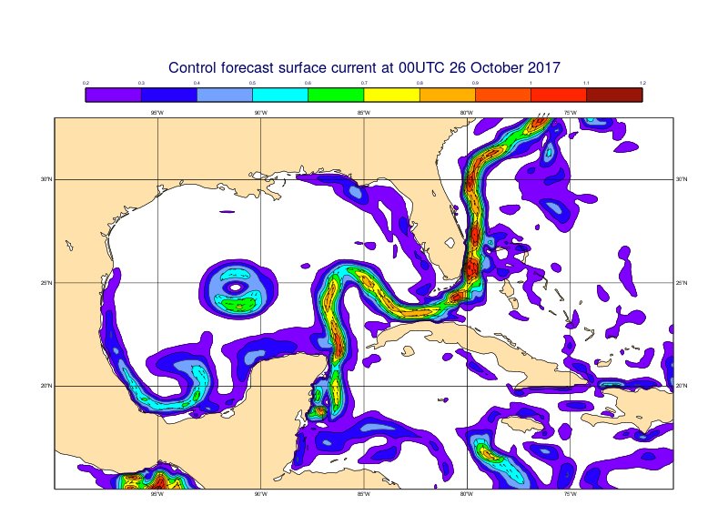
The #LoopCurrent in the Gulf of Mexico captured in the control forecast of the ocean model. This circulation can affect hurricane intensity.

#LoopCurrent #GulfStream #GulfofMexico #oilspill http://twitpic.com/1pq4s4

Closing out 2020 with some good news! I am excited to share the 2nd paper of my Ph.D., with Prof. @DaveNolan305 and Prof. Nick Shay, on the ageostrophic flow during eddy-front interaction in the Loop Current (LC) system, Gulf of Mexico. #LoopCurrent #eddy doi.org/10.1175/JPO-D-…
#Idalia is now forecasted to become a major #hurricane (cat 3+) as it passes over the warm #LoopCurrent. Stay safe, everyone!

@stallcup http://twitpic.com/1q3phg - Thanks! #oilspill #LoopCurrent #Gulf #NOAA #BP #GulfOfMexico #ocean #currents #surfacetemp

Earlier today, Disturbance 3 has rapidly intensified to Tropical Storm Alberto once it entered the Gulf of Mexico and interacted with the warm water of the Loop Current, which serves as a fuel for tropical storms. @LSU @LCEAlliance #LoopCurrent #LoopCurrentEddy


Joe Kuehl from @UDelaware joins us this Friday. Hope to see you all there. #usf #loopcurrent bit.ly/2HOpTNp


Forecasters at @NOAA are predicting above-average #hurricane activity this year. #WHOI scientists are actively working to study the physical aspects that impact hurricanes and their intensities—for example by studying the Gulf of Mexico #LoopCurrent. 📸 @NASA

LCE Update: Narrowing of the Loop Current along 24ºN may soon lead to the formation of a new eddy. In the meantime, Eddy Quantum remains active in the northern GOM. (Imagery: LSU Earth Scan Laboratory Nighttime composite) #LSU #LoopCurrent #LoopCurrentEddy #LCEA

ROFFS image - #oilspill meets #LoopCurrent. #NASA #WhyWeNeedNASA #satellite #ocean #NOAA http://twitpic.com/1of91x

Official #Milton track crosses the southern most part of the #LoopCurrent. The good news is that it doesn't move directly over it, but there is still a 6 hour window where it will thrive over high ocean heat content. That window is between 8PM this evening and 2AM Wednesday…


4 pm: PTC1 still no closed circulation nor are the strongest winds even close to the center, they're some 250 miles away near Key West in the strongest thunderstorms. While over the #loopcurrent, the storm isn't able to take advantage due to dry air and wind shear! #BeOn4 @wwltv

#NOAA diagram: #LoopCurrent -> Florida Current -> Gulf Stream. Holy Crap. #oilspill http://twitpic.com/1of56f

#Unusually warm subsurface waters on the West Florida Shelf, linked to a stalled #LoopCurrent, contributed to #Hurricane Ian’s rapid intensification. Monitoring these layers may improve hurricane forecasts. @theAGU doi.org/g9t8zv phys.org/news/2025-07-p…
phys.org
Study finds 'pressure point' in the Gulf could drive hurricane strength
Driven by high temperatures in the Gulf, Hurricane Ian rapidly intensified from a Category 3 to Category 5 before making landfall in Southwest Florida on September 28, 2022. The deadly storm caught...

Maps of #LoopCurrent posted by @madlolscientist: http://twitpic.com/1of56f | http://twitpic.com/1pq4s4 | http://twitpic.com/1of91x

Looking at FishTrack’s satellite imagery to pinpoint the location of the Loop Current and a warm water eddy heading S/SW toward Louisiana. View latest conditions at FishTrack.com. #sst #sateliteimagery #loopcurrent #gulfofmexico #landsucks ift.tt/2Fyw72K


Is the #loopcurrent going to save #FortMyers & #Naples #FL from the #BP #oilspill ? - http://lnk.ms/BTRfx
#Unusually warm subsurface waters on the West Florida Shelf, linked to a stalled #LoopCurrent, contributed to #Hurricane Ian’s rapid intensification. Monitoring these layers may improve hurricane forecasts. @theAGU doi.org/g9t8zv phys.org/news/2025-07-p…
phys.org
Study finds 'pressure point' in the Gulf could drive hurricane strength
Driven by high temperatures in the Gulf, Hurricane Ian rapidly intensified from a Category 3 to Category 5 before making landfall in Southwest Florida on September 28, 2022. The deadly storm caught...
Official #Milton track crosses the southern most part of the #LoopCurrent. The good news is that it doesn't move directly over it, but there is still a 6 hour window where it will thrive over high ocean heat content. That window is between 8PM this evening and 2AM Wednesday…

Neat observation from our midnight shift last night: large swath of higher SSE winds over the #GulfofMexico #LoopCurrent yesterday. Why?👇 Warmer SSTs➡️Warmer atmospheric boundary layer➡️Steeper temperature lapse rates➡️Greater downward air movement➡️higher surface winds

“You don’t ass around with the loop,” a retired general told @VirginiaGewin, who spent the fall with @theNASEM’s Understanding Gulf Ocean Systems initiative as the team works to demystify the #LoopCurrent’s erratic behavior. Photos by @virginiahanusik. issues.org/loop-current-g…
issues.org
A Scientific “Forced Marriage” Takes on the Mysteries of the Loop Current
UGOS, an effort to collect data and predict the Loop Current’s erratic behavior, is compelling scientists to cross disciplines and borders.
#Idalia is now forecasted to become a major #hurricane (cat 3+) as it passes over the warm #LoopCurrent. Stay safe, everyone!

Makes me think of Opal (1995) and Charley (2004) #loopcurrent

What's the relationship between the #LoopCurrent in the #GulfofMexico and #hurricanes? And how do underwater #gliders help forecasters determine the strength and intensity of storms? Learn more here: gcoos.org/hurricane-glid…

4 pm: PTC1 still no closed circulation nor are the strongest winds even close to the center, they're some 250 miles away near Key West in the strongest thunderstorms. While over the #loopcurrent, the storm isn't able to take advantage due to dry air and wind shear! #BeOn4 @wwltv
Forecasters at @NOAA are predicting above-average #hurricane activity this year. #WHOI scientists are actively working to study the physical aspects that impact hurricanes and their intensities—for example by studying the Gulf of Mexico #LoopCurrent. 📸 @NASA

This year's Loop Current' looks as if hurricane season will be tough #hurricane #loopcurrent #evacuation #season instagram.com/p/CdyXBqyjcZq/…

Bad news for the 2022 hurricane season: The Loop Current, a fueler of monster storms, is looking a lot like it did in 2005, the year of Katrina via @TC_Africa theconversation.com/bad-news-for-t… Be Prepared! 3-5 days of food and water. Evacuation Plan. @fema @11thHour @CNN @Newsweek @NPR


Are you disaster-ready? Reports of the Gulf of Mexico's #LoopCurrent indicate we're in for another devastating and deadly #hurricaneseason in 2022. (1/2) nola.com/news/hurricane…

Bad news for the 2022 hurricane season: The Loop Current, a fueler of monster storms, is looking a lot like it did in 2005, the year of Katrina, op-ed by Prof. Nick Shay, bit.ly/3LrlC3d via @ConversationUS #HurricaneSeason #LoopCurrent
The #GCOOS #Glider Dashboard (gandalf.gcoos.org) is tracking a record 11 gliders in the Gulf and Atlantic, most deployed as part of the hurricane picket line. These are collecting data within #LoopCurrent eddy features. Read more: gcoos.org/record-gliders/
My Ph.D. advisor Prof. Nick Shay (@UMiamiRSMAS) explains how a warm #LoopCurrent Eddy fueled the rapid intensification of #hurricane #Ida to a Category 4 in the Gulf of Mexico, causing severe damage in Louisiana. theconversation.com/hurricane-ida-…
theconversation.com
Hurricane Ida turned into a monster thanks to a giant warm patch in the Gulf of Mexico – here’s...
Ida exploded from a weak hurricane to a powerful Category 4 storm in less than 24 hours, thanks to heat from an ocean eddy. An oceanographer explains its rapid intensification.

#ida does have an extended #loopcurrent under it in the GoM which is an interesting combination.

You can see where the eye of #Ida is currently at (red arrow) vs. where the forecast track is (blue arrow). This will have ramifications downstream. via @zoom_earth

My paper on the ageostrophic flow in the Loop Current Gulf of Mexico is out in its final format! 🎉 #LoopCurrent #eddies @UMiamiRSMAS
Joe Kuehl from @UDelaware joins us this Friday. Hope to see you all there. #usf #loopcurrent bit.ly/2HOpTNp
Closing out 2020 with some good news! I am excited to share the 2nd paper of my Ph.D., with Prof. @DaveNolan305 and Prof. Nick Shay, on the ageostrophic flow during eddy-front interaction in the Loop Current (LC) system, Gulf of Mexico. #LoopCurrent #eddy doi.org/10.1175/JPO-D-…
Forecasters at @NOAA are predicting above-average #hurricane activity this year. #WHOI scientists are actively working to study the physical aspects that impact hurricanes and their intensities—for example by studying the Gulf of Mexico #LoopCurrent. 📸 @NASA
So... I've noticed this video that has been put out by @WPBF25News and a few others, along with the sharing of that video. Compare for yourself, WPBF vs The ACTUAL NOAA #LoopCurrent ... of ... today 10/3/18... the 2nd photo is of NOAA Is this responsible of you @WPBF_Cris ?
4 pm: PTC1 still no closed circulation nor are the strongest winds even close to the center, they're some 250 miles away near Key West in the strongest thunderstorms. While over the #loopcurrent, the storm isn't able to take advantage due to dry air and wind shear! #BeOn4 @wwltv
#Idalia is now forecasted to become a major #hurricane (cat 3+) as it passes over the warm #LoopCurrent. Stay safe, everyone!
Looking at FishTrack’s satellite imagery to pinpoint the location of the Loop Current and a warm water eddy heading S/SW toward Louisiana. View latest conditions at FishTrack.com. #sst #sateliteimagery #loopcurrent #gulfofmexico #landsucks ift.tt/2Fyw72K
The #LoopCurrent in the Gulf of Mexico captured in the control forecast of the ocean model. This circulation can affect hurricane intensity.
Earlier today, Disturbance 3 has rapidly intensified to Tropical Storm Alberto once it entered the Gulf of Mexico and interacted with the warm water of the Loop Current, which serves as a fuel for tropical storms. @LSU @LCEAlliance #LoopCurrent #LoopCurrentEddy
LCE Update: Narrowing of the Loop Current along 24ºN may soon lead to the formation of a new eddy. In the meantime, Eddy Quantum remains active in the northern GOM. (Imagery: LSU Earth Scan Laboratory Nighttime composite) #LSU #LoopCurrent #LoopCurrentEddy #LCEA
Official #Milton track crosses the southern most part of the #LoopCurrent. The good news is that it doesn't move directly over it, but there is still a 6 hour window where it will thrive over high ocean heat content. That window is between 8PM this evening and 2AM Wednesday…
#LoopCurrent #GulfStream #GulfofMexico #oilspill http://twitpic.com/1pq4s4

Our next webinar is scheduled and the focus is on the #LoopCurrent in the #GulfofMexico! Reserve your spot - space is limited: secoora.org/what-do-we-kno… @GoMAlliance @NASEM_Gulf @GCOOS1 @IOOSAssociation @usioosgov

@stallcup http://twitpic.com/1q3phg - Thanks! #oilspill #LoopCurrent #Gulf #NOAA #BP #GulfOfMexico #ocean #currents #surfacetemp

The #GulfofMexico Loop Current is the subject of a new data system called #GulfHub. HRI has received a grant to create GulfHub to house valuable oceanographic #LoopCurrent data to help researchers, emergency management entities, and resource managers: bit.ly/2:W8nZic

What's the relationship between the #LoopCurrent in the #GulfofMexico and #hurricanes? And how do underwater #gliders help forecasters determine the strength and intensity of storms? Learn more here: gcoos.org/hurricane-glid…

Improved marginal seas #salinity structure by SMOS-SMAP fusion. Last #Mississippi discharge flowing against #LoopCurrent @ESA_EO @NASASMAP
ROFFS image - #oilspill meets #LoopCurrent. #NASA #WhyWeNeedNASA #satellite #ocean #NOAA http://twitpic.com/1of91x
#NOAA diagram: #LoopCurrent -> Florida Current -> Gulf Stream. Holy Crap. #oilspill http://twitpic.com/1of56f

RT @madlolscientist: @stallcup http://twitpic.com/1q3phg - Thanks! #oilspill #LoopCurrent #Gulf #NOAA #BP #GulfOfMe... http://ow.ly/17sOGk
Something went wrong.
Something went wrong.
United States Trends
- 1. #UFC322 197K posts
- 2. Islam 312K posts
- 3. #LingTaoHeungAnniversary 664K posts
- 4. LING BA TAO HEUNG 663K posts
- 5. Morales 39.7K posts
- 6. #byucpl N/A
- 7. Wuhan 12.1K posts
- 8. Ilia 8,987 posts
- 9. #GirlPower N/A
- 10. Valentina 17K posts
- 11. Prates 38.2K posts
- 12. #INDvsSA 19.1K posts
- 13. Khabib 16.1K posts
- 14. Georgia 90.8K posts
- 15. Dagestan 4,396 posts
- 16. Sark 6,462 posts
- 17. Topuria 7,100 posts
- 18. Shevchenko 13.7K posts
- 19. Dillon Danis 16.3K posts
- 20. Kirby 19.2K posts