#loopcurrent 搜尋結果

So... I've noticed this video that has been put out by @WPBF25News and a few others, along with the sharing of that video. Compare for yourself, WPBF vs The ACTUAL NOAA #LoopCurrent ... of ... today 10/3/18... the 2nd photo is of NOAA Is this responsible of you @WPBF_Cris ?


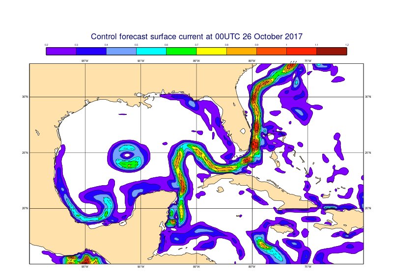
The #LoopCurrent in the Gulf of Mexico captured in the control forecast of the ocean model. This circulation can affect hurricane intensity.

#Idalia is now forecasted to become a major #hurricane (cat 3+) as it passes over the warm #LoopCurrent. Stay safe, everyone!

Closing out 2020 with some good news! I am excited to share the 2nd paper of my Ph.D., with Prof. @DaveNolan305 and Prof. Nick Shay, on the ageostrophic flow during eddy-front interaction in the Loop Current (LC) system, Gulf of Mexico. #LoopCurrent #eddy doi.org/10.1175/JPO-D-…

#LoopCurrent #GulfStream #GulfofMexico #oilspill http://twitpic.com/1pq4s4
@stallcup http://twitpic.com/1q3phg - Thanks! #oilspill #LoopCurrent #Gulf #NOAA #BP #GulfOfMexico #ocean #currents #surfacetemp

LCE Update: Narrowing of the Loop Current along 24ºN may soon lead to the formation of a new eddy. In the meantime, Eddy Quantum remains active in the northern GOM. (Imagery: LSU Earth Scan Laboratory Nighttime composite) #LSU #LoopCurrent #LoopCurrentEddy #LCEA

Earlier today, Disturbance 3 has rapidly intensified to Tropical Storm Alberto once it entered the Gulf of Mexico and interacted with the warm water of the Loop Current, which serves as a fuel for tropical storms. @LSU @LCEAlliance #LoopCurrent #LoopCurrentEddy

ROFFS image - #oilspill meets #LoopCurrent. #NASA #WhyWeNeedNASA #satellite #ocean #NOAA http://twitpic.com/1of91x

Official #Milton track crosses the southern most part of the #LoopCurrent. The good news is that it doesn't move directly over it, but there is still a 6 hour window where it will thrive over high ocean heat content. That window is between 8PM this evening and 2AM Wednesday…


Joe Kuehl from @UDelaware joins us this Friday. Hope to see you all there. #usf #loopcurrent bit.ly/2HOpTNp


Maps of #LoopCurrent posted by @madlolscientist: http://twitpic.com/1of56f | http://twitpic.com/1pq4s4 | http://twitpic.com/1of91x
#NOAA diagram: #LoopCurrent -> Florida Current -> Gulf Stream. Holy Crap. #oilspill http://twitpic.com/1of56f

Forecasters at @NOAA are predicting above-average #hurricane activity this year. #WHOI scientists are actively working to study the physical aspects that impact hurricanes and their intensities—for example by studying the Gulf of Mexico #LoopCurrent. 📸 @NASA


4 pm: PTC1 still no closed circulation nor are the strongest winds even close to the center, they're some 250 miles away near Key West in the strongest thunderstorms. While over the #loopcurrent, the storm isn't able to take advantage due to dry air and wind shear! #BeOn4 @wwltv


#Unusually warm subsurface waters on the West Florida Shelf, linked to a stalled #LoopCurrent, contributed to #Hurricane Ian’s rapid intensification. Monitoring these layers may improve hurricane forecasts. @theAGU doi.org/g9t8zv phys.org/news/2025-07-p…


Looking at FishTrack’s satellite imagery to pinpoint the location of the Loop Current and a warm water eddy heading S/SW toward Louisiana. View latest conditions at FishTrack.com. #sst #sateliteimagery #loopcurrent #gulfofmexico #landsucks ift.tt/2Fyw72K


<URGENT UPDATE> Oil closes on Florida: Spill nears #pensacola Bch; sheen spotted 12km away. http://bit.ly/awDkbd #oilspill #loopcurrent
Deepwater Horizon oil spill trajectory #forecast: 3 of 4 computer models show #oilspill going into #LoopCurrent http://ow.ly/1Mf5H
#Unusually warm subsurface waters on the West Florida Shelf, linked to a stalled #LoopCurrent, contributed to #Hurricane Ian’s rapid intensification. Monitoring these layers may improve hurricane forecasts. @theAGU doi.org/g9t8zv phys.org/news/2025-07-p…
Official #Milton track crosses the southern most part of the #LoopCurrent. The good news is that it doesn't move directly over it, but there is still a 6 hour window where it will thrive over high ocean heat content. That window is between 8PM this evening and 2AM Wednesday…

Neat observation from our midnight shift last night: large swath of higher SSE winds over the #GulfofMexico #LoopCurrent yesterday. Why?👇 Warmer SSTs➡️Warmer atmospheric boundary layer➡️Steeper temperature lapse rates➡️Greater downward air movement➡️higher surface winds

“You don’t ass around with the loop,” a retired general told @VirginiaGewin, who spent the fall with @theNASEM’s Understanding Gulf Ocean Systems initiative as the team works to demystify the #LoopCurrent’s erratic behavior. Photos by @virginiahanusik. issues.org/loop-current-g…

#Idalia is now forecasted to become a major #hurricane (cat 3+) as it passes over the warm #LoopCurrent. Stay safe, everyone!

Makes me think of Opal (1995) and Charley (2004) #loopcurrent

What's the relationship between the #LoopCurrent in the #GulfofMexico and #hurricanes? And how do underwater #gliders help forecasters determine the strength and intensity of storms? Learn more here: gcoos.org/hurricane-glid…

4 pm: PTC1 still no closed circulation nor are the strongest winds even close to the center, they're some 250 miles away near Key West in the strongest thunderstorms. While over the #loopcurrent, the storm isn't able to take advantage due to dry air and wind shear! #BeOn4 @wwltv
Forecasters at @NOAA are predicting above-average #hurricane activity this year. #WHOI scientists are actively working to study the physical aspects that impact hurricanes and their intensities—for example by studying the Gulf of Mexico #LoopCurrent. 📸 @NASA


This year's Loop Current' looks as if hurricane season will be tough #hurricane #loopcurrent #evacuation #season instagram.com/p/CdyXBqyjcZq/…

Bad news for the 2022 hurricane season: The Loop Current, a fueler of monster storms, is looking a lot like it did in 2005, the year of Katrina via @TC_Africa theconversation.com/bad-news-for-t… Be Prepared! 3-5 days of food and water. Evacuation Plan. @fema @11thHour @CNN @Newsweek @NPR


Are you disaster-ready? Reports of the Gulf of Mexico's #LoopCurrent indicate we're in for another devastating and deadly #hurricaneseason in 2022. (1/2) nola.com/news/hurricane…

Bad news for the 2022 hurricane season: The Loop Current, a fueler of monster storms, is looking a lot like it did in 2005, the year of Katrina, op-ed by Prof. Nick Shay, bit.ly/3LrlC3d via @ConversationUS #HurricaneSeason #LoopCurrent
The #GCOOS #Glider Dashboard (gandalf.gcoos.org) is tracking a record 11 gliders in the Gulf and Atlantic, most deployed as part of the hurricane picket line. These are collecting data within #LoopCurrent eddy features. Read more: gcoos.org/record-gliders/
My Ph.D. advisor Prof. Nick Shay (@UMiamiRSMAS) explains how a warm #LoopCurrent Eddy fueled the rapid intensification of #hurricane #Ida to a Category 4 in the Gulf of Mexico, causing severe damage in Louisiana. theconversation.com/hurricane-ida-…


#ida does have an extended #loopcurrent under it in the GoM which is an interesting combination.

You can see where the eye of #Ida is currently at (red arrow) vs. where the forecast track is (blue arrow). This will have ramifications downstream. via @zoom_earth

My paper on the ageostrophic flow in the Loop Current Gulf of Mexico is out in its final format! 🎉 #LoopCurrent #eddies @UMiamiRSMAS
Closing out 2020 with some good news! I am excited to share the 2nd paper of my Ph.D., with Prof. @DaveNolan305 and Prof. Nick Shay, on the ageostrophic flow during eddy-front interaction in the Loop Current (LC) system, Gulf of Mexico. #LoopCurrent #eddy doi.org/10.1175/JPO-D-…
#Idalia is now forecasted to become a major #hurricane (cat 3+) as it passes over the warm #LoopCurrent. Stay safe, everyone!
So... I've noticed this video that has been put out by @WPBF25News and a few others, along with the sharing of that video. Compare for yourself, WPBF vs The ACTUAL NOAA #LoopCurrent ... of ... today 10/3/18... the 2nd photo is of NOAA Is this responsible of you @WPBF_Cris ?
The #LoopCurrent in the Gulf of Mexico captured in the control forecast of the ocean model. This circulation can affect hurricane intensity.
Joe Kuehl from @UDelaware joins us this Friday. Hope to see you all there. #usf #loopcurrent bit.ly/2HOpTNp
LCE Update: Narrowing of the Loop Current along 24ºN may soon lead to the formation of a new eddy. In the meantime, Eddy Quantum remains active in the northern GOM. (Imagery: LSU Earth Scan Laboratory Nighttime composite) #LSU #LoopCurrent #LoopCurrentEddy #LCEA
Looking at FishTrack’s satellite imagery to pinpoint the location of the Loop Current and a warm water eddy heading S/SW toward Louisiana. View latest conditions at FishTrack.com. #sst #sateliteimagery #loopcurrent #gulfofmexico #landsucks ift.tt/2Fyw72K
Forecasters at @NOAA are predicting above-average #hurricane activity this year. #WHOI scientists are actively working to study the physical aspects that impact hurricanes and their intensities—for example by studying the Gulf of Mexico #LoopCurrent. 📸 @NASA
Earlier today, Disturbance 3 has rapidly intensified to Tropical Storm Alberto once it entered the Gulf of Mexico and interacted with the warm water of the Loop Current, which serves as a fuel for tropical storms. @LSU @LCEAlliance #LoopCurrent #LoopCurrentEddy
4 pm: PTC1 still no closed circulation nor are the strongest winds even close to the center, they're some 250 miles away near Key West in the strongest thunderstorms. While over the #loopcurrent, the storm isn't able to take advantage due to dry air and wind shear! #BeOn4 @wwltv
Official #Milton track crosses the southern most part of the #LoopCurrent. The good news is that it doesn't move directly over it, but there is still a 6 hour window where it will thrive over high ocean heat content. That window is between 8PM this evening and 2AM Wednesday…
#LoopCurrent #GulfStream #GulfofMexico #oilspill http://twitpic.com/1pq4s4
@stallcup http://twitpic.com/1q3phg - Thanks! #oilspill #LoopCurrent #Gulf #NOAA #BP #GulfOfMexico #ocean #currents #surfacetemp

The #GulfofMexico Loop Current is the subject of a new data system called #GulfHub. HRI has received a grant to create GulfHub to house valuable oceanographic #LoopCurrent data to help researchers, emergency management entities, and resource managers: bit.ly/2:W8nZic


Our next webinar is scheduled and the focus is on the #LoopCurrent in the #GulfofMexico! Reserve your spot - space is limited: secoora.org/what-do-we-kno… @GoMAlliance @NASEM_Gulf @GCOOS1 @IOOSAssociation @usioosgov

What's the relationship between the #LoopCurrent in the #GulfofMexico and #hurricanes? And how do underwater #gliders help forecasters determine the strength and intensity of storms? Learn more here: gcoos.org/hurricane-glid…
ROFFS image - #oilspill meets #LoopCurrent. #NASA #WhyWeNeedNASA #satellite #ocean #NOAA http://twitpic.com/1of91x
#NOAA diagram: #LoopCurrent -> Florida Current -> Gulf Stream. Holy Crap. #oilspill http://twitpic.com/1of56f
Maps of #LoopCurrent posted by @madlolscientist: http://twitpic.com/1of56f | http://twitpic.com/1pq4s4 | http://twitpic.com/1of91x

Improved marginal seas #salinity structure by SMOS-SMAP fusion. Last #Mississippi discharge flowing against #LoopCurrent @ESA_EO @NASASMAP
Something went wrong.
Something went wrong.
United States Trends
- 1. Raiders 83.9K posts
- 2. #WWERaw 181K posts
- 3. Cowboys 52.7K posts
- 4. #GMMTV2026 396K posts
- 5. #Dragula N/A
- 6. #WickedForGood 8,693 posts
- 7. Grok 4.1 1,605 posts
- 8. Pickens 22K posts
- 9. Alpha Points 1,665 posts
- 10. Chip Kelly 2,475 posts
- 11. Jlexis 8,819 posts
- 12. Geno 16K posts
- 13. Pete Carroll 3,692 posts
- 14. Gunther 22.7K posts
- 15. Jeanty 7,281 posts
- 16. Sigourney N/A
- 17. Roman 77.2K posts
- 18. Quiet Piggy 4,902 posts
- 19. Siri 14.5K posts
- 20. Becky 61K posts