
You might like


📷 Tunisia News with ArcGIS - Découvrez en ligne la Carte des hydrocarbures multicouches réalisée par l'Entreprise Tunisienne d'Activités Pétrolières - ETAP. 📷 Découvrez la carte dès maintenant : etap.com.tn/sigetap/global… #ArcGIS #ETAP #DataViz #Hydrocarbures #SIG


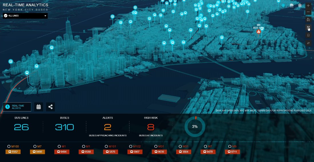
Amazing #NYC #traffic demo w/ #ArcGIS Velocity by @SpatialAgent, @EsriUC 2022 Plenary #IoT #RealTime #BigData #spatial #analysis #analytics #CIO #CTO #GIO #IT #tech #business #intelligence #GIS #esri @Esri @EsriFederalGovt @EsriSLGov @EsriBizTeam @EsriTransport @ArcGISanalysis


Never ❤️🙏


View new #ArcGIS training and #certification opportunities⬇

Do you need to ensure the accuracy of your authoritative #GIS database? Are you looking to build the skills required to share actionable insight with decision-makers? If either of these scenarios speaks to you, check out new courses from @EsriTraining: ow.ly/Ej7H50Fm6VK
esri.com
New Training and Certification Offerings | ArcNews | Summer 2021
New learning opportunities from Esri Training include instructor-led courses on branch versioning and analysis workflows and several MOOCs.

#Mapping of #BAC #Tunisia 2021 results Explore the power of #ArcGIS #Online #applications ! lnkd.in/dcDG8RK #GIS #mapping #ArcGIS #ExperienceBuilder #StoryMaps #MapViewer #Dashboards #success @GraphtechGIS


Have 20 minutes? Watch this free video to get started with #ArcGISDashboards and learn how to configure your own: go.esri.com/dashboards-vid.


#ArcGISHub is excited to announce a redesigned approach to how it handles the content you share. Look for these enhancements: 💜 Immersive, full-screen displays (map, table, and document views) 💜New filters and smart styling options Coming soon! esri.com/arcgis-blog/pr…

The profession of #geography is at risk, even as #geographers are needed now more than ever to share what they know. That's why @theAAG has started several new initiatives to support individuals and enhance institutional resources. ow.ly/5ve450EbRH2 @garylangham

In 1 week, @esricanada webinar: @ArcGISPro - Take Desktop #GIS to the Next Frontier ow.ly/c8Dw50DWFul #ArcGISPro #spatial #analysis #GIO #esriCanada #esri #arcgis #mapping @Esri @EsriFederalGovt @EsriSLGov @ArcGISanalysis @EsriTraining @EsriLive


Check out our #EsriUC workshop "Tactical Operation Coordination with ArcGIS Mission" to see how #ArcGISMission is used to maintain situational awareness and mission coordination: ow.ly/oXw650BAu4z#sa… #security #commandcontrol @GISPublicSafety

Use #webhooks to automate workflows in #ArcGIS Field #Maps bit.ly/3vWhbGQ #automation #ArcGISAdmin #IT #CIO #CTO #GIO #govtech #esri #mobile #GIS #FieldOperations @Esri @EsriFederalGovt @EsriSLGov @ArcGISOnline @EsriWater @EsriPublicWorks @EsriGeoDev

How a geospatial nervous system could help us design a better future (Jack Dangermond | TED Salon Brightline Initiative) ted.com/talks/jack_dan… via @TEDTalks
ted.com
How a geospatial nervous system could help us design a better future
What if we could better understand the world's biggest challenges simply by looking at a map? Jack Dangermond, a pioneer in geographic information system (GIS) technology that powers the digital maps...
.@ArcGISXprise on Kubernetes coming in Q2 2021, @Esri #FedGIS Plenary #ArcGISEnterprise #ArcGISAdmin #CIO #CTO #GIO #IT #govtech #GIS #esri @EsriFederalGovt @EsriSLGov @EsriTraining @EsriPartners

#ArcGIS Dev road ahead - @Esri #FedGIS 2021 Plenary #FedUC #CIO #CTO #GIO #govtech #GIS #esri #mapping #maps @EsriFederalGovt @ArcGISOnline @ArcGISPro @ArcGISXprise @ArcGISApps @EsriGeoDev @EsriLive


Webinar announcement 📣 "Introducing the Latest Resources for Teaching Imagery & Remote Sensing" takes place on March 4th at 11 a.m. (PST) go.esri.com/imagery-rs-hig… . Learn the latest teaching materials, tools and workflows to incorporate into your courses. . @EsriLive @ArcGISApps


Ravi pour le lancement de la consultation concernant le projet de décret relatif à l'exploitation des #drones en #Tunisie. Merci de nous communiquer vos avis pour pouvoir les prendre en considération. legislation.tn/content/%D9%85…


European educators created GI Learner curriculum to fill in spatial awareness and thinking skills required by employers, connecting students to lucrative careers. ow.ly/IugG50D8zHz

ArcGIS Notebooks - Where Spatial Analysis Meets Data Science youtu.be/V736h9ANiFs via @YouTube
NEW APP #ArcGISFieldMaps permet aux utilisateurs de collecter et de modifier des données, de trouver des informations sur une carte et de signaler leurs localisations en temps réel (Dispo #iOS et #Android. #FieldMaps sur notre blog #Esri : ow.ly/y7Lr50ChPgO


United States Trends
- 1. $MAYHEM 2,533 posts
- 2. Warner Bros 149K posts
- 3. HBO Max 65K posts
- 4. #FanCashDropPromotion 2,069 posts
- 5. #NXXT_CleanEra N/A
- 6. #NXXT_AI_Energy N/A
- 7. #FridayVibes 5,327 posts
- 8. NextNRG Inc 2,373 posts
- 9. Paramount 29.7K posts
- 10. Cyclist 2,677 posts
- 11. Good Friday 63.5K posts
- 12. Ted Sarandos 5,103 posts
- 13. Jake Tapper 64.3K posts
- 14. The EU 151K posts
- 15. National Security Strategy 16K posts
- 16. SINGSA LATAI EP6 71.3K posts
- 17. #สิงสาลาตายEP6 71.4K posts
- 18. TINY CARS 2,398 posts
- 19. David Zaslav 2,527 posts
- 20. World Cup 77.9K posts


Something went wrong.
Something went wrong.