#mapviewer search results

I've just prepared a lite version of my #mapviewer built with #Construct3 and a bit of #javascript #JavaScript #JS #NodeJS #Node #Construct2 #Construct3 #gamedev #indiedev #Demo #100DaysOfCode

#SIG2020, démo de Julie Rasselet : très simple de concevoir une belle carte, claire et pertinente avec le nouveau #MapViewer, la visionneuse de carte totalement repensée d’@ArcGISOnline !

ArcGIS #MapViewer es el nuevo visor de #ArcGISOnline que proporciona una experiencia totalmente diferente. Más flexible, intuitivo y rápido. Juega con #datos temporales o haz filtrados dinámicos. Nos lo cuenta Marta Pérez García, Técnico GIS, en Esriblog. blog.esri.es/entrada-de-blo…

Turno ahora de algunas de las novedades de #ArcGISOnline con Luis Íñigo: #analisis en el nuevo #MapViewer, efectos de #visualización, capas multidimensionales... 🌍 @Esri_Spain Esri #TechDay

#SIG2020, démo de Julie Rasselet : utilisation du #MapViewer, la visionneuse de carte totalement repensée d’@ArcGISOnline !


Coining the term ✨”Cloud Cartography”✨ for the new #mapviewer visualization tools #EsriUC2023 (Also SO STOKED to finally have related record editing supported after asking for it 4 years ago)
🌍¡Te presentamos el nuevo #MapViewer para la creación de #mapas online! Sí, hemos vuelto a rediseñarlo para trabajar con nuestros #datos de forma más rápida e intuitiva. Nos lo cuenta Alba Page. #CEsri20 #DataScience #GeoDevelopers


What's the state-of-play of EU #energy infrastructure works? Check it out w/ updated #PCIList #MapViewer 👉goo.gl/41n49f #CEFenergy


DYK #EMODnet services are evolving to simplify user data discovery, access & visualisation with a common #MapViewer by end 2022? Experts are in dialogue at the #EMODnet Steering Committee open session w/ Technical WG & EC MKEG @EU_MARE @defis_eu @EUScienceInnov @EU_ENV


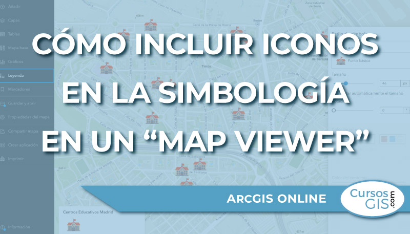
🌐💻➡️ En esta entrada se va a mostrar cómo incluir imágenes en datos de tipo punto en un visor de 𝗔𝗿𝗰𝗚𝗜𝗦 𝗼𝗻𝗹𝗶𝗻𝗲. Enlace: bit.ly/iconos_ArcGIS-… #ArcGISOnline #mapviewer #ArcGIS

💥Anoche se produjo la última actualización de #ArcGISOnline y estas son las novedades con las que ya puedes trabajar. #ArcGISDashboards #MapViewer #Apps blog.esri.es/entrada-de-blo…


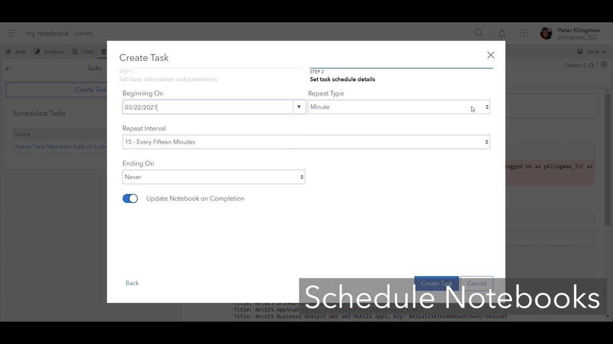
Un entrante a modo noticiero, de lo que viene en la próxima update de @ArcGISOnline en abril. Tendremos primera realease fuera de beta del nuevo #MapViewer y de #ArcGISDashboards ambos utilizando la última versión del api js, Notebooks programados..👌🏻-> youtu.be/Ngf8OmsClxc


¿Has probado ya el nuevo #MapViewer de #ArcGISOnline? Ofrece rendimiento mejorado gracias a la última versión de API JavaScript de #ArcGIS, leyenda #DotDensity, #Arcade integrado... ¡Nos lo ha mostrado Alba Page en #CEsri20!


Learn best practices on increasing collaboration & engagement w/ #ArcGISHub, mobilizing & automating your field workflows using #Survey123 & JavaScript, & preparing your agency w/ new tools like #MapViewer & #ExperienceBuilder. Register for the webinar: ow.ly/Wd6V50BFGKe


Great review of the New #MapViewer at #esriEDUC session Day 2 2021educ.hub.arcgis.com/pages/new-map-… #arcgisonline Thank you @kylie_donia @josephkerski @GIS4Teachers @GISAmbassador


Why not spend the weekend brushing up on your #mapping skills? Check out @LearnArcGIS' lesson on #MapViewer using #ArcGIS Enterprise or @ArcGISOnline Bonus? Your lesson is "on" Hawaii p.ctx.ly/r/888h

Join me @OAGEEOntarioGeo this Friday @YorkUEUC for #MapViewer Mastery! Navigate authoritative #data in #ArcGISOnline. Looking forward to presenting in person!!! #mappingfun #GIShttps://sites.google.com/view/2023oageeaegeo/home?authuser=0 @esricanada @GIS4Teachers @SIG_a_lecole

🌐💻➡️ En esta entrada se va a mostrar cómo incluir imágenes en datos de tipo punto en un visor de 𝗔𝗿𝗰𝗚𝗜𝗦 𝗼𝗻𝗹𝗶𝗻𝗲. Enlace: cursosgis.com/como-incluir-i… #ArcGISOnline #mapviewer #ArcGIS
Take your maps to the next level with #MapViewer! Join our sessions at #EsriUC2025 to learn how to create stunning, informative maps and enhance decision-making. Check out more details on Map Viewer and our sessions below 🗺️💫 Learn more ➡️ ow.ly/PTvo50WopwZ


🚀𝗔𝗿𝗰𝗚𝗜𝗦 𝗢𝗻𝗹𝗶𝗻𝗲-𝘂𝗽𝗱𝗮𝘁𝗲 𝗷𝘂𝗻𝗶 𝟮𝟬𝟮𝟱 𝗯𝗲𝘀𝗰𝗵𝗶𝗸𝗯𝗮𝗮𝗿 De update brengt krachtige verbeteringen die uw ArcGIS-ervaring naar een hoger niveau tillen. Ontdek hier de nieuwste mogelijkheden: okt.to/HYQ0ys #ArcGISOnline #MapViewer #release

🌐💻➡️ En esta entrada se va a mostrar cómo incluir imágenes en datos de tipo punto en un visor de 𝗔𝗿𝗰𝗚𝗜𝗦 𝗼𝗻𝗹𝗶𝗻𝗲. Enlace: cursosgis.com/como-incluir-i… #ArcGISOnline #mapviewer #ArcGIS

Разбрахте ли за всички полезни и вълнуващи новости, които вече са налични в Map Viewer, част от #ArcGISOnline? От по-лесно редактиране и анимирани символи до подобрени маршрути и разширени анализи, сега #MapViewer е по-мощен и интуитивен от всякога 👉 bit.ly/3DjTPUm
🌐💻➡️ En esta entrada se va a mostrar cómo incluir imágenes en datos de tipo punto en un visor de 𝗔𝗿𝗰𝗚𝗜𝗦 𝗼𝗻𝗹𝗶𝗻𝗲. Enlace: cursosgis.com/como-incluir-i… #ArcGISOnline #mapviewer #ArcGIS

Great news! #ModelBuilder (Beta) is now available in #MapViewer! Build #models that connect #analysistools and #data together. Read more about the update in the #ArcGIS blog post. Happy Modelling! #GIS #ArcGISOnline #STEAM #GISSkills #mapping esri.com/arcgis-blog/pr…

🌐💻➡️ En esta entrada se va a mostrar cómo incluir imágenes en datos de tipo punto en un visor de 𝗔𝗿𝗰𝗚𝗜𝗦 𝗼𝗻𝗹𝗶𝗻𝗲. Enlace: bit.ly/iconos_ArcGIS-… #ArcGISOnline #mapviewer #ArcGIS
🌐💻➡️ En esta entrada se va a mostrar cómo incluir imágenes en datos de tipo punto en un visor de 𝗔𝗿𝗰𝗚𝗜𝗦 𝗼𝗻𝗹𝗶𝗻𝗲. Enlace: cursosgis.com/como-incluir-i… #ArcGISOnline #mapviewer #ArcGIS


🚗 🗺️ Use the Network Analyst 𝘳𝘰𝘶𝘵𝘦 𝘴𝘰𝘭𝘷𝘦𝘳 to calculate the travel time or distance between origin/destination pairs across Esri products: #MapViewer, #ArcGISPro, #REST, & #Python API. ow.ly/M7XL50T6iu0


🚗 🗺️ Use the Network Analyst 𝘳𝘰𝘶𝘵𝘦 𝘴𝘰𝘭𝘷𝘦𝘳 to calculate the travel time or distance between origin/destination pairs across Esri products: #MapViewer, #ArcGISPro, #REST, & #Python API. ow.ly/J5CO50T4pgb


Saviez-vous qu'il était possible de publier un #Notebook en tant qu'outil web sur votre plateforme #ArcGIS afin de l'utiliser dans des applications comme le #MapViewer ou #ExperienceBuilder ? Apprenez comment faire dans #tutoriel : codethemap.fr/2024/08/api-py… @Esri_France


In this webinar, we will cover the basic tools in Map Viewer and app builders as well as some of the more advanced tools available with the new ArcGIS Web Editor. @esriuk #SweetForArcGIS #MapViewer #ArcGIS #WebEditor esri.social/QKkM50SPZK5

🎓 Learn to track temporal data in ArcGIS. Follow along and learn to configure temporal data in this public dataset from Boston bike rideshare BlueBikes using ArcGIS Expression Builder, #Arcade, #ArcGISPro, and #MapViewer. ow.ly/liSk50SSAAi

🌐💻➡️ En esta entrada se va a mostrar cómo incluir imágenes en datos de tipo punto en un visor de 𝗔𝗿𝗰𝗚𝗜𝗦 𝗼𝗻𝗹𝗶𝗻𝗲. Enlace: cursosgis.com/como-incluir-i… #ArcGISOnline #mapviewer #ArcGIS

🌐💻➡️ En esta entrada se va a mostrar cómo incluir imágenes en datos de tipo punto en un visor de 𝗔𝗿𝗰𝗚𝗜𝗦 𝗼𝗻𝗹𝗶𝗻𝗲. Enlace: bit.ly/iconos_ArcGIS-… #ArcGISOnline #mapviewer #ArcGIS

Turno ahora de algunas de las novedades de #ArcGISOnline con Luis Íñigo: #analisis en el nuevo #MapViewer, efectos de #visualización, capas multidimensionales... 🌍 @Esri_Spain Esri #TechDay

Estan geniales las nuevas guias al momento de editar en #mapviewer de #ArcGIS Online? Cómo las estas utilizando?
ArcGIS #MapViewer es el nuevo visor de #ArcGISOnline que proporciona una experiencia totalmente diferente. Más flexible, intuitivo y rápido. Juega con #datos temporales o haz filtrados dinámicos. Nos lo cuenta Marta Pérez García, Técnico GIS, en Esriblog. blog.esri.es/entrada-de-blo…


JAVA ?? You can install OC4J 10.1.3.5 on Win7 & JDK6_48 and then Oracle #MapViewer 11.1.1.6 (Feb. 2012!) and it works always fine ! Thanks.

#SIG2020, démo de Julie Rasselet : très simple de concevoir une belle carte, claire et pertinente avec le nouveau #MapViewer, la visionneuse de carte totalement repensée d’@ArcGISOnline !
Coining the term ✨”Cloud Cartography”✨ for the new #mapviewer visualization tools #EsriUC2023 (Also SO STOKED to finally have related record editing supported after asking for it 4 years ago)
I've just prepared a lite version of my #mapviewer built with #Construct3 and a bit of #javascript #JavaScript #JS #NodeJS #Node #Construct2 #Construct3 #gamedev #indiedev #Demo #100DaysOfCode
#SIG2020, démo de Julie Rasselet : utilisation du #MapViewer, la visionneuse de carte totalement repensée d’@ArcGISOnline !
🌐💻➡️ En esta entrada se va a mostrar cómo incluir imágenes en datos de tipo punto en un visor de 𝗔𝗿𝗰𝗚𝗜𝗦 𝗼𝗻𝗹𝗶𝗻𝗲. Enlace: bit.ly/iconos_ArcGIS-… #ArcGISOnline #mapviewer #ArcGIS
¿Has probado ya el nuevo #MapViewer de #ArcGISOnline? Ofrece rendimiento mejorado gracias a la última versión de API JavaScript de #ArcGIS, leyenda #DotDensity, #Arcade integrado... ¡Nos lo ha mostrado Alba Page en #CEsri20!
Great review of the New #MapViewer at #esriEDUC session Day 2 2021educ.hub.arcgis.com/pages/new-map-… #arcgisonline Thank you @kylie_donia @josephkerski @GIS4Teachers @GISAmbassador
🌍¡Te presentamos el nuevo #MapViewer para la creación de #mapas online! Sí, hemos vuelto a rediseñarlo para trabajar con nuestros #datos de forma más rápida e intuitiva. Nos lo cuenta Alba Page. #CEsri20 #DataScience #GeoDevelopers
💥Anoche se produjo la última actualización de #ArcGISOnline y estas son las novedades con las que ya puedes trabajar. #ArcGISDashboards #MapViewer #Apps blog.esri.es/entrada-de-blo…
NEW #ProfessionalDevelopment for #K12 educators! Join us as we dive into the new @ArcGISOnline #MapViewer and learn how to complete common #GIS tasks! Perfect for new users or those who need a refresher! REGISTER: arcg.is/15CHWf0


Navigate, measure, sketch, explore layers, and interrogate data in this new, multimedia StoryMap introducing Map Viewer. esriurl.com/ago5x5sm #arcgis @GISEd #mapviewer #storymap


New version! Irimap might be temporary unavailable today from 10:00 to 12:00. #WMS #mapviewer #OGC #MapServer #ClimateAction

Why not spend the weekend brushing up on your #mapping skills? Check out @LearnArcGIS' lesson on #MapViewer using #ArcGIS Enterprise or @ArcGISOnline Bonus? Your lesson is "on" Hawaii p.ctx.ly/r/888h
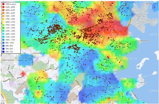
Ayer os contábamos las novedades de #MapViewer, pero ¿tienes localizadas sus casi 400 rampas de color? #dataviz #mapas #datos esri.com/arcgis-blog/pr…

Something went wrong.
Something went wrong.
United States Trends
- 1. Yamamoto 41.5K posts
- 2. #DWTS 40.5K posts
- 3. Brewers 41.1K posts
- 4. Ohtani 13.7K posts
- 5. #Dodgers 15.8K posts
- 6. #TexasHockey 2,806 posts
- 7. #DWCS 7,653 posts
- 8. #WWENXT 18.5K posts
- 9. Young Republicans 65.4K posts
- 10. Jared Butler N/A
- 11. Robert 106K posts
- 12. Haji Wright 1,105 posts
- 13. Carrie Ann 4,747 posts
- 14. Roldan 2,590 posts
- 15. Shohei 8,722 posts
- 16. Domain For Sale 9,860 posts
- 17. Politico 291K posts
- 18. Elaine 62.9K posts
- 19. Will Richard 2,551 posts
- 20. Whitney 15.7K posts