
PixElement
@PixElementTech
PixElement's patented algorithms convert aerial images from drones, planes, or satellites into precise 3D models.
Coming November 2025 — FastDraft connects your photogrammetry projects to professional 2D & 3D drafting services for fast, precise linework. Built for teams who need structure and results. Your first Work Order is FREE. #FastDraft #Photogrammetry #Mapping #3DModeling #Linework

Introducing PixElement's new and updated Generate TIN tool. 🔹Surface Model for full site detail. 🔹Bare Earth for clean topo. 🔹From Features for precise design. pixelement.com/blog/_site/202… #AerialPhotogrammetry #Surveying #ConstructionTech #GIS #PixElement
pixelement.com
Generate TIN Tool and Smarter Terrain Editing
Major updates to the TIN workflow now give users greater flexibility in creating, editing, and analyzing terrain models…
Showcase your brand on every report. Now you can easily add your own logo to PixElement's Polygon and Volume Reports, giving your deliverables a polished, professonal look that reflects your company. #AerialMapping #DroneSurveying #Photogrammetry #Volumetrics #Reporting
PixElement 2.5.0 is live. This release delivers new feature support, faster performance, and fixes that make your workflows more reliable than ever. Upgrade now to take advantage of the improvements. #PixElement #Update #ReleaseNotes #AerialMapping #Software

Check out our new tutorial on PixElement’s Stereo Reconstruction Tool, manually inspect & model structures from overlapping images for sharper results. Read/Watch: pixelement.com/blog/_site/202… #AerialPhotogrammetry #DroneMapping #3DModeling #PixElement #StereoReconstruction

This PixStory features the #archaeological site of #Iximché, Guatemala. Captured by Aerial Image Solutions & processed with PixElement, the dataset provides 3D models for #culturalheritage. #dronemapping #aerialphotogrammetry #mayanculture pixelement.com/blog/_site/202…

Edit orthos directly in your browser. Remove vehicles, shadows, or other unwanted features with PixElement’s new Orthoimage Editing Tool. No external software needed. #Photogrammetry #GIS #PixElement #MappingTools #OrthoimageEditing pixelement.com/blog/_site/202…

New in PixElement: Add annotations directly to your 2D/3D scenes. Label features, set elevations, and export to various formats. Clarity + collaboration built in. 🔗 pixelement.com/blog/_site/202… #GISWorkflows #3DMapping #GeospatialTools #Photogrammetry

New at PixElement: export your polygon measurements as clean, shareable PDFs. Area, perimeter, coordinates, map previews — all in one report. #DroneMapping #Surveying #Photogrammetry #PixElement pixelement.com/blog/_site/202…

PixElement 2.4.1 - Now Deployed. This update focuses on stability, performance, and expanded reporting options, built to support high-demand mapping workflows from field to finish. #Photogrammetry #Geospatial #SurveyTech #PixElement #3DMapping #AerialSurvey #Update

Happy 4th of July from the PixElement team 🇺🇸 Today we honor the courage behind our independence, and those who continue to defend it. We build geospatial tools for the mission. We build for you. #4thOfJuly #MissionReady #DefenseMapping #BlueUAS #MadeInUSA

Photogrammetry isn’t just data, it’s documentation, storytelling, and insight. #PixStories is a new series on how users apply PixElement in the field. 📖 Read more: pixelement.com/blog/_site/202… 📤 Got a project? Submit it via the blog. #PixElement #PixStories #DroneMapping

New in PixElement: denser point clouds, bare earth extraction from LiDAR, better processing feedback, and more. Built for real-world mapping workflows, on both cloud and desktop. Read the full breakdown: pixelement.com/blog/_site/202… #Photogrammetry #Geospatial #LiDAR #Software

🆕 Now live in PixElement Cloud: the Translator Tool 🌍 Edit translations right inside the app—no more file swapping. Ideal for quick fixes or full language updates. pixelement.com/blog/_site/202… #PixElement #Localization #Photogrammetry #Translation #Tool #GeospatialTech

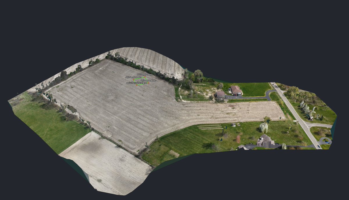
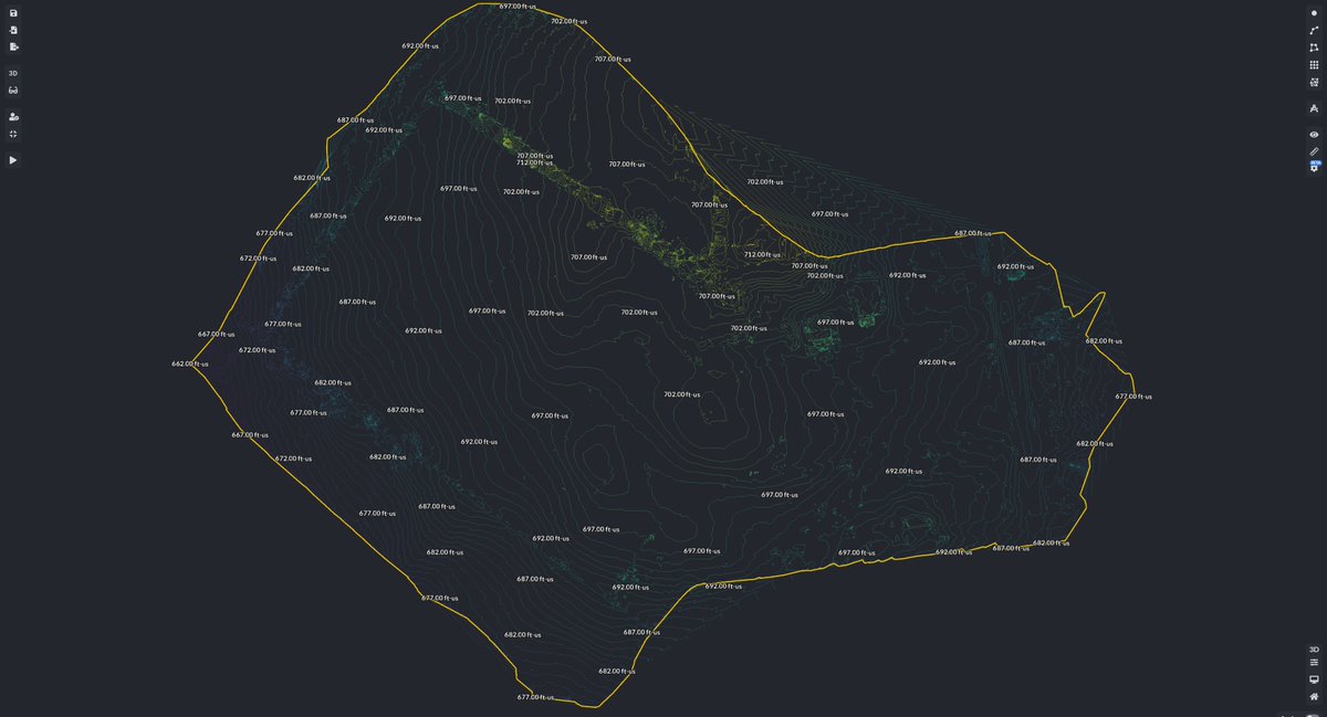
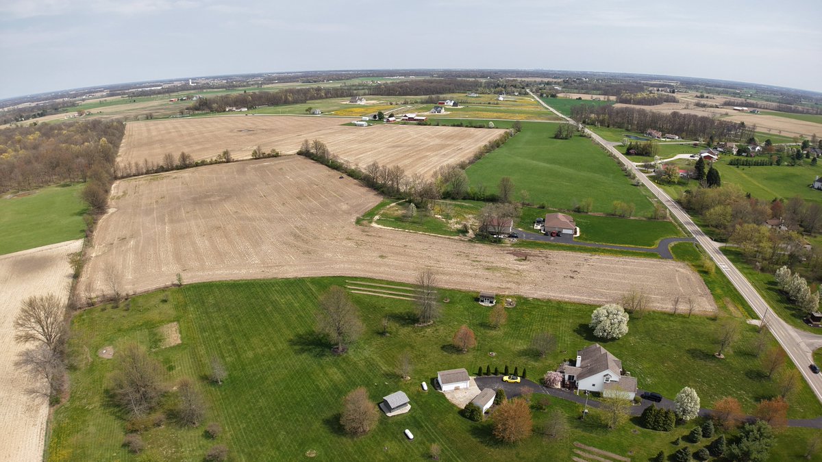
From field to foundation 🏡📍 We used PixElement to map this future homesite in Marysville, OH: ✅ Orthomosaic ✅ Elevation contours ✅ Soil sample & house layout overlay Smarter planning starts with better data. #DroneMapping #SitePlanning #PixElement
The PixElement desktop version is here—giving you full local processing power for both imagery & LiDAR. Explore our Basic & Advanced packages and see which workflow fits you best. #Photogrammetry #LiDARProcessing #DroneMapping #Surveying #GeospatialTools pixelement.com/blog/_site/202…

Our new #VolumeReport tool makes it easy to export a PDF summary of your measured volumes, including cut & fill calculations, surface areas, and project metadata. #AerialPhotogrammetry #PixElement #StockpileManagement #Surveying pixelement.com/blog/_site/202…

Analyze elevation & grading changes with precision—perfect for water flow management, construction planning, & terrain assessment with Profile Viewer. pixelement.com/blog/_site/202… #PixElement #Surveying #DroneMapping #ElevationAnalysis #3DMapping #CivilEngineering #LandSurveying

Oblique & orbit imagery are key to accurate #3D reconstructions—especially for vertical structures. Refine your #photogrammetry workflow with best practices in our latest article. pixelement.com/blog/_site/202… #3DModeling #DroneMapping #ObliqueImagery #BestPractices #Drones
pixelement.com
3D Modeling with Aerial Photogrammetry: Oblique and Orbit Imagery
In this article, we will be looking at 3D modeling with aerial photogrammetry using oblique and orbit imagery.
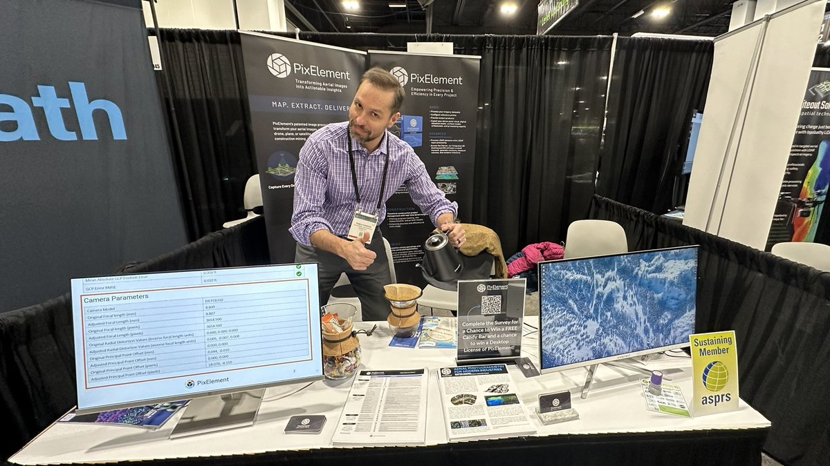
☕️ We are grinding at GeoWeek! ☕️ Stop by the PixElement booth (#1043) for a free cup of coffee and a chat about aerial photogrammetry. A special thanks to Pablo Fuentes at Makepath for modeling. #GeoWeek #PixElement #Aerialphotogrammetry #Denver


United States Trends
- 1. Marshawn Kneeland 39.7K posts
- 2. Nancy Pelosi 54.7K posts
- 3. Craig Stammen 1,473 posts
- 4. Gordon Findlay 1,041 posts
- 5. #MichaelMovie 58.8K posts
- 6. Pujols N/A
- 7. Ozempic 4,452 posts
- 8. #NO1ShinesLikeHongjoong 35.5K posts
- 9. #영원한_넘버원캡틴쭝_생일 34.9K posts
- 10. Eli Lilly 3,193 posts
- 11. Abraham Accords 2,606 posts
- 12. Baxcalibur 5,587 posts
- 13. GLP-1 3,674 posts
- 14. Gremlins 3 4,513 posts
- 15. Chimecho 8,242 posts
- 16. ESPN Bet 3,040 posts
- 17. Preller N/A
- 18. Dallas Cowboys 14.2K posts
- 19. Joe Dante N/A
- 20. #Ask4Help N/A
Something went wrong.
Something went wrong.