
You might like


I was honored to deliver the opening talk at the @GISRUK conference hosted by the @UniversityLeeds, sharing insights of the great work that we at @WorldPopProject at @UoSGeogEnv do and encouraging excellent discussions among fellow GIS enthusiasts.


#30DayMapChallenge Day 27: Dot Last week we released an experimental tool for visualising flow data (or "origin-destination" data) by animating 200,000+ dots on a map. To celebrate "Dot day", we're releasing all of the code (See 🧵). #gischat ons.gov.uk/visualisations… 1/5
🗺️📊🚨New snazzy interactive tool for #geography and #stats nerds! Explore #Census2021 flows data. See where people lived and worked, and where they moved to/from in the year before census (**see data caveats in 🧵**) ons.gov.uk/visualisations… #geographyteacher #gischat 1/

A very annoying 'what is this showing?' map of Greater London for today's #30DayMapChallenge


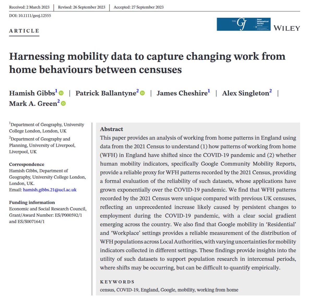
📰WORKING FROM HOME & MOBILITY DATA📰Wondering how working from home has transformed in your area? Or whether mobility data can truly replace the census? This is the paper for you 👇New paper in @geogjournal w/ Hamish Gibbs, @spatialanalysis, @alexsingleton and @markalangreen👥

🔉New paper published in #GJ by @kuba_wyszo, Paul A. Longley, Alex D. Singleton, Christopher Gale, and @oobr. 'A neighbourhood Output Area Classification from the 2021 and 2022 UK censuses'. #OpenAccess doi.org/10.1111/geoj.1…


Such an inspiring talk by @datasew at @GIScience_conf 2023 about using data for a public good! 👏🏻😊 🌍 #GIScience


📢 New paper out 📊🤖🌆💡 S De Sabbata @maps4thought, A Ballatore, P Liu and NJ Tate (2023) Learning urban form through unsupervised graph-convolutional neural networks. Workshop on Geospatial Knowledge Graphs and GeoAI #urbananalytics #neuralnetworks aballatore.space/2023/09/14/com…


Spent the last couple of days in awe at #GIScience2023 enjoying everybody's incredible work. Thanks a lot to the organisers @GIScience_conf for putting everything together and big shout-out to the workshop leaders for their hard work!! (Amazing campus, btw!)

Such a poignent start to #GiScience2023 main conference session day1. Today’s Keynote speakers @j_p_albuquerque & @kabariac shedding some light into urban inequalities and participatory GIS for mapping slums. A pathway to equity for slum communities perhaps? @IDEAMAPSNetwork

Nice wrapup to workshop day at #GiScience2023! Thanks @Josh_A_Redmond for a great workshop on WebApps for #Python and #R!


What qualifications do people in your town leave with, and how does that compare? Find out with this tool... ons.gov.uk/peoplepopulati…

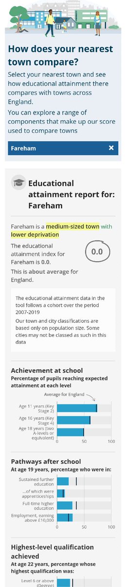

Use our new interactive tool in the article to see how educational attainment compares in your nearest town with other towns across England. 🔎 ons.gov.uk/peoplepopulati…


As promised, today's map is an improved version of the #Badmap. Raw counts have been replaced by population density while there is a modest number of categories in the key and a better colour scheme #30DayMapChallenge #Day30 #Remix. Data available here: ons.gov.uk/peoplepopulati…

Geographies in UK change over time. Most analysts have stumbled across this by accident when joining data to boundaries and finding some NULLs... so here we present Local Authority District NULLs since 2019. #30DayMapChallenge #Day22 #NULL

The number of visits abroad plummeted from 2019 highs to 2020 lows for UK residents to other countries in Europe amid Covid-19 international travel restrictions #30DayMapChallenge #Day23 #MovementMap

The physical web of transit connections! These are the median distances to transit connections across 2021 Output Areas in England and Wales, and shows how connectivity between areas can vary across the countries #30DayMapChallenge #Networks #QGIS

The administrative geography of Britain is complex and subject to change through time. In 1921 there were 1,827 districts in England and Wales comprised of Counties, Boroughs, Urban, Rural and Metropolitan Districts, plus the City of London #30DayMapChallenge #Polygons #ArcMap

With a new census comes new population-weighted centroids! These are the five Output Areas with the largest distance moved between 2011 and 2021 centroids. Check out the latest centroids here: geoportal.statistics.gov.uk/search?collect…) #30DayMapChallenge #Points #QGIS

Proposed release dates for Census boundaries on portal: OA_BFE 5th Aug OA_BFC be 11th Aug LSOA_BFE 11th Aug MSOA_BFE 11th Aug LSOA_BFC 19th Aug MSOA_BFC 19th Aug OA_BGC 9th Sep LSOA_BGC 14th Sep MSOA_BGC 14th Sep LSOA_BSC 28th Sep MSOA_BSC 28th Sep geoportal.statistics.gov.uk
#30DayMapChallenge Day 30: #Metamapping day - We hope you've enjoyed our #maps for the past month! We've compiled them all together on our Github repo if you want to revisit any! github.com/ONSgeo/ONS_30D…


United States Trends
- 1. Marshawn Kneeland 22.6K posts
- 2. Nancy Pelosi 27.6K posts
- 3. #MichaelMovie 37.4K posts
- 4. #NO1ShinesLikeHongjoong 27.8K posts
- 5. #영원한_넘버원캡틴쭝_생일 27.7K posts
- 6. ESPN Bet 2,372 posts
- 7. Gremlins 3 3,044 posts
- 8. Madam Speaker 1,164 posts
- 9. Baxcalibur 3,814 posts
- 10. #thursdayvibes 3,032 posts
- 11. Chimecho 5,574 posts
- 12. Joe Dante N/A
- 13. Jaafar 11.3K posts
- 14. Chris Columbus 2,726 posts
- 15. Good Thursday 36.6K posts
- 16. #BrightStar_THE8Day 41.8K posts
- 17. Votar No 27.1K posts
- 18. Diantha 1,597 posts
- 19. Penn 9,364 posts
- 20. Korrina 4,523 posts
You might like

Something went wrong.
Something went wrong.