
TurfJS
@turfjs
Advanced geospatial analysis for browsers and Node.js. Support the project on https://opencollective.com/turf 🙏
You might like


Turf just released the long awaited v7! Loads of bug fixes, type improvements and features added in this release 🎉


Love that the @turfjs implementation for measuring Polygon area on the Earths surface come from a NASA Jet Propulsion Laboratory publication dataverse.jpl.nasa.gov/dataset.xhtml?…


Built with @Mapbox, @vite_js, @reactjs, @fontawesome, @tailwindcss. Data processing with @turfjs, and R (gtfsrouter package). Deployed on @Netlify. Code on @github.
Inspired by the rapid-fire experience of chronotrains.com, I built a similar interactive that shows how far you can get from each NYC subway station in 40 minutes. Have a look at subwaysheds.com 👀

I love how easy it is to use JS libraries with @FableCompiler To use @turfjs I just need to specify which functions I need and what types I do expect #fsharp


10-20-30-40 minute isochrones for subway + walking(ish) from Atlantic Ave/Barclays Center. This is a @turfjs -intensive workflow, using buffer, dissolve, truncate, and intersect. Now to make them for the other 471 stations. cc/ @_benjamintd


After a bit of work the Turf.js docs should now be responsive and be an all round nicer experience on mobile/tablet than they were before! turfjs.org


This Pi Day, don't worry about using pi to calculate area - use Mapbox GL JS and @turfjs! This example from our Docs shows how to calculate the area of any mapped polygon. See it in action: buff.ly/3kXuCG8 #PiDay #gischat


A "new" way to find locations on a map, powered by @Mapbox & @turfjs. Search for a geolocation, change the center marker & drag to resize the radius zone. Pairs with @thatsfinsweet Attributes to update a filterable list. Coming soon!


Make your web maps look more like print – by overlapping a hidden symbol layer along a map edge you can avoid labels being clipped with @Mapbox and @turfjs. Play with it here: willymaps.github.io/labelclip/

I just discovered @turfjs, Why have i been doing manual distance, mid Points and bearing calculations ?

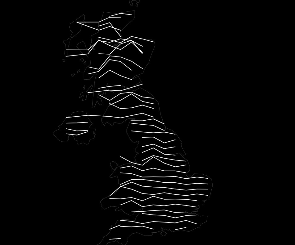
Thanks to @willy_maps idea and code, and a bit of help from @en_dash, I have now made a totally essential spidermap of trig pillars across Great Britain - shows the 8 closest trig pillars to the centre of the screen alasdairrae.github.io/trigpillars/

Another day, another #dataviz. This time, Joy Division-style ridgeline map with altitudes on @observablehq with the help of d3 and @turfjs. #observable #datavisualization observablehq.com/@dmylian/mappi… 🇺🇦


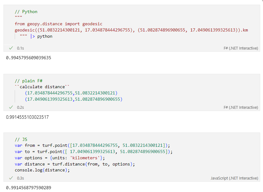
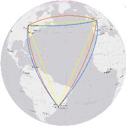
Calculating distance between 2 points in one notebook #fsharp, #javascript (with @turfjs ), #python (with geopy via @pyodide)

#30DayMapChallenge (late) Day 8 - Blue This map shows each European country's surface water area. The Netherlands has the highest percentage, with 10.35% of its area covered by water


Thanks to @turfjs for a powerful spatial analysis toolbox to enable this project.
I have open sourced code used to calculate walk potential for cities. Some assembly required. gitlab.com/markstos/walk-… Here's an example use contrasting walk potential (green) with missing sidewalks (red). @samth

I just published in @JS_PlainEnglish A Neat Trick to Merge Adjacent Polygons in Spatial Datasets with Turf.js javascript.plainenglish.io/a-neat-trick-t… #geospatial #ools #DataAnalytics
javascript.plainenglish.io
A Neat Trick to Merge Adjacent Polygons in Spatial Datasets with Turf.js
Use-Case + Code Implementation. Tool available at my GitHub.

Video: "@FOSS4G - Browser-side geoprocessing with Turf.js and #Leaflet" youtube.com/watch?v=mS-o7U…
youtube.com
YouTube
FOSS4G - Browser-side geoprocessing with Turf.js and Leaflet


United States Trends
- 1. Caleb Wilson 1,139 posts
- 2. Bryson Tiller 3,337 posts
- 3. Darryn Peterson 1,313 posts
- 4. Kansas 21.7K posts
- 5. Vesia 4,603 posts
- 6. Grammy 467K posts
- 7. Dizzy 11.5K posts
- 8. Sam Merrill N/A
- 9. End of 1 18.4K posts
- 10. Georgetown 2,580 posts
- 11. #FliffCashFriday 2,523 posts
- 12. Keldon Johnson N/A
- 13. #kubball N/A
- 14. #YIAYbeast N/A
- 15. #drwfirstgoal N/A
- 16. End 1Q N/A
- 17. James Watson 14.2K posts
- 18. NBA Cup 6,266 posts
- 19. Noah Clowney N/A
- 20. End of the 1st 1,005 posts
You might like


Something went wrong.
Something went wrong.