#digitalterrainmodel search results

#ATDI #DigitalTerrainModel New Free high resolution #cartography #Download #NewBrunswick #Southampton #Dublin #Cairo #Ukraine #Moldova #Montenegro #Hawarden #UnitedKingdom #BOURNEMOUTH #CoventryCity #Cumbernauld #Wroclaw #Cambridge #Newcastle #Farnborough #Luxemburg #Jacksonville


Accuracy Assessment of #DigitalTerrainModel Dataset Sources for #Hydrogeomorphological Modelling in Small #Mediterranean #Catchments by Graf, L.; Moreno-de-las-Heras, M.; et al. 2019 👉mdpi.com/379928 #DEM

#ATDI #DigitalTerrainModel: #LosAngeles 2 m - #lidar Terrain+Clutter+Buildings 2021 Free #cartography #Download #HTZ


#ATDI #DigitalTerrainModel New Free high resolution #cartography #Download: #Denver #CincinnatiAirport #Charlottesville #Palmbeach #Sunderland #Pruszkow #Djibouti #Wielun #Opole #Swidnica #Nysa #Togo #Congo #Skierniewice #LaReunion #Paraguay #Montevideo #Krakow #Lodz #Warsaw

@ATDI #DigitalTerrainModel: Spain at 20 m resolution #Elevation+#Clutter 2018 Free #maps download atdi.com/cartography (includes Portugal)


@ATDI #DigitalTerrainModel: #Vietnam and #Cambodgia at 20 m resolution #Elevation+#Clutter 2018 Free #maps download atdi.com/cartography


Goddard’s #LiDAR, Hyperspectral and Thermal Imager (#GLiHT) #DigitalTerrainModel data products are now available. These data provide bare earth elevation at 1 m spatial resolution over ecoregions in North America. Visit NASA’s #LPDAAC to learn more. bit.ly/3ynHU09

#ATDI #DigitalTerrainModel New Free high resolution data #cartography #Download: #Hibaldstow #Norwich #LondonSouthendAirport #Oxford #Exeter #EastMidlandsAirport #CentralAfrica


The @Xsurv_Tx CAD techs coming through. Nice looking digital terrain model! #DigitalTerrainModel #DTM #Trimble #TrimbleBusinessCenter #CAD #TIN #Earthwork #Construction #SiteModel #CommercialConstruction #TexasConstruction


RT @ATDI: #ATDI #DigitalTerrainModel New Free high resolution #cartography #Download: #Denver #CincinnatiAirport #Charlottesville #Palmbeach #Sunderland #Pruszkow #Djibouti #Wielun #Opole #Swidnica #Nysa #Togo #Congo #Skierniewice #LaReunion #Paraguay #M…

Many students ask the difference, so here you go. . . #digitalsurfacemodel #digitalterrainmodel #canopyheightmodel

#ATDI #DigitalTerrainModel: #GIS data #Freedownload #map #faroeIsland - #lidar Terrain+Clutter+Buildings 2021 Free #cartography #Download #HTZ


Our experts @bluecloudEU demonstrate #EMODnet products 4 users #Bathymetry #DigitalTerrainModel, #Chemistry #contaminants maps 4 #MSFD + #Biology copepod time-series product 4 @ICES_ASC : added value of interoperable standardized #marinedata + metadata, a backbone 4 #bluecloudEU


#ATDI #DigitalTerrainModel #Switzerland + #Liechtenstein high resolution dataset now available #HTZ software

#ATDI #DigitalTerrainModel: #Cracow 1 m - Poland 1 m DTM+Clutter+Buildings+Vegetation 2020 Free #maps download #HTZ


Accuracy of Ground Surface Interpolation from Airborne Laser Scanning (#ALS) Data in Dense Forest Cover by Mihnea Cățeanu, Arcadie Ciubotaru 👉 mdpi.com/2220-9964/9/4/… #airbornelaserscanning #digitalterrainmodel #surfaceinterpolation #LiDAR

#ATDI #DigitalTerrainModel: #GIS data #Freemapdownload #map Riga #Latvia 1 m - #lidar Terrain+Clutter+Buildings 2021 Free #cartography #HTZ


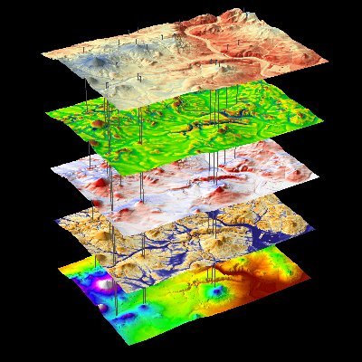
Debris Flows Keep the Landscape on the Straight and Narrow #satellitedata #digitalterrainmodel #debrisflow eos.org/editor-highlig…


Cotton Reserve — GA, 13.5 Acres, 24 Hours from CAD to Deliverable! letelmetrics.com/service/digita… #digitalterrainmodel #planimetricsurvey #planimetricmappingservice #lidarmappingservices #lidarservices #planimetricdrawing #planimetricasbuilt #lidarmapping #dronesurveyors


🏔️ Are you making the most out of Global Mapper? Learn how to create Digital Terrain Models in Global Mapper Pro: ow.ly/RTeo50Rijyt #GlobalMapper #DigitalTerrainModel #DTM #ElevationGrid #TerrainAnalysis

🏔️ Are you making the most out of Global Mapper? Learn how to create Digital Terrain Models in Global Mapper Pro: ow.ly/RTeo50Rijyt #GlobalMapper #DigitalTerrainModel #DTM #ElevationGrid #TerrainAnalysis

The @Xsurv_Tx CAD techs coming through. Nice looking digital terrain model! #DigitalTerrainModel #DTM #Trimble #TrimbleBusinessCenter #CAD #TIN #Earthwork #Construction #SiteModel #CommercialConstruction #TexasConstruction

Join our webinar on "Working with SRTM/ASTER DEM data for #digitalterrainmodel generation using #AutoPlotter" on April 13, 2023. Learn to download SRTM/ASTER data, import into AutoPlotter, & generate DTM for planning purposes. Register zurl.co/18EN now! #landsurveying

Debris Flows Keep the Landscape on the Straight and Narrow #satellitedata #digitalterrainmodel #debrisflow eos.org/editor-highlig…
New global #DigitalTerrainModel with 30 m resolution. Based on Copernicus DEM with #GEDI and #ICESat-2 #lidar used for #forest height and building removal. Congratulation @laurence_hawker et al. ! Accompanying paper: iopscience.iop.org/article/10.108…
Many students ask the difference, so here you go. . . #digitalsurfacemodel #digitalterrainmodel #canopyheightmodel
#ATDI #DigitalTerrainModel: #GIS data #Freedownload #map #faroeIsland - #lidar Terrain+Clutter+Buildings 2021 Free #cartography #Download #HTZ
#ATDI #DigitalTerrainModel: #GIS data #Freedownload #map #Rotterdam 1 m - #lidar Terrain+Clutter+Buildings 2021 Free #cartography #Download #HTZ

Accuracy Assessment of #DigitalTerrainModel Dataset Sources for #Hydrogeomorphological Modelling in Small #Mediterranean #Catchments by Graf, L.; Moreno-de-las-Heras, M.; et al. 2019 👉mdpi.com/379928 #DEM
#ATDI #DigitalTerrainModel New Free high resolution #cartography #Download #NewBrunswick #Southampton #Dublin #Cairo #Ukraine #Moldova #Montenegro #Hawarden #UnitedKingdom #BOURNEMOUTH #CoventryCity #Cumbernauld #Wroclaw #Cambridge #Newcastle #Farnborough #Luxemburg #Jacksonville
Our experts @bluecloudEU demonstrate #EMODnet products 4 users #Bathymetry #DigitalTerrainModel, #Chemistry #contaminants maps 4 #MSFD + #Biology copepod time-series product 4 @ICES_ASC : added value of interoperable standardized #marinedata + metadata, a backbone 4 #bluecloudEU
RT @ATDI: #ATDI #DigitalTerrainModel New Free high resolution #cartography #Download: #Denver #CincinnatiAirport #Charlottesville #Palmbeach #Sunderland #Pruszkow #Djibouti #Wielun #Opole #Swidnica #Nysa #Togo #Congo #Skierniewice #LaReunion #Paraguay #M…
Accuracy of Ground Surface Interpolation from Airborne Laser Scanning (#ALS) Data in Dense Forest Cover by Mihnea Cățeanu, Arcadie Ciubotaru 👉 mdpi.com/2220-9964/9/4/… #airbornelaserscanning #digitalterrainmodel #surfaceinterpolation #LiDAR
Creating a Lowland and #Peatland #Landscape #DigitalTerrainModel (#DTM) from Interpolated Partial Coverage #LiDAR Data for Central Kalimantan and East Sumatra, #Indonesia 📝mdpi.com/2072-4292/11/1… by Ronald Vernimmen, Aljosja Hooijer, et al.

#ATDI #DigitalTerrainModel New Free high resolution #cartography #Download: #Denver #CincinnatiAirport #Charlottesville #Palmbeach #Sunderland #Pruszkow #Djibouti #Wielun #Opole #Swidnica #Nysa #Togo #Congo #Skierniewice #LaReunion #Paraguay #Montevideo #Krakow #Lodz #Warsaw
The @Xsurv_Tx CAD techs coming through. Nice looking digital terrain model! #DigitalTerrainModel #DTM #Trimble #TrimbleBusinessCenter #CAD #TIN #Earthwork #Construction #SiteModel #CommercialConstruction #TexasConstruction
@ATDI #DigitalTerrainModel: Spain at 20 m resolution #Elevation+#Clutter 2018 Free #maps download atdi.com/cartography (includes Portugal)
#ATDI #DigitalTerrainModel: #LosAngeles 2 m - #lidar Terrain+Clutter+Buildings 2021 Free #cartography #Download #HTZ
#ATDI #DigitalTerrainModel New Free high resolution data #cartography #Download: #Hibaldstow #Norwich #LondonSouthendAirport #Oxford #Exeter #EastMidlandsAirport #CentralAfrica
#ATDI #DigitalTerrainModel: #GIS data #Freedownload #map #faroeIsland - #lidar Terrain+Clutter+Buildings 2021 Free #cartography #Download #HTZ
@ATDI #DigitalTerrainModel: Berlin (Germany) at 2 m resolution #Elevation+#Clutter+#Building 2018 Free #maps download atdi.com/cartography


@ATDI #DigitalTerrainModel: #Vietnam and #Cambodgia at 20 m resolution #Elevation+#Clutter 2018 Free #maps download atdi.com/cartography
#ATDI #DigitalTerrainModel #Switzerland + #Liechtenstein high resolution dataset now available #HTZ software
#ATDI #DigitalTerrainModel: #GIS data #Freemapdownload #map Riga #Latvia 1 m - #lidar Terrain+Clutter+Buildings 2021 Free #cartography #HTZ
#ATDI #DigitalTerrainModel: #Cracow 1 m - Poland 1 m DTM+Clutter+Buildings+Vegetation 2020 Free #maps download #HTZ
#ATDI #DigitalTerrainModel: #Amsterdam 1 m - The #Netherlands at 1 m resolution DTM+Clutter+Buildings+Vegetation height 2020 Free #maps download #HTZ

Many students ask the difference, so here you go. . . #digitalsurfacemodel #digitalterrainmodel #canopyheightmodel
Something went wrong.
Something went wrong.
United States Trends
- 1. Lakers 57.4K posts
- 2. Luka 57.4K posts
- 3. Wemby 22.4K posts
- 4. Marcus Smart 4,428 posts
- 5. #LakeShow 4,608 posts
- 6. Blazers 6,722 posts
- 7. Richard 45.1K posts
- 8. Ayton 11.3K posts
- 9. Horford 1,609 posts
- 10. Westbrook 8,825 posts
- 11. #RipCity N/A
- 12. #AEWDynamite 19.3K posts
- 13. Podz 2,255 posts
- 14. Champagnie 1,150 posts
- 15. #AmphoreusStamp 4,200 posts
- 16. Kuminga 3,142 posts
- 17. Spencer Knight N/A
- 18. Thunder 31.2K posts
- 19. #Survivor49 3,284 posts
- 20. Deni 5,986 posts