
Charles
@C4708911Charles
Exploring the world of spatial data with a passion for GIS, web development, and remote sensing. 🚀🌍 Tweeting: #Geospatial #RemoteSensing #PythonForGIS #WebDev
You might like

Primary school maps sparked a curiosity… Today, I’m turning that curiosity into meaningful geospatial insights! 🌿🛰️ #GISMapping #GrowthJourney


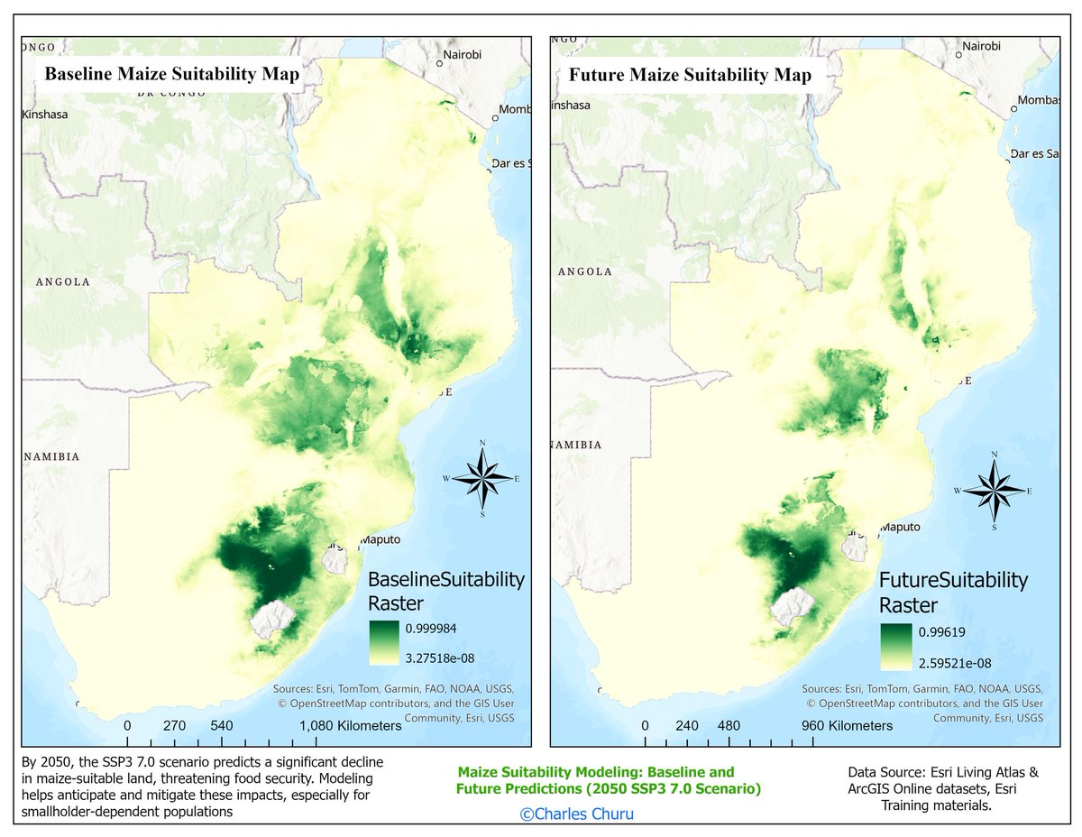
🌍🌾 Climate change is shrinking maize-suitable land in Sub-Saharan Africa by 2050 under SSP3 7.0. Using the Presence-Only Prediction (MaxEnt) tool in ArcGIS Pro, we can model and plan for future food security. #ClimateChange #FoodSecurity #GIS
🚀 Exploring Laikipia from Above! 🌍✨ Took on the challenge of mapping Laikipia County, Kenya using advanced GIS techniques! 🛰️📍 Featuring Esri 2023 Land Cover, OpenStreetMap basemap & USGS Elevation Data. What do you think? 🔍📊 #GIS #Mapping #Kenya #Geospatial

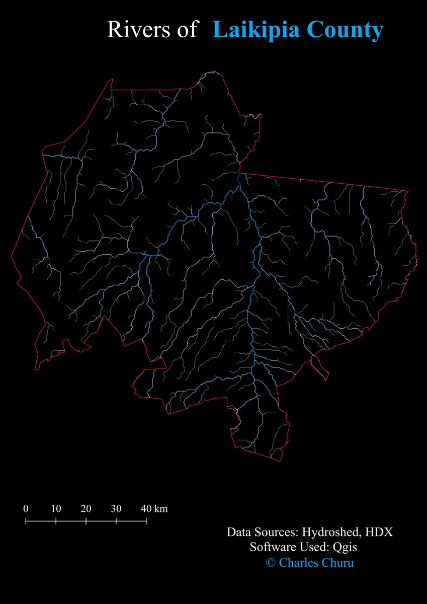
🌍🚀 Just mapped the Rivers of Laikipia County using #QGIS! 🗺️✨ Exploring the lifelines that shape the landscape—flowing through forests, farms, and communities. 🌊💚 Check it out! 👀 #GIS #Mapping #Geospatial #Laikipia
Just completed the Esri Going Places with Spatial Analysis course! Aapplying GIS concepts to real-world locations made every lesson insightful. Excited to use these skills in future projects! 🌍📊 #GIS #SpatialAnalysis #Esri
🌞 Used #ArcGISPro to analyze solar energy potential by mapping solar radiation! Identifying ideal rooftops for solar panels can help drive clean energy adoption and reduce emissions. 🌍⚡ #GIS #RemoteSensing #SolarEnergy #Sustainability #Geospatial


🌍🗺️ Leveled up to Intermediate Mapper on OSM! 🎉 Excited to keep adding roads, buildings & key features to make maps better! 🚀 Let’s keep the world mapped! 🛰️📍 #OSM #Mapping #GIS #YouthMappers


Happy Birthday QGIS, 23! geoobserver.de/2025/02/18/hap… #qgis #switsch2qgis #gistribe #gischat #fossgis #foss4g #OSGeo #spatial #geospatial #opensource #mapping #gis #geo #geoObserver pls RT @QGIS @QGISMaps

🌍📍Hydrological Analysis of Igwamiti Ward, Laikipia County 🌊🗺️ Using SRTM DEM & HDX boundaries, I analyzed flow direction, accumulation, watershed delineation & stream networks in ArcMap! 🚀🌎 #GIS #RemoteSensing #Hydrology #ArcMap #Laikipia

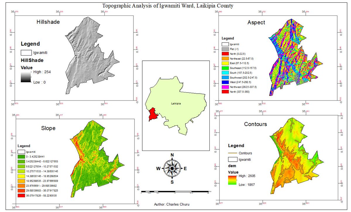
🌍📊 Conducted a topographic analysis of Igwamiti Ward, Laikipia County! Generated: ✅ Hillshade 🏔️ ✅ Contours 📏 ✅ Slope ⛰️ ✅ Aspect 🌞 GIS and remote sensing for better terrain insights! #GIS #DEM #Topography #Laikipia
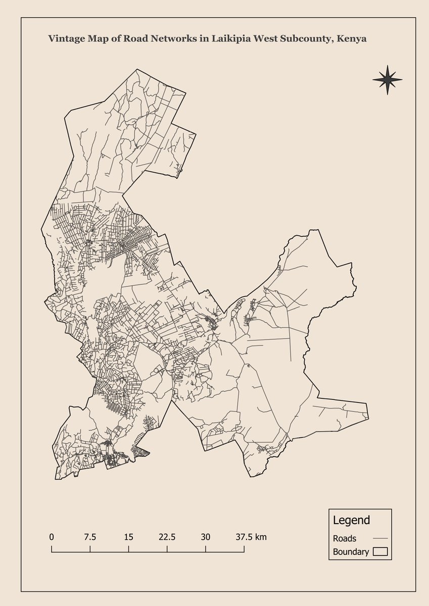
Day 7 of #30DayMapChallenge: Created a vintage-style map of the road network in Laikipia West Subcounty, Kenya! 🛣️ With muted colors and classic cartographic elements, this map blends modern data with a historical aesthetic. #GIS #Mapping #VintageMaps
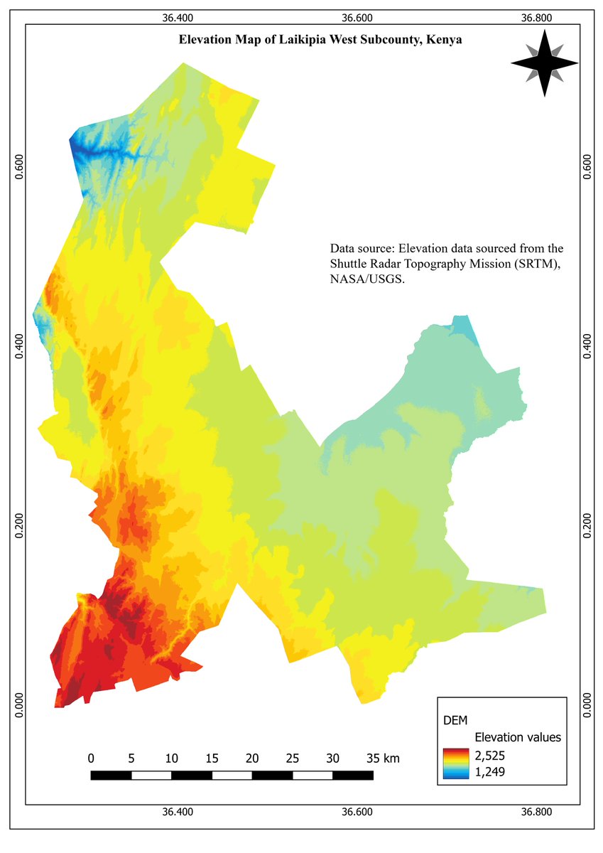
Day 6 of #30DayMapChallenge: Created an elevation map of Laikipia West Subcounty using SRTM data! 🏞️ Visualized the region’s topography from valleys to peaks. #GIS #DEM #Mapping
Day 5 of #30DayMapChallenge: Mapped a journey using #QGIS! 🚶♂️✈️ Every path tells a story. #GIS #MappingJourney
🌍 Day 4 of the #30DayMapChallenge: Created a density map using hexagonal grids in QGIS for Nyeri Town, Kenya! 📊 Hexagons bring out spatial patterns beautifully, adding depth to the data. Excited to explore more mapping techniques! #GIS #QGIS #Geospatial #Mapping #Kenya


Forget the skill-based progress in the industry. For GIS professionals, you require; - Adaptability - Creativity - Forward-thinking (Innovative capacities) These four unique stages should help you in your GIS development career.

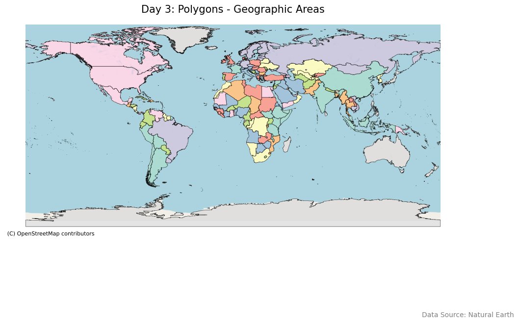
🗺️ Day 3 of the #30DayMapChallenge: Focused on polygons! I visualized various geographic areas, showcasing different countries with vibrant colors. Excited to see where this challenge takes me! 🌳🏙️✨
🚦 Day 2 of the #30DayMapChallenge: I mapped roads and railways! 🌊🚗🚆 Using different colors and styles, I highlighted these vital transportation routes on a stunning terrain background. Loving the details in the lines! 🌍✨

🌍 Day 1 of the #30DayMapChallenge: I visualized airports and populated places around the world! ✈️ Plotted them with custom styling and a beautiful terrain basemap. Excited to kick off this mapping journey! 📍✨


United States Trends
- 1. #WWERaw 60.3K posts
- 2. Purdy 25.4K posts
- 3. Panthers 34.2K posts
- 4. Bryce 18.8K posts
- 5. 49ers 36K posts
- 6. Canales 12.5K posts
- 7. Mac Jones 4,641 posts
- 8. #FTTB 5,119 posts
- 9. Penta 9,286 posts
- 10. #KeepPounding 5,160 posts
- 11. Niners 5,159 posts
- 12. Gunther 13.6K posts
- 13. Jaycee Horn 2,576 posts
- 14. #RawOnNetflix 2,025 posts
- 15. Jennings 7,683 posts
- 16. Ji'Ayir Brown 1,196 posts
- 17. Melo 18.1K posts
- 18. Rico Dowdle 1,566 posts
- 19. Moehrig N/A
- 20. #CARvsSF 1,257 posts
You might like

Something went wrong.
Something went wrong.