#arcgispro search results

Inspired by her love of geology and collecting national park postcards, Iza Ogilive created this Earth themed map using @John_M_Nelson’s Postcard style and Sentinel-2 satellite imagery in #ArcGISPro! Check out day 5 of the #30DayMapChallenge: ow.ly/Fq0y50XmPi7

These animations showcase one of the greatest dimensions of all - time! Using Black Stork observations from GBIF in #ArcGISPro, Craig McCabe compressed 17 years of GPS tracks into 1, to amplify this epic migration. #30DayMapChallenge day 6: ow.ly/JLmU50XnsSy
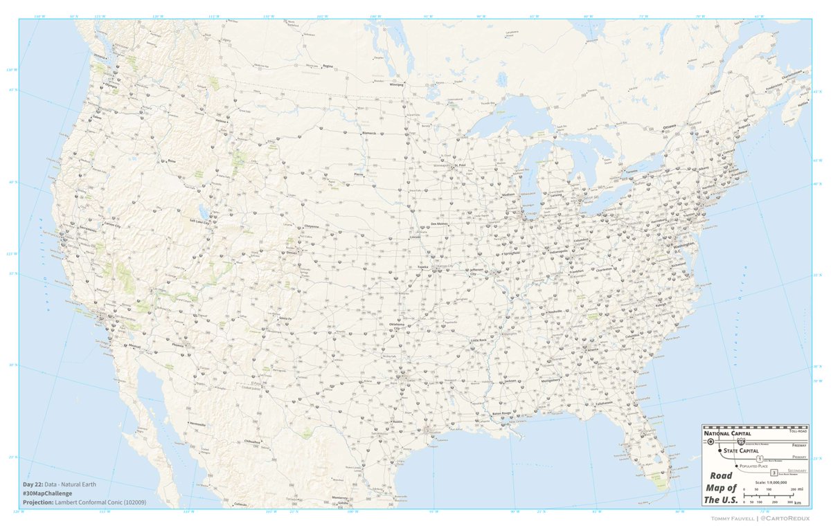
Tommy Fauvell built a road map of the U.S. AND a reusable #ArcGISPro project to help you fully leverage the Natural Earth public domain map dataset. Explore it for yourself today! #30DayMapChallenge day 22: ow.ly/rkou50XwgvM

To prove her day 13 map was built using #ArcGISPro in under 10 minutes, Grace Anderson created a real-time tutorial video showing the entire process behind her soil types in Yosemite National Park map! ow.ly/qWqj50XwycG
From forests to trees, features are uniquely visualized across the different @Esri basemaps. Using #ArcGISPro, Cindy Prostak mapped ways trees are symbolized. 🌳Take a “walk” and marvel at the distinctive foliage.🚶♀️ #30DayMapChallenge day 21: ow.ly/mRQL50XvNVZ

What if you project a projection? 🤔🌎Created in #ArcGISPro using picture markers and a creative twist on the View Dome tool, @nathancshephard’s animation “pushes” each map projection out from the place it was invented. #30DayMapChallenge day 19: ow.ly/CUjr50Xua5g
Arcade + Census = socioeconomic mapping magic ✨ Lisa Berry highlights areas in LA at risk during emergencies. She made an index-calculated map in #ArcGISPro using polygons based on 5 factors like access to internet and vehicles. #30DayMapChallenge day 3: ow.ly/64RP50XlMfU


The #ArcGISPro team is so excited to participate in the upcoming #30DayMapChallenge! Check out our page everyday this November (yes, even weekends!) to follow along for the journey. Looking forward to 30 days of maps galore! About the challenge: ow.ly/pknY50Xk0fH

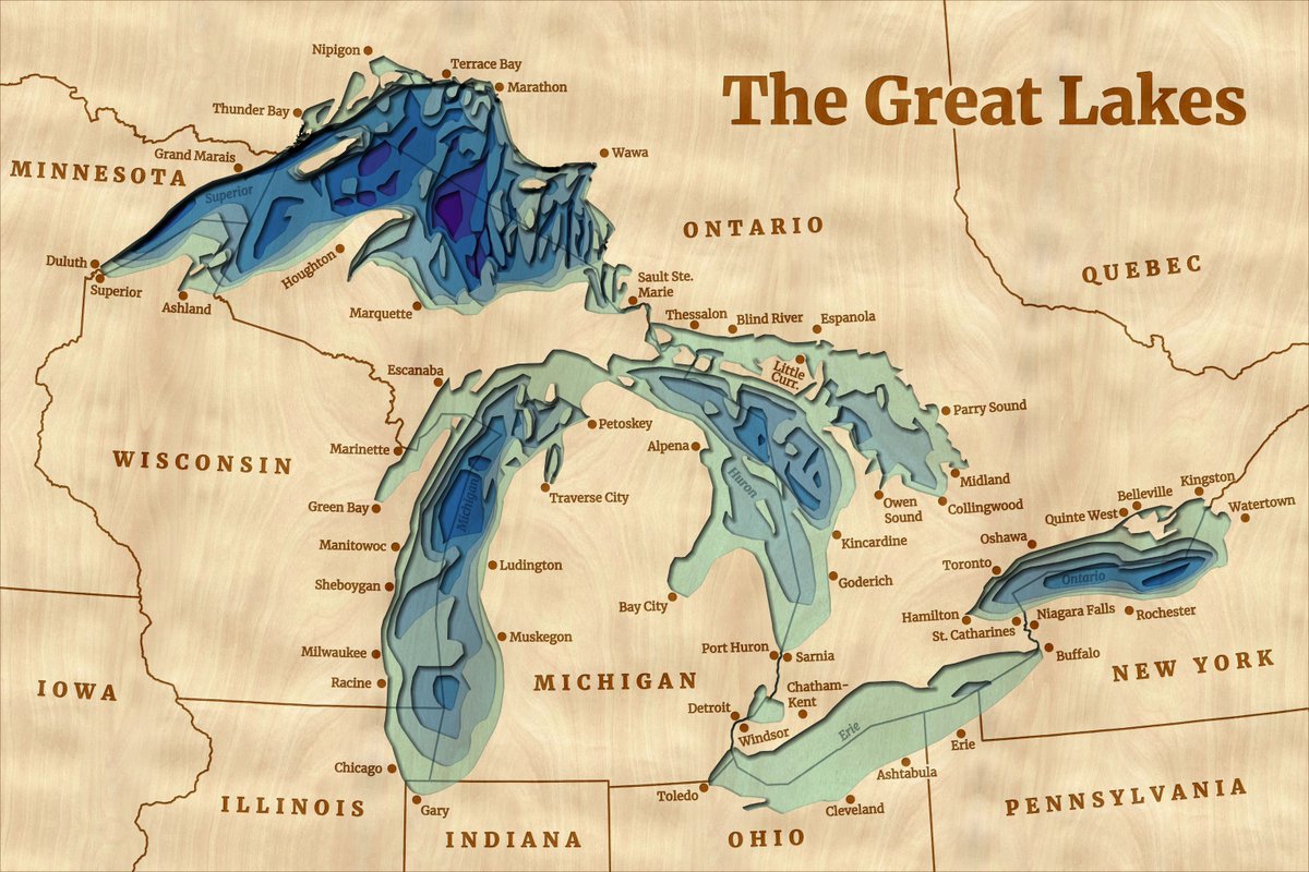
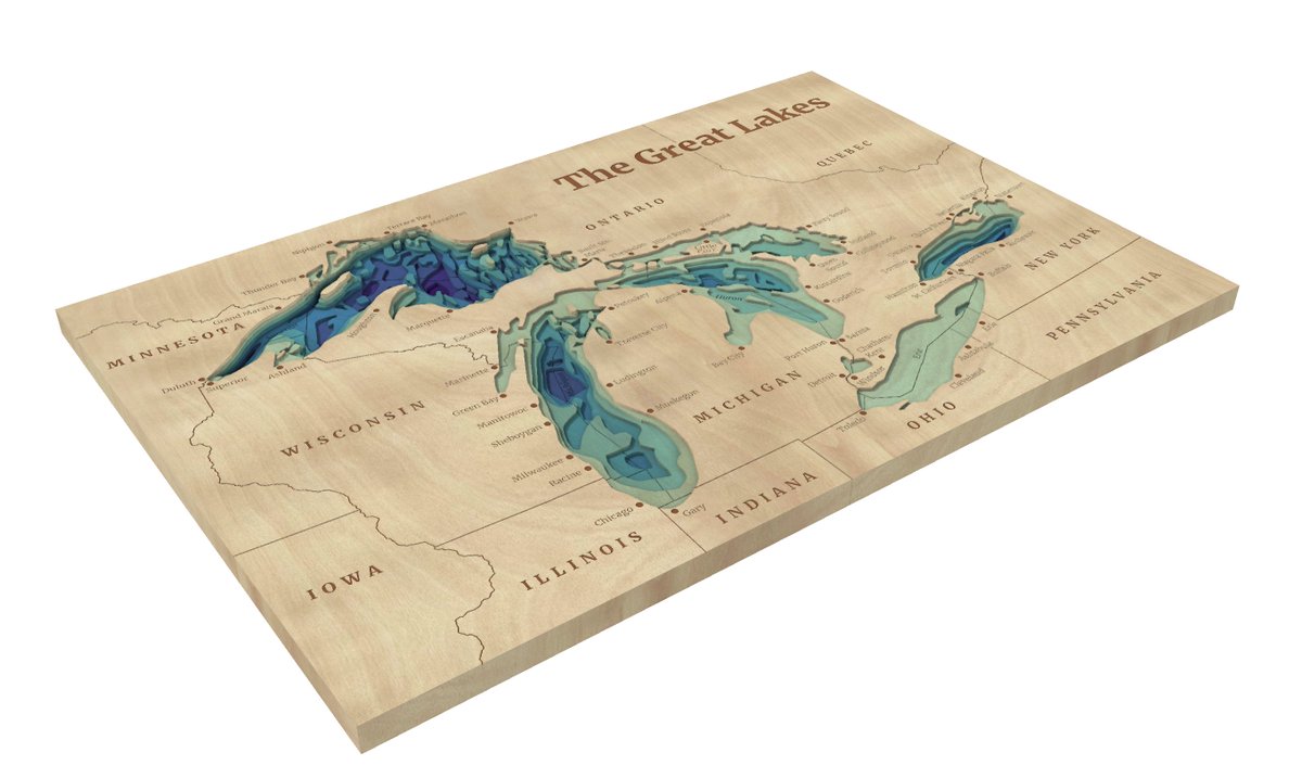
🌊 Wooden lake maps are a classic Midwest cabin decor, often showing bathymetry in thin layers of wood. 🪵 Noel Peterson crafted 2D &3D digital representations of these in #ArcGISPro! Check out day 20 of the #30DayMapChallenge: ow.ly/irNB50XuMBX


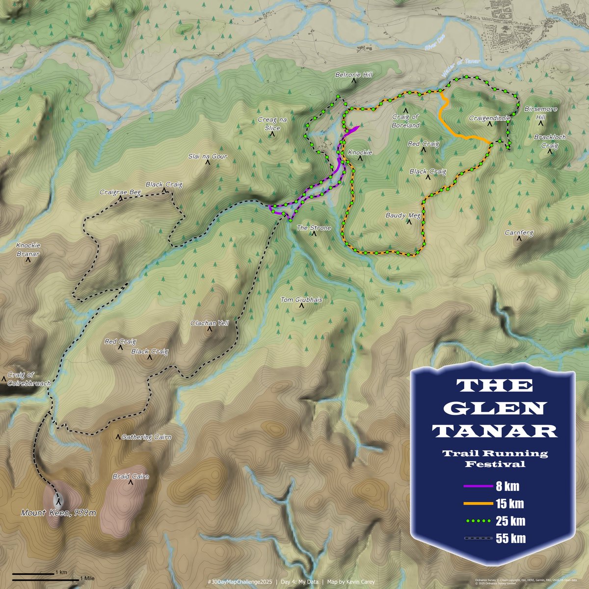
Day 4: My Data - Back in July I completed the 8km route at the Glen Tanar Trail Running Festival #30DayMapChallenge #ArcGISPro #GlenTanar
Day 6: Dimensions The UK’s remotest pub can only be reached by ferry or a 25km hike. I really want to hike this one day. #30DayMapChallenge #arcgispro #gischat #canva


Carte de la France - Institut Géographique National - 1971 3D Render with Bathymetry #France #ArcGISPro #cartography #b3d


Juanita Arch - Colorado, Mesa Co. - USGS / US Atomic Energy Commission - 1949 3D Render #colorado #ArcGISPro #cartography #b3d


Using #ArcGISPro, Aubri Otis mapped the “Made In” labels from items in her house, creating a visual representation of her home’s global connections for the “My Data” theme. Check out day 4 of the #30DayMapChallenge: ow.ly/WFHz50Xm8Bm

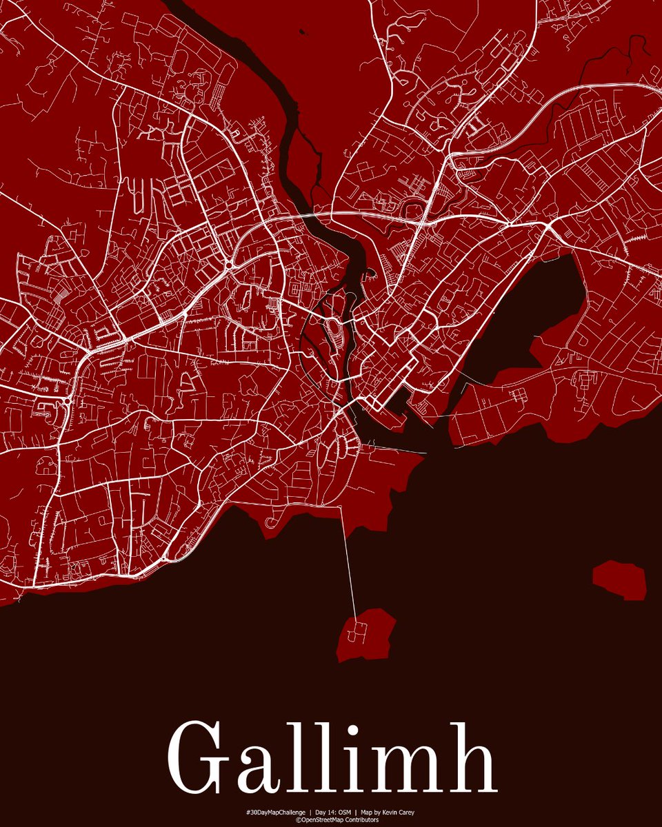
Day 14: Open Street Map data I may be biased but Gallimh (Galway) is the best city in Ireland ❤️ I love how easy it easy to get OSM data from QGIS and the quick OSM plugin. #30daymapchallenge #arcgispro #qgis #gischat #galway

Grace Anderson mapped Yosemite National Park's soil types in under 10 minutes using #ArcGISPro and ArcGIS Living Atlas data. New tools like Spatial Definition Query and Search for Colors made for quicker mapping. #30DayMapChallenge day 13: ow.ly/GCM350Xt9Xc

If you want a higher res version of the Mount St. Helens patent map, you can get it here: drive.google.com/file/d/1dtHwC7… #pnw #mountsthelens #arcgispro #b3d

To prove her day 13 map was built using #ArcGISPro in under 10 minutes, Grace Anderson created a real-time tutorial video showing the entire process behind her soil types in Yosemite National Park map! ow.ly/qWqj50XwycG
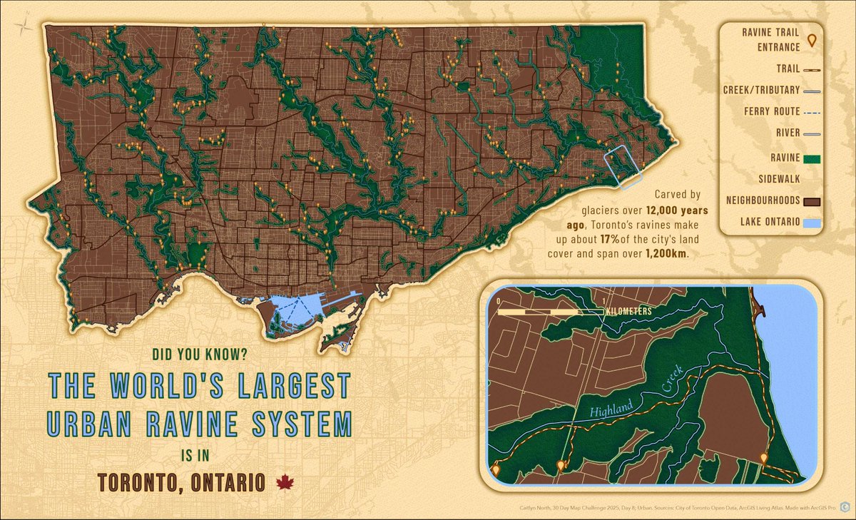
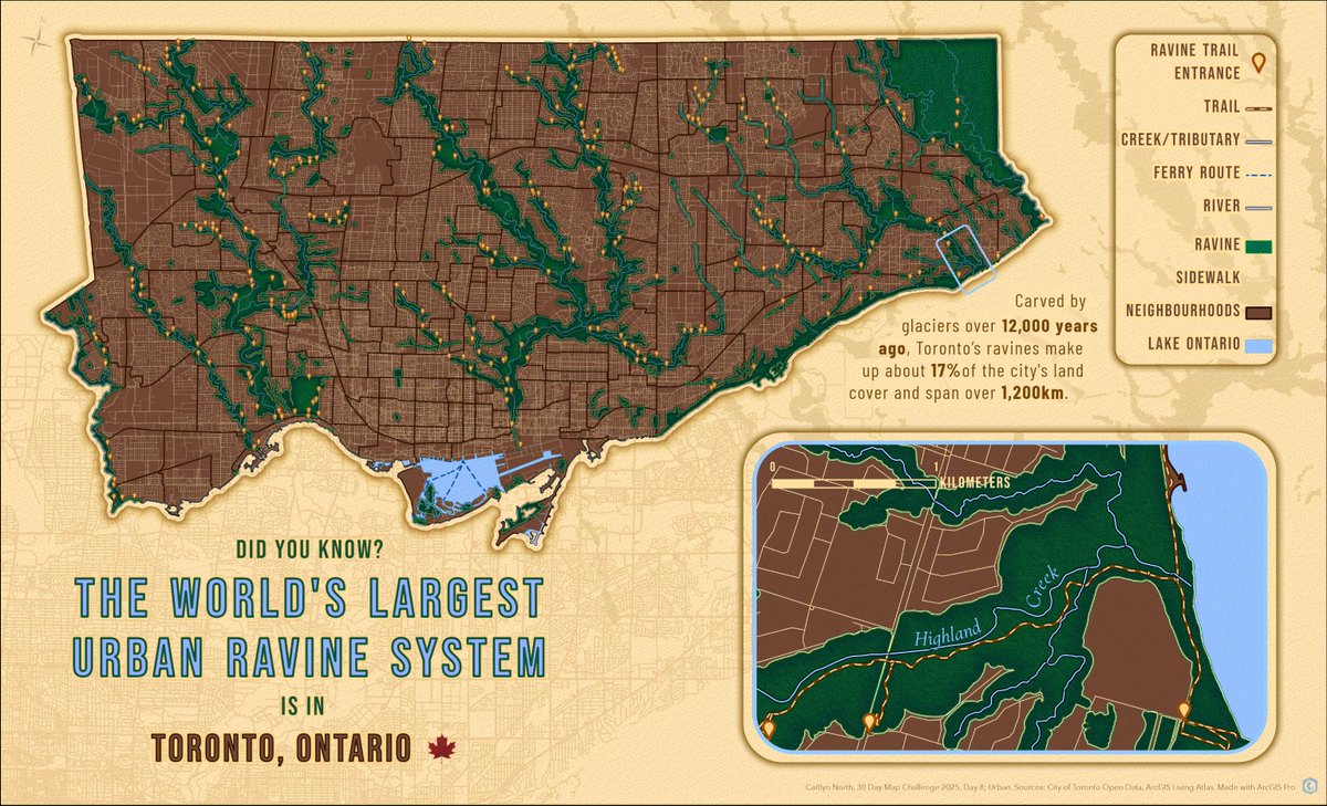
Using #ArcGISPro, Caitlyn North mapped the urban sanctuary many Torontonians use to escape the hustle and bustle of the city. ArcGIS Living Atlas data and custom symbology brought Toronto’s 1,200 km ravine system to life. 🌳 #30DayMapChallenge day 8: ow.ly/BsCu50Xt9oi

That’s a wrap on the #30DayMapChallenge week 3! This week, the #ArcGISPro Team showcased the keystone role prairie dogs play in shaping ecosystems, projected… projections, explored the many ways trees are stylized in Esri basemaps +more! Get a recap here:ow.ly/AXmC50Xwgee
Tommy Fauvell built a road map of the U.S. AND a reusable #ArcGISPro project to help you fully leverage the Natural Earth public domain map dataset. Explore it for yourself today! #30DayMapChallenge day 22: ow.ly/rkou50XwgvM
That's a wrap on the #30DayMapChallenge week 1! From the birth places of NHL players to an accessible map of the Rio Grande Rift, we learned some cool stuff and saw some great maps from the #ArcGISPro Team! Get a recap of the week here: ow.ly/5Hau50Xt9hE
That’s a wrap on the #30DayMapChallenge week 3! This week, the #ArcGISPro Team showcased the keystone role prairie dogs play in shaping ecosystems, projected… projections, explored the many ways trees are stylized in @Esri basemaps +more! Get a recap here:ow.ly/qevO50XvZWU
From forests to trees, features are uniquely visualized across the different @Esri basemaps. Using #ArcGISPro, Cindy Prostak mapped ways trees are symbolized. 🌳Take a “walk” and marvel at the distinctive foliage.🚶♀️ #30DayMapChallenge day 21: ow.ly/mRQL50XvNVZ

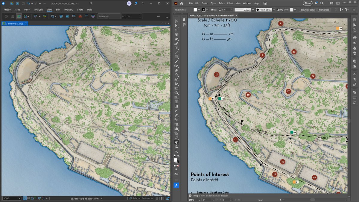
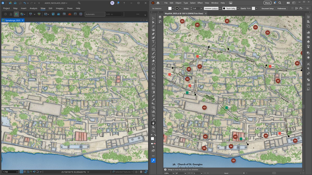
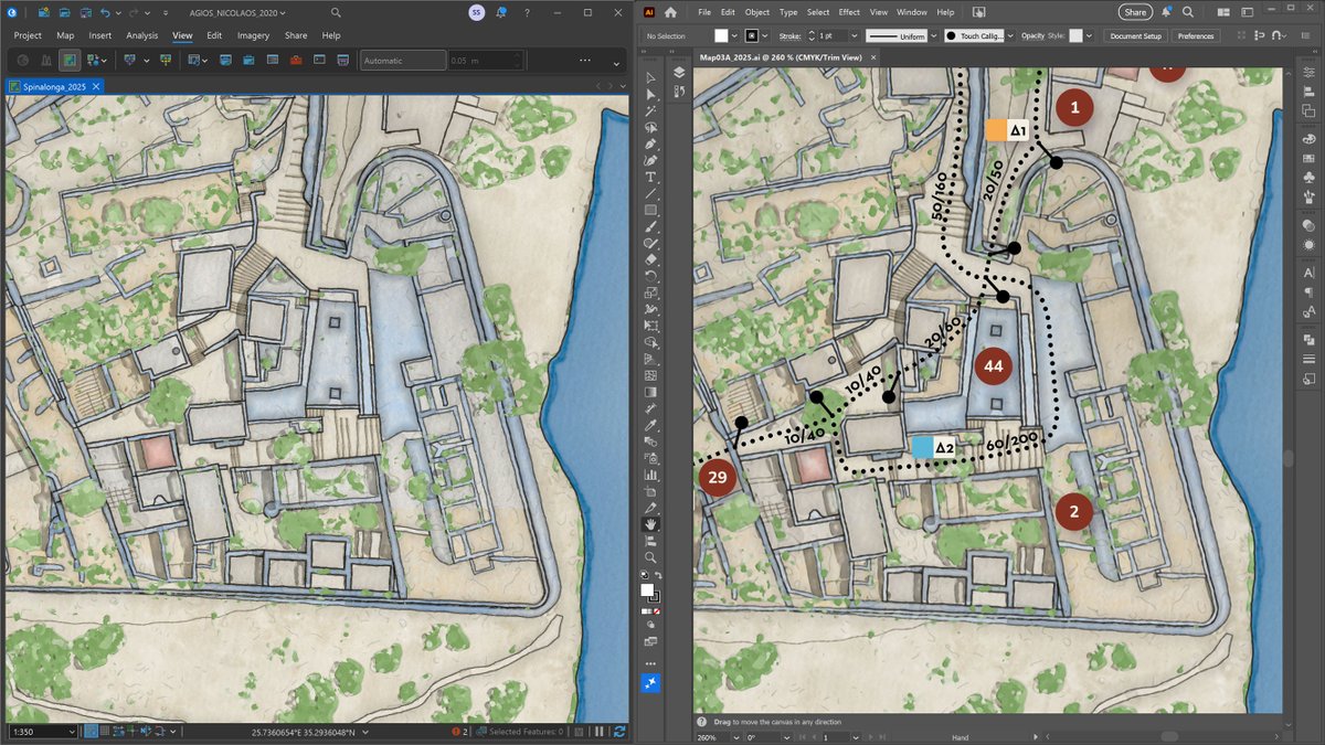
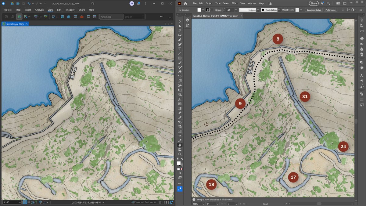
Redesign of an old, large-scale hand-drawn map I had created for the arch. site on the islet of #Spinalonga #Crete. On the left, the map design and coloring process in #ArcGISPro on the right, the final composition in #AdobeIllustrator. To be featured in my new online portfolio.

Create precise, automated 2D/3D maps with ArcGIS Pro and share seamlessly via ArcGIS Online—smart, scalable GIS made simple. #EsriIndia #GIS #ArcGISPro #DesignTech @EsriIndia

🌐🌊 Mañana empieza el #curso que formará a los alumnos en el manejo de #ArcGISPro aplicado al ámbito marino. 🔗 Web: bit.ly/Curso_PRO_MM 💻 Online 📅 20 de noviembre 🕘 160 h. ✅ Descuentos ℹ bit.ly/Form_PRO_Marino 📧 [email protected] #SIG #marino #MedioAmbiente

Day 21: Icons I turned my local woods into a Pokémon hunt for my boys. I found a Pokémon tile set on Devian Art from ChaoticCherryCake and using Inkscape I clipped the images so I could use them as symbology in Pro. #30DayMapChallenge #ArcGisPro #Canva #Pokemon #gischat

🌊 Wooden lake maps are a classic Midwest cabin decor, often showing bathymetry in thin layers of wood. 🪵 Noel Peterson crafted 2D &3D digital representations of these in #ArcGISPro! Check out day 20 of the #30DayMapChallenge: ow.ly/x0hc50XuWrP

🌊 Wooden lake maps are a classic Midwest cabin decor, often showing bathymetry in thin layers of wood. 🪵 Noel Peterson crafted 2D &3D digital representations of these in #ArcGISPro! Check out day 20 of the #30DayMapChallenge: ow.ly/irNB50XuMBX

List Excel File Sheet Names as an Input Parameter for Custom tools in #ArcGISPro with #ArcPy & #Pandas learn.finaldraftmapping.com/list-excel-fil…

Inspired by her love of geology and collecting national park postcards, Iza Ogilive created this Earth themed map using John Nelson’s Postcard style and Sentinel-2 satellite imagery in #ArcGISPro! Check out day 5 of the #30DayMapChallenge: ow.ly/krAU50Xt90G


Inspired by her love of geology and collecting national park postcards, Iza Ogilive created this Earth themed map using @John_M_Nelson’s Postcard style and Sentinel-2 satellite imagery in #ArcGISPro! Check out day 5 of the #30DayMapChallenge: ow.ly/Fq0y50XmPi7
Carte de la France - Institut Géographique National - 1971 3D Render with Bathymetry #France #ArcGISPro #cartography #b3d
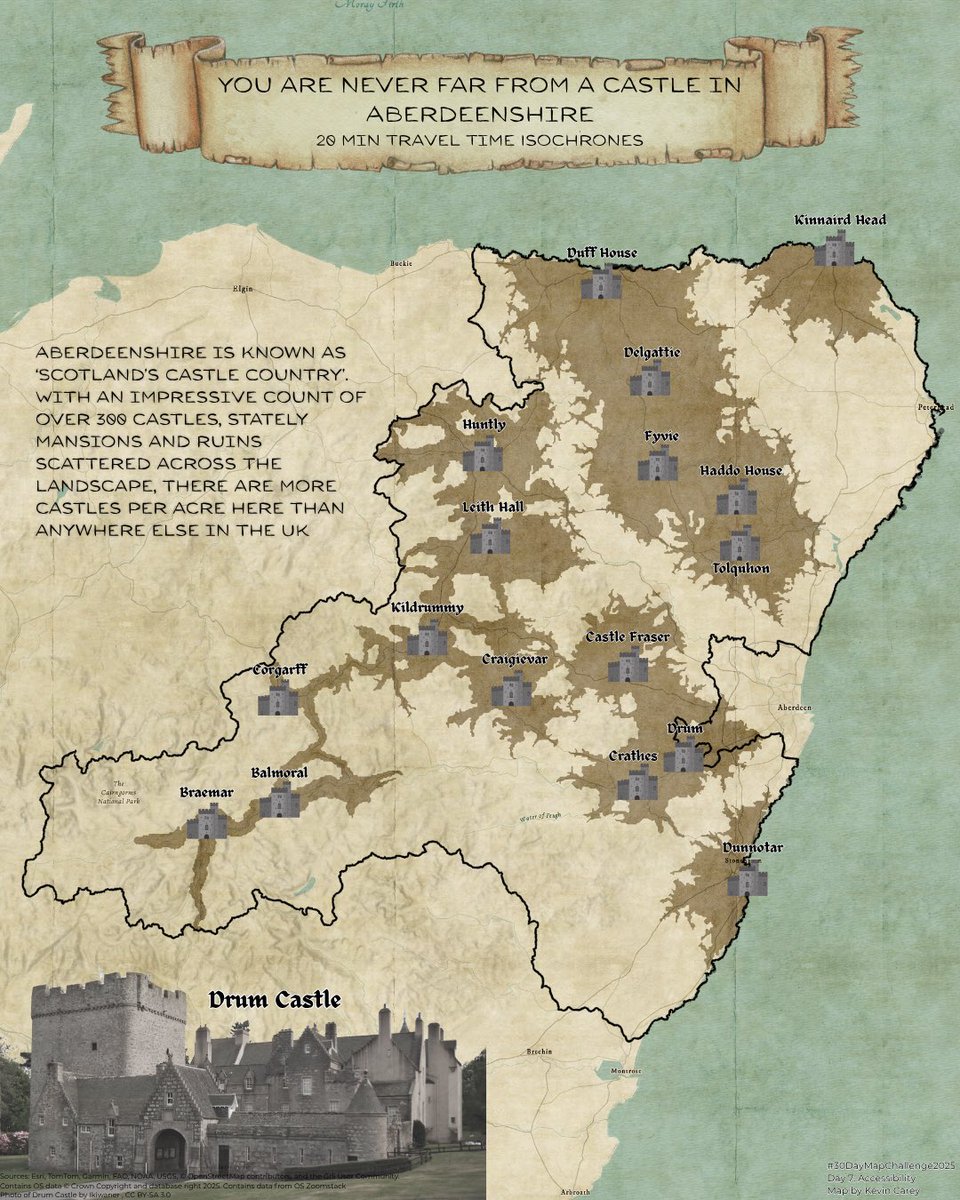
Day 7: Accessibility Isochrones created using the TravelTime Plugin in QGIS. Finishing touches ArcGISPro and Canva #30DayMapChallenge #qgis #arcgispro #canva #VisitScotland #Aberdeenshire
Day 6: Dimensions The UK’s remotest pub can only be reached by ferry or a 25km hike. I really want to hike this one day. #30DayMapChallenge #arcgispro #gischat #canva
The #ArcGISPro team is so excited to participate in the upcoming #30DayMapChallenge! Check out our page everyday this November (yes, even weekends!) to follow along for the journey. Looking forward to 30 days of maps galore! About the challenge: ow.ly/pknY50Xk0fH
Arcade + Census = socioeconomic mapping magic ✨ Lisa Berry highlights areas in LA at risk during emergencies. She made an index-calculated map in #ArcGISPro using polygons based on 5 factors like access to internet and vehicles. #30DayMapChallenge day 3: ow.ly/64RP50XlMfU


Juanita Arch - Colorado, Mesa Co. - USGS / US Atomic Energy Commission - 1949 3D Render #colorado #ArcGISPro #cartography #b3d
Day 4: My Data - Back in July I completed the 8km route at the Glen Tanar Trail Running Festival #30DayMapChallenge #ArcGISPro #GlenTanar
Making good progress on my block diagram workflow! I exported all layers from #ArcGISPro one at a time using a bookmarked extent, refined each layer in Photoshop & then assembled the full diagram step by step in Illustrator. All layers linked in the workflow for dynamic updates.

The secret sauce to creating a truly realistic 3D terrain scene in #ArcGISPro is the Curvature layer! Placing it on top of the Shaded Relief layer, it enhances the details. Notice the difference with and without it as I rotate the view. #cARTography #MakingMapsPretty

If you want a higher res version of the Mount St. Helens patent map, you can get it here: drive.google.com/file/d/1dtHwC7… #pnw #mountsthelens #arcgispro #b3d
Using #ArcGISPro, Caitlyn North mapped the urban sanctuary many Torontonians use to escape the hustle and bustle of the city. ArcGIS Living Atlas data and custom symbology brought Toronto’s 1,200 km ravine system to life! #30DayMapChallenge day 8: ow.ly/FwzE50XoBn4
Cartography expert @John_M_Nelson shares a way to make labels really big, but also somewhat muted. In this case they end up looking a little glassy. But you can tweak this method to look however you like in #ArcGISPro! > ow.ly/H35L50XgAQl

Svalbard, Norway - Norsk Polarinstitutt - 1980 3D Render #Svalbard #Norway #ArcGISPro #cartography #b3d


Using #ArcGISPro, Aubri Otis mapped the “Made In” labels from items in her house, creating a visual representation of her home’s global connections for the “My Data” theme. Check out day 4 of the #30DayMapChallenge: ow.ly/WFHz50Xm8Bm

Day 14: Open Street Map data I may be biased but Gallimh (Galway) is the best city in Ireland ❤️ I love how easy it easy to get OSM data from QGIS and the quick OSM plugin. #30daymapchallenge #arcgispro #qgis #gischat #galway
Something went wrong.
Something went wrong.
United States Trends
- 1. Cowboys 46.4K posts
- 2. Eagles 73.6K posts
- 3. Ceedee 12.5K posts
- 4. Browns 66.3K posts
- 5. Raiders 44.2K posts
- 6. Pickens 12.6K posts
- 7. Nimmo 14.5K posts
- 8. Saquon 4,496 posts
- 9. Trevor Lawrence 3,219 posts
- 10. Myles Garrett 7,536 posts
- 11. Tom Brady 6,106 posts
- 12. Mets 20.6K posts
- 13. Shedeur 67.9K posts
- 14. Semien 9,303 posts
- 15. Jags 4,979 posts
- 16. Jalen 20.2K posts
- 17. Giants 89.5K posts
- 18. Turpin 3,445 posts
- 19. Colts 41K posts
- 20. #PHIvsDAL 4,700 posts