#arcgispro search results

Big changes can come with big rewards. Here’s how the @TNCOT got 72 counties on board with ArcGIS Pro for better collaboration, communication, and productivity. ow.ly/AI0u50X0z8x #ArcGISPro


From DEMs to DTMs! 🏞️ 3 proven ways to create high-quality Digital Terrain Models in ArcGIS Pro, from photogrammetry to LiDAR. Learn how to capture the bare-earth surface like a pro 👉 esri.com/arcgis-blog/pr… #DTM #GIS #ArcGISPro #Geoawesome #RemoteSensing


Cut manual edits and improve data quality. Use calculation attribute rules in #ArcGISPro to auto-populate correct values with Arcade. Watch the short video: ow.ly/792950YCPll


Jump into @ArcGISPro with the popular textbook, "GIS Tutorial for ArcGIS Pro 3.4". Complete with teaching resources such as video lectures and slides, this book is ideal for teaching new students of #ArcGISPro. This book is available for sampling now 📚 ow.ly/v4np50VZgIr


New to ArcGIS Pro? 🗺️ Our 8-course learning plan will get you up to speed: esri.social/BfHF50SpzMf @ArcGISPro #ArcGISPro

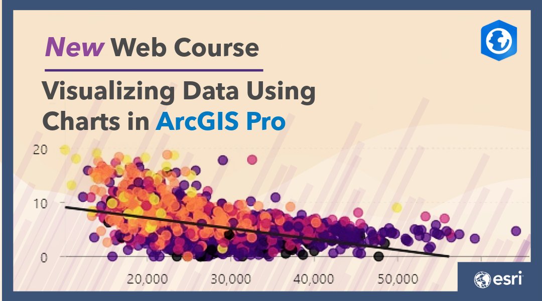
Spot trends faster. In this free web course, you will learn how to visualize data, explore relationships, and interpret patterns using charts in #ArcGISPro. Start Learning Today: ow.ly/xc7I50YyxE1
Soil carbon is a powerful climate indicator. Use multidimensional raster tools in #ArcGISPro to track changes across time and depth, then pull in the ArcGIS Living Atlas soil layer to calculate average carbon content. Watch the video: ow.ly/ETsH50YxvVQ
Still using ArcMap? It's time to make the move to @ArcGISPro. This course will help you with the migration → esri.social/61Ml50TJbyj #ArcMap #ArcGISPro

Did you know there's an estimated 350 million people in the world who are colorblind? Here are tips for creating maps that are accessible for everyone. 🗺️ ow.ly/PMRj50Vc1yB #ArcGISPro
In #ArcGISPro, metadata provides essential information to describe your GIS items. Join this live training seminar to learn about the importance of metadata for AI-readiness, and the tools #ArcGIS offers to streamline creation: ow.ly/Wagh50Yy23K

Carve out the exact area you need. Grab a Living Atlas layer, apply a definition query in #ArcGISPro to isolate the features you care about, then run the Erase tool to create a clean cutout for your map layout. Watch the video: ow.ly/rhnK50Ytxhc
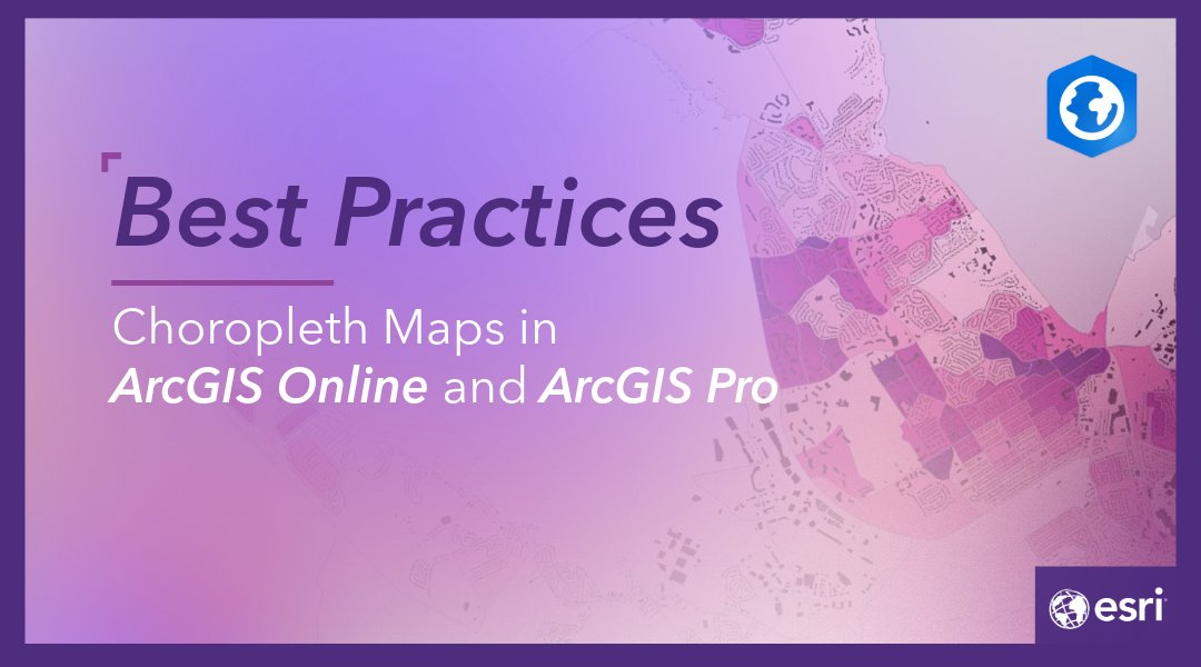
Choropleth maps can be misleading. Access short videos that break down why normalization matters and how to map filled areas in #ArcGISOnline and #ArcGISPro so your audience easily sees patterns. Learn More: ow.ly/oX7K50YMIIE
See where water challenges are most urgent. 🌍 Drop Aqueduct’s global water risk layers into #ArcGISPro to reveal where stress, drought, and demand collide so you can act fast with policy ready insight. Explore the Layer: ow.ly/7B0n50YvrfL


Cómo conectar ArcMap y #ArcGIS Pro con #PostGIS rviv.ly/rA9h4T #ArcGISPro

Want to improve your #GIS data quality and reduce data management cost? #ArcGIS Data Reviewer is an extension for #ArcGISPro that automates, simplifies, and improves data quality management workflows. Try 21-day free trial: ow.ly/BQAP50YxPpa
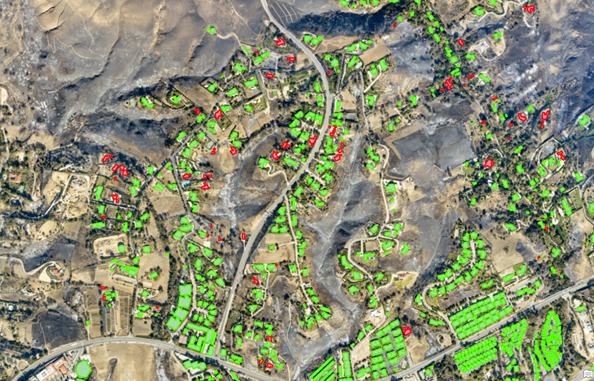
Deep learning can save time by automating common imagery tasks. 🔥Play the role of a wildfire analyst and learn how to classify objects using deep learning in @ArcGISPro. Free ArcGIS lab: esri.social/k5R950TvqU7 #imagery #deeplearning #arcgispro
Make every label count. In #ArcGISPro you can auto‑create a label class for each symbol class, so every feature gets rules that fit its style. No label gets left behind. See how it works: ow.ly/45H150YtJjw

Tired of rebuilding geodatabases that mysteriously vanish from your project? This tip shows how #ArcGISPro helps you quickly locate missing items so you can get back to editing and analysis without starting over. Get the Tip: ow.ly/A3kR50YHijV

If you want to start your spatial data learning before our next MOOC opens, check out this lab ➡️ esri.social/Hx2e50SvSW7 Play the role of a 🔥wildfire analyst and train a deep learning model to classify buildings as damaged using 🌎ArcGIS Pro! #ArcGISPro #DeepLearning


How to Use Google Earth Engine with ArcGIS Pro | Complete Integration Tutorial. Tutorial Link: youtube.com/live/7OF1Ha1ln… #googleearthengine #ArcGISPro #GIS #remotesensing #geospatial #satelliteimagery #EarthObservation #PythonGIS #SpatialAnalysis #GEE

Get #ArcGISPro insights, tutorials, and product updates wherever you are. More ways to stay connected. Follow Us on LI: ow.ly/gXIJ50YP3rO

Resilience works best when it’s part of everyday city life. Projects like the Big U show how flood protection can be integrated into the urban fabric—supporting both safety and public use while enhancing how cities function. #GeoSWMM #ArcGISPro #FloodModeling #UrbanDrainage

Hosted AI models are now the fastest way to tap into language, vision, and multimodal intelligence. Learn how #ArcGISPro connects securely to third party AI services through a reusable AI Service Connection File. Check Out the Blog: ow.ly/jxnY50YP1YR

When one attribute isn’t enough, bivariate maps help reveal deeper patterns. See how #ArcGISPro uses blended colors to compare two things at once so relationships and trends become clear. Explore the examples: ow.ly/Qgap50YMJbJ


📑 Getting to Know ArcGIS Pro 3.6 (EPub) 📥 Download PDF: civilsolution.in/products/Getti… #ArcGISPro #ArcGISPro36 #GISLearning #GISBook #GeospatialEducation #MappingSkills #GISSoftware #GeographicInformationSystem #SpatialAnalysis #Cartography #GeospatialAnalysis #RemoteSensing #GIS


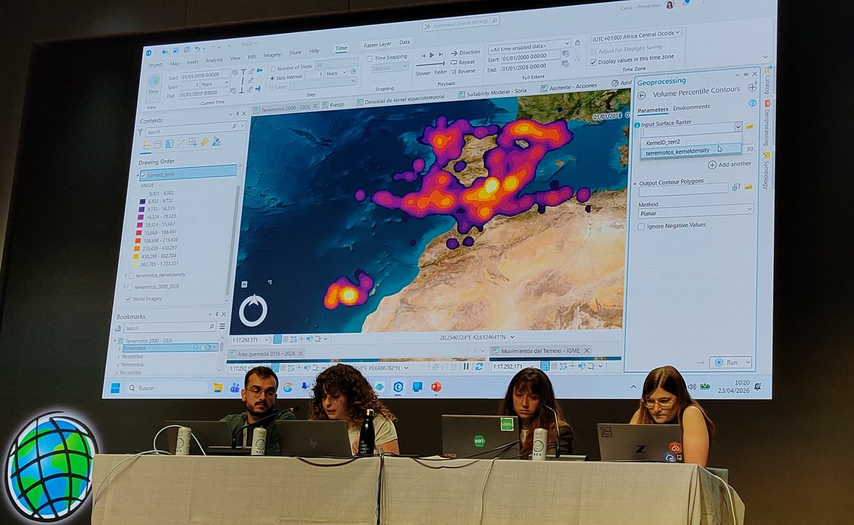
Nuevas herramientas de análisis de kernels, embedings, documentación offline, nuevo modelo builder... ¡Mogollon de novedades en las versiones de @ArcGISPro 3.6 y 3.7, que enseña Celia Gil hoy! #EsriTechDay 🌍 @Esri_Spain 💻 #ArcGISPro
Electricity costs are climbing nationwide. Explore how rates have changed from 2000 to 2024 using a new ArcGIS Living Atlas layer in #ArcGISPro. Map service territories or zoom into H3 hexagons for more granular trends across the US. Explore the layer: ow.ly/MCIF50YO69o


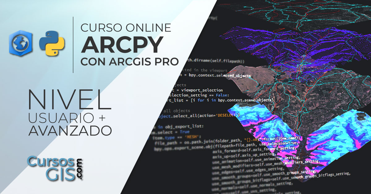
🌍🐍 Este curso capacitará a los alumnos en el manejo del lenguaje Python dentro de ArcGIS Pro. 🌐 Web: cursosgis.com/curso-online-d… 💻 Modalidad online 📅 12 de mayo 🕘 160 horas ✅ Descuentos ℹ bit.ly/Form_Python_Pr… 📧 [email protected] #python #ArcPy #ArcGISPro
Choropleth maps can be misleading. Access short videos that break down why normalization matters and how to map filled areas in #ArcGISOnline and #ArcGISPro so your audience easily sees patterns. Learn More: ow.ly/oX7K50YMIIE
🌿🌐 Este curso formará al alumno en el manejo de ArcGIS para la elaboración de estudios relacionados medioambientales. 🔗 bit.ly/Curso_PRO_MA 💻 Online 📅 21 de abril 🕘 140 h. ✅ Descuentos ℹ bit.ly/Form_PRO_MA 📧 [email protected] #ArcGISPro #MedioAmbiente


ArcGIS Pro: Essential Workflows bridges the gap between knowing the interface and using it with purpose. You’ll learn how the tools fit together so your workflows feel intentional. Register to get started: ow.ly/7bhu50YKQTX #EsriCanadaTraining #ArcGISPro #EsriCanada


Practice makes GIS professionals stronger 💡 This EAPA_2025 quiz helps you test your skills in mapping, data management, and spatial analysis using ArcGIS Pro-a smart step before the real exam. forms.gle/32mzWdJa1DWsjY… #Esri #EAPA2025 #ArcGISPro #ArcGISProAssociate #GIS

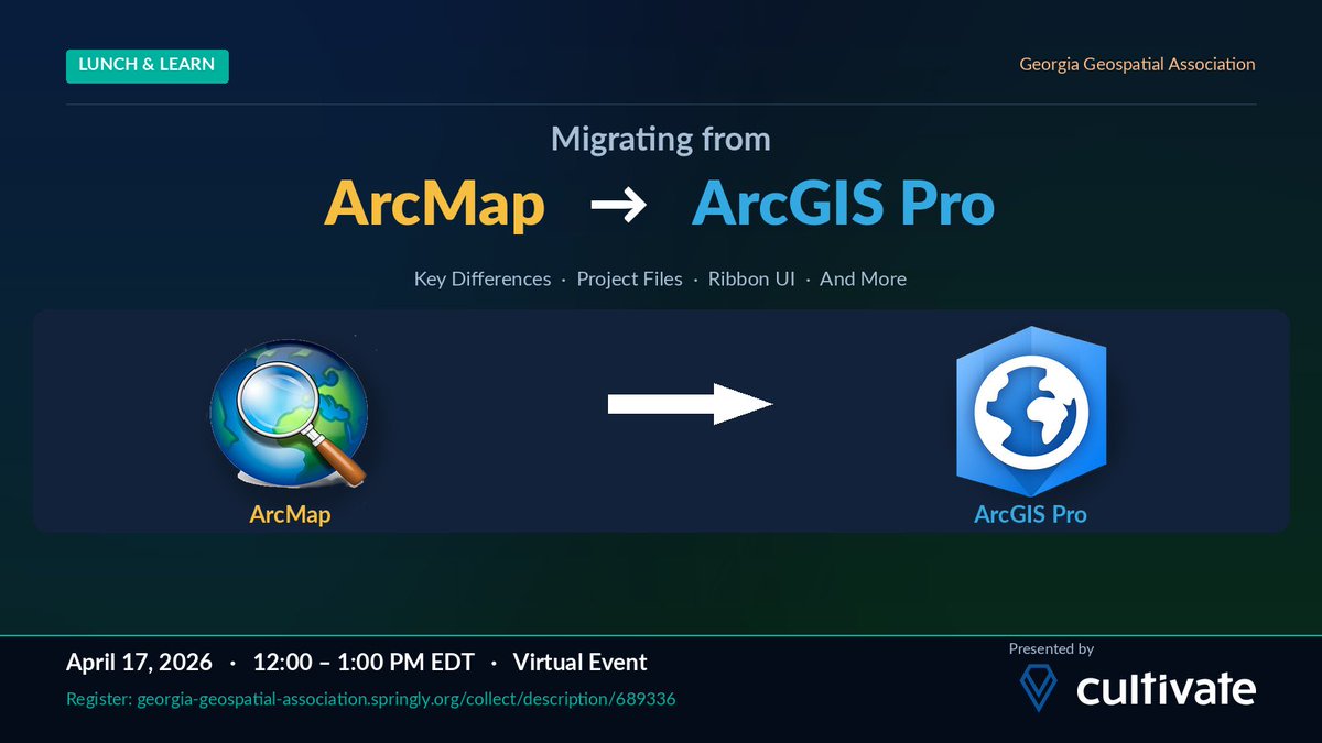
Join me this Friday for the Central Savannah River Area Chapter of Georgia Geospatial Association free Virtual Lunch and Learn of the Year as I present on Migrating to ArcGIS Pro. Go to …a-geospatial-association.springly.org/collect/descri… to register for this free event. #ArcGISPro
Tired of rebuilding geodatabases that mysteriously vanish from your project? This tip shows how #ArcGISPro helps you quickly locate missing items so you can get back to editing and analysis without starting over. Get the Tip: ow.ly/A3kR50YHijV

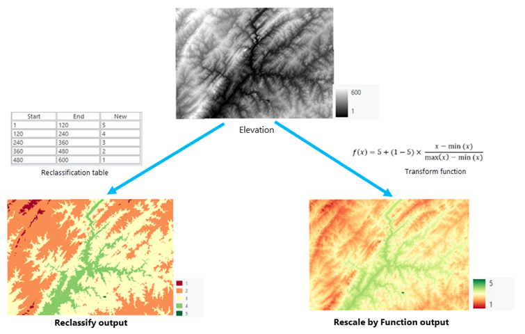
Transforming #Raster #Data with Continuous Functions in #ArcGISPro tinyurl.com/3pvfkkaz #images #imagery #GIS #esri #arcgis #GISchat #geospatial #analysis @esri @EsriSLGov @ArcGISPro @URISA
🌐 Este curso enseñará al alumno a trabajar con ArcGIS Pro para la preparación, maquetación y entrega de cartografía de calidad. 🔗 bit.ly/Curso_PRO_Esp 💻 Online 📅 15 de abril 🕘 160 horas ✅ DescuentoS ℹ bit.ly/Form_PRO_Esp 📧 [email protected] #SIG #ArcGISPro


Get product updates, expert tips, and curated resources delivered to your inbox. Sign Up for the #ArcGISPro Newsletter: ow.ly/ETa650YJ7yb


From DEMs to DTMs! 🏞️ 3 proven ways to create high-quality Digital Terrain Models in ArcGIS Pro, from photogrammetry to LiDAR. Learn how to capture the bare-earth surface like a pro 👉 esri.com/arcgis-blog/pr… #DTM #GIS #ArcGISPro #Geoawesome #RemoteSensing
Big changes can come with big rewards. Here’s how the @TNCOT got 72 counties on board with ArcGIS Pro for better collaboration, communication, and productivity. ow.ly/AI0u50X0z8x #ArcGISPro
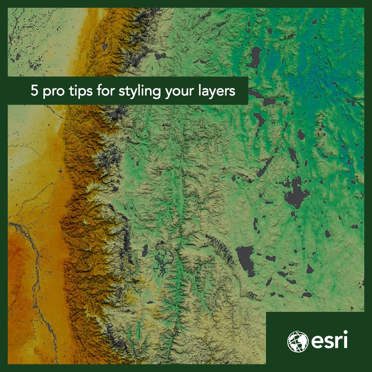
Want to create a more user-friendly web map? 🗺️ Here are five tips and tricks for customizing your layers and maps that don't take much time. esri.social/qxJU50UEFqH #ArcGISOnline #ArcGISPro
Hosted AI models are now the fastest way to tap into language, vision, and multimodal intelligence. Learn how #ArcGISPro connects securely to third party AI services through a reusable AI Service Connection File. Check Out the Blog: ow.ly/jxnY50YP1YR
Get #ArcGISPro insights, tutorials, and product updates wherever you are. More ways to stay connected. Follow us LI:ow.ly/nzwA50YBLJk Follow us on FB: ow.ly/b7rz50YBLJl

When one attribute isn’t enough, bivariate maps help reveal deeper patterns. See how #ArcGISPro uses blended colors to compare two things at once so relationships and trends become clear. Explore the examples: ow.ly/Qgap50YMJbJ
Tired of rebuilding geodatabases that mysteriously vanish from your project? This tip shows how #ArcGISPro helps you quickly locate missing items so you can get back to editing and analysis without starting over. Get the Tip: ow.ly/A3kR50YHijV
🌍 ArcMap retired in March, but your move to #ArcGISPro may just be getting started. This migration guide shows how to shift your projects and understand ArcGIS user types with tips and resources to help you at every step. Get the guide: ow.ly/qB8c50YETuf

In #ArcGISPro, metadata provides essential information to describe your GIS items. Join this live training seminar to learn about the importance of metadata for AI-readiness, and the tools #ArcGIS offers to streamline creation: ow.ly/Wagh50Yy23K
Choropleth maps can be misleading. Access short videos that break down why normalization matters and how to map filled areas in #ArcGISOnline and #ArcGISPro so your audience easily sees patterns. Learn More: ow.ly/oX7K50YMIIE
How to Use Google Earth Engine with ArcGIS Pro | Complete Integration Tutorial. Tutorial Link: youtube.com/live/7OF1Ha1ln… #googleearthengine #ArcGISPro #GIS #remotesensing #geospatial #satelliteimagery #EarthObservation #PythonGIS #SpatialAnalysis #GEE
Electricity costs are climbing nationwide. Explore how rates have changed from 2000 to 2024 using a new ArcGIS Living Atlas layer in #ArcGISPro. Map service territories or zoom into H3 hexagons for more granular trends across the US. Explore the layer: ow.ly/MCIF50YO69o
Spot trends faster. In this free web course, you will learn how to visualize data, explore relationships, and interpret patterns using charts in #ArcGISPro. Start Learning Today: ow.ly/xc7I50YyxE1

【ESRIジャパン トレーニング】 「ArcGIS Pro: 基本操作」を受講して、マップ操作の基本を習得しませんか👩💻🧑💻 🗓️日程: 4月8日(水)~10日(金) 🏫受講形式: 会場受講・リモート受講 (どちらも受付中) 🔗コース詳細: esrij.com/training/cours… 📝お申し込み方法: esrij.com/training/order/ #ArcGISPro
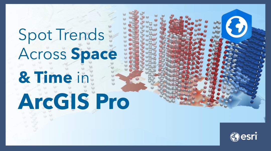
See patterns your 2D maps miss. Build a space-time cube in #ArcGISPro to explore how Florida homeownership has changed since 2010 in both space and time. It’s a fast way to spot emerging trends and shifts in your data. Try the tutorial: ow.ly/c0Ps50YCPti
Did you know there's an estimated 350 million people in the world who are colorblind? Here are tips for creating maps that are accessible for everyone. 🗺️ ow.ly/PMRj50Vc1yB #ArcGISPro
Make every label count. In #ArcGISPro you can auto‑create a label class for each symbol class, so every feature gets rules that fit its style. No label gets left behind. See how it works: ow.ly/45H150YtJjw
Cut manual edits and improve data quality. Use calculation attribute rules in #ArcGISPro to auto-populate correct values with Arcade. Watch the short video: ow.ly/792950YCPll
Better color choices lead to clearer maps. #ArcGISPro helps you apply accessible, well balanced color schemes so your data tells the right story at a glance. Use thoughtful palettes to guide attention and reveal patterns. 🎨 Read the blog: ow.ly/Ye7s50Yq8nN


What's New in #ArcGIS Production Mapping! The #ArcGISPro 3.4 and #ArcGISEnterprise 11.4 releases bring exciting updates to the Production Mapping extension. Explore enhanced tools, new functionalities and how they can benefit your organization. Learn more: esri.social/ou1a50Ug7ZF

Something went wrong.
Something went wrong.
United States Trends
- 1. JP Morgan N/A
- 2. Resident Evil N/A
- 3. Toy Story N/A
- 4. Term N/A
- 5. Ryan Walker N/A
- 6. Platner N/A
- 7. Melendez N/A
- 8. FLY ME OUT N/A
- 9. Luke Weaver N/A
- 10. Payamps N/A
- 11. Justin Crawford N/A
- 12. Maine N/A
- 13. Austin Slater N/A
- 14. Casey Means N/A
- 15. Surgeon General N/A
- 16. Nick Foles N/A
- 17. Collins N/A
- 18. Cregger N/A
- 19. Jeremiah Jackson N/A
- 20. Brandon Young N/A