#lidardata search results

Meanders are nature’s art, reshaping entire landscapes. 🌊✨ This REM of the Humboldt River was made using lidar data from the USGS, processed in QGIS, and rendered in Blender. #GIS #Blender3D #LidarData #HumboldtRiver #DataViz #Map #Mapping


Utilizing LIDAR data to develop models for estimating biomass and carbon stock in Costa Rican mangroves. 🌱🛰 #LIDARData #BiomassEstimation #CarbonStock #ModelDevelopment #CostaRica #Mangroves #CO2 #bosques #forestry

🙌New data alert! Dive into our latest Waikato LiDAR data, with the DEM, DSM, and point cloud live on the LDS now. Check out this vis of Paeroa made with the 1m DSM and aerial imagery from the LDS! 🌍✨data.linz.govt.nz/layer/120347-w… (Image: Waikato) #opendata #LidarData #Waikato #GIS


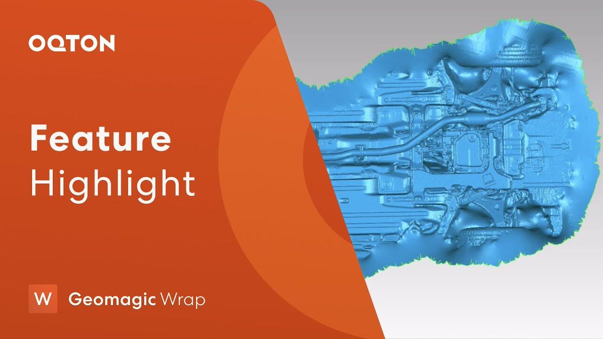
Struggling with noisy point-cloud data? Discover the advanced voxel-based triangulation tool, HD Mesh Construction, in Geomagic Wrap version 2021: youtube.com/watch?v=6plxmS… #GeomagicWrap #HDmesh #LidarData #Oqton

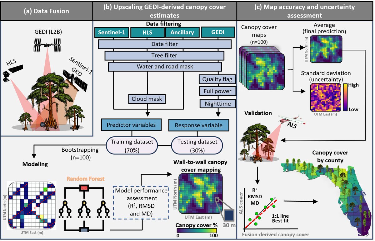
Thrilled to announce that my 1st PhD chapter on data fusion for canopy cover mapping in Florida has just been published! 🎊🌲📡 Check it out here: mdpi.com/3138712 #RemoteSensing #Forestry #LiDARdata

🚨 New data alert! 🚨 Explore our latest Northland LiDAR data, now live on the LDS! 🌍✨ Dive into the DEM, DSM, and point cloud, and check out this stunning vis of Port Whangarei made with the 1m DSM and aerial imagery. #LiDARData #Northland #GIS 🔗data.linz.govt.nz/layer/d3TxZSZ2…


Forests play a vital role in maintaining the Earth’s ecological balance, supporting biodiversity, and combating climate change. #LiDARData #LiDARCLassification #TreeClassification #ForestClassification blog.polosoftech.com/tree-point-and…


Not only can Global Mapper Pro import and export lidar data, this data can be visualized in 2D and 3D viewers by a number of the data attributes. Learn about attributes in #lidardata in this infographic! #GlobalMapper #RemoteSensing #Lidar


Transform LiDAR point clouds into stunning visuals! Overlay images and colourize your point clouds to bring data to life. polosoftech.com/lidar-drafting… #LiDARData #GISMapping #PointClouds #ImageOverlay #DataVisualization #InnovationInTech #Polosoft #Colorizing #mesmerizing

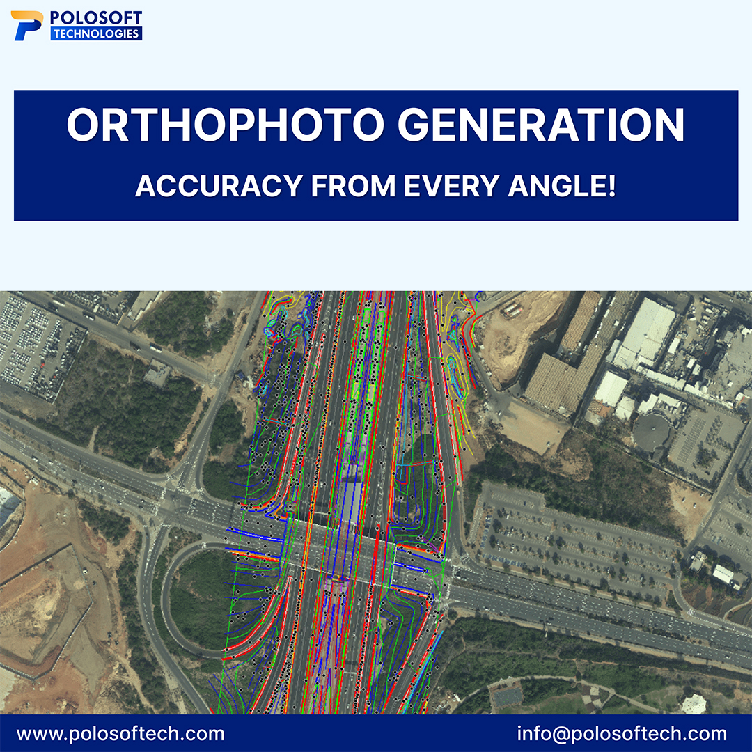
#OrthophotoGeneration: Accuracy from Every Angle! Orthophoto generation ensures precision, scale, & reliability for diverse applications in mapping, planning, and analysis. polosoftech.com/lidar-drafting… #OrthophotoGeneration #LiDARData #LiDARClassification #AerialImaging #RemoteSensing
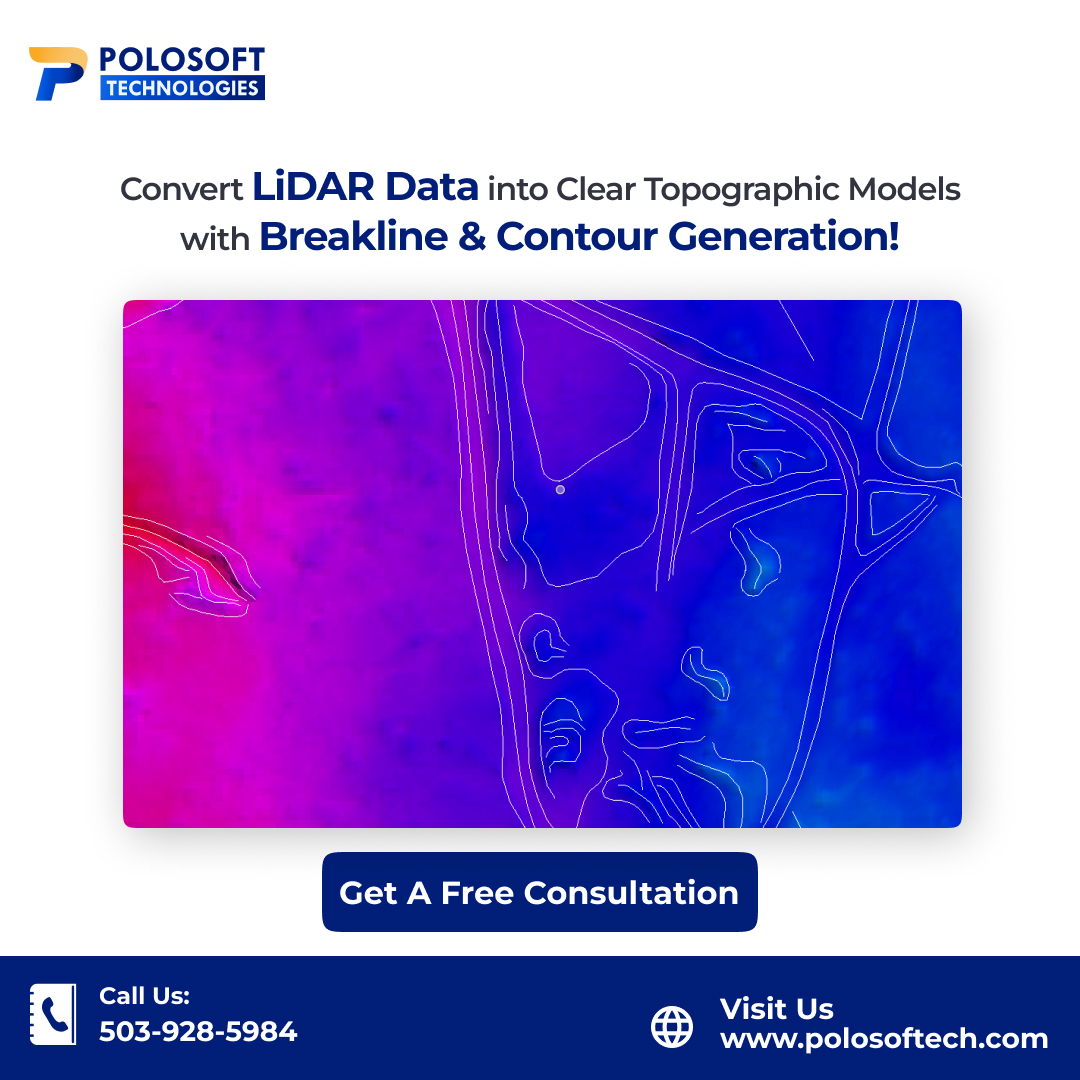
Accurate #terrainmodelling starts with quality breakline and contour generation using #LiDARdata. Enhance your topographic insights and turn raw #LiDAR data into actionable #3Dmodels. t.ly/7wGp6 #Breakline #Contourgeneration #LiDARDataAnalysis #LiDARDataProcessing
Next-level #LiDARdataprocessing and mapping to give you a precise, 3D view of your project site. Combined with our expert survey data processing, make confident decisions for your project. Contact us! bit.ly/3AhjjiZ #lidarmapping #lidardata #lidarclassification

Reach out to us for your image overlay colourization project work. Polosoft’s image overlay colourization combines LiDAR’s precision with enhanced visualization, making complex data easier to interpret. tinyurl.com/5n76fvsf #LiDARData #ImageOverlayColourization #lidar


@woolpert will use #lidardata that it had collected for the @USGS to create a high-resolution digital terrain model for the entire land area of the state of #Wyoming. bit.ly/3SCfpIA
stormwater.com
Woolpert to produce digital terrain model of Wyoming
Woolpert will use lidar data that it had collected for the USGS to create a high-resolution digital terrain model for the entire land area of the state of Wyoming.

Millions of data elements. That’s likely how many you have to manage when training AV systems. What’s valuable? Where do you find it? How do you use it? Watch a replay of our popular webinar and find out those answers, and so much more ➡️ hubs.li/Q01Q3QZz0 #LiDARdata
Which is more important: AV model safety or time to market? Finding a way to balance both is just one of the topics covered in our recent webinar, Maximizing the Value of Your AV Data. Dig into this takeaway and 3 more in this webinar recap: hubs.li/Q01T5ryj0 #LiDARdata
cloudfactory.com
4 webinar takeaways: maximizing the value of your AV data
Get the four top takeaways from CloudFactory’s Maximizing the Value of Your AV data webinar.

One scan = hundreds of measurement points. SLAM Scan delivers exact 3D data for accurate quoting, faster installs, and fewer costly errors. We help builders, engineers, architects & more. #LiDARData #ProjectPlanning #3DScanning
Hot take: Your client doesn’t care how you measure— Until your numbers are wrong. LiDAR doesn’t lie. Get accurate, real-world scans the first time. #SLAMScan #LiDARData #3DMapping #AccuracyMatters #NZBuilders
🚀 Businesses that scale fast, use smart tech. SLAM Scan’s mobile 3D LiDAR gives you the data edge you need — faster decisions, tighter budgets, better results. Adapt or get left behind. #SLAMScan #LiDARData #BusinessEfficiency #Innovation #GrowthMindset
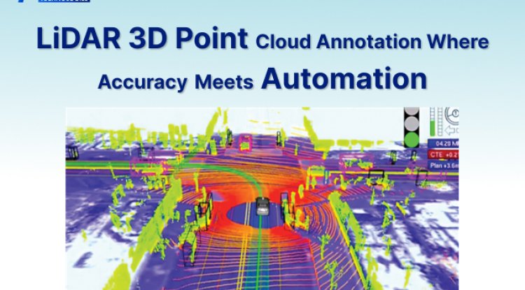
LiDAR 3D Point Cloud Annotation Where Accuracy Meets Automation #annotation #lidardata #lidarpointcloudannotation @LandSurveyorsU @esriuk #lidar @lidarnews @LiDARLatam blog.polosoftech.com/lidar-3d-point…
One scan = hundreds of measurement points. SLAM Scan delivers exact 3D data for accurate quoting, faster installs, and fewer costly errors. We help builders, engineers, architects & more. #LiDARData #ProjectPlanning #3DScanning
Forests play a vital role in maintaining the Earth’s ecological balance, supporting biodiversity, and combating climate change. #LiDARData #LiDARCLassification #TreeClassification #ForestClassification blog.polosoftech.com/tree-point-and…
#OrthophotoGeneration: Accuracy from Every Angle! Orthophoto generation ensures precision, scale, & reliability for diverse applications in mapping, planning, and analysis. polosoftech.com/lidar-drafting… #OrthophotoGeneration #LiDARData #LiDARClassification #AerialImaging #RemoteSensing
Transform LiDAR point clouds into stunning visuals! Overlay images and colourize your point clouds to bring data to life. polosoftech.com/lidar-drafting… #LiDARData #GISMapping #PointClouds #ImageOverlay #DataVisualization #InnovationInTech #Polosoft #Colorizing #mesmerizing
🚨 New data alert! 🚨 Explore our latest Northland LiDAR data, now live on the LDS! 🌍✨ Dive into the DEM, DSM, and point cloud, and check out this stunning vis of Port Whangarei made with the 1m DSM and aerial imagery. #LiDARData #Northland #GIS 🔗data.linz.govt.nz/layer/d3TxZSZ2…
Meanders are nature’s art, reshaping entire landscapes. 🌊✨ This REM of the Humboldt River was made using lidar data from the USGS, processed in QGIS, and rendered in Blender. #GIS #Blender3D #LidarData #HumboldtRiver #DataViz #Map #Mapping
Thrilled to announce that my 1st PhD chapter on data fusion for canopy cover mapping in Florida has just been published! 🎊🌲📡 Check it out here: mdpi.com/3138712 #RemoteSensing #Forestry #LiDARdata
Reach out to us for your image overlay colourization project work. Polosoft’s image overlay colourization combines LiDAR’s precision with enhanced visualization, making complex data easier to interpret. tinyurl.com/5n76fvsf #LiDARData #ImageOverlayColourization #lidar
Accurate #terrainmodelling starts with quality breakline and contour generation using #LiDARdata. Enhance your topographic insights and turn raw #LiDAR data into actionable #3Dmodels. t.ly/7wGp6 #Breakline #Contourgeneration #LiDARDataAnalysis #LiDARDataProcessing
🙌New data alert! Dive into our latest Waikato LiDAR data, with the DEM, DSM, and point cloud live on the LDS now. Check out this vis of Paeroa made with the 1m DSM and aerial imagery from the LDS! 🌍✨data.linz.govt.nz/layer/120347-w… (Image: Waikato) #opendata #LidarData #Waikato #GIS
Next-level #LiDARdataprocessing and mapping to give you a precise, 3D view of your project site. Combined with our expert survey data processing, make confident decisions for your project. Contact us! bit.ly/3AhjjiZ #lidarmapping #lidardata #lidarclassification

Want to learn more about the LIDAR drone landscape? Make sure to visit @Wingtra's new LIDAR drone page, where you can find useful guides on navigating the world of LIDAR data capture. #droneallianceeurope #DroneLIDAR #LIDARdata #dronetech #dronesforgood #Wingtra

Good, reliable, fast drone LIDAR data comes at a cost, and it should. But what you actually pay for it in terms of field time, processing time, training time really depends on the quality of your system. Learn more about this on our new LIDAR drone page: hubs.la/Q02tl1wg0
Struggling with noisy point-cloud data? Discover the advanced voxel-based triangulation tool, HD Mesh Construction, in Geomagic Wrap version 2021: youtube.com/watch?v=6plxmS… #GeomagicWrap #HDmesh #LidarData #Oqton


🙌New data alert! Dive into our latest Waikato LiDAR data, with the DEM, DSM, and point cloud live on the LDS now. Check out this vis of Paeroa made with the 1m DSM and aerial imagery from the LDS! 🌍✨data.linz.govt.nz/layer/120347-w… (Image: Waikato) #opendata #LidarData #Waikato #GIS
Meanders are nature’s art, reshaping entire landscapes. 🌊✨ This REM of the Humboldt River was made using lidar data from the USGS, processed in QGIS, and rendered in Blender. #GIS #Blender3D #LidarData #HumboldtRiver #DataViz #Map #Mapping
Struggling with noisy point-cloud data? Discover the advanced voxel-based triangulation tool, HD Mesh Construction, in Geomagic Wrap version 2021: youtube.com/watch?v=6plxmS… #GeomagicWrap #HDmesh #LidarData #Oqton
🚨 New data alert! 🚨 Explore our latest Northland LiDAR data, now live on the LDS! 🌍✨ Dive into the DEM, DSM, and point cloud, and check out this stunning vis of Port Whangarei made with the 1m DSM and aerial imagery. #LiDARData #Northland #GIS 🔗data.linz.govt.nz/layer/d3TxZSZ2…
Thrilled to announce that my 1st PhD chapter on data fusion for canopy cover mapping in Florida has just been published! 🎊🌲📡 Check it out here: mdpi.com/3138712 #RemoteSensing #Forestry #LiDARdata
Not only can Global Mapper Pro import and export lidar data, this data can be visualized in 2D and 3D viewers by a number of the data attributes. Learn about attributes in #lidardata in this infographic! #GlobalMapper #RemoteSensing #Lidar
Forests play a vital role in maintaining the Earth’s ecological balance, supporting biodiversity, and combating climate change. #LiDARData #LiDARCLassification #TreeClassification #ForestClassification blog.polosoftech.com/tree-point-and…
Transform LiDAR point clouds into stunning visuals! Overlay images and colourize your point clouds to bring data to life. polosoftech.com/lidar-drafting… #LiDARData #GISMapping #PointClouds #ImageOverlay #DataVisualization #InnovationInTech #Polosoft #Colorizing #mesmerizing
Accurate #terrainmodelling starts with quality breakline and contour generation using #LiDARdata. Enhance your topographic insights and turn raw #LiDAR data into actionable #3Dmodels. t.ly/7wGp6 #Breakline #Contourgeneration #LiDARDataAnalysis #LiDARDataProcessing
Next-level #LiDARdataprocessing and mapping to give you a precise, 3D view of your project site. Combined with our expert survey data processing, make confident decisions for your project. Contact us! bit.ly/3AhjjiZ #lidarmapping #lidardata #lidarclassification
#OrthophotoGeneration: Accuracy from Every Angle! Orthophoto generation ensures precision, scale, & reliability for diverse applications in mapping, planning, and analysis. polosoftech.com/lidar-drafting… #OrthophotoGeneration #LiDARData #LiDARClassification #AerialImaging #RemoteSensing
Reach out to us for your image overlay colourization project work. Polosoft’s image overlay colourization combines LiDAR’s precision with enhanced visualization, making complex data easier to interpret. tinyurl.com/5n76fvsf #LiDARData #ImageOverlayColourization #lidar
Something went wrong.
Something went wrong.
United States Trends
- 1. Good Sunday 76.9K posts
- 2. #AskFFT N/A
- 3. Klay 35.2K posts
- 4. #sundayvibes 6,422 posts
- 5. Full PPR N/A
- 6. Raora 3,142 posts
- 7. Ja Morant 16.4K posts
- 8. #AskBetr N/A
- 9. #FelizCumpleañosNico 6,106 posts
- 10. Cornbread 1,510 posts
- 11. McLaren 144K posts
- 12. Sunday Funday 3,009 posts
- 13. Beirut 11.4K posts
- 14. Kamara 1,601 posts
- 15. Tuten 1,369 posts
- 16. Michael Wilson N/A
- 17. Leeds 15.3K posts
- 18. #FelizCumpleañosPresidente 4,951 posts
- 19. Pick 2 18.2K posts
- 20. Who Dey 9,010 posts