#mapserver search results

#Mapserver - lightning-fast open source web mapping new release 8.2.0! many thanks to all who were involved! mapserver.org/development/ch…


Update: MapServer 8.2.0 verfügbar! / Update: MapServer 8.2.0 available! geoobserver.de/2024/07/10/upd… via @sven_s8 #mapserver #gistribe #gischat #fossgis #foss4g #OSGeo #spatial #geospatial #opensource #mapping #gis #geo #geoObserver pls RT


MapServer: v8.4.0 released! geoobserver.de/2025/01/21/map… via @mapserving #mapserver #gistribe #gischat #fossgis #foss4g #OSGeo #spatial #geospatial #opensource #mapping #gis #geo #geoObserver pls RT


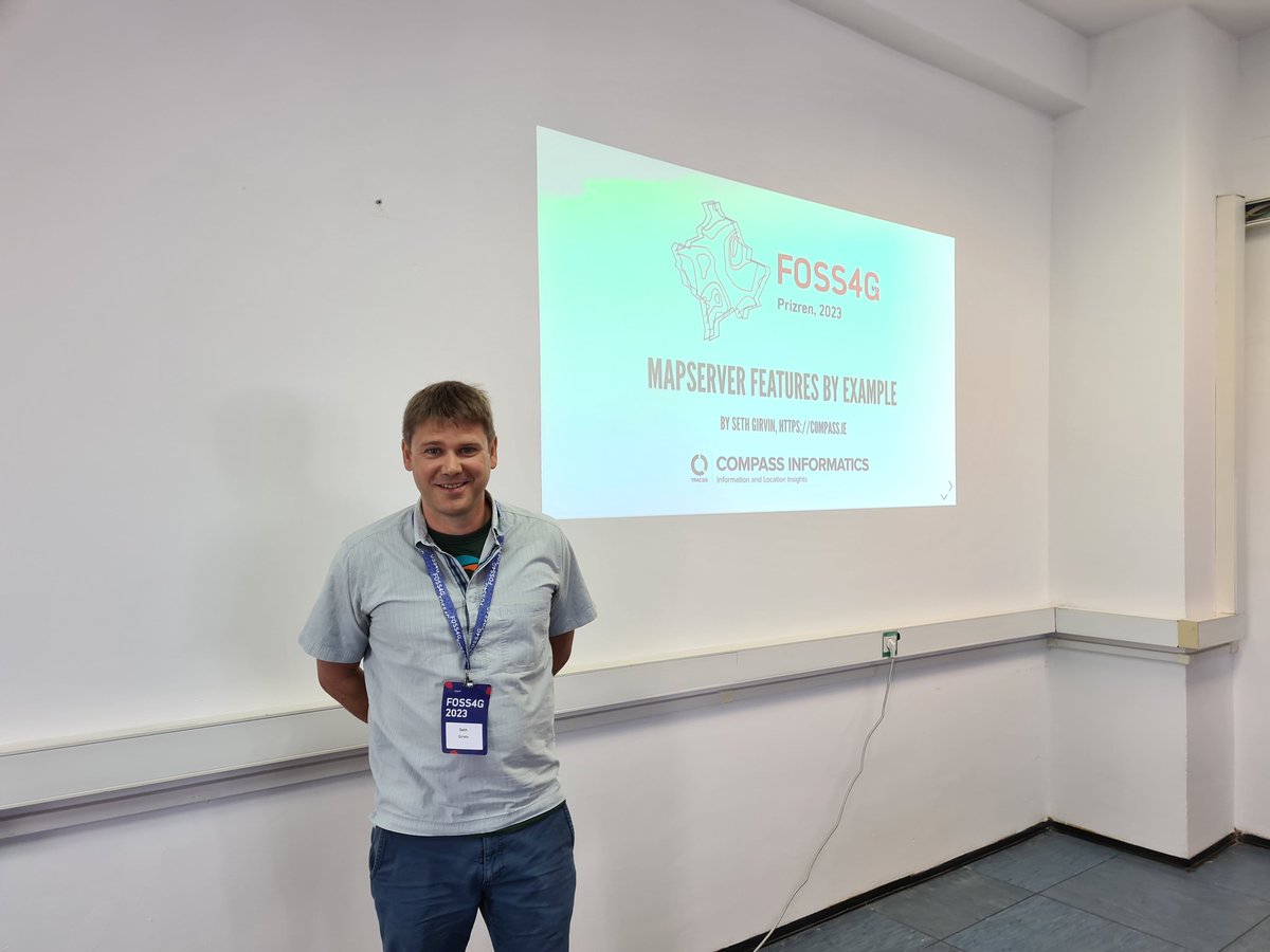
Join us at #FOSS4G2023! @geographika is talking about #MapServer Features by Example #osgeo @mapserver_osgeo

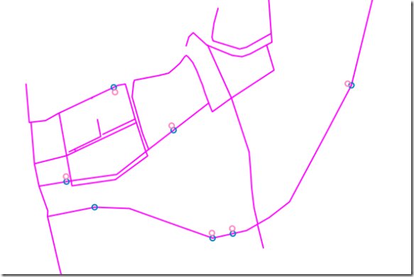
#FOSS4G2023 talk on #MapServer Mapfiles by Example accepted! 34 lines to create the following contour map

📣 Just deployed a new update - the editor now supports code-folding for Mapfiles. Enjoy a better coding experience with this handy feature! #Mapfiles #MapServer
Over 3,000 fonts now available in #MapServer Studio. A couple of changes to a Mapfile can produce very different maps.


📢 Formation Mapserver 🌍 🚀 Notre nouveau service : Formation MapServer – Initiation sur 2 Jours 📅2j 📍 Sur site ou à distance 📋 Programme : clast.tech/produit/format… 🏙 #qgis #mapserver #geomatique️🏡 🔗 Inscription : contact(at)clast.tech


✨ NEW FEATURE ALERT ✨ layered.earth - Basic support for ESRI MapServers - Identify queries to understand the data behind the raster pixels - Explore the MapServer legend #geospatial #esri #mapserver #geo #Datavisualization
Updated: Mapserver 8.0.1 geoobserver.wordpress.com/2023/05/26/upd… #MapServer #fossgis #osgeo #foss4g #gistribe #gischat ##opensource #spatial #geospatial #mapping #gis #geo #geoObserver via @mapserver_osge

Smooth geometry using MapServer's smoothsia function app.mapserverstudio.net/#iSCZaMdN #mapserver #geospatial

Das Flächenportal für Erneuerbare Energien in Rheinland-Pfalz ist jetzt live! Technisch basiert das Portal vollständig auf Open-Source-Technologien. #Postgis #Mapserver #Openlayers #Windenergie #RLP fpee.rlp.de
Browse the Natural Earth datasets available in MapServer Studio via the new OGC Features API with a custom theme at api-staging.mapserverstudio.net/mapserver/natu… #mapserver #ogc


An example of displaying #GeoJSON inline in a #MapServer Mapfile - app.mapserverstudio.net/#si9derCc

#MapServer halftone map - full source at app.mapserverstudio.net/#2gqakUD_ inspired by the post at snailbones.medium.com/halftone-bathy…


Explore o fascinante universo FOSS4G com a palestra de Jeff McKenna sobre MapServer e MS4W! 🌐 Descubra como o código aberto está revolucionando a geoespacialização. Assista agora: youtu.be/6dLhy6VequM #FOSS4G #Geoespacialização #MapServer #MS4W #Inovação #Geolocalização 🚀

📢 Formation Mapserver 🌍 🚀 Notre nouveau service : Formation MapServer – Initiation sur 2 Jours 📅2j 📍 Sur site ou à distance 📋 Programme : clast.tech/produit/format… 🏙 #qgis #mapserver #geomatique️🏡 🔗 Inscription : contact(at)clast.tech
MapServer: v8.4.0 released! geoobserver.de/2025/01/21/map… via @mapserving #mapserver #gistribe #gischat #fossgis #foss4g #OSGeo #spatial #geospatial #opensource #mapping #gis #geo #geoObserver pls RT
Das Flächenportal für Erneuerbare Energien in Rheinland-Pfalz ist jetzt live! Technisch basiert das Portal vollständig auf Open-Source-Technologien. #Postgis #Mapserver #Openlayers #Windenergie #RLP fpee.rlp.de
Update: MapServer 8.2.2 verfügbar! / Update: MapServer 8.2.2 available! geoobserver.de/2024/09/03/upd… #mapserver #gistribe #gischat #fossgis #foss4g #OSGeo #spatial #geospatial #opensource #mapping #gis #geo #geoObserver pls RT

Update: MapServer 8.2.0 verfügbar! / Update: MapServer 8.2.0 available! geoobserver.de/2024/07/10/upd… via @sven_s8 #mapserver #gistribe #gischat #fossgis #foss4g #OSGeo #spatial #geospatial #opensource #mapping #gis #geo #geoObserver pls RT
#Mapserver - lightning-fast open source web mapping new release 8.2.0! many thanks to all who were involved! mapserver.org/development/ch…
If you're interested in attending a brand new #MapServer workshop at @foss4ge please vote at talks.osgeo.org/foss4g-europe-… - FlatGeobuf, S3 buckets, vector tiles and more!
An example of displaying #GeoJSON inline in a #MapServer Mapfile - app.mapserverstudio.net/#si9derCc
✨ NEW FEATURE ALERT ✨ layered.earth - Basic support for ESRI MapServers - Identify queries to understand the data behind the raster pixels - Explore the MapServer legend #geospatial #esri #mapserver #geo #Datavisualization
Explore o fascinante universo FOSS4G com a palestra de Jeff McKenna sobre MapServer e MS4W! 🌐 Descubra como o código aberto está revolucionando a geoespacialização. Assista agora: youtu.be/6dLhy6VequM #FOSS4G #Geoespacialização #MapServer #MS4W #Inovação #Geolocalização 🚀


Released: #MapServer 7.2.0 geoobserver.wordpress.com/2018/07/31/rel… via @mapserver_osgeo #gis #geo #geospatial #geoObserver #gistribe

3x Released: #MapServer, #GeoServer, #GRASS geoobserver.wordpress.com/2019/12/17/3x-… #gis #geo #oss #fossgis #gistribe #spatial #geoobserver
Neue Versionen: #MapServer und #GDAL new versions geoobserver.wordpress.com/2017/05/11/neu… #mapserver #gdal #oss #fossgis #geo #GIS #geoObserver


#MapServer 7.0 is out! Download: mapserver.org/download.html New features: mapserver.org/development/an…


Packed room of #osgeo devs hard at work at #viennacodesprint14 #mapserver #qgis #grass #gdal #postgis #ol #LAS etc


Webinar #Geoserver : les principaux serveurs cartographiques #opensource #mapserver #Geoserver et #QGIS Server

Update: MapServer 8.2.0 verfügbar! / Update: MapServer 8.2.0 available! geoobserver.de/2024/07/10/upd… via @sven_s8 #mapserver #gistribe #gischat #fossgis #foss4g #OSGeo #spatial #geospatial #opensource #mapping #gis #geo #geoObserver pls RT

Little bit more about ScribeUI / Quelques observations sur ScribeUI #mapserver simonmercier.net/blog/?p=1937


Installer MapServer sous linux tutorielgeo.com/mapserver-tuto… #Mapserver #gis #geomatics #Qgis #geoinformatics #opensource #datascience #opendata #Geospatial

#mapserver #geoserver #openlayers #postgis #qgis #mapbender - The #OSGEO universe in #github ekisto.sq.ro


Just finished our #3D workshop for @foss4g on opensource GIS 3D stack, with #PostGIS, #MapServer, #Cardano #OSGeo

View of the #MapServer and @ZOO_Project code sprint teams today at #foss4ge Paris. Proud members of the @OSGeo family!


Offset points in #Mapserver and #PostGIS #linear referencing mapoholic.wordpress.com/2018/08/18/off…

#30DayMapChallenge - Day 7 - raster Multi-week time series of #HRRR surface smoke created using collection of rasters generated by #MapServer. Video link: postholer.com/portfolio/imag…


MapServer: v8.4.0 released! geoobserver.de/2025/01/21/map… via @mapserving #mapserver #gistribe #gischat #fossgis #foss4g #OSGeo #spatial #geospatial #opensource #mapping #gis #geo #geoObserver pls RT
profile: @ZoltanSiki has been using #MapServer since first compiling version 3.4 from source in the 90's! At the #foss4ge code sprint


Something went wrong.
Something went wrong.
United States Trends
- 1. Grammy 203K posts
- 2. Clipse 12.3K posts
- 3. Kendrick 48.8K posts
- 4. olivia dean 10.7K posts
- 5. Dizzy 8,322 posts
- 6. addison rae 17K posts
- 7. gaga 85.4K posts
- 8. #FanCashDropPromotion 3,229 posts
- 9. Leon Thomas 13.3K posts
- 10. Katseye 93.1K posts
- 11. AOTY 15.5K posts
- 12. ravyn lenae 2,038 posts
- 13. Kehlani 28.4K posts
- 14. lorde 10.2K posts
- 15. Album of the Year 50.3K posts
- 16. Durand 4,074 posts
- 17. #FridayVibes 6,517 posts
- 18. Luther 21.1K posts
- 19. Alfredo 2 N/A
- 20. The Weeknd 9,046 posts