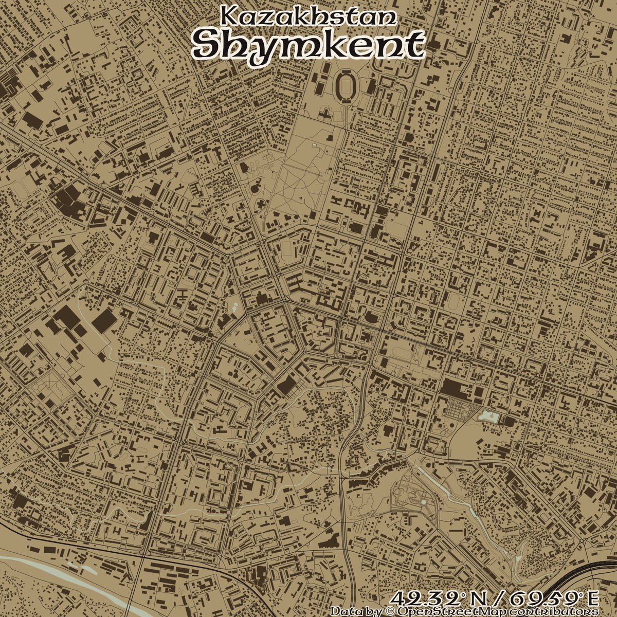
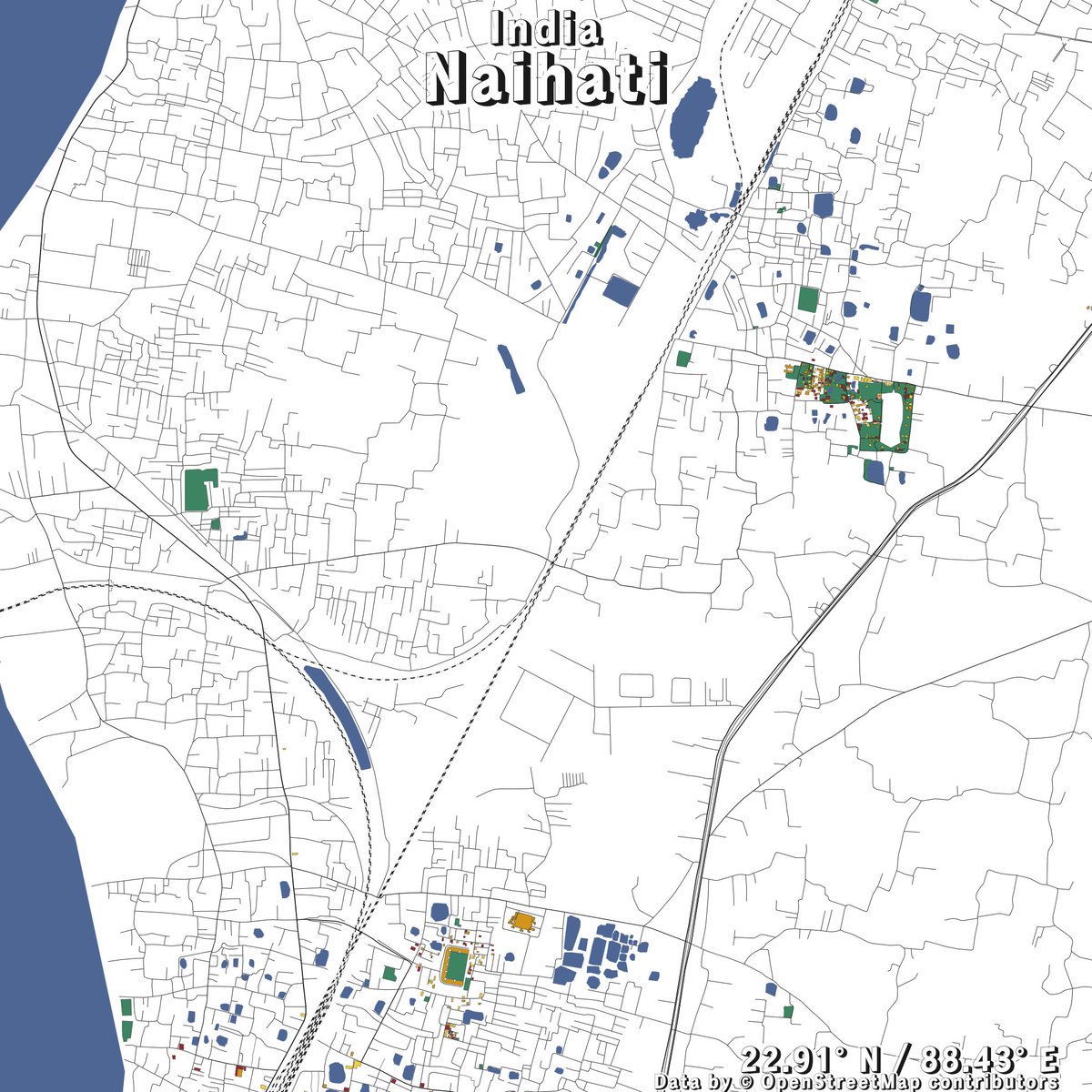
#openstreetmap نتائج البحث

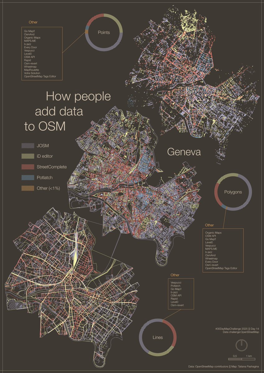
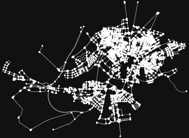
#30DayMapChallenge Day 14 – Data challenge: #OpenStreetMap A #map showing how people add data to OSM, using Geneva as an example. #JOSM, #iDeditor and #StreetComplete create visible patterns on the map🖌️🎨 And there are plenty of other apps to choose from😉📱💻🤖🗺️

¡Comunidad OSM Latam y del mundo entero, Ciudad de México y su Día de Muertos, les espera con muchísimo cariño y ansias por compartir y mapear juntos en comunidad! ¡Nos vemos en CDMX! #OSMLatam #SotMLatam2026 #OpenStreetMap #Mexico


Creando mapas con 𝙘𝙖𝙧𝙩𝙤𝙜𝙧𝙖𝙥𝙝𝙧 en #R 𝙘𝙖𝙧𝙩𝙤𝙜𝙧𝙖𝙥𝙝𝙧 facilita enormemente la creación de mapas atractivos y funcionales en R, evitando la necesidad de realizar consultas complejas a #OpenStreetMap mappinggis.com/2025/10/creand…


と言う訳で、万博の大規模マッピングはこれで最後。 ドイツとルクセンブルク館の形状を修正、大屋根リングの通路を整えて正確性を向上。まだまだ描ける所は山積みだけど、この半年間頑張ったと思う。誰か褒めてください(笑) #OpenStreetMap #EXPO2025 #大阪・関西万博


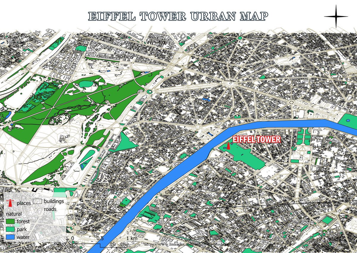
🌇 Day 14 Theme: OpenStreetmap The map presented today illustrates the urban landscape of Paris, renowned as the city of love, with the iconic Eiffel Tower situated at its center. 🖥️ Tool used: QGIS 📍 Data: Openstreetmap #30DayMapChallenge #Day14 #Openstreetmap

🗺️A Minimalistic 3D Map of Central Park 🏞️ in Manhattan, New York City 🇺🇸 made using the Highest Hit DSM (2017) from the New York GIS Clearinghouse, overlaid with #OpenStreetMap #centralpark #nyc #USA #America #gischat #Cartography #dataviz #b3d #blender #NYCOpenData


#30DayMapChallenge 🗺️, jour 14 : #OpenStreetMap. Avec parfois des données insoupçonnées. Voici le parcours du Transcorrézien, un ancien tramway à vapeur rural (en Corrèze, donc), dont il reste quelques vestiges... 🚂


¿Qué tanto es tantito? #OpenStreetMap es una increíble herramienta donde miles de mapeadores voluntarios alrededor de mundo plasman cada detalle. Aquí un excelente ejemplo en la #CDMX. Hospital General de México: ⬅️Mayo 2025 ➡️Octubre 2025


地域を歩きながらウィキペディア記事を確認できるマップアプリ「WikiWalk」を作成しました! ウィキペディアタウンの役に立てばと思って作りました。 ↓から利用できます。 wiki-walk.vercel.app 足りていないことも多いと思うので指摘いただけると助かります #wikipediatown #OpenStreetMap
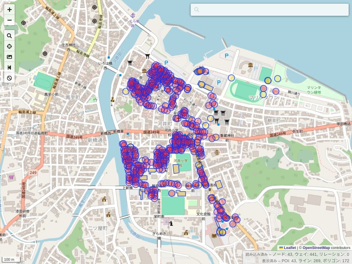
今日は能登半島の輪島市へ。レンタサイクルで回りつつ、建物の倒壊状況を記録。3時間みっちり作業して、朝市は1/3ほど更新したけど、まだまだ不十分。 来年の春にも行こうと思いつつ、誰かに頼まれた訳でも、仕事でも無いのに、何故行くんだろう。自分でも少し不思議な気持ち。 #OpenStreetMap


Lo que pienso cuando alguien me pregunta "¿cómo se hace para que Google muestre el nombre correcto de mi calle?" Usen mapas buenos, usen #OpenStreetMap

Trials maps of my local town using the new #openstreetmap vector tiles shortbread-tiles.org/schema/1.0/ in #qgis. It's possible to generate this for any other location. Feel free to request. © OpenStreetMap Contributors. Contours using NASADEM


Here is Barcelona🇻🇪, the capitol of Anzoategui state. The city was established in 1671 by settlers from the Spanish region of Catalonia, and they named it after their home city of Barcelona, Spain. Which city should I do next? #OpenStreetMap🗺 #CityMaps🏙 #R📊 #RStudio💻

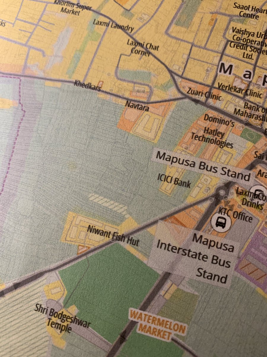
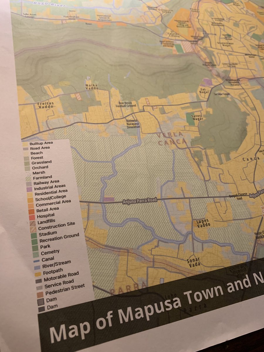
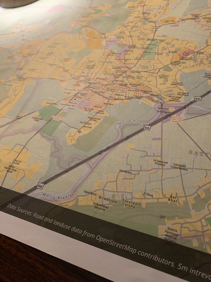
Being next door to a good printer has been fun. First trial of an A2 size color print. Costed Rs150 ($2) at Mapusa, #Goa. Tried including individual parcel boundaries with 0.1mm width and it printed fine 🤯 Map designed in #qgis using #openstreetmap data.


無料の商業アプリがユーザー情報を集めたいのはビジネスとして理解できる。自分もGoogleMapをめちゃ頼ってます。一方でこの点でユーザーには選択肢があるってことを知っておくのも良いと思う。OSMというものがあることも含めて #OpenStreetMap

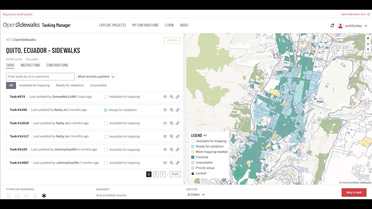
#OpenStreetMap es una tecnología de datos abiertos que permite iniciativas maravillosas como OpenSidewalks wiki.openstreetmap.org/wiki/OpenSidew… espero poder sumar data de accesibilidad universal para #PCD #a11y #dlscreativa
Fuentes: Natural Earth: naturalearthdata.com Conicet: mendoza.conicet.gov.ar/hora-oficial-h… Base: #OpenStreetMap

記事を投稿しました! Automating GIS Processes 2024 写経 Lesson 6 Network analysis in Python(2) qiita.com/t_t_japan/item… #Qiita #openstreetmap #GIS

Fuente: geonode.pergamino.gob.ar/catalogue/#/da… Base: #OpenStreetMap
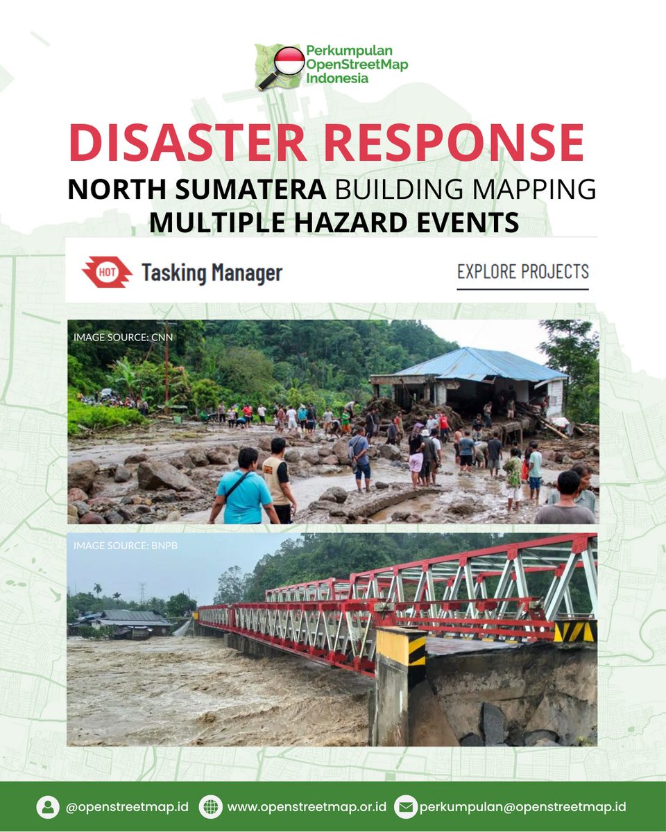
Bencana banjir, longsor, dan angin puting beliung pada Rabu, 26 Nov 2025 melanda 12 wilayah di Sumut. Yuk bantu pemetaan bangunan terdampak melalui OpenStreetMap. 🔗 task.hotosm.org 🔍 Project: #36537 & #36538 #SumutBersama #DisasterResponse #OpenStreetMap #HOTOSM

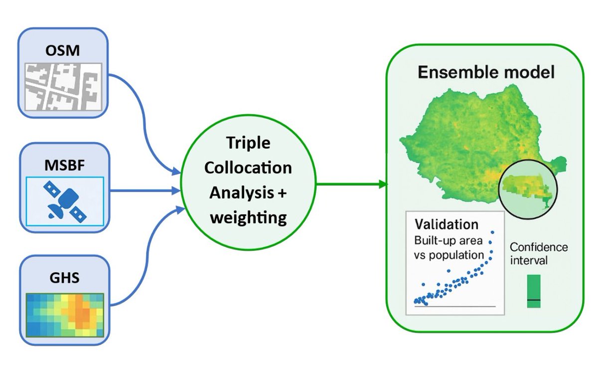
📢New Publication Built-Up Surface Ensemble Model for Romania Based on #OpenStreetMap, Microsoft Building Footprints, and Global Human Settlement Layer Data Sources Using Triple Collocation Analysis By Zsolt Magyari-Sáska and Ionel Haidu 👉mdpi.com/2220-9964/14/1…

OSM Daily Stats 📊 Users: 10,049,098 👥 Users that... edited nodes: 5,693 ✏️ uploaded GPX: 184 🗺️ Top 3 editors: 1. Wilmer - 40,398 🥇 2. FajrAl - 29,311 🥈 3. jptolosa - 27,752 🥉 Report run at 2025-11-27 00:00:16 UTC #OSMstats #OSM #OpenStreetMap

#MostCited Residential Micro-Segregation and Social Capital in Lima, Peru ✍️ by Fernando Calderón-Figueroa 👉 brnw.ch/21wXRPc #urban #OpenStreetMap
OSM Daily Stats 📊 Users: 10,048,147 👥 Users that... edited nodes: 5,720 ✏️ uploaded GPX: 152 🗺️ Top 3 editors: 1. dmich9 - 1,183,137 🥇 2. LuxuryCoop - 59,544 🥈 3. Vonter - 51,802 🥉 Report run at 2025-11-26 00:00:17 UTC #OSMstats #OSM #OpenStreetMap


Aunque parezca mentira la foto, son calles reales de #Zaragoza, las puedes ver en #OpenStreetMap openstreetmap.org/?mlat=41.63885…

OSM Daily Stats 📊 Users: 10,046,789 👥 Users that... edited nodes: 5,832 ✏️ uploaded GPX: 194 🗺️ Top 3 editors: 1. romik80 - 72,528 🥇 2. Wilmer - 59,566 🥈 3. w_djatmiko - 45,568 🥉 Report run at 2025-11-25 00:00:15 UTC #OSMstats #OSM #OpenStreetMap


#30DayMapChallenge Day 14 – Data challenge: #OpenStreetMap A #map showing how people add data to OSM, using Geneva as an example. #JOSM, #iDeditor and #StreetComplete create visible patterns on the map🖌️🎨 And there are plenty of other apps to choose from😉📱💻🤖🗺️

#30DayMapChallenge Day.1 - Points お題の'Point'に岬という意味があるらしいので、 岬に関連する地名(岬・崎/埼)を地図上で色分けしてみました。 データ元は #OpenStreetMap です。


Hace un rato en el @flisol_bogota hablando de mapeo abierto, proyectos colaborativos, el valor de la comunidad #OpenStreetMap y la importancia del mapa como herramienta de transformación social.


と言う訳で、万博の大規模マッピングはこれで最後。 ドイツとルクセンブルク館の形状を修正、大屋根リングの通路を整えて正確性を向上。まだまだ描ける所は山積みだけど、この半年間頑張ったと思う。誰か褒めてください(笑) #OpenStreetMap #EXPO2025 #大阪・関西万博
🌇 Day 14 Theme: OpenStreetmap The map presented today illustrates the urban landscape of Paris, renowned as the city of love, with the iconic Eiffel Tower situated at its center. 🖥️ Tool used: QGIS 📍 Data: Openstreetmap #30DayMapChallenge #Day14 #Openstreetmap
今日は能登半島の輪島市へ。レンタサイクルで回りつつ、建物の倒壊状況を記録。3時間みっちり作業して、朝市は1/3ほど更新したけど、まだまだ不十分。 来年の春にも行こうと思いつつ、誰かに頼まれた訳でも、仕事でも無いのに、何故行くんだろう。自分でも少し不思議な気持ち。 #OpenStreetMap
#30DayMapChallenge 🗺️, jour 14 : #OpenStreetMap. Avec parfois des données insoupçonnées. Voici le parcours du Transcorrézien, un ancien tramway à vapeur rural (en Corrèze, donc), dont il reste quelques vestiges... 🚂
Creando mapas con 𝙘𝙖𝙧𝙩𝙤𝙜𝙧𝙖𝙥𝙝𝙧 en #R 𝙘𝙖𝙧𝙩𝙤𝙜𝙧𝙖𝙥𝙝𝙧 facilita enormemente la creación de mapas atractivos y funcionales en R, evitando la necesidad de realizar consultas complejas a #OpenStreetMap mappinggis.com/2025/10/creand…
🗺️A Minimalistic 3D Map of Central Park 🏞️ in Manhattan, New York City 🇺🇸 made using the Highest Hit DSM (2017) from the New York GIS Clearinghouse, overlaid with #OpenStreetMap #centralpark #nyc #USA #America #gischat #Cartography #dataviz #b3d #blender #NYCOpenData
満場で万博入れないからOSMの万博マッピング中。今でもそこそこ精度はあるけど、将来に渡って活用されるので、もう一段階精度を上げたり情報追加を行っておきたい所。まぁ、体力と気力的に限界あるので、無理しない範囲で頑張ろうー。 #OpenStreetMap

Now I started crafting 3D city maps and my first one is from Caracas🇻🇪. Thanks to @openstreetmap for the buildings, roads, parks, and water layers. Which city should I do next? #OpenStreetMap🗺 #CityMaps🏙 #R📊 #RStudio💻

¿Qué tanto es tantito? #OpenStreetMap es una increíble herramienta donde miles de mapeadores voluntarios alrededor de mundo plasman cada detalle. Aquí un excelente ejemplo en la #CDMX. Hospital General de México: ⬅️Mayo 2025 ➡️Octubre 2025


Here is Barcelona🇻🇪, the capitol of Anzoategui state. The city was established in 1671 by settlers from the Spanish region of Catalonia, and they named it after their home city of Barcelona, Spain. Which city should I do next? #OpenStreetMap🗺 #CityMaps🏙 #R📊 #RStudio💻
Lo que pienso cuando alguien me pregunta "¿cómo se hace para que Google muestre el nombre correcto de mi calle?" Usen mapas buenos, usen #OpenStreetMap


Something went wrong.
Something went wrong.
United States Trends
- 1. Ravens 53.6K posts
- 2. Ravens 53.6K posts
- 3. Ravens 53.6K posts
- 4. Lamar 42.7K posts
- 5. Joe Burrow 18K posts
- 6. Zay Flowers 3,849 posts
- 7. #WhoDey 3,289 posts
- 8. Cowboys 88.9K posts
- 9. Derrick Henry 4,293 posts
- 10. Zac Taylor 2,556 posts
- 11. Perine 1,495 posts
- 12. Harbaugh 2,812 posts
- 13. #CINvsBAL 2,550 posts
- 14. AFC North 2,125 posts
- 15. #heatedrivalry 5,910 posts
- 16. Mahomes 32.8K posts
- 17. Sarah Beckstrom 194K posts
- 18. Tanner Hudson 1,233 posts
- 19. Cam Boozer 2,029 posts
- 20. Chase Brown 2,663 posts