#postgis resultados da pesquisa

Aprende a crear #Geoportales (Dashboard o Tableros) desde cero con IA, almacena los datos en la nube con la capacidad de #PostGIS, actualiza las capas desde #QGIS y obtén tu propia URL pública. Sin pagar por el uso de ningún software. udemy.com/course/curso-t… #Github #ChatGPT…

Elevate Your GIS Skills with PostgreSQL + #PostGIS: The Professional’s Vector Data Backbone If you’re still managing your vector GIS data through scattered shapefiles, ad-hoc folders, or aging file geodatabases… it’s time for a serious upgrade. Modern GIS work demands…

#Postgis is a fantastic software, since my first steps in 2005 I use postgis daily at work for all steps of geodata management and processing. Many thanks to all involved and happy #postgisday ! #dalle3art


Generate tiles directly from your database using #PostGIS`s ST_AsMVT and ST_AsMVTGeom functions. Connecting to the database via the intuitive GUI in MapTiler Server is really easy too. (Advanced users can still use SQL if they want!) Learn more: bit.ly/4arUpuu #WebMaps

PostGIS Day is packed with talks from geospatial industry leaders ... where else can you find @Snowflake, @CARTO, @wherobots, @BuntingLabs, @felt, @openstreetmap all together? Join us Thursday, Nov 20. Reg and full schedule: snowflake.com/postgis-day-20… #PostGIS


Using PostGIS ST_LineInterpolatePoints to evenly get points from road features, ST_ClusterDBSCAN to get non-overlapping points for road shields on interactive map. Only ST_ClusterDBSCAN for non-overlaping GNIS place names. #30DayMapChallenge #points #postgis #leafletjs


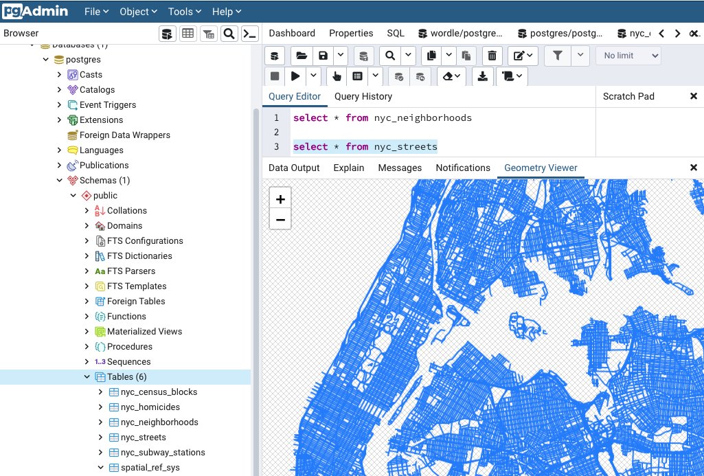
Those little red and blue dots might not look like much, but they are signs that a plan is coming together on this demo #PostgreSQL database with #PostGIS 🎉🐘


🚀Join our Introduction to PostGIS course and unlock the Power of Spatial Databases! 📷27–28 October 2025 Gain the tools to manage geospatial data with confidence and precision 🔗Book your spot: kartoza.com/training/intro… #Kartoza #PostGIS #OpenSource #GIS #SpatialAnalysis


Cómo conectar #QGIS con #PostGIS en 7 sencillos pasos rviv.ly/E6f02b

#PostgreSQL + PostGIS: Solución para la gestión de Datos Espaciales rviv.ly/XWiGcd #PostGIS

Ensure a smooth transition as you upgrade to #PostGIS by mastering advanced #PostgreSQL administration, Linux container management, and rigorous validation techniques. 📺 👀 Watch the on-demand webinar here: bit.ly/3R81Qjs


PostGIS 3.6 – تنظيف البيانات المكانية 🚀 دالة ST_CoverageClean & Co تساعد على تنظيف وبناء الطبقات المكانية بدقة عالية، مما يضمن تحليلاً جغرافيًا خاليًا من الأخطاء الهندسية. 🌍📊 🔗 التفاصيل: geoobserver.de/2025/08/29/st_… #GIS #PostGIS #geospatial #opensource #spatial #geoObserver


🚀 Join Ryan Lambert for a full-day pre-con focusing on #PostGIS, a powerful #PostgreSQL extension that brings geospatial data into a familiar relational environment. Learn more and register now at rd.gt/45rGrpa.

PostGIS-Release: 3.4.3 geoobserver.de/2024/09/05/pos… #PostGIS #PostgreSQL #gistribe #gischat #fossgis #foss4g #OSGeo #spatial #geospatial #opensource #gis #geo #geoObserver pls RT @postgis @pwramsey

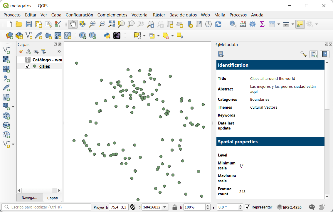
PgMetadata: #metadatos en QGIS para capas #PostGIS 🐘 rviv.ly/c4DAQ3 #PostgreSQL
We are at @foss4gna all week! Come by the Crunchy Data table for some special edition stickers and catch our team giving a number of talks. Elizabeth Garrett Christensen @sqlliz has a talk at 11:30 Tuesday about "Postgres and #PostGIS Ops Management" and 1:00 Wednesday about…

Cómo leer y grabar datos en #PostGIS desde #GeoPandas mappinggis.com/2023/09/como-l… #Python

🌐🐘➡ En esta entrada se habla de la importancia de saber SQL a la hora de trabajar con bases de datos como 𝗣𝗼𝘀𝘁𝗴𝗿𝗲𝗦𝗤𝗟 o 𝗣𝗼𝘀𝘁𝗚𝗜𝗦. Sigue leyendo: bit.ly/BBDD_saber-SQL #basededatos #SIG #PostGIS #SQL #PostgreSQL
Elevate Your GIS Skills with PostgreSQL + #PostGIS: The Professional’s Vector Data Backbone If you’re still managing your vector GIS data through scattered shapefiles, ad-hoc folders, or aging file geodatabases… it’s time for a serious upgrade. Modern GIS work demands…

20 nov. a.s #PostGIS-day, in Utrecht. Oók relevant voor #ArcGIS gebruikers. Waarom? lees het op gisnederland.nl #osgeonl #gisnl
PostGIS Day is packed with talks from geospatial industry leaders ... where else can you find @Snowflake, @CARTO, @wherobots, @BuntingLabs, @felt, @openstreetmap all together? Join us Thursday, Nov 20. Reg and full schedule: snowflake.com/postgis-day-20… #PostGIS
🌍🐘 Empieza el #curso que formará al alumno en el manejo de la 𝗯𝗮𝘀𝗲 𝗱𝗲 𝗱𝗮𝘁𝗼𝘀 𝗣𝗼𝘀𝘁𝗚𝗜𝗦 para obtener el mayor rendimiento de sus datos. 🌐 bit.ly/Curso_BBDD_Pos… 💻 Online 📅 13 de noviembre 🕘 120 horas ✅ Descuentos ℹ bit.ly/Form_BBDD_Post… #QGIS #PostGIS


Elevate Your GIS Skills with PostgreSQL + #PostGIS: The Professional’s Vector Data Backbone If you’re still managing your vector GIS data through scattered shapefiles, ad-hoc folders, or aging file geodatabases… it’s time for a serious upgrade. Modern GIS work demands…
Introducción a Express.js: conexión a una base de datos #PostGIS #JavaScript mappinggis.com/2024/03/introd…

#Postgis is a fantastic software, since my first steps in 2005 I use postgis daily at work for all steps of geodata management and processing. Many thanks to all involved and happy #postgisday ! #dalle3art


Working with large area dataset in #postgis might give incorrect measurements. How can we fix this? Thread 🧵 👇 #postgis #postgresql #gis #geospatial


Get a crash course in PostGIS for your spatial-database needs by attending this #FOSS4GNA workshop led by two #PostGIS pioneers: bit.ly/foss4gna2025 #GIS

Those little red and blue dots might not look like much, but they are signs that a plan is coming together on this demo #PostgreSQL database with #PostGIS 🎉🐘
Using PostGIS ST_LineInterpolatePoints to evenly get points from road features, ST_ClusterDBSCAN to get non-overlapping points for road shields on interactive map. Only ST_ClusterDBSCAN for non-overlaping GNIS place names. #30DayMapChallenge #points #postgis #leafletjs
🌐🗺️➡️ 𝗖𝗮𝗿𝘁𝗼 es una empresa que permite desde su plataforma trabajar con datos del usuario con el objetivo de ser mostrados en un visor cartográfico. Leer más: bit.ly/formatos_datos… #Carto #WebGIS #PostGIS

PostGIS-Release: 3.4.3 geoobserver.de/2024/09/05/pos… #PostGIS #PostgreSQL #gistribe #gischat #fossgis #foss4g #OSGeo #spatial #geospatial #opensource #gis #geo #geoObserver pls RT @postgis @pwramsey

La vista previa desde el administrador de bases de datos de #QGIS nos ahorra mucho tiempo para no tener que cargar cada una de las capas/tablas a nuestro editor. #PostGIS

PostGIS 3.6 – تنظيف البيانات المكانية 🚀 دالة ST_CoverageClean & Co تساعد على تنظيف وبناء الطبقات المكانية بدقة عالية، مما يضمن تحليلاً جغرافيًا خاليًا من الأخطاء الهندسية. 🌍📊 🔗 التفاصيل: geoobserver.de/2025/08/29/st_… #GIS #PostGIS #geospatial #opensource #spatial #geoObserver


We are at @foss4gna all week! Come by the Crunchy Data table for some special edition stickers and catch our team giving a number of talks. Elizabeth Garrett Christensen @sqlliz has a talk at 11:30 Tuesday about "Postgres and #PostGIS Ops Management" and 1:00 Wednesday about…
Ensure a smooth transition as you upgrade to #PostGIS by mastering advanced #PostgreSQL administration, Linux container management, and rigorous validation techniques. 📺 👀 Watch the on-demand webinar here: bit.ly/3R81Qjs

Learn how @clevemetroparks manage geospatial data using #GeoServer, #MapStore and #Postgis from our #free #webinar. Recording here 👉 wp.me/pcNkxY-2ss Slides here 👉bit.ly/clev-metro-sli… #FOSS4G #OSGEO #MapStore #GeoServer #gischat #conservation #localgov #opensource

🚀Join our Introduction to PostGIS course and unlock the Power of Spatial Databases! 📷27–28 October 2025 Gain the tools to manage geospatial data with confidence and precision 🔗Book your spot: kartoza.com/training/intro… #Kartoza #PostGIS #OpenSource #GIS #SpatialAnalysis
Something went wrong.
Something went wrong.
United States Trends
- 1. Good Wednesday 24.2K posts
- 2. #hazbinhotelseason2 73.8K posts
- 3. Hump Day 8,934 posts
- 4. Peggy 21.7K posts
- 5. #wednesdaymotivation 5,323 posts
- 6. #InternationalMensDay 31.2K posts
- 7. Happy Hump 5,630 posts
- 8. #Wednesdayvibe 1,624 posts
- 9. Abel 14.9K posts
- 10. Dearborn 268K posts
- 11. LeBron 92.7K posts
- 12. Kwara 201K posts
- 13. Baxter 2,835 posts
- 14. Nigerians 146K posts
- 15. #MissUniverse 9,872 posts
- 16. Cory Mills 12.1K posts
- 17. Grayson 7,479 posts
- 18. Tinubu 164K posts
- 19. Orioles 7,747 posts
- 20. Sewing 5,590 posts