#smartmapping ผลการค้นหา

Abram explaining what we do to power the #smartmapping using #NLP techniques and a neural net that is trained with user data #SaaSConnectivity #TIBCOCloudIntegration #TIBCONOW


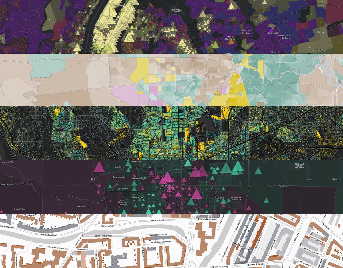
This collection of maps provides examples of #Arcade expressions within the #SmartMapping interface. Find ideas for creating your own stunning #maps here: p.ctx.ly/r/99vf

Explore two attributes in a relationship visualization (bivariate choropleth) using the #SmartMapping relationship module. Learn more: p.ctx.ly/r/8jwt #DataViz #JavaScript

RT @Esri - Learn how to easily make a map that compares two different topics with the new Relationship #mapping style in @ArcGISOnline! Esri's @lisaberry_gis shows you how buff.ly/2m7bWBp #SmartMapping #ArcGIS #EsriUC buff.ly/2m7bX8r

Learn how to easily make a map that compares two different topics with the new Relationship #mapping style in @ArcGISOnline! Esri's @lisaberry_gis shows you how p.ctx.ly/r/7y18 #SmartMapping #ArcGIS #EsriUC
Who knew you could create 14 different #maps with just 2 variables? @jbellmaps shows us how it's done. Learn more about #smartmapping here: p.ctx.ly/r/7zbx #EsriUC


New sliders coming to #esrijs are insane! Can power #smartmapping filtering, histograms, #a11y and more! #esri #devsummit #smapping


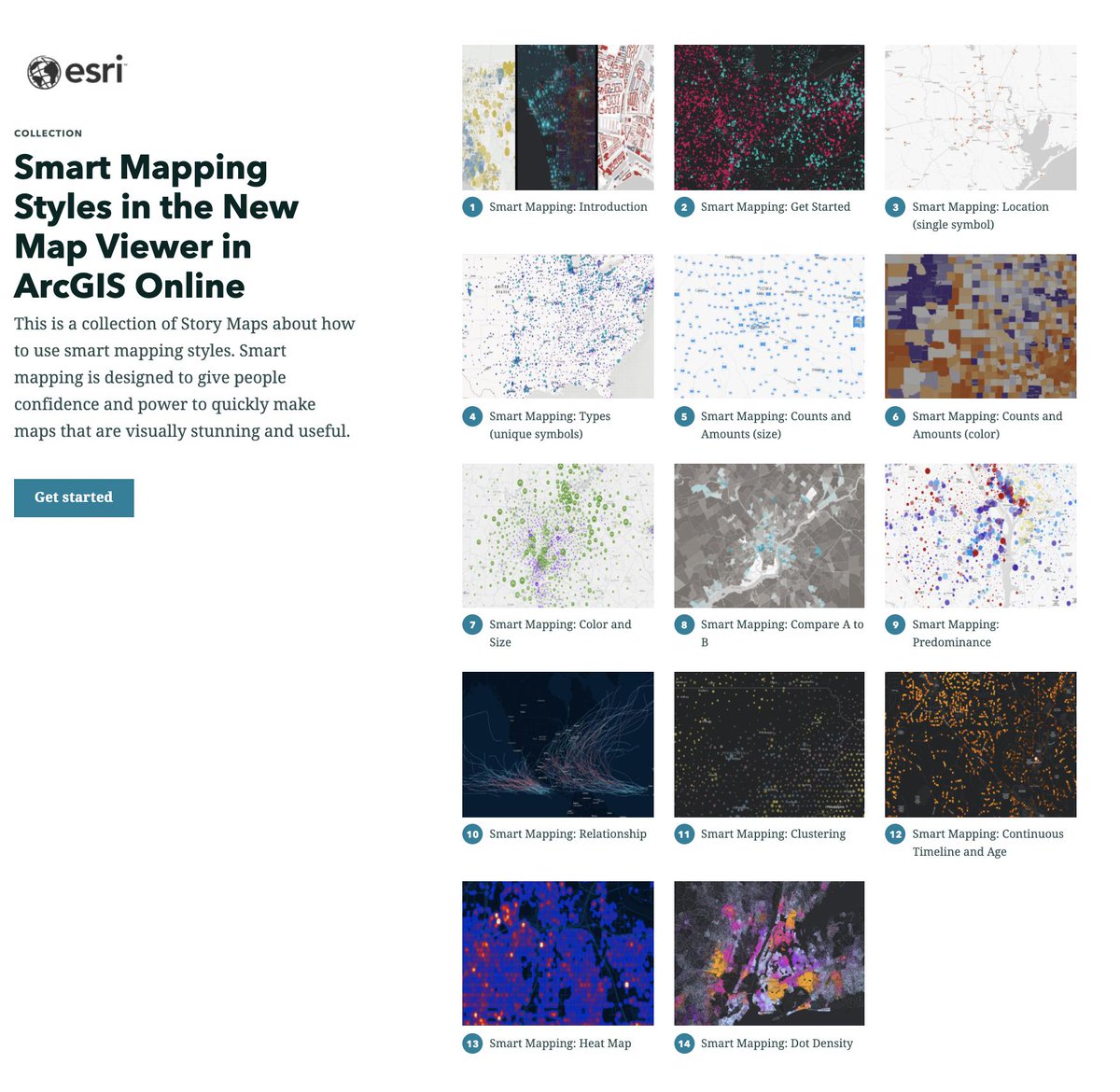
Learn how to make beautiful and informative maps in @ArcGISOnline Map Viewer with this new set of tutorials about #smartmapping: storymaps.arcgis.com/collections/9d… @ArcGISStoryMaps

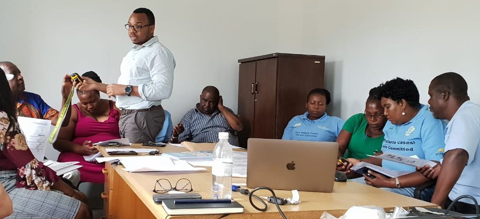
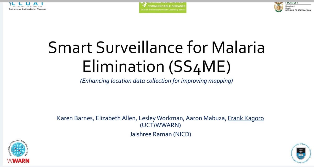
Sharing experience and knowledge with malaria case investigators on methods to obtain the correct locations of cases! #SmartMapping! #SmartSurveillance4MalariaEliminationProject @WWARN

Get smart with Smart Mapping! Esri cartographic engineers @jbellmaps and @dianaclavery demonstrate the #smartmapping capabilities in @ArcGISOnline p.ctx.ly/r/8rm4 #Maps #ArcGIS


When vegetation, flood zones, and infrastructure overlap, geometry-driven workflows make the difference. This guide lays out how automation built on spatial logic keeps projects moving. 👉tinyurl.com/55dh475j #AEC #GISWorkflows #SmartMapping


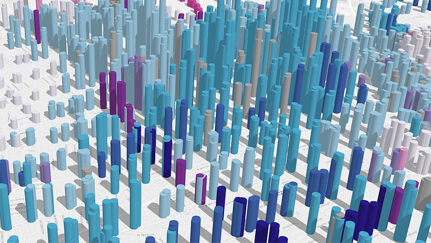
Uncover hidden patterns in your data with Clustering in 3 easy steps esriurl.com/clustering #smartmapping #makebettermaps #ArcGISOnline

This is powerful- explore your data at the speed of discovery. Get caught up with all the smart mapping styles available in the new Map Viewer. #esri #ArcGISOnline #smartmapping #esriuc

Soon, #ArcGISOnline #smartmapping tools will help you see and understand how your color ramps and your data are interacting. Mean, 1 standard deviation above and below indicators. This helps you understand how you are emphasizing what's important and de-emphasizing what's not.


#3dmodeling #smartmapping #Covid_19india @ngpnmc #innovativedevelopment @Tukaram_IndIAS #Jointvevture @CSIR_IND @CSIR_NEERI @CSIRIIP #googleearth #moreawarenessmoresafety #firstdistrictmodel,17th 2020 @shekhar_mande @kumarneeri @PMOIndia @CMOMaharashtra (Marathi Description)

Rene Rubalcava (@odoenet) introduces features of the #JavaScript #API 4.0 such as #SmartMapping and #visualization through #heatmaps. #devsummit

Readers don't want to scroll through a long list of attributes in a map pop-up. They want your popup to have a few sentences that tell readers the key info up top. Then, if you must, you can list ALL the attributes. If you have good field aliases. #ArcGISOnline #smartmapping

I know I love creating maps that combine color and size within @ArcGISOnline, and sometimes my maps need some reinforcement. Check out this blog about how to add a layer of clarity (literally) to your color and size maps: esri.com/arcgis-blog/pr… #smartmapping


No more typing full addresses — just start, and let Google do the rest. Smart, fast, and effortless address mapping in seconds. 💡 Autofill that actually saves time! wpmapspro.com/map-hooks/wpgm… #WPMAPS #GoogleAutocomplete #SmartMapping

When vegetation, flood zones, and infrastructure overlap, geometry-driven workflows make the difference. This guide lays out how automation built on spatial logic keeps projects moving. 👉tinyurl.com/55dh475j #AEC #GISWorkflows #SmartMapping

Census 2027 mock drill to begin in October: Exercise to run for 60 days; entire country to be mapped using smart technology english.bhaskar.com/TwVU2ix3DWb #Census2027 #MockDrill #SmartMapping #DigitalIndia #DataCollectionInitiative
english.bhaskar.com
Census 2027 mock drill to begin in...
Exercise to run for 60 days; entire country...

Autonomous. Intelligent. Future-ready. The Leica Pegasus TRK EVO transforms reality capture with AI, automated workflows & built-in privacy. 🔗 sitml.com/product/leica-… #LeicaGeosystems #RealityCapture #SmartMapping #AI


Seamless Data Integration starts with Smart Mapping! From Data Mapping to Automation Tools, ensure accuracy & efficiency. Explore: statswork.com/dictionary-map… #DataIntegration #SmartMapping #DataScience #BigData #Automation


GIS mapping supports agriculture, infrastructure, and environmental monitoring with high-precision geographic data. #SmartMapping #TechForLand Anguilla’s .ai domain attracts global companies and provides a valuable revenue stream for the government’s IT sector.

Map your city. Collect revenue smarter. 📍💰 RevMap delivers accurate property mapping, live revenue dashboards, and transparent staff tracking. 📞 Call 0245177399 | ✉️ [email protected] #RevMap #RevenueGrowth #SmartMapping #PropertyMapping #MobiSolutions #G


📍India’s New Era of Location Intelligence! DIGIPIN is Live Find your DIGIPIN Now: digipin.net.in/en/find-digipin At Heliware, we’re excited about what this means for the future of #locationintelligence and #smartmapping across Bharat #DIGIPIN #DigitalIndia #GeospatialMapping


This collection of maps provides examples of #Arcade expressions within the #SmartMapping interface. Find ideas for creating your own stunning #maps here: p.ctx.ly/r/99vf
Explore two attributes in a relationship visualization (bivariate choropleth) using the #SmartMapping relationship module. Learn more: p.ctx.ly/r/8jwt #DataViz #JavaScript
Who knew you could create 14 different #maps with just 2 variables? @jbellmaps shows us how it's done. Learn more about #smartmapping here: p.ctx.ly/r/7zbx #EsriUC
Abram explaining what we do to power the #smartmapping using #NLP techniques and a neural net that is trained with user data #SaaSConnectivity #TIBCOCloudIntegration #TIBCONOW
RT @Esri - Learn how to easily make a map that compares two different topics with the new Relationship #mapping style in @ArcGISOnline! Esri's @lisaberry_gis shows you how buff.ly/2m7bWBp #SmartMapping #ArcGIS #EsriUC buff.ly/2m7bX8r
Get smart with Smart Mapping! Esri cartographic engineers @jbellmaps and @dianaclavery demonstrate the #smartmapping capabilities in @ArcGISOnline p.ctx.ly/r/8rm4 #Maps #ArcGIS
Learn how to make beautiful and informative maps in @ArcGISOnline Map Viewer with this new set of tutorials about #smartmapping: storymaps.arcgis.com/collections/9d… @ArcGISStoryMaps
Uncover hidden patterns in your data with Clustering in 3 easy steps esriurl.com/clustering #smartmapping #makebettermaps #ArcGISOnline

#SmartMapping en #ArcGIS ahorra tiempo y esfuerzo en el diseño de tus webmaps #CEsri18 Con @JaimeNieves y @crismo__

Should you draw several hundred thousand dots on a map? Well, you could, but the cluster style with labels you can control easily makes for #smartmapping in Map Viewer Beta #EsriUC #EsriUC2020 #ArcGISOnline

I know I love creating maps that combine color and size within @ArcGISOnline, and sometimes my maps need some reinforcement. Check out this blog about how to add a layer of clarity (literally) to your color and size maps: esri.com/arcgis-blog/pr… #smartmapping
Rene Rubalcava (@odoenet) introduces features of the #JavaScript #API 4.0 such as #SmartMapping and #visualization through #heatmaps. #devsummit
This is powerful- explore your data at the speed of discovery. Get caught up with all the smart mapping styles available in the new Map Viewer. #esri #ArcGISOnline #smartmapping #esriuc
Map Viewer Beta just reached full #SmartMapping parity! Here are 5 more reasons to try it out bit.ly/3cElV9Z #ArcGISOnline #esri #dataviz

April 8, 11:30 am Pacific Join @lisaberry_gis and I at #Esri #DevSummit for demos and Live Q&A #smartmapping #geodev #gis ow.ly/rbWE50DGRso

New sliders coming to #esrijs are insane! Can power #smartmapping filtering, histograms, #a11y and more! #esri #devsummit #smapping

A pleasure and privilege to share ideas + resources with PGCE Geographers @igeogstmarys @YourStMarys #GIS Many thanks for working so hard at the end of a tiring term! #resilience #smartmapping #flowlines #RSSfeeds @esriSurvey123 #Scene #StoryMaps etc @GIS4Schools @geogologue

Esri just released Map Viewer Beta! Go behind the scenes of the new color ramps designed with color theory in mind🎨bit.ly/2r8b9pJ #SmartMapping #MapViewerBeta #ArcGISOnline

Express yourself (and your data!) with Arcade expressions in 5 easy steps shar.es/anoDpt #esri #smartmapping #arcadeexpressions
Something went wrong.
Something went wrong.
United States Trends
- 1. South Carolina 18.2K posts
- 2. Texas A&M 17.7K posts
- 3. Marcel Reed 3,233 posts
- 4. Shane Beamer 1,113 posts
- 5. Aggies 5,250 posts
- 6. Semaj Morgan N/A
- 7. College Station 2,422 posts
- 8. Nyck Harbor 2,128 posts
- 9. Elko 2,791 posts
- 10. Northwestern 4,918 posts
- 11. Sellers 9,948 posts
- 12. Jeremiyah Love 3,820 posts
- 13. Michigan 39.9K posts
- 14. Malachi Fields 1,869 posts
- 15. TAMU 6,194 posts
- 16. Mike Shula N/A
- 17. #iufb 1,778 posts
- 18. #GoBlue 2,455 posts
- 19. #GoIrish 3,501 posts
- 20. Sherrone N/A