#spatialanalytics Suchergebnisse

At JapakGIS, we assist Public health agencies use Web Maps dashboards to track epidemic spread, visualize hotspots, and allocate medical resources effectively. #JapakGIS #SpatialData #SpatialAnalytics #GISForDevelopment #GeospatialSolutions


📍 Pin maps ≠ spatial strategy. Gen BI uses geospatial intelligence for KPIs, coverage, and action. Explore mapping in Tableau 2025 → [landing.packtpub.com/learning-table…] #GenBI #Tableau2025 #SpatialAnalytics #BIPro
![PacktDataML's tweet image. 📍 Pin maps ≠ spatial strategy.
Gen BI uses geospatial intelligence for KPIs, coverage, and action.
Explore mapping in Tableau 2025 → [landing.packtpub.com/learning-table…] #GenBI #Tableau2025 #SpatialAnalytics #BIPro](https://pbs.twimg.com/media/Gx0G1ZYbsAMTNZk.jpg)

Our SVP of Product, Andy Bell, joined Mike Loder on Ticker to talk about the power of trusted data—how enrichment & spatial analytics boost AI, insights & smarter decisions. Watch the full interview: okt.to/uGqJrN #DataIntegrity #AI #SpatialAnalytics


Our SVP of Product, Andy Bell, joined Mike Loder on Ticker to talk about the power of trusted data—how enrichment & spatial analytics boost AI, insights & smarter decisions. Watch the full interview: okt.to/X6A3Jn #DataIntegrity #AI #SpatialAnalytics


Our SVP of Product, Andy Bell, joined Mike Loder on Ticker to talk about the power of trusted data—how enrichment & spatial analytics boost AI, insights & smarter decisions. Watch the full interview: okt.to/U6l5Ee #DataIntegrity #AI #SpatialAnalytics


Our SVP of Product, Andy Bell, joined Mike Loder on Ticker to talk about the power of trusted data—how enrichment & spatial analytics boost AI, insights & smarter decisions. Watch the full interview: okt.to/VvUasT #DataIntegrity #AI #SpatialAnalytics


🌍Mapping Moments, Connecting Worlds At #EsriUC2025, it’s not just about maps, it’s about integrating everything, everywhere. Day1 inspired us with keynotes from Jack Dangermond & Dr. Kirk Johnson. Our team is here! Let’s connect! @Esri @EsriUC #MannaiGIS #SpatialAnalytics


Interested in Generative AI for GIS? come talk to me #GeoAgents #MCP #SpatialAnalytics #EsriUC2025 #GeoLLM

🌍 ArcGIS for Microsoft 365's June 2025 update is here! Get ready for smoother spatial data workflows that fit right into your favorite productivity tools. Who knew analytics could be this fun? #ArcGIS #Microsoft365 #SpatialAnalytics ift.tt/y4C2YmU

Slow maps? Missed insights? We’re scaling geospatial analysis with PostGIS, DuckDB, GeoArrow & deck.gl. See how we turn massive datasets into fast, interactive maps in the video below. 📽️ Watch now: bit.ly/HPGDTLL #DataViz #Geospatial #SpatialAnalytics


AI-powered GIS is transforming spatial data analysis from predictive modeling to automated feature extraction. It’s enabling smarter & faster decisions. Are you using AI to elevate your spatial insights? 👉 12thwonder.com/Geospatial-Sol… #AI #GIS #SpatialAnalytics

At JapakGIS, we develop custom project geo-apps to enhance user experiences by integrating location-based services for project maps visualization. #JapakGIS #DigitalMapping #SpatialAnalytics #DataVisualization #GeoAnalytics #SmartCities #UrbanPlanning #InfrastructureMapping


Our Spatial Data Science free MOOC starts tomorrow! Gain hands-on experience performing suitability analysis, predictive modeling, and more. 🔹Register: esri.social/nVfr50PCA0P #SpatialAnalytics

Tourism infographic map with hotel, restaurant, and attraction icons. 🌍 JapakGIS specializes in creating custom maps that enhance travel experience. 📊 #JapakGIS #LocationIntelligence #SpatialAnalytics #DataVisualization #GeoAnalytics #SmartCities #UrbanPlanning


Did You Know 💡 R-ArcGIS combines the power of open-source R packages with mapping, visualization and #spatialanalytics of #ArcGIS 🙌 . Learn how this powerful tool can enhance your research and teaching: esri.social/xlQi50TLenf

At JapakGIS, we assist Public health agencies use Web Maps dashboards to track epidemic spread, visualize hotspots, and allocate medical resources effectively. #JapakGIS #SpatialData #SpatialAnalytics #GISForDevelopment #GeospatialSolutions


Get an inside look at what spatial thinking brings to some of the world’s biggest brands like @amazon, @FedEx, and @Marriott. 🔹Register for our WhereNext Webcast: esri.social/oQRA50PYKMx #SpatialAnalytics #Business

🌍Mapping Moments, Connecting Worlds At #EsriUC2025, it’s not just about maps, it’s about integrating everything, everywhere. Day1 inspired us with keynotes from Jack Dangermond & Dr. Kirk Johnson. Our team is here! Let’s connect! @Esri @EsriUC #MannaiGIS #SpatialAnalytics

Spatial analytics and data science were hot topics at this year's #EsriUC2023! For an overview of the important topics discussed at UC, check out this blog for a recap of the top #spatialanalytics trends. ow.ly/XNuV104SHPe


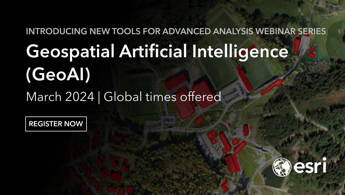
Join Esri upcoming webinar series and unleash the power of #GeoAI! Learn how advanced techniques can help you detect clusters, calculate change, find patterns, and forecast future events. #GIS #SpatialAnalytics Register here: shorturl.at/qNQU7

Join the Spatial and Data Science Society of Nigeria and be part of the revolution in GeoAI, Data Science, and Spatial Analytics! 🌍 Mapping the future, one data point at a time. Become a member today: (sdssn.org) #GeoAI #DataScience #SpatialAnalytics #SDSSN


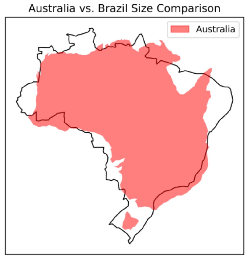
A great piece by Lee Vaughan titled 𝐂𝐨𝐦𝐩𝐚𝐫𝐢𝐧𝐠 𝐂𝐨𝐮𝐧𝐭𝐫𝐲 𝐒𝐢𝐳𝐞𝐬 𝐰𝐢𝐭𝐡 𝐆𝐞𝐨𝐏𝐚𝐧𝐝𝐚𝐬 on @TDataScience . Read it here: towardsdatascience.com/comparing-coun… #GIS #spatialanalytics #geospatialdata #geospatial #datascience #datavisualization


Unlock the power of your graph databases with #ArcGISKnowledge! The latest update allows seamless integration with #Neo4j, enabling you to connect and analyze your existing graph databases without data duplication. #spatialanalytics Learn more ➡️ ow.ly/fAWr50QKxSO


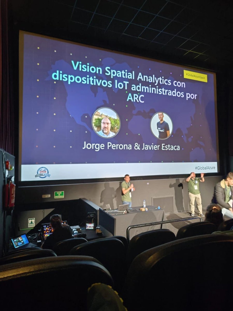
.@JrgPerona y Javier Estaca también fueron ponentes en el #globalazure Madrid. 💻 En su sesión, mostraron cómo desplegar #SpatialAnalytics en un dispositivo #IoT con #AzureDevOps. ¡Una charla muy interesante! 🚀 @GlobalAzureES


Must-Attend December Talks🎙️ Join us this December for two insightful sessions that will elevate your data expertise, packed with insights, innovation, and practical takeaways. RSVP now: hubs.la/Q02Zfx6s0 #DataScience #NetworkScience #SpatialAnalytics #MicrosoftFabric


Unlock the Power of #SpatialAnalytics ! From smarter urban planning to optimised supply chains, spatial data is reshaping industries. This article by @ciarankirk, IMGS & DataBuilders, explores the tools & insights driving this revolution: zurl.co/eMDwO #GIS

In 𝐌𝐢𝐥𝐚𝐧'𝐬 𝐃𝐚𝐭𝐚 𝐒𝐭𝐨𝐫𝐢𝐞𝐬 #005 - 𝐑𝐚𝐬𝐭𝐞𝐫 𝐏𝐨𝐩𝐮𝐥𝐚𝐭𝐢𝐨𝐧 𝐌𝐚𝐩𝐬, we dive into raster population maps in Python one-liners. Check the tutorial on YouTube: youtu.be/OGejs3vPMes #GIS #spatialanalytics #geospatialdata #datascience #datavisualization


🌐🏠 How to use crime data & spatial analysis for to scale your insurance risk assessments! Learn how you can scale your spatial analysis to generate hyper-local, building-level insights to drive decision making 👇 #SpatialAnalytics #Insurtech hubs.ly/Q02zHrzz0

Are you following the UEFA European Championship? Well, here comes its data aspect - 𝐔𝐄𝐅𝐀 𝐄𝐮𝐫𝐨 2024 𝐌𝐚𝐩 on @TDataScience : medium.com/towards-data-s… #GIS #spatialanalytics #geospatialdata #geospatial #datascience #datavisualization

Something went wrong.
Something went wrong.
United States Trends
- 1. Dodgers 16.7K posts
- 2. Mets 17.7K posts
- 3. Stearns 4,621 posts
- 4. Kyle Schwarber 7,675 posts
- 5. Phillies 8,592 posts
- 6. Cohen 9,165 posts
- 7. Devin Williams N/A
- 8. Alonso 69.7K posts
- 9. Reds 14.7K posts
- 10. Tanner Scott N/A
- 11. 271% YoY N/A
- 12. #NXXT_RecordRun N/A
- 13. #tuesdayvibe 3,069 posts
- 14. Pirates 21K posts
- 15. 5M YTD N/A
- 16. Lockout 1,145 posts
- 17. The BONK 105K posts
- 18. Raul Malo N/A
- 19. FINALLY DID IT 564K posts
- 20. Ghislaine Maxwell 7,941 posts