#spilhaus search results

Très heureux de savoir que ma #carte de #Spilhaus va être exposée dans le cadre d'une exposition du Science Museum de Londres ! :)


Ça fait toujours plaisir de voir sa carte affichée chez un particulier ! #Spilhaus #LeCartographe le-cartographe.net/publications/4…

Ma carte des océans conçue par Athelstan F. #Spilhaus continue à voyager après le Science Museum de Londres, la voici à la Zentralbibliothek de Zurich pour une exposition sur, entre autres, les projections géographiques. 👌


هذه المرة، استخدمت مسقط #spilhaus والذي انتشر مؤخرا بفضل أعمال الكارتوجرافي المتميز @John_M_Nelson هذا المسقط يعرض المحيطات بشكل متصل، مما يفيد المتخصصين في علوم البحار والمحيطات عند عرض بياناتهم مثل التيارات البحرية وحركة السفن


Thanks to rapid advances in mapping technology, and a growing recognition of the seabed’s importance, a comprehensive map of the ocean floor is within reach. ow.ly/FYUe50JHvJa #spilhaus @seabed2030

@nico_lambert Un grand merci pour l’envoi. C’est un beau travail : à la fois ludique et indispensable ! Pour voir le monde sous un autre angle c’est #MadMaps ! Avec en bonne place ma carte de #Spilhaus 👍


#OceansPerspective World Map from 1942, created by Athelstan #Spilhaus Rather unique perspective: the world's oceans as one body of water 🌊 🌏💧 🗺 bigthink.com/surprising-sci…


It's World Oceans Day. An opportunity to bring out this amazing map made with @lecartographe for #MadMapAtlas. #WorldOceansDay #Spilhaus


#30DayMapChallenge Day18: Blue World Bathymetry in #Spilhaus Projection Data: @gebcobathymetry & @NASA #BlueMarble Used @Esri #ArcGISPro & @blender #Kuwait #kuwait_university #cartography #b3d #الكويت #جامعة_الكويت #جغرافيا #خرائط


Ma carte de #Spilhaus (Les océans au centre du monde) dans une exposition sur les projections géographiques à #Zurich 🥰


🗺🌊 En la próxima versión de #ArcGIS Pro se mostrarán los #mapas de los océanos sin fin de la proyección de #Spilhaus. 🌐 Enlace: esri.com/arcgis-blog/pr… Fuente: @esrigis


Read about #Spilhaus world ocean map in the Technology Showcase chapter by #Esri staff in the GIS for Science, vol 2 book by @deepseadawn and @GeoHarder dusk.geo.orst.edu/Pickup/Esri/Sc… Obviously, @John_M_Nelson had something to do with these cool looking maps and graphics. Ignore them.😉


¿Conoces la proyección Spilhaus? Es la representación del planisferio terrestre desde el punto de vista de un pez! 🐟🌍 southernwoodenboatsailing.com/news/the-spilh… #ciencia #spilhaus

✨Il giro del mondo insieme alle correnti oceaniche 🔈Scopri come si muovono gli #oceani: osserva la mappa delle correnti oceaniche di #Spilhaus realizzata con #ArcGISOnline🌐 #Esri #GIS #mapping #geospatial #technology #ocean #TheSpilhausWorldOceanMap #OceanSurfaceCurrents

#30DayMapChallenge J28 🌊 #BluePlanet Les océans recouvrent plus de 70 % de la surface de la Terre, ce qui lui vaut le surnom de "Planète bleue". C’est par le processus d’absorption sélective que la mer est bleue : le spectre lumineux se décompose lorsque la lumière frappe la…


#30daymapchallenge Jour 5 #voyage Le tour du monde réalisé par mes grands parents sur le bateau que mon grand père a construit dans son jardin, l'Hermine. #spilhaus Carte faite avec @inkscapeofficial et beaucoup d'amour instagram.com/p/DCAXQvXtnbq/…
instagram.com
Hugo Le Naviel (@hlnmaps) • Instagram photo
Hugo Le Naviel (@hlnmaps) • Instagram photo

The Spilhaus Projection: World map according to fish... (This projection, designed by Dr. Athelstan Spilhaus, a renowned meteorologist and oceanographer, offers a refreshingly different perspective on our planet) #WorldMap #FishEyeView #Spilhaus #Projection #Oceans #Cartography


#スピルハウス (#Spilhaus) の海洋世界図は世界の大洋を地中海のように表現した図。#アダムス第二図法 のパラメーターを調整して描いてます。 #ArcGISPro で #WKID : 54099 を指定すれば簡単につくれます。 #地理院地図 (左) と衛星画像 (右)。 storymaps.arcgis.com/stories/756bca… #地図投影法


How do the surface ocean currents look like in Spilhaus projection? Check it out! #Oneocean #Copernicus #Spilhaus

🌊 Cos'è questa mappa? La proiezione di Spilhaus ci offre un mondo dove gli oceani sono al centro di tutto, come ci ricorda anche @giovannisoldini. È una mappa che ci fa riflettere: abbiamo raccontato tutto nell'articolo su aroundtheblue.org #oceano #spilhaus #mappa #mappe


If you wanna see the progress of the #ogr2023 participants on a #spilhaus ocean map, clone my Github repo from github.com/rahra/decyb and open the file "html/decyb.html" and add the URL parameter "?race=ogr2023". #javascript


Una nueva visión del planeta #Océano! A diferencia de otras proyecciones cartográficas, la de #Spilhaus se centra en nuestros océanos y permite ver mejor algunas de sus características globales. @kr_wittmann @letras_ciencia @ANAISABELGONZL2 @NaoCasanova nature.com/articles/s4159…
nature.com
Ocean Sciences with the Spilhaus Projection: A Seamless Ocean Map for Spatial Data Recognition
Scientific Data - Ocean Sciences with the Spilhaus Projection: A Seamless Ocean Map for Spatial Data Recognition

Along with a short video for introducing the Spilhaus paper: youtu.be/Xv-rxroPnJQ #Spilhaus #oceanscience #mapping #geoinformatics

youtube.com
YouTube
Ocean Sciences with the Spilhaus Projection: A Seamless Ocean Map for...
Check out our recent paper: "Ocean Sciences with the Spilhaus Projection: A Seamless Ocean Map for Spatial Data Recognition". nature.com/articles/s4159…… #Spilhaus #oceanscience #mapping #geoinformatics

Another highly sketchy entry for #mappromptmonday, Proportional Symbols based on population and I wanted an excuse to use the #spilhaus projection in #qgis. That said, I had to reproject everything in #arcgispro first but as long as the projection matches, you're good to go.


The cartomooc people are publishing their #spilhaus maps and every time I see that name I think of frat parties.

Like so many, i fell for #Spilhaus projection from #cartoMooc too The map: #coralreefs are an important #ecoystem habitat in the ocean. They also play an important role in tackling #climate change. This map shows the #global warm water coral distribution @EsriTraining #Arcgispro


Having some fun solar dying some bags for the speakers of our Future DEEP Workshop. Future Drilling to Explore Earth’s Past #Spilhaus #IODP @anzic_iodp


🔺️In-person registration closes Monday, March 20! 🔺️Virtual registration will stay open until April 2 (note that only day one is hybrid)🙌 🔺️Detailed schedule will be announced early next week 🤓

Ça fait toujours plaisir de voir sa carte affichée chez un particulier ! #Spilhaus #LeCartographe le-cartographe.net/publications/4…


Cc @helenafricker 🥰☃️ #spilhaus
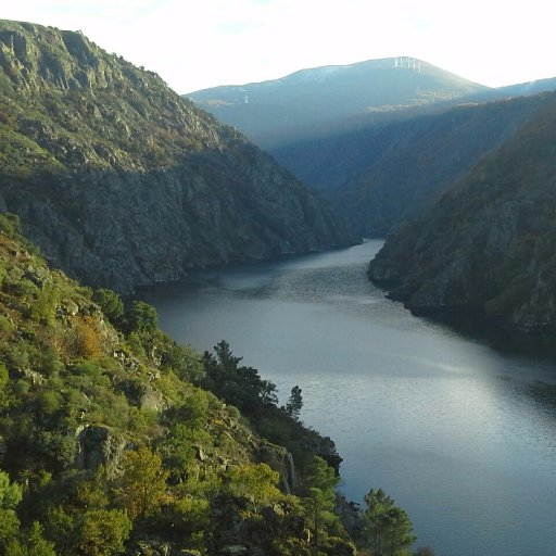
This is how the global ocean should be seen, with #Antarctic & the #SouthernOcean at the ❤️ #OneOcean #Spilhaus #IODP Working on a new perspective for past & future #ScientificOceanDrilling sites to showcase during the #ANZICroadshow See you this week @UNSW & @sydneyunigeo
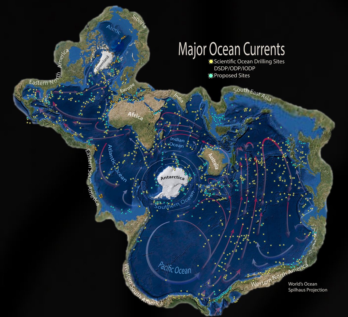


En 1942, Athelstan F. #Spilhaus réalise une carte fascinante. Les régions marines sont représentées au centre du monde #Projection #Map

Très heureux de savoir que ma #carte de #Spilhaus va être exposée dans le cadre d'une exposition du Science Museum de Londres ! :)
Ça fait toujours plaisir de voir sa carte affichée chez un particulier ! #Spilhaus #LeCartographe le-cartographe.net/publications/4…
It's World Oceans Day. An opportunity to bring out this amazing map made with @lecartographe for #MadMapAtlas. #WorldOceansDay #Spilhaus
🗺🌊 En la próxima versión de #ArcGIS Pro se mostrarán los #mapas de los océanos sin fin de la proyección de #Spilhaus. 🌐 Enlace: esri.com/arcgis-blog/pr… Fuente: @esrigis
#30DayMapChallenge Day18: Blue World Bathymetry in #Spilhaus Projection Data: @gebcobathymetry & @NASA #BlueMarble Used @Esri #ArcGISPro & @blender #Kuwait #kuwait_university #cartography #b3d #الكويت #جامعة_الكويت #جغرافيا #خرائط


Ma carte des océans conçue par Athelstan F. #Spilhaus continue à voyager après le Science Museum de Londres, la voici à la Zentralbibliothek de Zurich pour une exposition sur, entre autres, les projections géographiques. 👌
@nico_lambert Un grand merci pour l’envoi. C’est un beau travail : à la fois ludique et indispensable ! Pour voir le monde sous un autre angle c’est #MadMaps ! Avec en bonne place ma carte de #Spilhaus 👍
هذه المرة، استخدمت مسقط #spilhaus والذي انتشر مؤخرا بفضل أعمال الكارتوجرافي المتميز @John_M_Nelson هذا المسقط يعرض المحيطات بشكل متصل، مما يفيد المتخصصين في علوم البحار والمحيطات عند عرض بياناتهم مثل التيارات البحرية وحركة السفن
Thanks to rapid advances in mapping technology, and a growing recognition of the seabed’s importance, a comprehensive map of the ocean floor is within reach. ow.ly/FYUe50JHvJa #spilhaus @seabed2030
#GISforScience volume 2 now available in print! #sciencesymposium #spilhaus


thanks @GeoHarder @deepseadawn for this great new edition #GIS Esri - so many great new examples including #spilhaus #ocean #projection lnkd.in/gMyrK2Z
Read about #Spilhaus world ocean map in the Technology Showcase chapter by #Esri staff in the GIS for Science, vol 2 book by @deepseadawn and @GeoHarder dusk.geo.orst.edu/Pickup/Esri/Sc… Obviously, @John_M_Nelson had something to do with these cool looking maps and graphics. Ignore them.😉

Playing with the #Spilhaus projection that is now available in @ArcGISPro 2.5, thanks to @BojanSavric et al.

Something went wrong.
Something went wrong.
United States Trends
- 1. Good Thursday 23.8K posts
- 2. #GrabFoodMegaSalexหลิงออม 110K posts
- 3. SUSDT N/A
- 4. PancakeSwap BNB Chain N/A
- 5. Happy Friday Eve N/A
- 6. Rejoice in the Lord 1,803 posts
- 7. #River 5,659 posts
- 8. #WorldKindnessDay 7,511 posts
- 9. #thursdayvibes 2,154 posts
- 10. #thursdaymotivation 1,572 posts
- 11. Namjoon 89.9K posts
- 12. New Zealand 14.6K posts
- 13. Jokic 29.8K posts
- 14. Mikey 57.5K posts
- 15. Horizon 28.1K posts
- 16. Clippers 15.8K posts
- 17. Rory 8,741 posts
- 18. Shai 16.4K posts
- 19. Raising Arizona 1,073 posts
- 20. Thunder 37.8K posts