#gistraining kết quả tìm kiếm

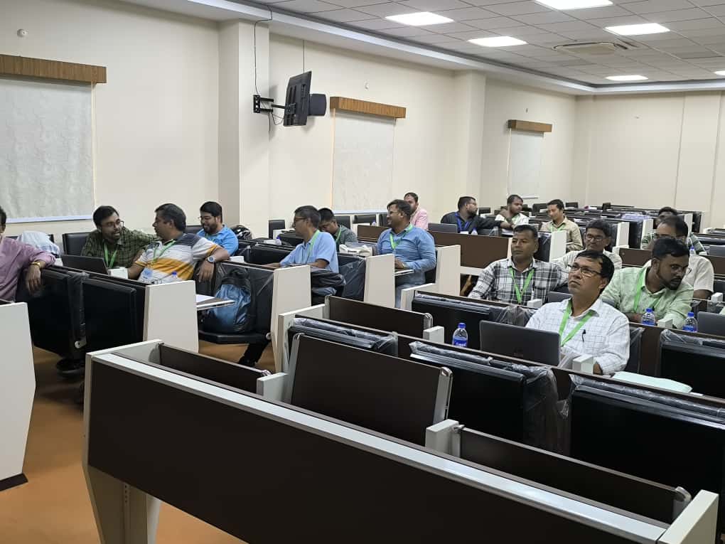
#AIILSG successfully conducted a 3-day #GISTraining Program under #AMRUT in #Kolkata The training was held at ILGUS Bhavan and brought together engineers and ULB officials to build capacity in geospatial planning for better #urbangovernance #capacitybuilding #sustainablecities


Vegetation analysis using soil moisture data is a powerful approach in remote sensing and environmental monitoring. Soil moisture plays a critical role in plant growth, affecting vegetation health, distribution, and productivity. #GoogleEarthEngine #RemoteSensing #GIStraining

Want to grow your GIS skills before the year wraps up? 🎯 We’ve just added new course dates, from beginner to advanced, there’s something for everyone. Spots fill fast! Register now 👉 hubs.ly/Q03QStcf0 #GIStraining #GIS #training


Today, Namami Gange organized a training programme on the topic "Continuously Operating Reference Centre Stations Servics & Application and Usage of Geoid Model" under the GIS Cell & General Knowledge Centre. #GISTraining #GeoidModel #KnowledgeSharing


Air Quality Monitoring with Remote Sensing: Nitrogen Dioxide (NO₂) The Registration details: studyhacksgeospatial.com/google-earth-e… #GoogleEarthEngine #RemoteSensing #GIStraining #EarthObservation #SatelliteData #OnlineTraining #GEEtraining #GeospatialAnalysis #NDVI #LandCoverMapping

At An Garda Síochána, a private #ArcGISPro course has empowered staff to deliver new digital mapping services, reducing paper map requests by nearly 50%! Discover the impact of #LearningServices in our latest case study. @gardainfo #GISTraining @EsriUK ow.ly/rLhU50X6jP8


Unlock practical GIS & Remote Sensing skills in just 7 days. Hands-on, certified and guided by Geoidex experts. 👉 Register today and level up your geospatial career! @GeoidexLTD #gistraining @RCMRD_ @MineNewsAfrica

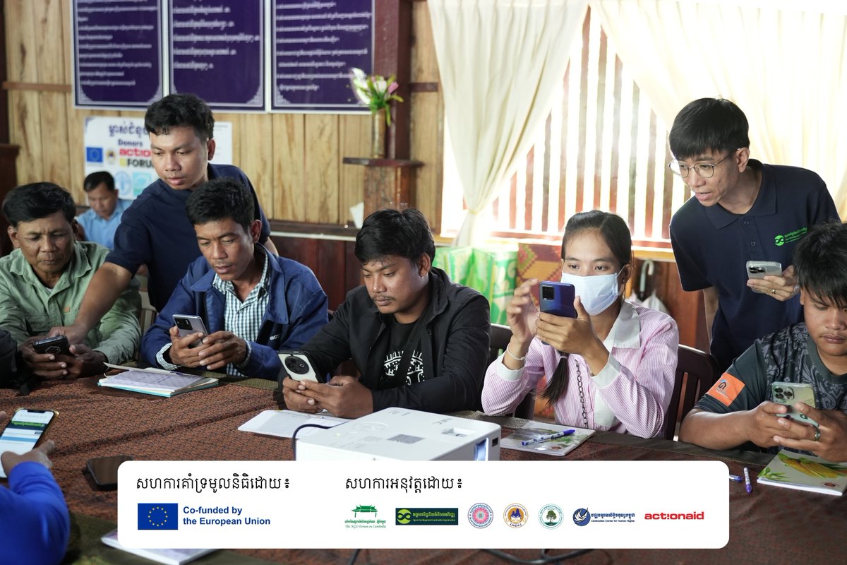
Open Development Cambodia (ODC) successfully conducted the Training Workshop on Community-Based Mapping on 1-2 July 2025, Kampot 🎉✨ #SCAEG #GISTraining #CSO #Mapping #CoastalArea #Avenza #ODC


In our two-day instructor-led course on ArcGIS Survey123, you'll learn advanced Survey123 workflows that will accelerate your data collection process and enhance the quality of your results. Enrol now: ow.ly/mXqs50WNxZO #GIS #ArcGISSurvey123 #GISTraining

🛰️Ready to level up your GIS skills? Join our October training sessions. Spots fill fast, so grab yours today: hubs.ly/Q03KvnmQ0 #GIStraining #GIS #GISAustralia

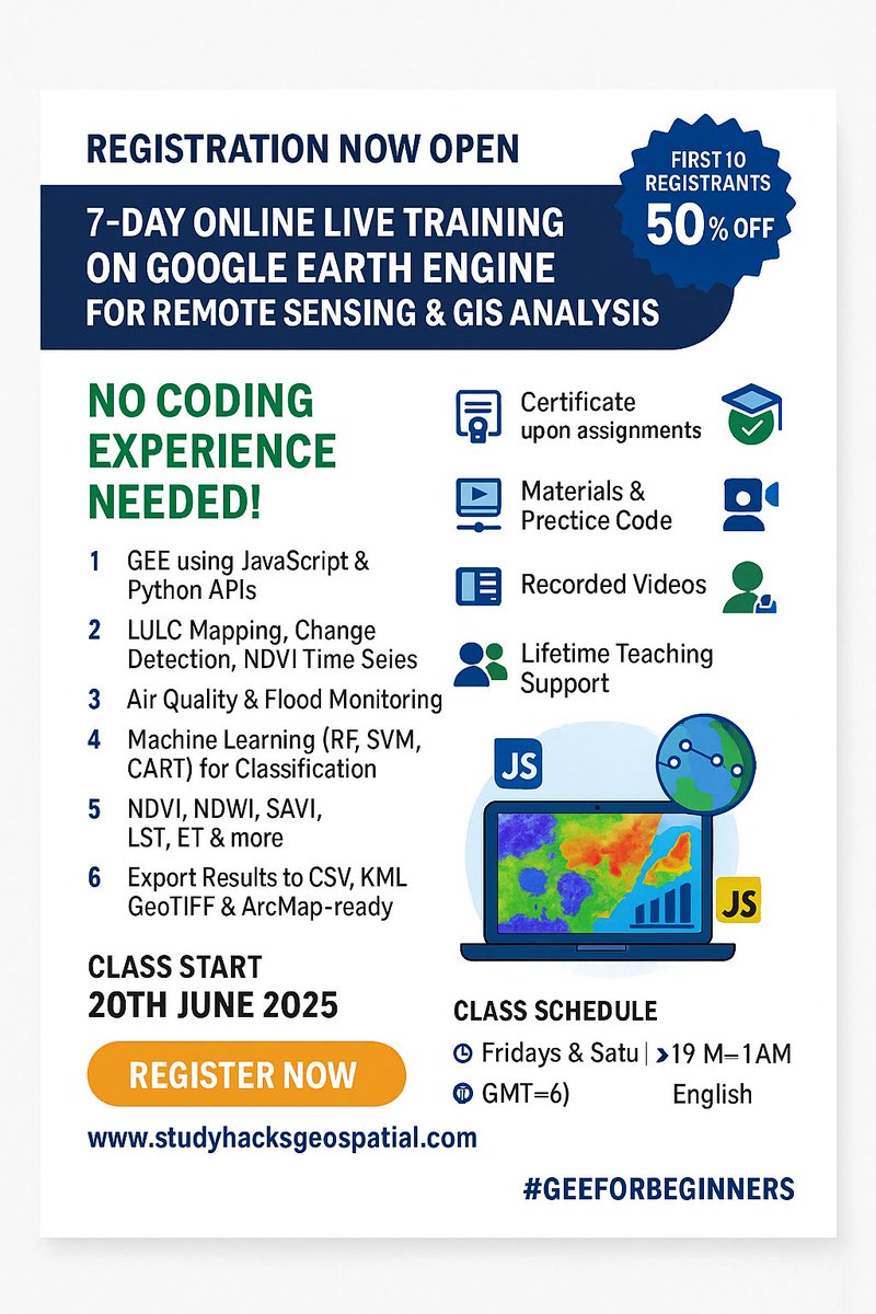
🚨 Registration Now Open! 🚨 7-Day Online Live Training on Google Earth Engine (GEE) for Remote Sensing & GIS Analysis. 📆 Starts: 20th June 2025📍 No Coding Experience Needed! #GoogleEarthEngine #RemoteSensing #GISTraining #EarthObservation #GeospatialAnalysis #MachineLearning
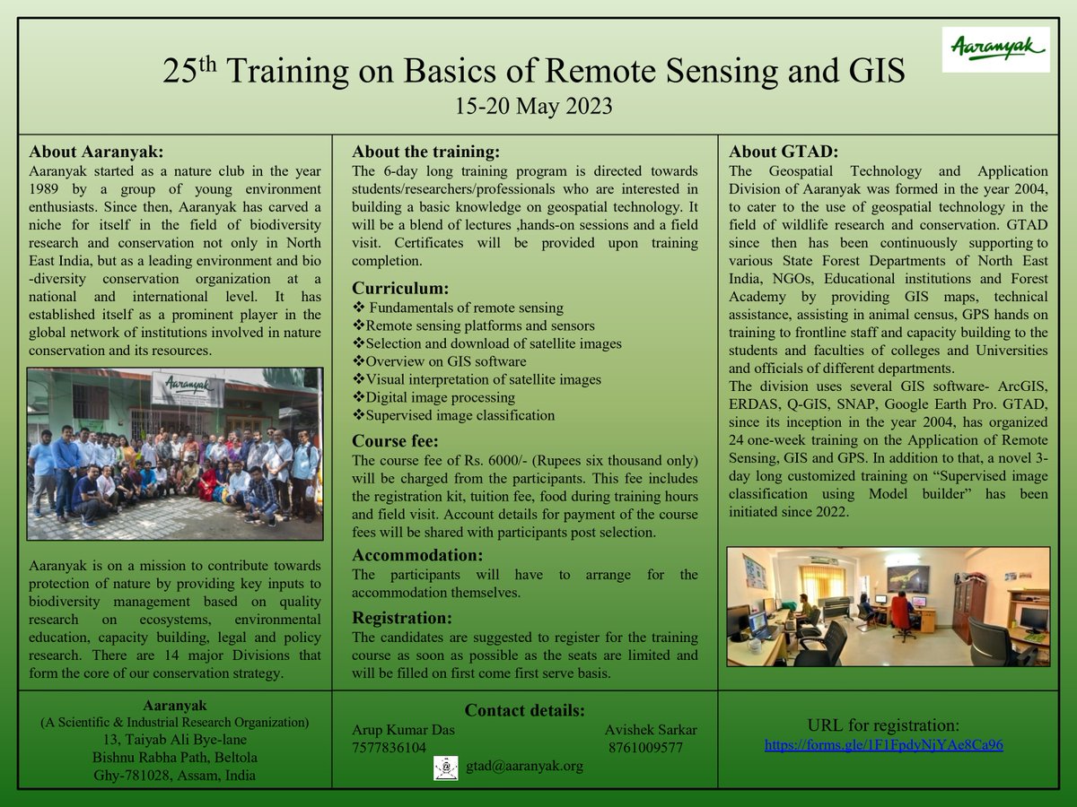
#GISTraining | Last few spots left for the "25th Training on Basics of Remote sensing and GIS", to be organised by #Aaranyak from 15-20 May. #GIS Check out the poster for details-

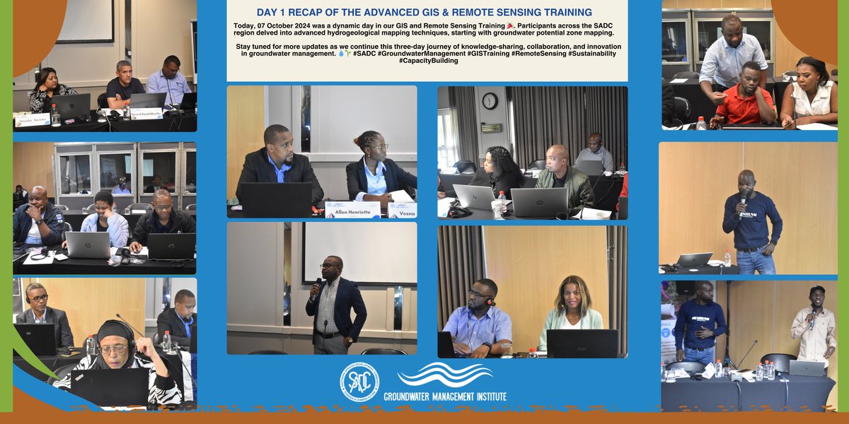
The first day of the Advanced GIS & Remote Sensing Training organized by the SADC -GMI and facilitated by Mzuzu University was a great start. Participants from the SADC region are actively engaged in advanced hydrogeological mapping techniques. #SADC #GISTraining #RemoteSensing

"Geosense Research Lab is offering the second Online course of GIS. We hope that those interested in learning GIS will join this course and benefit from it." #GISCourse #LearnGIS #GISTraining #SpatialAnalysis #GeospatialEducation #GISSkills #GeospatialLearning #MapSkills #Geo

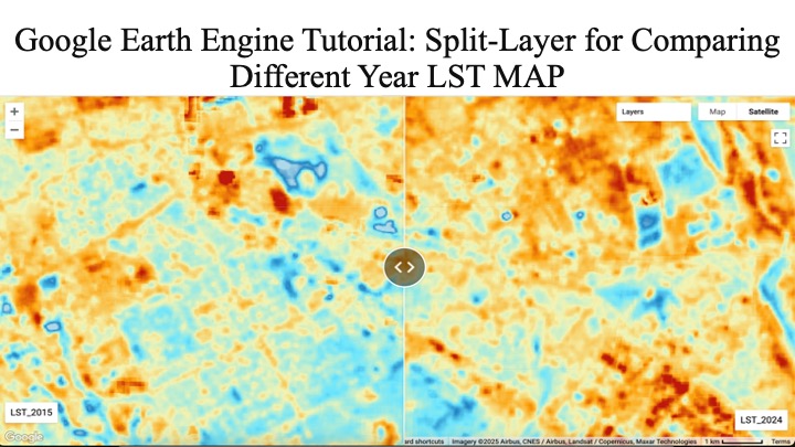
Google Earth Engine Tutorial: Split-Layer for Comparing Different Year LST MAP Tutorial Link: youtu.be/FENCYGQyayw The Registration details: studyhacksgeospatial.com/google-earth-e… #GoogleEarthEngine #RemoteSensing #GIStraining #EarthObservation #SatelliteData #OnlineTraining
📢 Registration is now open for the 32nd Batch of 7-day comprehensive online live training on Google Earth Engine For more information about registration, visit our website: studyhacksgeospatial.com/google-earth-e… #GoogleEarthEngine #RemoteSensingTraining #GISTraining #GeospatialAnalysis


Get #premium #GIS training for less. Our discounted trainings are still ongoing. So whether you are just starting out, looking to advance your skills, or aiming to master GIS, we have the perfect course for you. For more info,call 02092922821 #GISTraining #CareerGrowth


📢 Registration Open for a 7-day complete online live training on Google Earth Engine (GEE) for Remote Sensing and GIS Analysis Registration info: studyhacksgeospatial.com/google-earth-e… #GoogleEarthEngine #RemoteSensingTraining #GIStraining #GeospatialAnalysis #EarthObservation #LULCmapping


If your workforce plans to attend our instructor-led courses this year, we want to make it easier for you.💡💻 Simplify budget planning by purchasing an Esri Training Pass. Learn more at esri.social/MA8G50QM5LM #GIStraining #ArcGIS #GIS


🚀 Whether you’re in urban planning, environmental management, or land administration, our expert-led trainings are designed to bridge the gap between theory and real-world application. #CliffordGeoConsult #GISTraining #CapacityBuilding #ProfessionalWorkshops #GeospatialSkills

Want to grow your GIS skills before the year wraps up? 🎯 We’ve just added new course dates, from beginner to advanced, there’s something for everyone. Spots fill fast! Register now 👉 hubs.ly/Q03QStcf0 #GIStraining #GIS #training
#AIILSG successfully conducted a 3-day #GISTraining Program under #AMRUT in #Kolkata The training was held at ILGUS Bhavan and brought together engineers and ULB officials to build capacity in geospatial planning for better #urbangovernance #capacitybuilding #sustainablecities
Our tailored GIS & Geospatial workshops equip professionals and organizations with the skills to manage spatial data, analyze trends, and make smarter, data-driven decisions. #CliffordGeoConsult #GISTraining #ProfessionalDevelopment #GeospatialCapacity #DataScienceWithGIS

At An Garda Síochána, a private #ArcGISPro course has empowered staff to deliver new digital mapping services, reducing paper map requests by nearly 50%! Discover the impact of #LearningServices in our latest case study. @gardainfo #GISTraining @EsriUK ow.ly/rLhU50X6jP8
Unlock practical GIS & Remote Sensing skills in just 7 days. Hands-on, certified and guided by Geoidex experts. 👉 Register today and level up your geospatial career! @GeoidexLTD #gistraining @RCMRD_ @MineNewsAfrica
🛰️Ready to level up your GIS skills? Join our October training sessions. Spots fill fast, so grab yours today: hubs.ly/Q03KvnmQ0 #GIStraining #GIS #GISAustralia
Open Development Cambodia (ODC) successfully conducted the Training Workshop on Community-Based Mapping on 1-2 July 2025, Kampot 🎉✨ #SCAEG #GISTraining #CSO #Mapping #CoastalArea #Avenza #ODC
In our two-day instructor-led course on ArcGIS Survey123, you'll learn advanced Survey123 workflows that will accelerate your data collection process and enhance the quality of your results. Enrol now: ow.ly/mXqs50WNxZO #GIS #ArcGISSurvey123 #GISTraining

GIS Training Concludes at BU Geology Department itdcindia.com/bu-geology-dep… #BUGeology #GISTraining #Geoscience #SkillDevelopment #MappingTechnology #GeologyEducation #BhopalUniversity

Want to turn data into decisions? Join Esri Canada's Working with ArcGIS Dashboards course. Learn to build dashboards that drive clarity & action. Take the course: ow.ly/Fc2x50WG4Sm #ArcGISDashboards #GISTraining #EsriCanada #SpatialIntelligence #ArcGISOnline


Unlock geoinformatics for smart decisions & sustainability! Geoinfo Academy offers hands-on training in GIS, drones, Python & more in Lagos & Abuja. Enroll now! 📞 +234 707 070 8909 | 🌐 geoinfoacademy.com #GISTraining #DroneMapping #GeoTech
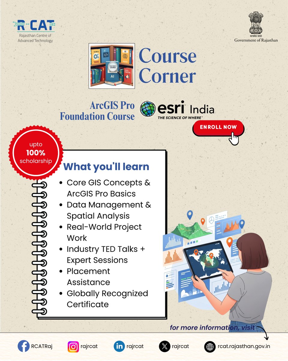
ArcGIS Pro Foundation Course at RCAT Gain in-demand GIS skills, hands-on project experience, and a globally recognized certificate — with up to 100% scholarship. #RCAT #ArcGISPro #GISTraining #SkillDevelopment #GovtInitiative #GeospatialSkills #DigitalIndia #CareerReady

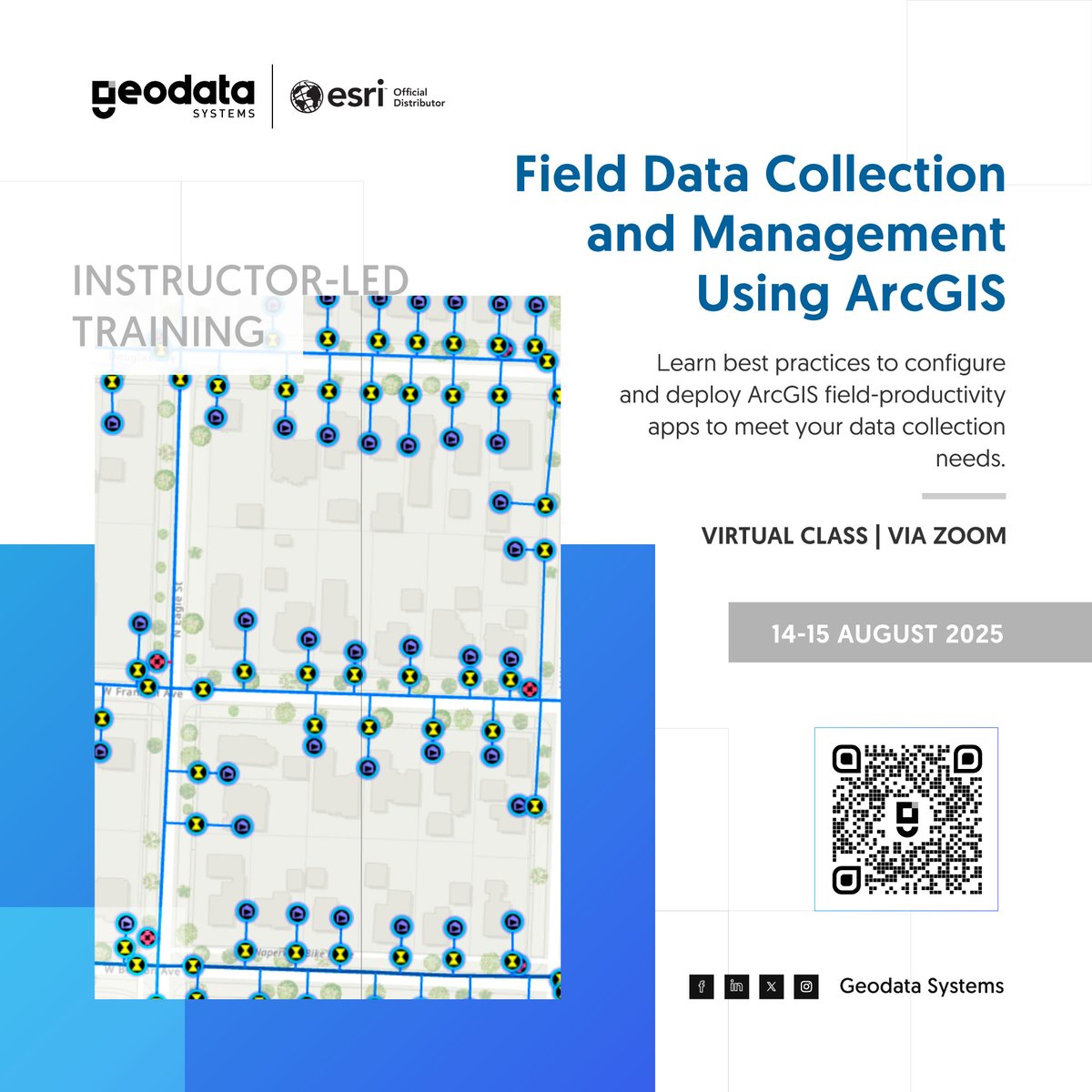
Streamline your field data workflow with ArcGIS! Learn to collect accurate, real-time data and monitor fieldwork using your mobile device in our instructor-led training. 👉 Enroll now: geodatasystems.info/fida-aug-train… #DataCollection #GISTraining

🚨 We Are LIVE! GeoCode 2025 is happening now. Join us as we dive into GIS, Python, and climate solutions with industry experts! 🌍💻 🕓 Happening Now | 📍 Google Meet 🎓 Free + Certificate of Participation 👉 Jump in here: meet.google.com/ees-hrpx-mqk #GeoCode2025 #GISTraining

🚨 Learn GIS. Build Real-World Skills. Join our hands-on training at Geoinfo Academy and master mapping, spatial analysis, and data visualization using QGIS & ArcGIS. 📍 Lagos, Abuja 📞 +234 707 070 8909 🌐 geoinfotech.ng #GISTraining #GeoinfoAcademy #ArcGIS #GeoSkills

FREE | 🧾 Certificate Included For more information visit: sites.google.com/ucem.ug/geocod… 🚀Let’s go change the map. #GeoCode2025 #GISTraining
📍 GIS in Action! Training the future of geospatial intelligence at Geoinfo Academy. 👉 Join our next training today! 📞: +234 707 070 8909 🌐: geoinfoacademy.com #GISLife #GeospatialAcademy #GISTraining #Geoinfotech


🎓 Looking for tailored GIS training? Our private courses are designed to meet your team's unique needs, whether you're building foundational skills or exploring advanced workflows. Find out more: hubs.ly/Q03ypBxB0 #GIStraining #PrivateTraining #GeospatialSkills
🎯 Whether you're in government, academia, or business — our goal is to equip you with skills that drive innovation and smart decision-making. 🔷 #CliffordGeoConsult #CapacityDevelopment #GISTraining #RemoteSensing #GeospatialSkills #ProfessionalWorkshops #TheScienceOfWhere


#AIILSG successfully conducted a 3-day #GISTraining Program under #AMRUT in #Kolkata The training was held at ILGUS Bhavan and brought together engineers and ULB officials to build capacity in geospatial planning for better #urbangovernance #capacitybuilding #sustainablecities
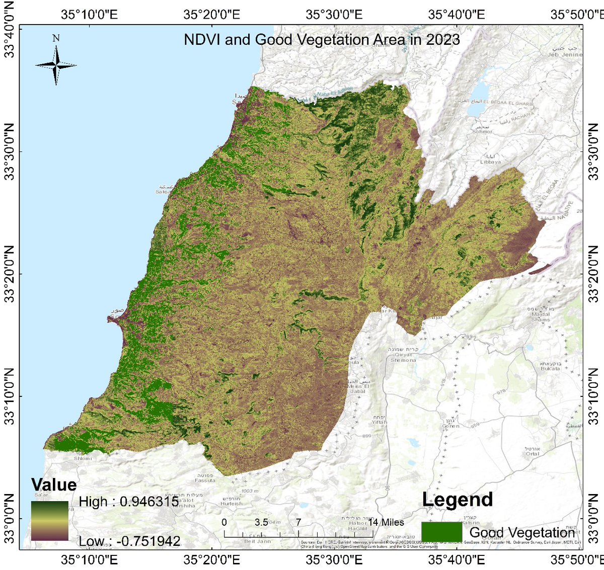
Vegetation analysis using soil moisture data is a powerful approach in remote sensing and environmental monitoring. Soil moisture plays a critical role in plant growth, affecting vegetation health, distribution, and productivity. #GoogleEarthEngine #RemoteSensing #GIStraining
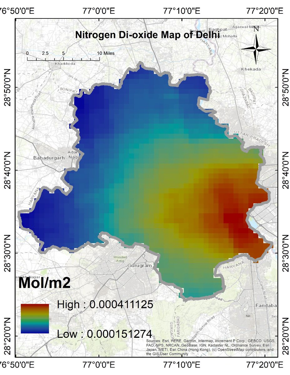
Air Quality Monitoring with Remote Sensing: Nitrogen Dioxide (NO₂) The Registration details: studyhacksgeospatial.com/google-earth-e… #GoogleEarthEngine #RemoteSensing #GIStraining #EarthObservation #SatelliteData #OnlineTraining #GEEtraining #GeospatialAnalysis #NDVI #LandCoverMapping
At An Garda Síochána, a private #ArcGISPro course has empowered staff to deliver new digital mapping services, reducing paper map requests by nearly 50%! Discover the impact of #LearningServices in our latest case study. @gardainfo #GISTraining @EsriUK ow.ly/rLhU50X6jP8
#GISTraining | Last few spots left for the "25th Training on Basics of Remote sensing and GIS", to be organised by #Aaranyak from 15-20 May. #GIS Check out the poster for details-
If your workforce plans to attend our instructor-led courses this year, we want to make it easier for you.💡💻 Simplify budget planning by purchasing an Esri Training Pass. Learn more at esri.social/MA8G50QM5LM #GIStraining #ArcGIS #GIS
GIS Training Concludes at BU Geology Department itdcindia.com/bu-geology-dep… #BUGeology #GISTraining #Geoscience #SkillDevelopment #MappingTechnology #GeologyEducation #BhopalUniversity
Google Earth Engine Tutorial: Split-Layer for Comparing Different Year LST MAP Tutorial Link: youtu.be/FENCYGQyayw The Registration details: studyhacksgeospatial.com/google-earth-e… #GoogleEarthEngine #RemoteSensing #GIStraining #EarthObservation #SatelliteData #OnlineTraining
Today, Namami Gange organized a training programme on the topic "Continuously Operating Reference Centre Stations Servics & Application and Usage of Geoid Model" under the GIS Cell & General Knowledge Centre. #GISTraining #GeoidModel #KnowledgeSharing
In our two-day instructor-led course on ArcGIS Survey123, you'll learn advanced Survey123 workflows that will accelerate your data collection process and enhance the quality of your results. Enrol now: ow.ly/mXqs50WNxZO #GIS #ArcGISSurvey123 #GISTraining

Hear how Kevin recently passed the Enterprise Admin Professional certification exam and solidified his GIS expertise. Grow professionally and represent your employer more credibly and reliably. Check it out: esri.social/Z4sa50O6hZk #ArcGISEnterprise #GIStraining @EsriTraining

📢 Registration Open for a 7-day complete online live training on Google Earth Engine (GEE) for Remote Sensing and GIS Analysis Registration info: studyhacksgeospatial.com/google-earth-e… #GoogleEarthEngine #RemoteSensingTraining #GIStraining #GeospatialAnalysis #EarthObservation #LULCmapping
📢 Registration is now open for the 32nd Batch of 7-day comprehensive online live training on Google Earth Engine For more information about registration, visit our website: studyhacksgeospatial.com/google-earth-e… #GoogleEarthEngine #RemoteSensingTraining #GISTraining #GeospatialAnalysis
Unlock practical GIS & Remote Sensing skills in just 7 days. Hands-on, certified and guided by Geoidex experts. 👉 Register today and level up your geospatial career! @GeoidexLTD #gistraining @RCMRD_ @MineNewsAfrica
🚨 Registration Now Open! 🚨 7-Day Online Live Training on Google Earth Engine (GEE) for Remote Sensing & GIS Analysis. 📆 Starts: 20th June 2025📍 No Coding Experience Needed! #GoogleEarthEngine #RemoteSensing #GISTraining #EarthObservation #GeospatialAnalysis #MachineLearning
Want to turn data into decisions? Join Esri Canada's Working with ArcGIS Dashboards course. Learn to build dashboards that drive clarity & action. Take the course: ow.ly/Fc2x50WG4Sm #ArcGISDashboards #GISTraining #EsriCanada #SpatialIntelligence #ArcGISOnline
Get #premium #GIS training for less. Our discounted trainings are still ongoing. So whether you are just starting out, looking to advance your skills, or aiming to master GIS, we have the perfect course for you. For more info,call 02092922821 #GISTraining #CareerGrowth
🛰️Ready to level up your GIS skills? Join our October training sessions. Spots fill fast, so grab yours today: hubs.ly/Q03KvnmQ0 #GIStraining #GIS #GISAustralia
🎓 Looking for tailored GIS training? Our private courses are designed to meet your team's unique needs, whether you're building foundational skills or exploring advanced workflows. Find out more: hubs.ly/Q03ypBxB0 #GIStraining #PrivateTraining #GeospatialSkills

Something went wrong.
Something went wrong.
United States Trends
- 1. #GrandEgyptianMuseum 25.9K posts
- 2. #GEM𓅓 7,181 posts
- 3. #Talus_Labs 1,018 posts
- 4. #capcutlovers N/A
- 5. Game 7 1,460 posts
- 6. Happy New Month 180K posts
- 7. jungkook 807K posts
- 8. Nigeria 422K posts
- 9. Kawhi 8,390 posts
- 10. vmin 4,637 posts
- 11. GenG 11.6K posts
- 12. Ja Morant 5,868 posts
- 13. #RUNSEOKJIN_epTOUR_ENCORE 341K posts
- 14. Barger 6,139 posts
- 15. Glasnow 6,857 posts
- 16. Shirley Temple N/A
- 17. Tinubu 46.4K posts
- 18. Justin Dean 2,688 posts
- 19. Halloween 2025 192K posts
- 20. Rojas 11.4K posts