#gistraining 搜尋結果

Vegetation analysis using soil moisture data is a powerful approach in remote sensing and environmental monitoring. Soil moisture plays a critical role in plant growth, affecting vegetation health, distribution, and productivity. #GoogleEarthEngine #RemoteSensing #GIStraining
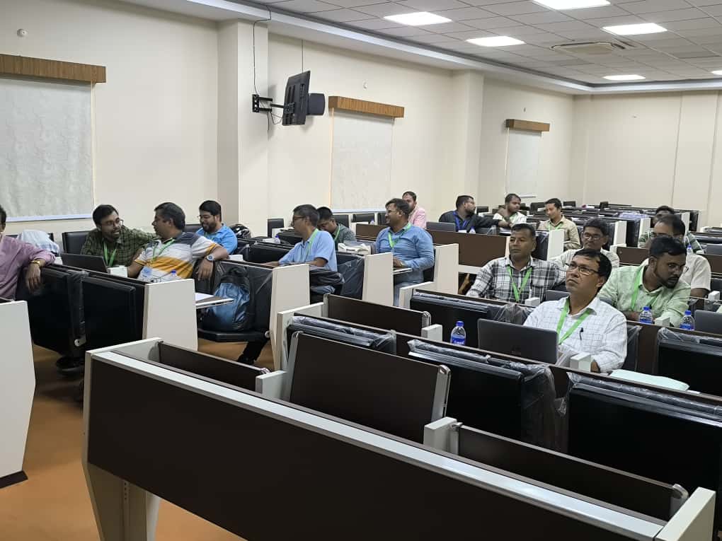
#AIILSG successfully conducted a 3-day #GISTraining Program under #AMRUT in #Kolkata The training was held at ILGUS Bhavan and brought together engineers and ULB officials to build capacity in geospatial planning for better #urbangovernance #capacitybuilding #sustainablecities


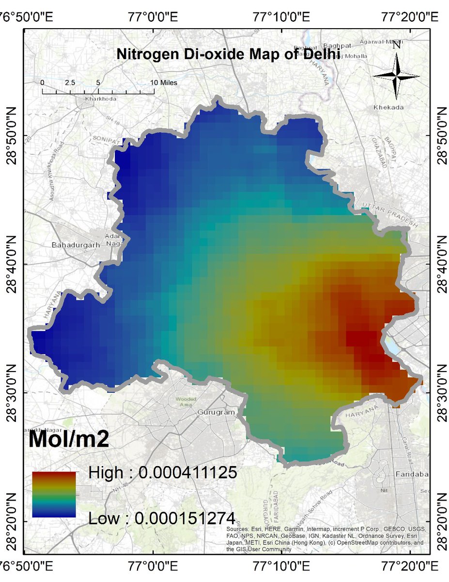
Air Quality Monitoring with Remote Sensing: Nitrogen Dioxide (NO₂) The Registration details: studyhacksgeospatial.com/google-earth-e… #GoogleEarthEngine #RemoteSensing #GIStraining #EarthObservation #SatelliteData #OnlineTraining #GEEtraining #GeospatialAnalysis #NDVI #LandCoverMapping

Today, Namami Gange organized a training programme on the topic "Continuously Operating Reference Centre Stations Servics & Application and Usage of Geoid Model" under the GIS Cell & General Knowledge Centre. #GISTraining #GeoidModel #KnowledgeSharing


"Geosense Research Lab is offering the second Online course of GIS. We hope that those interested in learning GIS will join this course and benefit from it." #GISCourse #LearnGIS #GISTraining #SpatialAnalysis #GeospatialEducation #GISSkills #GeospatialLearning #MapSkills #Geo

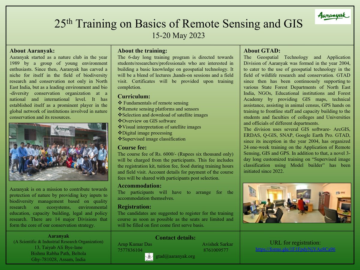
#GISTraining | Last few spots left for the "25th Training on Basics of Remote sensing and GIS", to be organised by #Aaranyak from 15-20 May. #GIS Check out the poster for details-

At An Garda Síochána, a private #ArcGISPro course has empowered staff to deliver new digital mapping services, reducing paper map requests by nearly 50%! Discover the impact of #LearningServices in our latest case study. @gardainfo #GISTraining @EsriUK ow.ly/rLhU50X6jP8

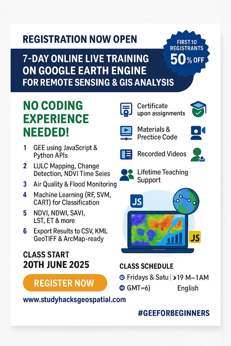
🚨 Registration Now Open! 🚨 7-Day Online Live Training on Google Earth Engine (GEE) for Remote Sensing & GIS Analysis. 📆 Starts: 20th June 2025📍 No Coding Experience Needed! #GoogleEarthEngine #RemoteSensing #GISTraining #EarthObservation #GeospatialAnalysis #MachineLearning
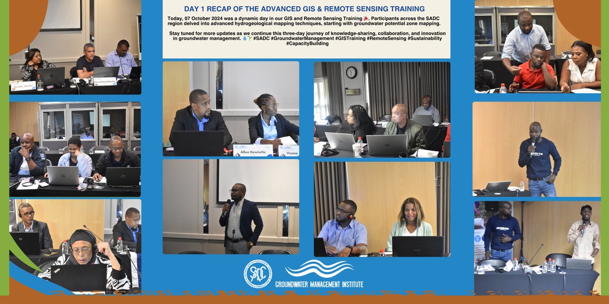
The first day of the Advanced GIS & Remote Sensing Training organized by the SADC -GMI and facilitated by Mzuzu University was a great start. Participants from the SADC region are actively engaged in advanced hydrogeological mapping techniques. #SADC #GISTraining #RemoteSensing
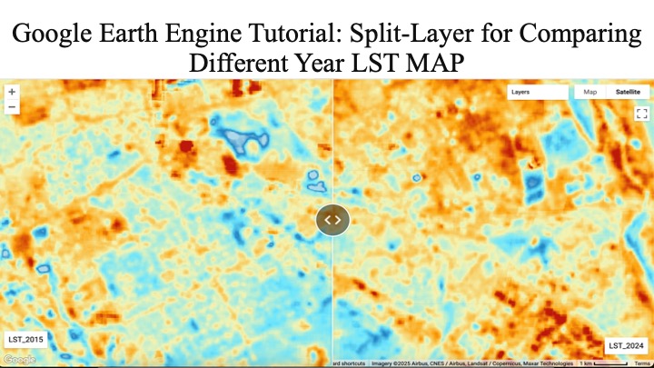
Google Earth Engine Tutorial: Split-Layer for Comparing Different Year LST MAP Tutorial Link: youtu.be/FENCYGQyayw The Registration details: studyhacksgeospatial.com/google-earth-e… #GoogleEarthEngine #RemoteSensing #GIStraining #EarthObservation #SatelliteData #OnlineTraining
📢 Registration is now open for the 32nd Batch of 7-day comprehensive online live training on Google Earth Engine For more information about registration, visit our website: studyhacksgeospatial.com/google-earth-e… #GoogleEarthEngine #RemoteSensingTraining #GISTraining #GeospatialAnalysis


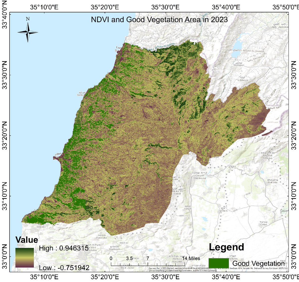
Exciting news from GEOSAR RWANDA! Today's training delved into the Normalized Difference Vegetation Index (NDVI), a key tool for assessing vegetation health. Join us again next Thursday for another enriching session #GEOSARRwanda #NDVI #GISTraining


Want to grow your GIS skills before the year wraps up? 🎯 We’ve just added new course dates, from beginner to advanced, there’s something for everyone. Spots fill fast! Register now 👉 hubs.ly/Q03QStcf0 #GIStraining #GIS #training

🛰️Ready to level up your GIS skills? Join our October training sessions. Spots fill fast, so grab yours today: hubs.ly/Q03KvnmQ0 #GIStraining #GIS #GISAustralia


Calling all spanish and french speaking users! These instructor-led #GIStraining classes offer software users the opportunity to expand their #GIS knowledge. By completing the program, you'll receive the official certificate: ow.ly/MXoy50QsuNX


Unlock your potential and elevate your productivity with ArcGIS Pro! Join our #GISTraining class to extend your knowledge, master ArcGIS Pro, and explore essential GIS workflows. 📅 Enroll now and start your journey to becoming an ArcGIS Pro whiz!

📢 Registration Open for a 7-day complete online live training on Google Earth Engine (GEE) for Remote Sensing and GIS Analysis Registration info: studyhacksgeospatial.com/google-earth-e… #GoogleEarthEngine #RemoteSensingTraining #GIStraining #GeospatialAnalysis #EarthObservation #LULCmapping

Ever wondered about Urban Heat Islands? #GeosarRwanda explored this hot topic in our recent training session! 🌎🌡️ Understanding how cities are impacted by rising temperatures. Huge thanks to our Geosar members for their active participation! @Staytuned🤝 #UHI #GISTraining


In our two-day instructor-led course on ArcGIS Survey123, you'll learn advanced Survey123 workflows that will accelerate your data collection process and enhance the quality of your results. Enrol now: ow.ly/mXqs50WNxZO #GIS #ArcGISSurvey123 #GISTraining


🚀 Whether you’re in urban planning, environmental management, or land administration, our expert-led trainings are designed to bridge the gap between theory and real-world application. #CliffordGeoConsult #GISTraining #CapacityBuilding #ProfessionalWorkshops #GeospatialSkills

Want to grow your GIS skills before the year wraps up? 🎯 We’ve just added new course dates, from beginner to advanced, there’s something for everyone. Spots fill fast! Register now 👉 hubs.ly/Q03QStcf0 #GIStraining #GIS #training
#AIILSG successfully conducted a 3-day #GISTraining Program under #AMRUT in #Kolkata The training was held at ILGUS Bhavan and brought together engineers and ULB officials to build capacity in geospatial planning for better #urbangovernance #capacitybuilding #sustainablecities
Our tailored GIS & Geospatial workshops equip professionals and organizations with the skills to manage spatial data, analyze trends, and make smarter, data-driven decisions. #CliffordGeoConsult #GISTraining #ProfessionalDevelopment #GeospatialCapacity #DataScienceWithGIS

At An Garda Síochána, a private #ArcGISPro course has empowered staff to deliver new digital mapping services, reducing paper map requests by nearly 50%! Discover the impact of #LearningServices in our latest case study. @gardainfo #GISTraining @EsriUK ow.ly/rLhU50X6jP8

Unlock practical GIS & Remote Sensing skills in just 7 days. Hands-on, certified and guided by Geoidex experts. 👉 Register today and level up your geospatial career! @GeoidexLTD #gistraining @RCMRD_ @MineNewsAfrica

🛰️Ready to level up your GIS skills? Join our October training sessions. Spots fill fast, so grab yours today: hubs.ly/Q03KvnmQ0 #GIStraining #GIS #GISAustralia
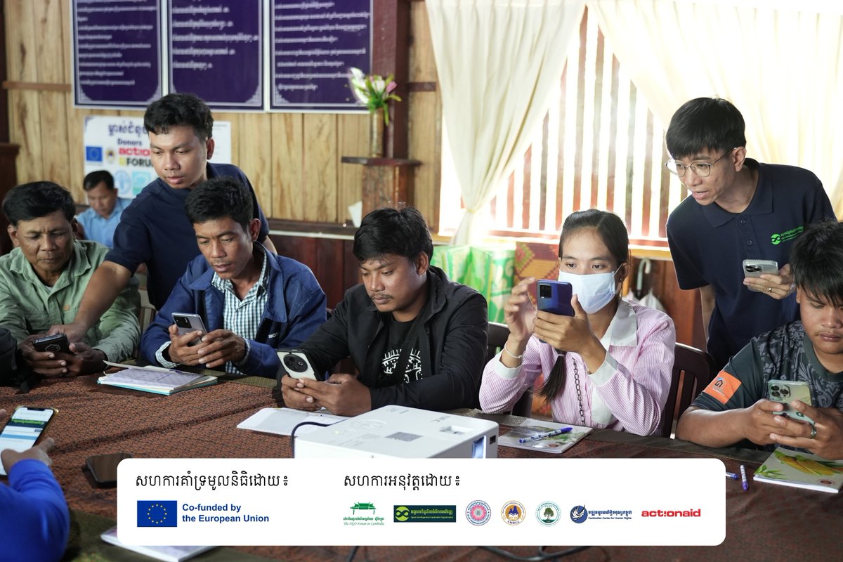
Open Development Cambodia (ODC) successfully conducted the Training Workshop on Community-Based Mapping on 1-2 July 2025, Kampot 🎉✨ #SCAEG #GISTraining #CSO #Mapping #CoastalArea #Avenza #ODC


In our two-day instructor-led course on ArcGIS Survey123, you'll learn advanced Survey123 workflows that will accelerate your data collection process and enhance the quality of your results. Enrol now: ow.ly/mXqs50WNxZO #GIS #ArcGISSurvey123 #GISTraining

GIS Training Concludes at BU Geology Department itdcindia.com/bu-geology-dep… #BUGeology #GISTraining #Geoscience #SkillDevelopment #MappingTechnology #GeologyEducation #BhopalUniversity

Want to turn data into decisions? Join Esri Canada's Working with ArcGIS Dashboards course. Learn to build dashboards that drive clarity & action. Take the course: ow.ly/Fc2x50WG4Sm #ArcGISDashboards #GISTraining #EsriCanada #SpatialIntelligence #ArcGISOnline


Unlock geoinformatics for smart decisions & sustainability! Geoinfo Academy offers hands-on training in GIS, drones, Python & more in Lagos & Abuja. Enroll now! 📞 +234 707 070 8909 | 🌐 geoinfoacademy.com #GISTraining #DroneMapping #GeoTech
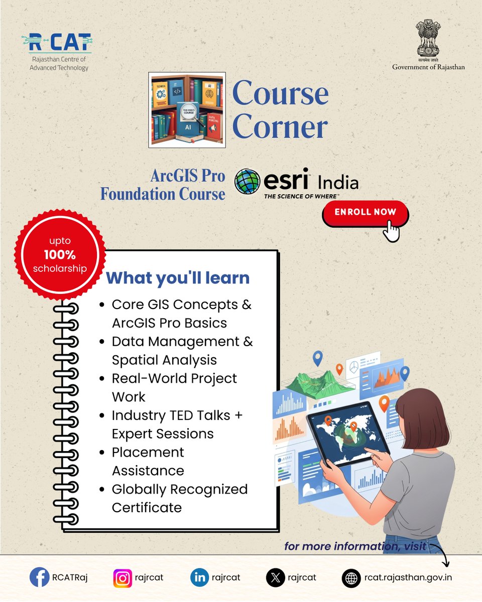
ArcGIS Pro Foundation Course at RCAT Gain in-demand GIS skills, hands-on project experience, and a globally recognized certificate — with up to 100% scholarship. #RCAT #ArcGISPro #GISTraining #SkillDevelopment #GovtInitiative #GeospatialSkills #DigitalIndia #CareerReady
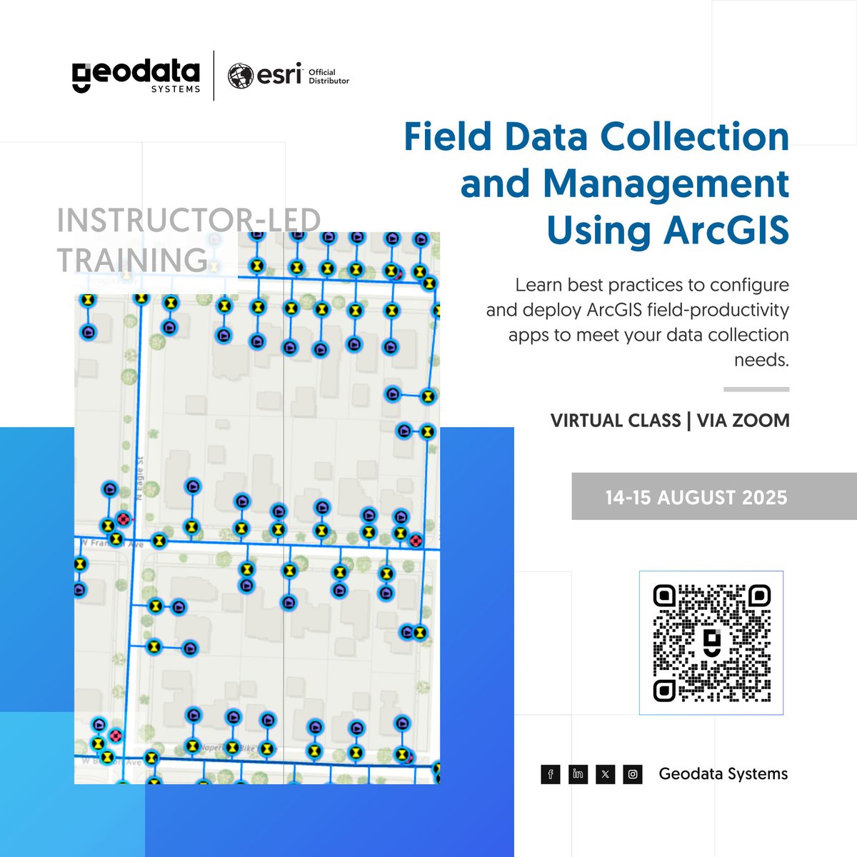
Streamline your field data workflow with ArcGIS! Learn to collect accurate, real-time data and monitor fieldwork using your mobile device in our instructor-led training. 👉 Enroll now: geodatasystems.info/fida-aug-train… #DataCollection #GISTraining

🚨 We Are LIVE! GeoCode 2025 is happening now. Join us as we dive into GIS, Python, and climate solutions with industry experts! 🌍💻 🕓 Happening Now | 📍 Google Meet 🎓 Free + Certificate of Participation 👉 Jump in here: meet.google.com/ees-hrpx-mqk #GeoCode2025 #GISTraining

🚨 Learn GIS. Build Real-World Skills. Join our hands-on training at Geoinfo Academy and master mapping, spatial analysis, and data visualization using QGIS & ArcGIS. 📍 Lagos, Abuja 📞 +234 707 070 8909 🌐 geoinfotech.ng #GISTraining #GeoinfoAcademy #ArcGIS #GeoSkills

FREE | 🧾 Certificate Included For more information visit: sites.google.com/ucem.ug/geocod… 🚀Let’s go change the map. #GeoCode2025 #GISTraining
📍 GIS in Action! Training the future of geospatial intelligence at Geoinfo Academy. 👉 Join our next training today! 📞: +234 707 070 8909 🌐: geoinfoacademy.com #GISLife #GeospatialAcademy #GISTraining #Geoinfotech


🎓 Looking for tailored GIS training? Our private courses are designed to meet your team's unique needs, whether you're building foundational skills or exploring advanced workflows. Find out more: hubs.ly/Q03ypBxB0 #GIStraining #PrivateTraining #GeospatialSkills
🎯 Whether you're in government, academia, or business — our goal is to equip you with skills that drive innovation and smart decision-making. 🔷 #CliffordGeoConsult #CapacityDevelopment #GISTraining #RemoteSensing #GeospatialSkills #ProfessionalWorkshops #TheScienceOfWhere


#AIILSG successfully conducted a 3-day #GISTraining Program under #AMRUT in #Kolkata The training was held at ILGUS Bhavan and brought together engineers and ULB officials to build capacity in geospatial planning for better #urbangovernance #capacitybuilding #sustainablecities
🚀 Whether you’re in urban planning, environmental management, or land administration, our expert-led trainings are designed to bridge the gap between theory and real-world application. #CliffordGeoConsult #GISTraining #CapacityBuilding #ProfessionalWorkshops #GeospatialSkills
Want to grow your GIS skills before the year wraps up? 🎯 We’ve just added new course dates, from beginner to advanced, there’s something for everyone. Spots fill fast! Register now 👉 hubs.ly/Q03QStcf0 #GIStraining #GIS #training
Something went wrong.
Something went wrong.
United States Trends
- 1. Cheney 114K posts
- 2. Election Day 117K posts
- 3. Logan Wilson 7,554 posts
- 4. #csm219 2,371 posts
- 5. Mamdani 548K posts
- 6. Shota 16.5K posts
- 7. GO VOTE 91.5K posts
- 8. New Jersey 194K posts
- 9. Cuomo 264K posts
- 10. Iraq 54.2K posts
- 11. #tuesdayvibe 2,441 posts
- 12. New Yorkers 80.8K posts
- 13. Good Tuesday 39.7K posts
- 14. Taco Tuesday 12.2K posts
- 15. #Election2025 2,892 posts
- 16. Rickey 1,847 posts
- 17. Rolex 17.4K posts
- 18. Virginia 178K posts
- 19. No ID 64K posts
- 20. Halliburton 5,054 posts