#mappingtools search results

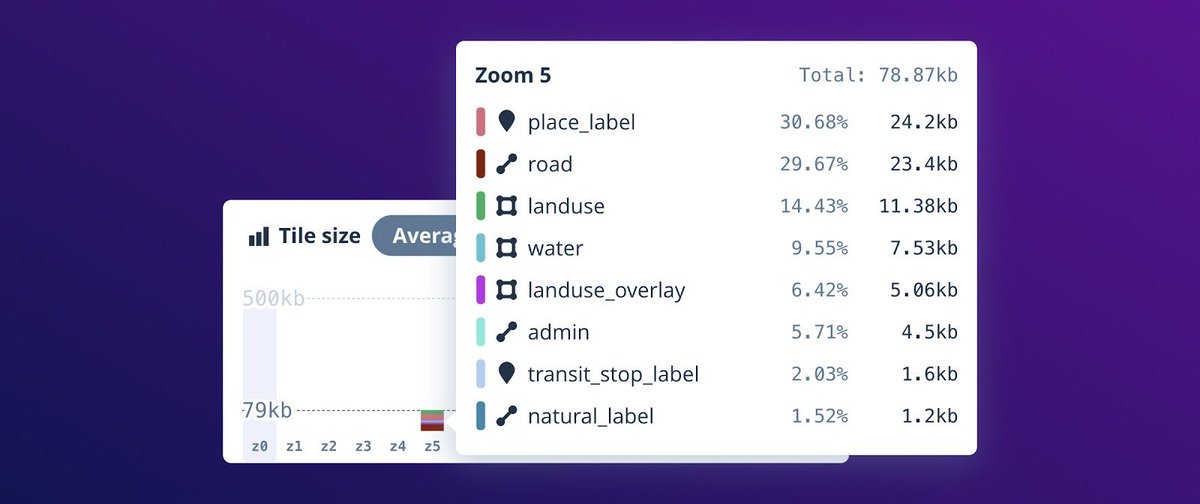
Gain unparalleled insight in your tilesets with the Tileset explorer, launched today! Visualize tileset statistics and metadata for deep understanding about your data distribution and size. buff.ly/391gYbC #mapbox #mappingtools


📍#GeoforGood23 Summit took place last week and the #SERVIRAmazonia team was well-represented 🙌🏼 The event gathered professionals worldwide using @Google #mappingtools for planetary #sustainability @googleearth @SERVIRGlobal @sig_gis @Imaflora @amazonacca 🌳 1/2


Explore les dashboards @TheLensOrg sur les données du labo. Extrêmement versatile; customisation des graph, exports (svg, data, etc)... #dataviz #bibliometrics #mappingtools #searchengines #ESR

Did you know? Our network of customers includes over 2.7 million registered #developers around the globe. Discover why developers love our powerful #mappingtools: mapbox.com/maps
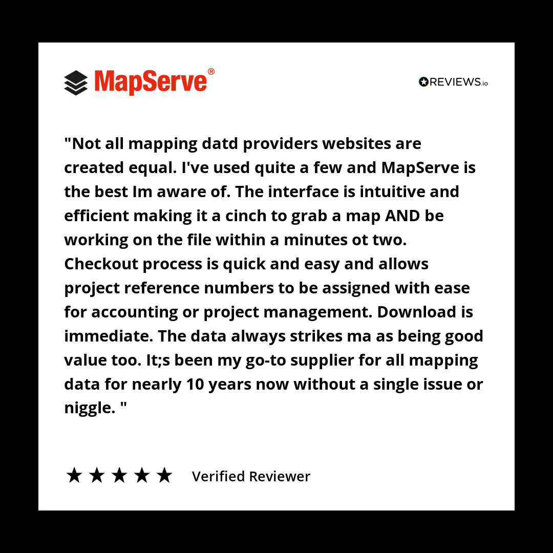
10 years. Zero issues. That’s what we aim for. And it’s why professionals keep coming back. #TestimonialTuesday #MappingTools #CustomerLoyalty #PlanningWorkflows #ArchitectsUK #MapServe #TrustedByProfessionals

State technology experts want Tennesseans to use new #mappingtools they've made available, and have now produced instructional videos to help. More at greeneville.com/news.

Have you been using our Transpo Injury Mapping System? Updated TIMS website: tims.berkeley.edu #trafficsafety #mappingtools #SWITRS


A lot of surveyors are still using outdated tools to calibrate land boundaries. We @adollatech are building something different — smart, fast & field-ready. If you work in mapping or boundary validation, you’ll want to keep an eye on this. #SurveyTech #MappingTools #LandSurvey


Have you used our Transpo Injury Mapping System? TIMS #MappingTools allow users to access, view & map collision data tims.berkeley.edu

🗺️ New Map Alert! The Namibia Topographic Map is now available on the SAGTA Map Downloader — plus two new projects: 📚 South Africa & 🌍 Global Map Projects 🔗Visit the SAGTA Map Downloader: maps.sagta.org.za #Kartoza #GIS #MappingTools


🌍 Need to visualize your data quickly? Check out our guide on creating quick maps for free! Transform your information into engaging visuals in no time. #DataVisualization #MappingTools #FreeResources ift.tt/17CWJre #byAI

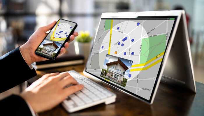
Unlock property ownership insights with mapping tools, GIS, and public records! 🏘️ Discover how you can simplify real estate research and transactions in our latest guide. tycoonstory.com/why-mapping-to… #realestate #gis #mappingtools #propertyownership #realestateinvesting

📊 Get the inside scoop on Java mapping frameworks. Our analysis of MapStruct vs. ModelMapper reveals their strengths and weaknesses. #JavaDev #MappingTools buff.ly/4a8POhj
🌟 MapStruct offers type-safe, generated code, while ModelMapper provides flexible runtime mapping. See how they stack up in our analysis! #JavaDev #MappingTools buff.ly/4a8POhj

Need a Geographic Geometry Generator? Check this one created by one of our Brigade members. ow.ly/tlTz30k9EGD #mappingtools

Anyone know a good (free) global by country thematic mapping tool for Mac? #thematicmaps #mappingtools
Did you know that you can print your WellDatabase map? Use the print tool to create images up to 24x36. Learn more in the following article: hubs.la/Q02R5ZW90 #oilandgas #datamanagement #mappingtools #energyindustry

The best relationship mapping tools used for businesses. [[Link]] #business #mappingtools bit.ly/3eHAw6l

10 years. Zero issues. That’s what we aim for. And it’s why professionals keep coming back. #TestimonialTuesday #MappingTools #CustomerLoyalty #PlanningWorkflows #ArchitectsUK #MapServe #TrustedByProfessionals
📍#GeoforGood23 Summit took place last week and the #SERVIRAmazonia team was well-represented 🙌🏼 The event gathered professionals worldwide using @Google #mappingtools for planetary #sustainability @googleearth @SERVIRGlobal @sig_gis @Imaflora @amazonacca 🌳 1/2

New to GIS? Our ArcGIS Pro Intro course covers map navigation, data visualization, and spatial analysis—everything you need to build a strong foundation and unlock the power of ArcGIS. tcworkshop.com/pages/course-d… #ArcGISPro #MappingTools

Creating a Leaflet Map with Inset Globe buff.ly/1VPsHza #interactivemaps drive engagement #mappingtools
Gain unparalleled insight in your tilesets with the Tileset explorer, launched today! Visualize tileset statistics and metadata for deep understanding about your data distribution and size. buff.ly/391gYbC #mapbox #mappingtools

@AndeanAlliance shares at Story Map Event. How can #mappingtools tell a #story? @center4impact @MIIS_META_Lab
Did you know? Our network of customers includes over 2.7 million registered #developers around the globe. Discover why developers love our powerful #mappingtools: mapbox.com/maps

Recently released #mappingtools from @facebook will help travelers, first responders, and community leaders make sense of #unpavedroads. blog.midwestind.com/facebooks-new-…

A lot of surveyors are still using outdated tools to calibrate land boundaries. We @adollatech are building something different — smart, fast & field-ready. If you work in mapping or boundary validation, you’ll want to keep an eye on this. #SurveyTech #MappingTools #LandSurvey

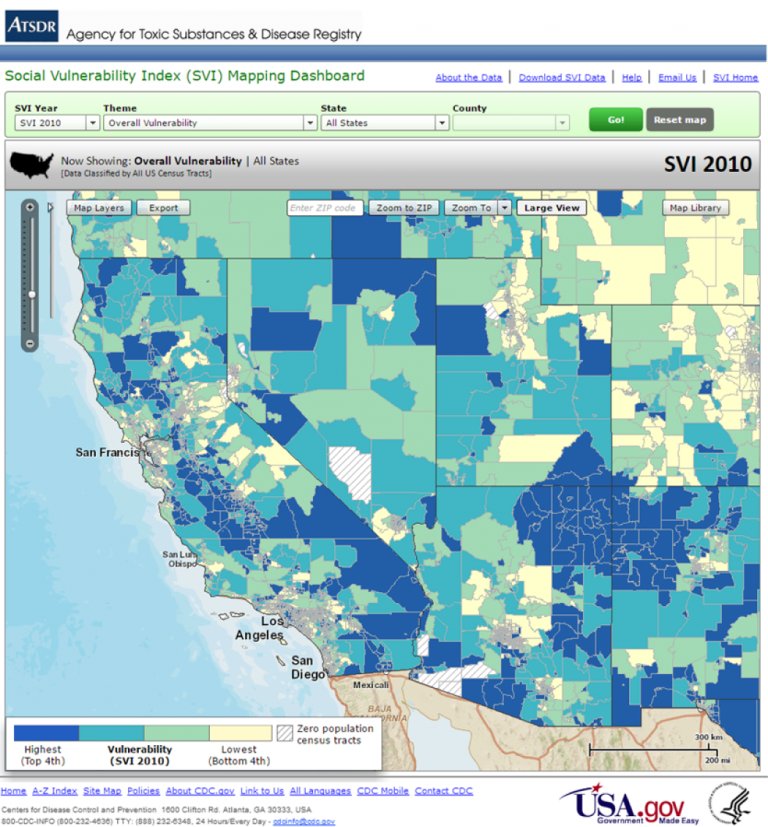
#MappingTools identify potential climate-related risk factors to protect locations and groups of people. bit.ly/2kFcY8R @CDCgov

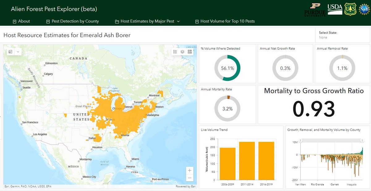
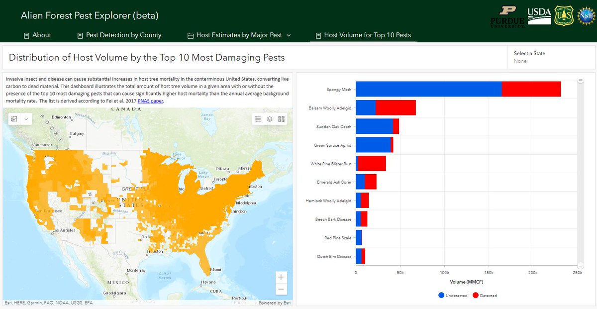
Check out the Alien Forest Pest Explorer, an interactive tool providing pest distribution for 89 pests. Look by county, specific pest, or top 10 pests. #Pests #MappingTools mapsweb.lib.purdue.edu/AFPE/?_ga=2.19…

Looking for the perfect GPS for surveying & mapping? 🛰️ Get expert tips + top picks today! 🛒 Shop now: geoinfostore.com #GPSDevice #Surveying #MappingTools #GeoStore #Geoinfotech

State technology experts want Tennesseans to use new #mappingtools they've made available, and have now produced instructional videos to help. More at greeneville.com/news.

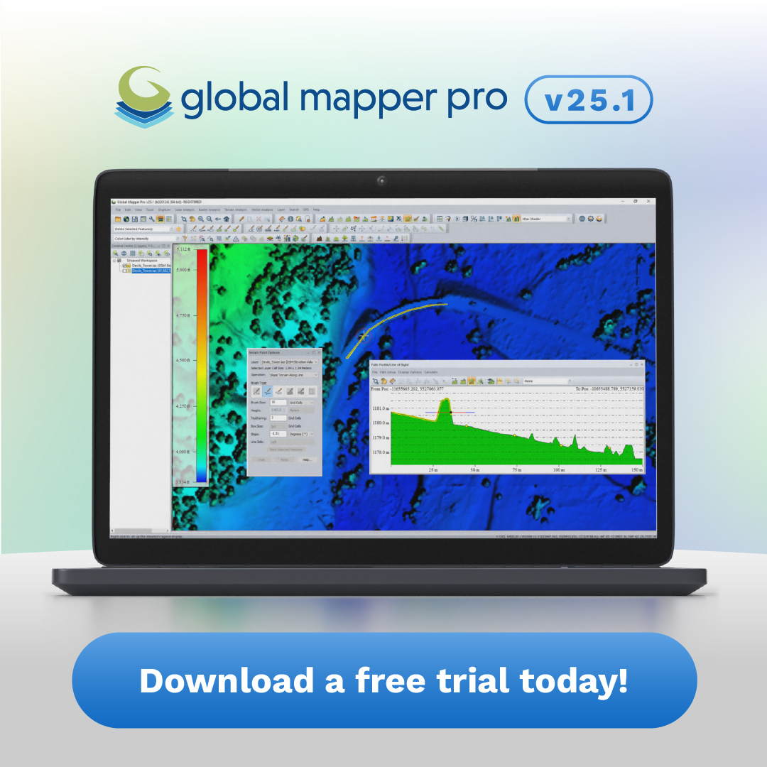
Global Mapper Pro v25.1 is available! 🌎 Download a free trial and test out the all-in-one GIS software: ow.ly/wB8W50QqlTp - #GlobalMapper #mappingtools #geospatial #mapping #GISsoftware #spatialanalysis

Fin de la deuxième journée de la session de formation en collecte de données géographiques. Les modules du jours ont porté sur la prise de main en #JOSN et du #Mappingtools. Cette formation s'inscrit dans le cadre du projet #Opencities financé par la @Banquemondiale.


Unlock property ownership insights with mapping tools, GIS, and public records! 🏘️ Discover how you can simplify real estate research and transactions in our latest guide. tycoonstory.com/why-mapping-to… #realestate #gis #mappingtools #propertyownership #realestateinvesting
Have you been using our Transpo Injury Mapping System? Updated TIMS website: tims.berkeley.edu #trafficsafety #mappingtools #SWITRS

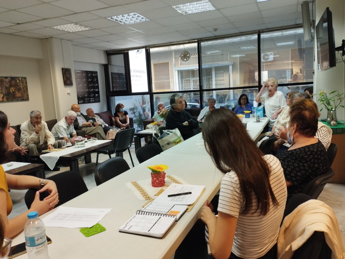
Α new project just began! Athens: A city for all ages In the following months together with the Friendship Club of Kypseli, we will record the everyday needs of the elderly in the neighbourhoods of Kypseli, through #exploratorywalks and other #mappingtools. #TIMA #PointsofSupport


Global Mapper Pro v25.1 is available! 🌎 Download a free trial and test out the all-in-one GIS software: ow.ly/wB8W50QqlTp - #GlobalMapper #mappingtools #geospatial #mapping #GISsoftware #spatialanalysis
Something went wrong.
Something went wrong.
United States Trends
- 1. Good Wednesday 21.1K posts
- 2. #MAYATVAWARDS2025 554K posts
- 3. Hump Day 9,191 posts
- 4. Huda 13.2K posts
- 5. #NationalCatDay N/A
- 6. #hazbinhotelseason2 13.9K posts
- 7. South Korea 94.6K posts
- 8. #PutThatInYourPipe N/A
- 9. Clippers 14.8K posts
- 10. Namjoon 199K posts
- 11. Jay Z 6,738 posts
- 12. Harden 10.9K posts
- 13. Olandria 28.4K posts
- 14. Eminem 12.3K posts
- 15. Jake Tapper 23.4K posts
- 16. Nvidia 73.9K posts
- 17. Kawhi 3,856 posts
- 18. #RHOSLC 8,449 posts
- 19. Ty Lue 1,577 posts
- 20. New World 92.2K posts