
내가 좋아할 만한 콘텐츠


🎥 Watch our new video, revealing how LuxGeospatial revolutionizes geospatial monitoring! Experience monitoring, precision, and sustainability like never before. Join us on this transformative journey! #Geospatial #Innovation #Safety #Sustainability #Luxembourg

"[We] decided that animation was the best method to explain the theory, approach and challenges inherent in Sky River," said Blauvelt. "We reached out to an animator and began the process of storyboarding to determine what #geospatial data would be required."

Piplup Habitat (2014): Another old (contest) map. This one is supposed to be a habitat for the piplup line. It's also one of my early experiments with tileset spriting lol. #pokemon #pokemonFanArt #mapping #pokemonMap #pixelart #gameArt


My Version 3 Of A Map🗺️ of 1854 Cholera Outbreak in Soho, London 🇬🇧(A tribute to John Snow) data is from @sciremotesense's blog and @openstreetmap @OSMLondon And DSM From DEFRA #gischat #QGIS #Blender3d #Remotesensing #cartography #dataviz #mapping #b3d (1/5)


I wanted to duplicate @kylebarron2 effort using only @flatgeobuf & @cogeotiff without extra processing of @RustGeo #GeoArrow & @WasmWeekly. Use @turfjs if needed. The result: postholer.com/devmap/John-Mu… Uses COG at zoom level 1-14, FGB at >14. Click poly for area. #geospatial

Spatial Analysis: The Importance of Coordinate Systems w/ Melita Kennedy, @ProjectionWizz & @DrewsAtWork in SDCC Room 30A @ 1pm. #EsriUC #EsriUC2023 @EsriUC @ArcGISanalysis #ArcGIS #GIS #SpatialModels #GIS_algorithms #mapprojections #DataScience #mapping #geostatistics


#NJGF Utilities/Public Works Task Force meeting scheduled for Thu 7/13 is CANCELED. #gis #geospatial #technj
#NJGF Utilities/Public Works Task Force meeting on Thu 7/13 10a-noon. Learn more & RSVP: bit.ly/3HsN2Wp #gis #geospatial #technj

We have made more progress on @mindat API for #opendata and #opensciecne See how to start at here and links to #jupyter notebooks here mindat.org/a/how_to_get_m… @gene21d4 #mineralogy @EarthCube @NSF @EarthDataHelp We will present at @ESIPfed summer mtg next week.

Why can't utilities place all their geospatial data in a single central warehouse? Fabian Mäsch explains. hxgn.biz/3qtXrfH #geospatial #utilities #data hxgn.biz/3ObxVVO
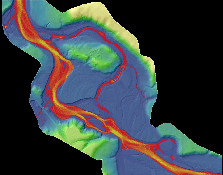
Data Dive: This image shows the Yellowstone River near the confluence of Elk Antler Creek in Wyoming. The image was made using the topobathymetric lidar-derived bare earth model and colored by elevation and water depth. #Yellowstone #Wyoming #Lidar #GIS #Geospatial

Instead of building your own #API capabilities, work with Precisely and leverage our #addressvalidation, #geocoding, #geospatial, and #dataenrichment APIs. Register for our #webinar on July 19 to learn more: okt.to/7dpyBL


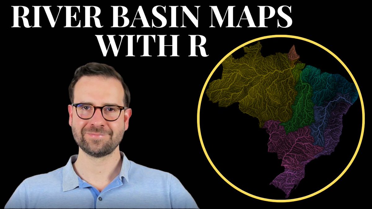
Another cool river basin map by @Steve_Tornes 🇨🇦 Follow my latest tutorial to create your own river basin maps of any country in the world 🏞️ 🔗youtu.be/HugGwjogPv0 #RStats #DataScience #tutorial #coding #geospatial #maps #dataviz
#NJGF Utilities/Public Works Task Force meeting on Thu 7/13 10a-noon. Learn more & RSVP: bit.ly/3HsN2Wp #gis #geospatial #technj

A big thank you to Chris Chiriattii from @DeloitteUS for being the keynote speaker for our #esriuc session: CapEx vs. OpEx: How to Account for Your Cloud Spend ☁️ @EsriUC @EsriPartners #gis #geospatial


📍Big news everyone! The Flex Mini just released and I could not be more excited to be able to talk about it now. Ask me anything ! 📍 Link: einpresswire.com/article/643865… #gischat #geospatial #atxgis

Here was an interesting #Python / #Pandas challenge, to find the most common languages spoken in Niagara Falls, where I live. Can you adapt this for your own location? How does it compare with my results? #Jupyter #JupyterNotebook #GitHub github.com/pbeens/Data-An…

Mapping galaxies! storymaps.arcgis.com/stories/d550dc… Oh these images are grand. #mapping #astronomy


United States 트렌드
- 1. The BONK 97.6K posts
- 2. FINALLY DID IT 425K posts
- 3. TOP CALL 4,556 posts
- 4. #MeAndTheeSeriesEP5 195K posts
- 5. AI Alert 2,654 posts
- 6. WILLIAMEST ROME 1ST MEET 101K posts
- 7. Token Signal 2,219 posts
- 8. #WilliamEst1stFMinRome 111K posts
- 9. Peter Greene 6,103 posts
- 10. #LingOrm2ndMeetInVietnam 431K posts
- 11. Check Analyze N/A
- 12. LINGORM VIETNAM MEET 429K posts
- 13. The WET 361K posts
- 14. Market Focus 2,829 posts
- 15. Caine 69.5K posts
- 16. My Hero Academia 34.6K posts
- 17. Dick Van Dyke 15.4K posts
- 18. The Mask 32.3K posts
- 19. Pedri 37.6K posts
- 20. Seth Rogan 1,034 posts
내가 좋아할 만한 콘텐츠
-
 SpatioTemporal Asset Catalog
@STACspec -
 Qiusheng Wu
@giswqs -
 Remote Sensing MDPI
@RemoteSens_MDPI -
 PostGIS
@postgis -
 Justin Braaten
@jstnbraaten -
 Earth Blox
@EarthBlox -
 GRSS IADF
@GrssIadf -
 IEEE Geoscience and Remote Sensing Society
@IEEE_GRSS -
 Radiant Earth
@OurRadiantEarth -
 Ujaval Gandhi
@spatialthoughts -
 OpenGeoHub Foundation
@opengeohub -
 ISPRS IJGI
@ISPRS_IJGI
Something went wrong.
Something went wrong.