#gischat 搜尋結果

🗺️ Making maps with R 🗺️ Examples of static and interactive maps and mobility flows using {ggplot2}, {leaflet}, {mapview}, {tmap} & {flowmapblue} 👉 paulamoraga.com/book-spatial/m… #rstats #rspatial #GISchat #datascience


I’ve created a Russian-language “Soviet atlas”-style map of Middle-earth. You can download it for free in high resolution: disk.yandex.ru/d/R8YXcS9WPtVC… #gischat


Learn how to publish @QGIS maps to the web with the ‘Add to Felt’ plugin. youtu.be/-mUdqQ4FX6E Styled rasters and vectors import seamlessly! 🗺️ #GIS #GISchat

Want to learn how to analyze and visualize spatial data in the social sciences? I'm now offering my Introduction to Spatial Data and R as a GIS course on #InStats in March 2025, instats.org/seminar/introd…, more courses and info at nickbearman.com/training-cours… #GISchat


Back in my student days, the urban design class taught a trick of adding “fake shadows” into maps quickly in Photoshop by: 1. Duplicate the building polygons 2. Offset it by a tiny distance 3. Change it to black & put it behind Same technique can be used in QGIS too #gischat


Hey Geography lovers! 🌎 I've released a new game about maps! Want to try it out? Check the post below! Let me know what you think about it! ❤️ #geo #geography #GISchat #Worldle #MapPorn


A cartography reminder that #QGIS offers a powerful “Render as HTML” option which allows you to format text and labels in incredibly creative ways #gischat

I am looking for the best open-source algorithm for converting a building raster to vector without oversimplifying the outlines, something better than the minimum rotated rectangle algorithm. Let me know if you have any recommendations. Thanks. #geospatial #gischat #building…

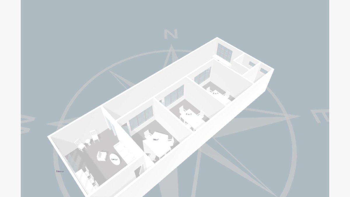
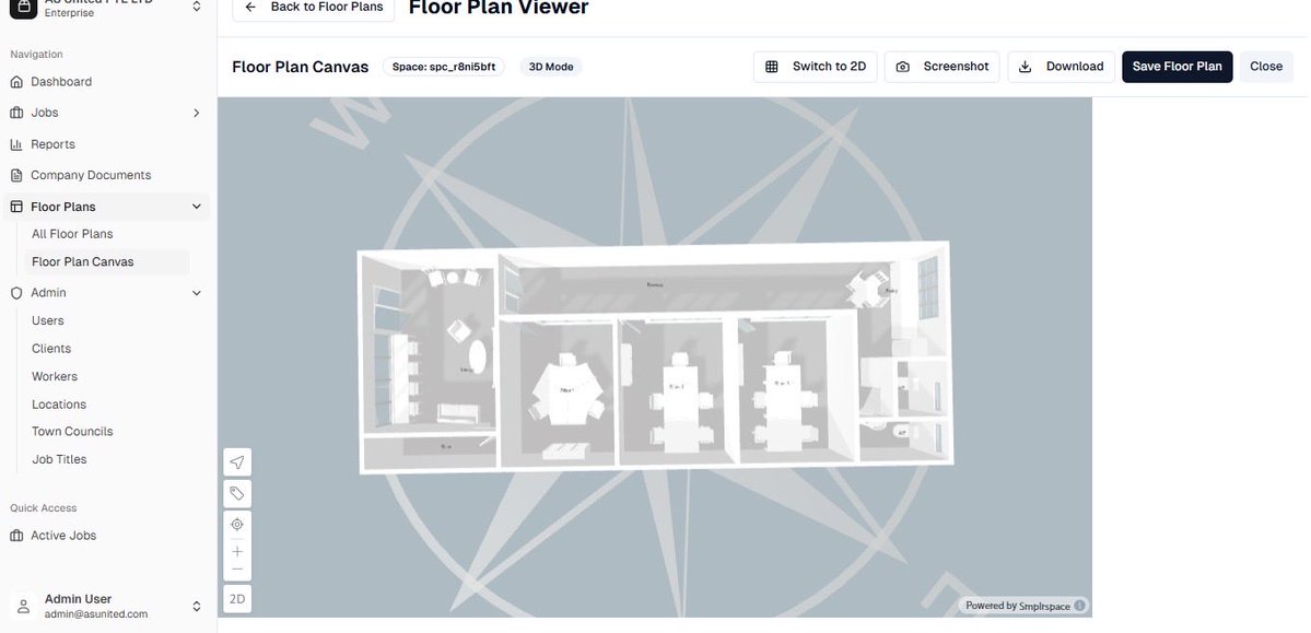
How cool…😍in love with what i do❤️🔥…Created this system - dynamic indoor mapping + interactive floor plan project support...incorporated with gis👌🏾 #gischat #geospatial


Incredible what you can find if you zoom in far enough on that Walz viral pic. Don't tell @John_M_Nelson #gischat

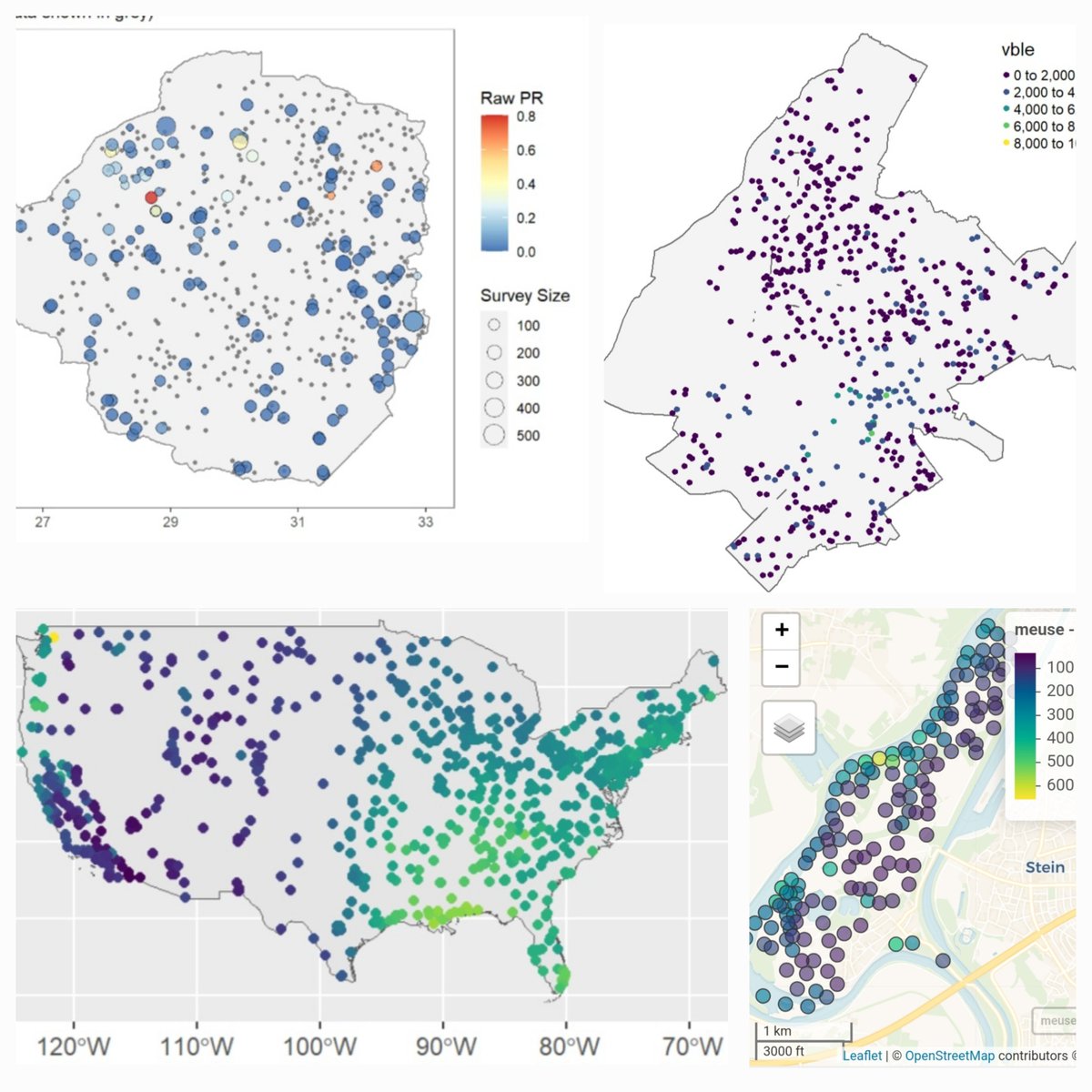
Spatial prediction methods for geostatistical data such as disease prevalence 🪰, precipitation 🌧️, contaminants 🏭, household prices 🏡 🔗paulamoraga.com/book-spatial/s… #rstats #rspatial #GISChat
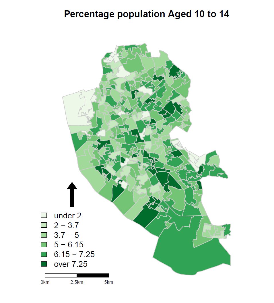
Working on slides for Intro to Spatial Data and R as a GIS course on #InStats, inc. classification & why it's important, which gives me the chance to show this great graphic from James Cheshire @spatialanalysis theconversation.com/next-slide-ple…, details at instats.org/seminar/introd… #GISchat


Hooray! In one of the best feel-good stories of the year, the little puppy who wandered onto the Esri campus lost and scared, and cared for by Esri employees over several weeks, has now been officially adopted BY an Esri employee and given the name “LILO”!!!🥰 #GISchat


What does your "I'll just give it some rough styling to sense check it as I go" cartography say about you? #gischat Mine says disco.

Experimenting the effect of applying both drop shadow and faded vignette to an area of interest in various basemaps in @ArcGISOnline #gischat
Last chance! Want to learn how to analyze and visualize spatial data in the social sciences? I'm now offering my Introduction to Spatial Data and R as a GIS course on #InStats on 4th & 5th March 2025, next week! instats.org/seminar/introd… #GISchat
#Thread (Mini) So Last year I crafted another climateR🌤️🌧️ tutorial using R programming which In this tutorial I've tried to make a shinyapp which non coders could use to quickly visualize annual map #gischat #cartography #GIS #climate #geospatial #dataviz #R #rspatial
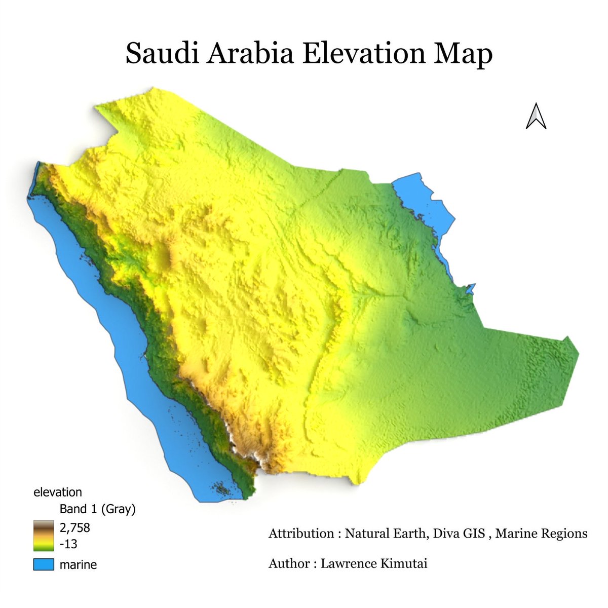
#Thread [Update] So Last year I crafted a climateR🌤️🌧️ tutorial using R programming which In this tutorial I'm still going to use The Kingdom of Saudi Arabia 🇸🇦 and one of It's Province, I'll share GitHub link (1/4) #gischat #cartography #GIS #geospatial #dataviz #R #rspatial
![725Hemeed's tweet image. #Thread [Update] So Last year I crafted a climateR🌤️🌧️ tutorial using R programming which In this tutorial I'm still going to use The Kingdom of Saudi Arabia 🇸🇦 and one of It's Province, I'll share GitHub link (1/4) #gischat #cartography #GIS #geospatial #dataviz #R #rspatial](https://pbs.twimg.com/media/GJI64iJWsAAAOTa.jpg)
![725Hemeed's tweet image. #Thread [Update] So Last year I crafted a climateR🌤️🌧️ tutorial using R programming which In this tutorial I'm still going to use The Kingdom of Saudi Arabia 🇸🇦 and one of It's Province, I'll share GitHub link (1/4) #gischat #cartography #GIS #geospatial #dataviz #R #rspatial](https://pbs.twimg.com/media/GJI64zaXQAABU3_.jpg)
![725Hemeed's tweet image. #Thread [Update] So Last year I crafted a climateR🌤️🌧️ tutorial using R programming which In this tutorial I'm still going to use The Kingdom of Saudi Arabia 🇸🇦 and one of It's Province, I'll share GitHub link (1/4) #gischat #cartography #GIS #geospatial #dataviz #R #rspatial](https://pbs.twimg.com/media/GJI640AXMAAWe6P.jpg)
Reason why all Geospatial peeps love Postgres….because of this Out of the box support for Spatial data….using Postgis! #gischat


After some help by a friend i figured out how to make it . Though not as perfect as his 😂…Thanks @725Hemeed #gischat
Tutorial Demonstration 📽️ Using Terra Climate Downloader QGIS Plugin (Version 0.0.2) to fetch 🌡️ Tanzania Maximum Temperature data in just a few clicks🇹🇿 #Tanzania #QGIS #gischat #climate #data #TerraClimate #geospatial #RemoteSensing
How cool…😍in love with what i do❤️🔥…Created this system - dynamic indoor mapping + interactive floor plan project support...incorporated with gis👌🏾 #gischat #geospatial
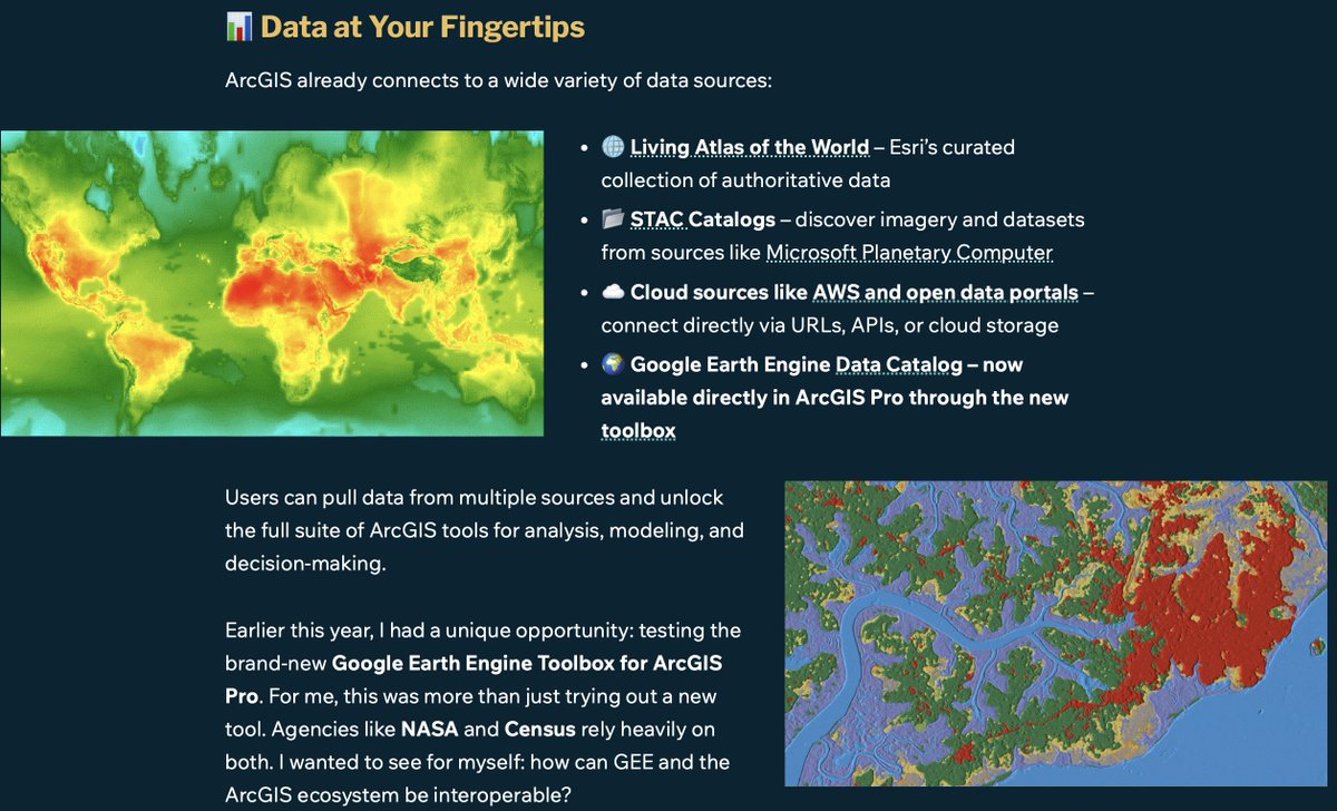
Did you know that you can now bring Google Earth Engine data right into ArcGIS Pro? Here’s a new storymap with details and a link to the tool on @github and thoughts on the new interoperability of GEE and @ArcGISPro storymaps.arcgis.com/stories/bf22d2… #gischat

Great new article! @IrekponorVictor and @TaylorOshan address reproducibility in spatially varying coefficient (SVC) models, and introduce svc-viz, a open source Python tool to-do this #GISchat doi.org/10.1080/152304… github.com/marquisvictor/…


Aus Soar.Earth wird SoarAtlas.com / becomes geoobserver.de/2025/10/09/aus… via @SoarAtlas #soar #gistribe #gischat #fossgis #foss4g #OSGeo #spatial #geospatial #DataViz #gis #geo #geoObserver pls RT


Cool job in SC! governmentjobs.com/careers/sc/job… #EMGTwitter #GISChat
🎥 Tutorial Demonstration Creating a Bivariate Map 🗺️ of Saudi Arabia 🇸🇦 combining Temperature 🌡️ and Precipitation 🌧️ Chelsa data using a custom Processing Script in QGIS 🟢. credit @milosmakesmaps and thanks to @LucasBlachet (idea) #SaudiArabia #qgis #gischat #Python


ESRI-Shape-File: Typische Fehler im Handling (Update) / Common handling errors (update) geoobserver.de/2025/10/02/esr… #shape #gistribe #gischat #fossgis #foss4g #OSGeo #spatial #geospatial #gis #geo #geoObserver pls RT

Tutorial Demonstration Using (New) Terra Climate Downloader QGIS Plugin to fetch 🌡️ Saudi Arabia’s🇸🇦 2024 Maximum Temperature data in just a few clicks🗺️ Empowering climate analysis made simple. #SaudiArabia #QGIS #GISChat #ClimateData #TerraClimate #Geospatial #RemoteSensing
Great new article from Michala A. Garrison, Schyler A. Reis, Shiyu Zhang and Carolyn S. Fish, evaluating “narrative transportation” – how engrossed one becomes in a story when used in storytelling maps, and the impact of including maps and photos doi.org/10.1080/152304… #GISchat

New paper from Yunfei Ma, Yuan Zhang and colleagues, Where is Huaqiangbei? looking at how Huaqiangbei, one of Shenzhen’s largest business districts, has evolved over time doi.org/10.1080/152304… #GISchat


🗺️ Making maps with R 🗺️ Examples of static and interactive maps and mobility flows using {ggplot2}, {leaflet}, {mapview}, {tmap} & {flowmapblue} 👉 paulamoraga.com/book-spatial/m… #rstats #rspatial #GISchat #datascience
Want to learn how to analyze and visualize spatial data in the social sciences? I'm now offering my Introduction to Spatial Data and R as a GIS course on #InStats in March 2025, instats.org/seminar/introd…, more courses and info at nickbearman.com/training-cours… #GISchat


Back in my student days, the urban design class taught a trick of adding “fake shadows” into maps quickly in Photoshop by: 1. Duplicate the building polygons 2. Offset it by a tiny distance 3. Change it to black & put it behind Same technique can be used in QGIS too #gischat


I’ve created a Russian-language “Soviet atlas”-style map of Middle-earth. You can download it for free in high resolution: disk.yandex.ru/d/R8YXcS9WPtVC… #gischat
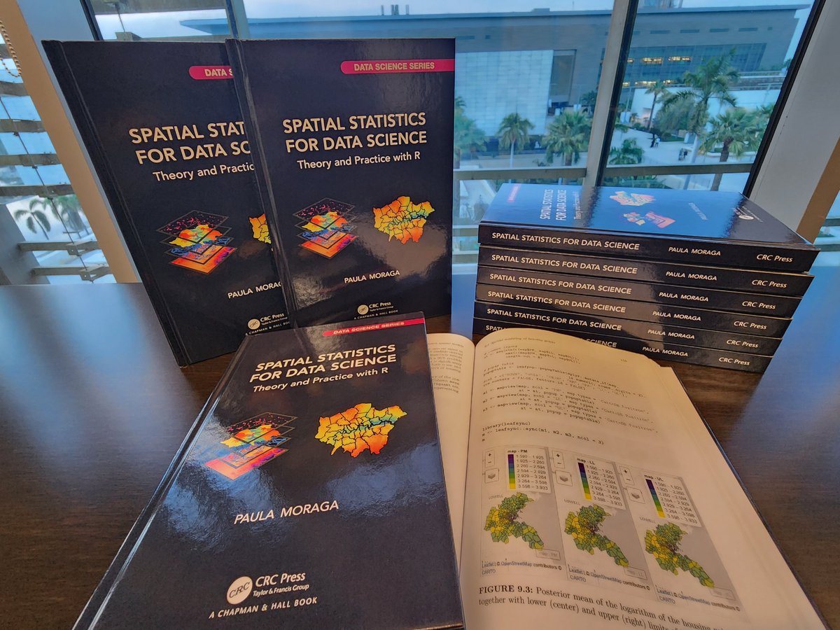
I just received the hardcopies of my book ✨ Spatial Statistics for Data Science ✨ 👉 paulamoraga.com/book-spatial/ Many thanks @CRC_MathStats! They look great! 🤩 💻#rstats 🗺️#rspatial ⚡️#gischat 📊#RINLA 📈#datascience 🌍#dataviz 🌈#epitwitter 🌿#ecology 📕 #statistics
I am looking for the best open-source algorithm for converting a building raster to vector without oversimplifying the outlines, something better than the minimum rotated rectangle algorithm. Let me know if you have any recommendations. Thanks. #geospatial #gischat #building…
Spatial prediction methods for geostatistical data such as disease prevalence 🪰, precipitation 🌧️, contaminants 🏭, household prices 🏡 🔗paulamoraga.com/book-spatial/s… #rstats #rspatial #GISChat
Hooray! In one of the best feel-good stories of the year, the little puppy who wandered onto the Esri campus lost and scared, and cared for by Esri employees over several weeks, has now been officially adopted BY an Esri employee and given the name “LILO”!!!🥰 #GISchat
Incredible what you can find if you zoom in far enough on that Walz viral pic. Don't tell @John_M_Nelson #gischat


Working on slides for Intro to Spatial Data and R as a GIS course on #InStats, inc. classification & why it's important, which gives me the chance to show this great graphic from James Cheshire @spatialanalysis theconversation.com/next-slide-ple…, details at instats.org/seminar/introd… #GISchat
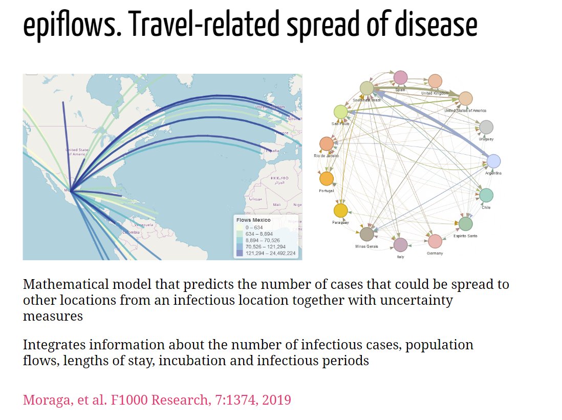
Muchisimas gracias @Rdaycolombia por la invitacion y las preguntas tan interesantes! 🇨🇴👩💻📊 Mi presentacion con recursos y ejemplos de #rstats para analisis de datos espaciales y la vigilancia en salud: 🔗 paulamoraga.com/presentation-g… #rspatial #GISchat #epitwitter


Average horizon distance in Whitebox Workflows Pro (WbW-Pro). #GIS #gischat #geospatial #geopython #DataVisualization

Last chance! Want to learn how to analyze and visualize spatial data in the social sciences? I'm now offering my Introduction to Spatial Data and R as a GIS course on #InStats on 4th & 5th March 2025, next week! instats.org/seminar/introd… #GISchat


Something went wrong.
Something went wrong.
United States Trends
- 1. Good Sunday 58.7K posts
- 2. Troy Franklin N/A
- 3. #sundayvibes 5,401 posts
- 4. Brownlee N/A
- 5. #AskFFT N/A
- 6. #AskBetr N/A
- 7. Rich Eisen N/A
- 8. Pat Bryant N/A
- 9. Muhammad Qasim 18.5K posts
- 10. Mason Taylor N/A
- 11. #DENvsNYJ N/A
- 12. #NationalFarmersDay N/A
- 13. Miary Zo 2,080 posts
- 14. Jermaine Johnson N/A
- 15. Discussing Web3 N/A
- 16. KenPom N/A
- 17. Wordle 1,576 X N/A
- 18. Trump's FBI 14.5K posts
- 19. The CDC 33.2K posts
- 20. Biden FBI 22.1K posts