#arcgis search results

Developing an interactive globe with the #ArcGIS #Maps #SDK for #JavaScript for my new personal website. Users can explore my projects by navigating the globe via the gallery thumbnails. Next up: linking each view to its project page and building the responsive mode.

🌿🌍 Mañana empieza el #curso que formará a los alumnos en el manejo de ArcGIS para la elaboración de estudios medioambientales. 🔗 bit.ly/Curso_ArcGIS_MA 💻 Online 📅 11 de noviembre 🕘 140 h ✅ Descuentos ℹ bit.ly/Form_ArcGIS_MA #SIG #ArcGIS #MedioAmbiente #EIA #ArcMap


استلمت كتاب #Enterprise #ArcGIS تعتبر نظم المعلومات الجغرافية المؤسسية نظام ضروري للمؤسسات التي تسعى لتعزيز الفعالية وتحقيق أهدافها الاستراتيجية من خلال الاستفادة من البيانات الجيومكانية حيث يلعب دور في: توحيد البيانات واستدامتها التكامل مع نظم أخرى حوكمة البيانات الجيومكانية


Bring GIS into #Civil3D workflows with #ArcGIS for #AutoCAD. Discover this tutorial series to learn how to get started adding coordinate systems, COGO points, TIN surfaces, and more. 🧠 Explore the tutorial series ➡️ ow.ly/LKcb50X6onX #AEC #Autodesk #engineering


✨The Life of a GIS Expert✨ If you have 3-6 months of ArcGIS experience, your next step should be to earn this technical certification! 🌎Learn more: ow.ly/qHFz50X5cY8 #GIS #ArcGIS


How to make a map layout using ArcMap? Map created using ArcGIS. Tutorial Link: youtu.be/gGdJzmyGasE For more information about registration, visit our website: studyhacksgeospatial.com/google-earth-e… #ArcMap #ArcGIS #MapLayout #GIS #Geospatial #Cartography #Mapping #DataVisualization

🧵 Lyon en point de croix 🌍 #30DayMapChallenge – Jour 9 : Analog écouvrez comment créer une carte brodée point par point avec ArcGIS Pro ! Inspirez-vous de la technique de John Nelson 👉 eu1.hubs.ly/H0psML90 #EsriFrance #ArcGIS #SIG


#ArcGIS Aviation Airports now supports ICAO’s updated Obstacle Limitation Surfaces (OLS) framework, improving #aviationsafety, compliance, and airport planning. Visualize and analyze airspace constraints more precisely and efficiently. Learn more: ow.ly/mZza50XmfRC


Desde @OIMSV, con el generoso apoyo de la Embajada de la República de Corea 🇰🇷, entregamos licencias del software #ArcGIS y 700 kits de asistencia humanitaria a @PROCIVILSV, fortaleciendo la coordinación y respuesta ante emergencias con un enfoque humano y basado en evidencia.


🏙️ Create a #DigitalTwin in just 7 days with #ArcGIS! Explore the step‑by‑step guide, tools, and tips to bring your real‑world to life virtually. #GIS Read to learn more ➡️ ow.ly/XS4a50X9XmN


Trippy terrain of Lielais Liepukalns and Dzierkaļu kalns (289 and 286 m a.s.l.) in Latvia, made with ArcGIS Pro. Day 5, Earth #30DayMapChallenge #dataviz #arcgis #map #esri


🚀 Version 4.34 of #ArcGIS Maps SDK for #JavaScript is here! Explore 3D flow rendering for animating directional raster data, split & merge features with Editor, slots for placing UI elements, & ground surface volume measurement in 3D! Learn more: ow.ly/RnE350XfNiX

¿Quieres ser parte del Mapa Global de Profesionales en SIG? es totalmente gratis y lo puedes hacer desde acolita.com/directorio #QGIS #ArcGIS

Join a free Esri training seminar on December 4 to learn about #ArcGIS for #Microsoft Fabric integrations and common use cases for analytical workflows. 🚀 Mark your calendar👇 ow.ly/QvCV50Xkz9Y


¡Brutales los avances en #GeoAI que trae #ArcGIS Pro y que nos han enseñado Celia y Libertad en la #CEsri25! 🤩🌍👏🏼 @Esri_Spain @ArcGISPro


Ever wonder how to turn geographic data into eye-catching graphics? Graphic Designer, Derick Mendoza, shows how with #ArcGIS Maps for Adobe Creative Cloud. From map creation to poster design—check out his tips in this step-by-step guide: ow.ly/u5T050XaPBH #MapsforAdobe


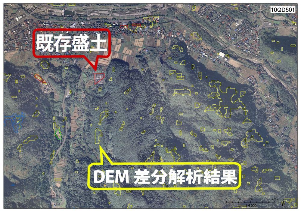
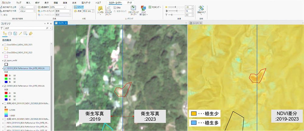
【事例】日本工営株式会社様 #ArcGIS で盛土規制法対応を実現! 🌍 ArcGISを活用し、盛土等の抽出と規制区域の指定を効率化。災害防止に向けた取り組みが進化しています。 詳細はこちら buff.ly/6AFHZvg #盛土規制法
Save time and reduce rework with #AutoCAD, #Civil3D, and ArcGIS all in sync. Download #ArcGIS for AutoCAD to enable seamless #GIS and #CAD collaboration by bringing ArcGIS to #Autodesk design environments. Download and learn more here ➡️ ow.ly/vLXi50WGksl


🌐 Thank you #INTERGEO2025 for hosting an incredible geospatial conference and trade show in Frankfurt, Germany 🇩🇪! Our @Esri teams were honored to be featured as keynote speakers at the event! Achieve resilient outcomes with AI-driven imagery and reality mapping in #ArcGIS


🌿🌍 Mañana empieza el #curso que formará a los alumnos en el manejo de ArcGIS para la elaboración de estudios medioambientales. 🔗 bit.ly/Curso_ArcGIS_MA 💻 Online 📅 11 de noviembre 🕘 140 h ✅ Descuentos ℹ bit.ly/Form_ArcGIS_MA #SIG #ArcGIS #MedioAmbiente #EIA #ArcMap

🚀 New blog post: Dive into building routing features with the ArcGIS Runtime SDK for Qt — click for code, routing and real‑world use cases 👉 manyatechnologies.com/arcgis-map-sdk… #GIS #ArcGIS #Qt #Routing #Navigation #FleetManagement #TrafficRouting #ManyaTechnologies


🚀 Master the Esri ESDP_2025 Exam & elevate your GIS career! Learn how to design scalable & secure ArcGIS Enterprise systems 🔍 🎥 Watch now: youtu.be/9glawq2NU4o #Esri #ArcGIS #DesignProfessional

youtube.com
YouTube
Ready to Ace the Esri ESDP_2025 Exam?

In the mining industry, timely access to accurate spatial imagery is crucial for effective site planning, environmental monitoring, and operational decision-making. 🔗 Read the full case study: hubs.ly/Q03QmkCQ0 #mining #ArcGIS


Curious about how AI assistants across #ArcGIS can boost productivity? Check out our blog to discover how these AI tools can help you map, code, and translate. ow.ly/q5iW50Xm6Qv

🧵 Lyon en point de croix 🌍 #30DayMapChallenge – Jour 9 : Analog écouvrez comment créer une carte brodée point par point avec ArcGIS Pro ! Inspirez-vous de la technique de John Nelson 👉 eu1.hubs.ly/H0psML90 #EsriFrance #ArcGIS #SIG
Teaching #ArcGIS? Researching with it? AI assistants are now woven across the ArcGIS platform and they're built to help. Join us to explore where, how, and why to use AI assistants in educational & research settings. Date: 11/4/2025 - 9 am PT | 12 pm ET ow.ly/u5fg50Xm6IH


Learn about a GCS deployment of an #Esri #ArcGIS Fire Hydrant Inspection Solution and what benefits the solution provide by clicking the link below: ow.ly/X3FM50Jpa2w #GIS #ArcGISOnline #ArcGISEnterprise

This just in! 📣 Using #ArcGIS #FieldMaps, capturing measurements along linear assets like roads🛣️, railways🚋, or pipelines just got easier! Learn how this supports inspection tasks to ensure construction projects are built according to design. #AEC ow.ly/Ve4B50Xos9S

Companies looking to manage forestry operations in the field, integrate with #MicrosoftDynamics365, and streamline processes can utilize the GeoBusiness Field Service Operations workflow for Forest Management. gcs.yourdatasmarter.com/forest-managem… #Esri #ArcGIS #GIS #MicrosoftD365 #D365


Discover what's new in the latest release of #ArcGIS for #AutoCAD. Enhance your civil design decisions, improve collaboration with the field, and customize. #Autodesk #Civil3D #CAD #GIS Read the blog to learn more ➡️ ow.ly/kh9R30sR5pv

Unlock the power of location analytics! Discover how #ArcGIS for Microsoft Fabric can help you analyze complex spatial data, visualize critical relationships, and drive informed decision-making. Read the full blog to learn more! ow.ly/CS9b50Xnt5a

Delivering #ArcGIS capabilities that support key business requirements, goals, and initiatives helps you improve business outcomes integrated with #ERP, #Financials, #CRM, #Ecommerce, & more. #Esri #EsriArcGIS gcs.yourdatasmarter.com/a-business-fir…

A visually appealing map can enhance your dashboard’s effectiveness. When done thoughtfully, themes allow you to achieve both a beautiful design and a functional dashboard that communicates critical information. ow.ly/WMbM50Xos8h #ArcGIS


📰 #ArcGIS Blog: Unlock your inner storyteller esri.com/arcgis-blog/pr… _ #Esri #GIS #Geospatial #MetaMapping
esri.com
Unlock your inner storyteller
Find answers to questions like "what's a story?" "how do I tell a story?" and "how do I share my place-based project story?"
Find out how GCS Cloud Architects can develop your organization's #ArcGIS cloud computing strategies. #Esri #Microsoft #Azure ow.ly/sgKi50Ho4S7

استلمت كتاب #Enterprise #ArcGIS تعتبر نظم المعلومات الجغرافية المؤسسية نظام ضروري للمؤسسات التي تسعى لتعزيز الفعالية وتحقيق أهدافها الاستراتيجية من خلال الاستفادة من البيانات الجيومكانية حيث يلعب دور في: توحيد البيانات واستدامتها التكامل مع نظم أخرى حوكمة البيانات الجيومكانية
Throughout history, the significance of land records information within local government operations has been underestimated and underutilized. #ArcGIS offers a comprehensive suite of data management tools. #GIS #Esri #Localgovernment gcs.yourdatasmarter.com/managing-local…

Securing your organization's campus and facilities cannot be accomplished without understanding the operational environment. GeoBusiness provides indoor mapping for #publicsafety and security operations with #ArcGISIndoors #ArcGIS #GIS #ESRI gcs.yourdatasmarter.com/geobusiness-pr…


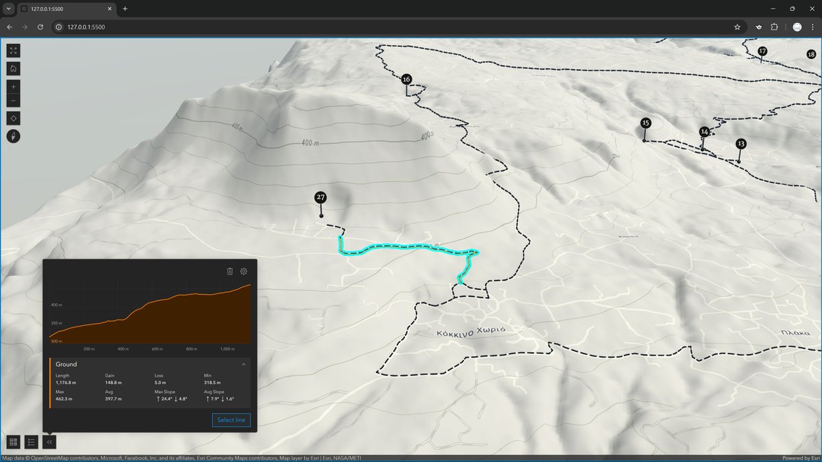
Here I leverage the #3D capabilities of the scene view in #ArcGIS #SDK for #JavaScript to create a dynamic #Elevation profile widget that adapts to each selected trail. Trail metrics calculated on-the-fly. Commissioned project, work in progress; coming online soon!
Bring GIS into #Civil3D workflows with #ArcGIS for #AutoCAD. Discover this tutorial series to learn how to get started adding coordinate systems, COGO points, TIN surfaces, and more. 🧠 Explore the tutorial series ➡️ ow.ly/LKcb50X6onX #AEC #Autodesk #engineering
استلمت كتاب #Enterprise #ArcGIS تعتبر نظم المعلومات الجغرافية المؤسسية نظام ضروري للمؤسسات التي تسعى لتعزيز الفعالية وتحقيق أهدافها الاستراتيجية من خلال الاستفادة من البيانات الجيومكانية حيث يلعب دور في: توحيد البيانات واستدامتها التكامل مع نظم أخرى حوكمة البيانات الجيومكانية
✨The Life of a GIS Expert✨ If you have 3-6 months of ArcGIS experience, your next step should be to earn this technical certification! 🌎Learn more: ow.ly/qHFz50X5cY8 #GIS #ArcGIS
🌿🌍 Mañana empieza el #curso que formará a los alumnos en el manejo de ArcGIS para la elaboración de estudios medioambientales. 🔗 bit.ly/Curso_ArcGIS_MA 💻 Online 📅 11 de noviembre 🕘 140 h ✅ Descuentos ℹ bit.ly/Form_ArcGIS_MA #SIG #ArcGIS #MedioAmbiente #EIA #ArcMap
In a world of AI, IoT, and real-time data, quality matters more than ever. #ArcGIS Data Reviewer, an extension for #ArcGISPro, helps you manage and maintain high-quality geospatial data. See why data quality matters: ow.ly/I7fz50WU4uI

🧵 Lyon en point de croix 🌍 #30DayMapChallenge – Jour 9 : Analog écouvrez comment créer une carte brodée point par point avec ArcGIS Pro ! Inspirez-vous de la technique de John Nelson 👉 eu1.hubs.ly/H0psML90 #EsriFrance #ArcGIS #SIG
How to make a map layout using ArcMap? Map created using ArcGIS. Tutorial Link: youtu.be/gGdJzmyGasE For more information about registration, visit our website: studyhacksgeospatial.com/google-earth-e… #ArcMap #ArcGIS #MapLayout #GIS #Geospatial #Cartography #Mapping #DataVisualization
🏙️ Create a #DigitalTwin in just 7 days with #ArcGIS! Explore the step‑by‑step guide, tools, and tips to bring your real‑world to life virtually. #GIS Read to learn more ➡️ ow.ly/XS4a50X9XmN


🦈ProtectedSeas, a pioneering project committed to mapping and sharing global ocean protection data, is now part of #ArcGIS Living Atlas of the World! 🌊Access and explore it in #ArcGISPro today. Learn more: ow.ly/6aHc50WVtN3

Desde @OIMSV, con el generoso apoyo de la Embajada de la República de Corea 🇰🇷, entregamos licencias del software #ArcGIS y 700 kits de asistencia humanitaria a @PROCIVILSV, fortaleciendo la coordinación y respuesta ante emergencias con un enfoque humano y basado en evidencia.
Ever wonder how to turn geographic data into eye-catching graphics? Graphic Designer, Derick Mendoza, shows how with #ArcGIS Maps for Adobe Creative Cloud. From map creation to poster design—check out his tips in this step-by-step guide: ow.ly/u5T050XaPBH #MapsforAdobe

Managing multiple languages in #ArcGIS #Survey123 has never been better. 📝🦾Explore different options to support translations in your surveys including the Translation assistant: ow.ly/tRzN50WTx0p

XLSForm is a standard format for designing forms in Microsoft Excel. Learn more about creating surveys in #ArcGIS #Survey123 using XLSForm for defining questions, choices, and logic in a spreadsheet. 📝📒 ow.ly/y9A950X7hLx


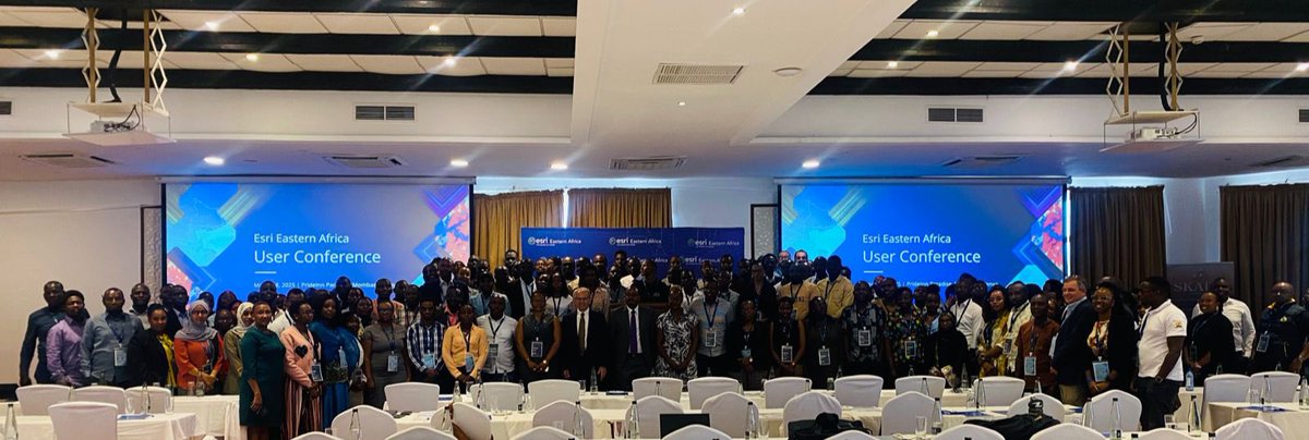
Attended the Esri Eastern Africa User Conference in Mombasa🌍📍 Explored cutting edge Esri software innovations, shared Kampala Capital City’s GIS experience, and joined a dynamic panel discussion. Incredible learning & networking opportunities! #EsriEAUC #GIS #ArcGIS #Innovation


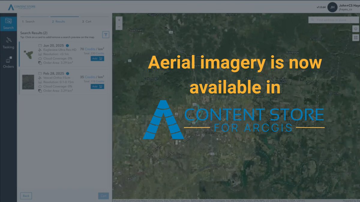
High-res aerial imagery is now available directly in SkyWatch’s Content Store for @Esri ArcGIS! Access premium data, preview & purchase it right inside your Esri environment. Learn more 👇 hubs.li/Q03PTCyK0 #GIS #ArcGIS #AerialImagery #EarthObservation
【事例】日本工営株式会社様 #ArcGIS で盛土規制法対応を実現! 🌍 ArcGISを活用し、盛土等の抽出と規制区域の指定を効率化。災害防止に向けた取り組みが進化しています。 詳細はこちら buff.ly/6AFHZvg #盛土規制法
ArcPyを調べるのに役立つリファレンスページの見方について解説しています。 特に入門者~初級者にお勧めの内容となっています。 |Esri Community Blog|[ community.esri.com/t5/a/a/ta-p/16… ] #ArcGIS #地図 #開発 #arcpy
![ESRIJapan's tweet image. ArcPyを調べるのに役立つリファレンスページの見方について解説しています。
特に入門者~初級者にお勧めの内容となっています。
|Esri Community Blog|[ community.esri.com/t5/a/a/ta-p/16… ]
#ArcGIS #地図 #開発 #arcpy](https://pbs.twimg.com/media/G0ns715aAAAxNkG.jpg)
![ESRIJapan's tweet image. ArcPyを調べるのに役立つリファレンスページの見方について解説しています。
特に入門者~初級者にお勧めの内容となっています。
|Esri Community Blog|[ community.esri.com/t5/a/a/ta-p/16… ]
#ArcGIS #地図 #開発 #arcpy](https://pbs.twimg.com/media/G0ntU-uaMAA4MDx.png)
![ESRIJapan's tweet image. ArcPyを調べるのに役立つリファレンスページの見方について解説しています。
特に入門者~初級者にお勧めの内容となっています。
|Esri Community Blog|[ community.esri.com/t5/a/a/ta-p/16… ]
#ArcGIS #地図 #開発 #arcpy](https://pbs.twimg.com/media/G0ntYE0aYAAZnWK.jpg)

What a spark of genius from @NIElectricity! The organisation has completely automated a critical health and safety process with #ArcGIS, saving time and money and improving sustainability #GIS #EsriIreland #Utilities #Health&Safety ow.ly/pef350WP9WE

Something went wrong.
Something went wrong.
United States Trends
- 1. Steelers 52.8K posts
- 2. Rodgers 21.3K posts
- 3. Chargers 38K posts
- 4. Tomlin 8,348 posts
- 5. Resign 109K posts
- 6. Schumer 228K posts
- 7. Mr. 4 4,825 posts
- 8. Tim Kaine 20.7K posts
- 9. Sonix 1,169 posts
- 10. #BoltUp 3,066 posts
- 11. Dick Durbin 13.4K posts
- 12. 8 Democrats 9,644 posts
- 13. Angus King 17.3K posts
- 14. #ITWelcomeToDerry 4,860 posts
- 15. Rudy Giuliani 10.3K posts
- 16. Keenan Allen 5,052 posts
- 17. #RHOP 7,072 posts
- 18. 8 Dems 7,521 posts
- 19. #HereWeGo 5,734 posts
- 20. Maggie Hassan 17.6K posts