#gisdata search results

What are the types of error found in GIS data? This article reviews the difference between accuracy and precision and explains the most common types of error found in GIS data.#errortypes #gisdata buff.ly/3u35hhY


Are you wasting hours searching for #GISdata across multiple platforms? ⌛️ Are you spending time searching, instead of analyzing and decision-making?


Did you know @LightBoxRE has zoning data for the top 50 MSAs nationally? Gain a better understanding of zoning setbacks, lot area, density, and other attributes for a property. Learn more: bit.ly/3SPhFuo #LightBoxRE #Zoning #GISData #CRE

Huge thanks to all SEC participants for joining our #urscape #GISdata workshop by Agropolitan Territories of Monsoon Asia (#AGR)! Held today at Value Lab Asia, we explored #dataintegration techniques, enriching our understanding of #urscape's capabilities for #research. 👩💻


Are you attending #Geopalooza 4.0 in Nairobi, Kenya this year? Join tomorrow for our breakout session: ‘Mapping up the entire DRC’, and hear from our DRC National Coordinator, Emmanuel Rukengwa, on our progress to fill gaps in #GISdata in DRC.


Day 1 of the #30DayMapChallenge calls for points showing tram stops in @Melbourne - Australia. Did you know Melbourne has the largest tram network in the world? pretty impressive huh! 🚋 #gisdata Data from: VIC Gov


Today, we're proud to announce a partnership with @DATAMARKGIS to help public safety agencies realize the full potential for their GIS mapping data to plan, prepare and respond to emergency incidents. Read more: bit.ly/46JMciW #publicsafety #gismapping #gisdata

Trust #DroneAcharya for turnkey drone solutions! Our DGCA certified pilots and GIS Data Experts deliver high-quality data for various industries. Get insightful, project-specific outcomes. Contact us today to learn more! 🌐📞 #Drones #GISData #CertifiedPilots


Check out the latest NOAA datasets! coast.noaa.gov/dataviewer/#/l… coast.noaa.gov/digitalcoast/d… storymaps.arcgis.com/stories/f22c0f… #higicc #gisdata #noaa


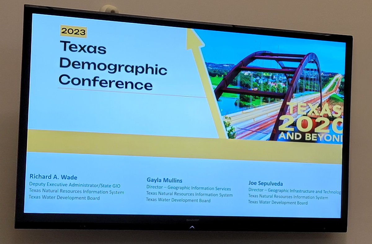
This week we enjoyed wonderful data-centric content at the 2023 TX Demographic Conference, and our very own Richard Wade, Gayla Mullins, & Joe Sepulveda presented on @TNRIS’ services and data offerings. Thank you @TexasDemography for a great event! #txgis #gisdata #opendata


Happy Cuba National Day and cheers to its natural charm and beauty! 🇨🇺 Let’s enjoy the breathtaking blue waters of Cuba, as we look forward to the upcoming summer days. 🌞 Enjoy this image of the country from our PlanetSAT 10m #SatelliteImagery Basemap. #GeospatialData #GISData


Easier, faster, better—that’s the promise of Esri’s new focused app for data editing, ArcGIS Web Editor. #ArcGISWebEditor #GISdata esri.social/SXY850Sqm3w


Latest news: Bluesky named sole supplier of national aerial photography to UK Government #aerialsurvey #mapping #gisdata #geospatial Read the full story: Bluesky Named Sole Supplier of Aerial Photography to UK Government (bluesky-world.com)

Like Stephen F. Austin, who ensured all land parcels of his grant that settled 300 families in Tejas, MX in 1823 was surveyed, @TNRIS is following suit. Land Parcels/Address Pts data collection is underway w/expected ETA Summer 2023. Visit data.tnris.org. #gisdata #txgis


A Man, A Plan, A Canal…. How It All Went Wrong Without #DataGovernance ow.ly/iBZA50PNxVw #gisdata #geospatialdata


🌍 Explore how GIS data is reshaping urban spaces for a smarter, more sustainable future! From parks to transportation, unleash the power of data-driven decisions. Discover more in our latest blog! #GISData #UrbanInfrastructure🏙️🌿📊bit.ly/3OMHVnt

When you need #geospatialdata for a #classroomproject or personal project, we've got you covered! directionsmag.com/data-resources #gisdata #datasources #geography #k12

🚀 We're heading out for Denver, next stop @GeoWeekExpo! Stop by Booth 226 to discover how Fulcrum is revolutionizing GIS-first data collection. 🌍 🤝Looking forward to connecting and exploring geospatial innovation together. #GeoWeek #GISData geo-week.com


Relying on zip codes for sales tax is a gamble. ✅ GIS rooftop accuracy = precise situsing ✅ Better compliance, fewer audits ✅ No more costly errors See why location accuracy is the compliance advantage: 👉 hubs.ly/Q03GK7ts0 #SalesTax #LocationAccuracy #GISData


Who needs this map? • Urban planners • Real estate developers • Government agencies • Agricultural investors • Emergency response teams • Researchers & educators Get accurate coordinates: 7°00′N-9°12′N, 2°45′E-4°30′E #LandSurvey #NigeriaMaps #GISData | Japan | Ghe Ghe


How to Increase the Accuracy of GIS Data Insights? #GIS #GISdata #GISinsights #GISservices #LiDAR #Geospatial @LandSurveyorsU blog.polosoftech.com/how-to-increas…


🏚️ Catastrophe models crumble under inconsistent address data. If “123 Main St.” ≠ “123 Main Street,” your storm risk model is toast. Garbage in → chaos out. #CatModeling #PropertyInsurance #GISdata
Photos. Video. GIS. Every answer, ready when it’s needed. DIEHLUX, LLC doesn't just document. It delivers. 🎯 Want to see how? Book your custom Fulcrum demo today to get started. 👉 tinyurl.com/yc3znxxd #GIS #FieldData #GISData #FieldTech


🚀 Quick QGIS Hack: Klik kanan layer → Export → Save Features As untuk ubah shapefile ke GeoJSON, KML, CSV, GPKG, dan lainnya. QGIS dukung banyak format! #GISData #QGISPower #zonauang
📊 Four real-world field teams, one platform. From urgent transformer leaks to consolidated wellhead inspections, Fulcrum GIS-rich field data platform automates workflows that used to take days. 👉 tinyurl.com/4r27252j #GISData #FieldAutomation #FieldOps

Field crews don’t speak in points — they work in shapes. Lines mark the sag. Polygons show the overgrowth. And Fulcrum turns all of it into action. 👉 tinyurl.com/bdwhx2m6 #FieldData #GIS #GISData


Assistant GIS Data Officer (Paths) for @nationaltrust based in Manchester city centre See: ow.ly/qXeh50VoHOj #ManchesterJobs #NationalTrust #GISData

GIS Data Conversion Process - A Guide for 2025 blog.polosoftech.com/gis-data-conve… #GIS #GISdata #GISdataconversion #GISmapping @LandSurveyorsU @EsriTraining @CanadianGIS @geospatialworld
blog.polosoftech.com
GIS Data Conversion Process - A Guide for 2025
GIS data conversion is the process of transforming geographical data from one format to another.


LSIB 9 as open data! Amazing working with the @USDOS over the past ten years on this project... revolutionarygis.wordpress.com/2018/06/06/lsi… #opendata #gisdata #gis #cartography #bigdata #gistribe #maps #data @Mapbox @Esri

What are the types of error found in GIS data? This article reviews the difference between accuracy and precision and explains the most common types of error found in GIS data.#errortypes #gisdata buff.ly/3u35hhY

GIS Planning is proud to be an event partner for @edaalberta's Xperience 2021 virtual conference. #EcDev #siteselection #GISdata #WeAreWhatsNew


Ya está disponible para #descargar la versión 3 del Modelo Digital de Elevación (#MDE) de todo el planeta de ASTER ⛰️🗺️. by @GISLounge #gisdata #descarga #gis 🗞️ Noticia: gislounge.com/version-3-of-a…


💡 Would you like to acquire strong knowledge of what is #GIS? 💡 And find and manage vector and raster data? 💡 As well as process and analyse #GISdata using the most advanced programming techniques? Join next may this 5-days’ online course on GIS: ✍🏿 ow.ly/9mX150Dz2CD


Using data from SafeGraph I put together this map of POIs in the US that have the name Pumpkin. Want to learn how I did it? If you were to make a fall-themed map, what would you map? tabulaespatial.com/how-to-make-a-… #SafeGraph #GISData #GeospatialAnalysis

Huge thanks to all SEC participants for joining our #urscape #GISdata workshop by Agropolitan Territories of Monsoon Asia (#AGR)! Held today at Value Lab Asia, we explored #dataintegration techniques, enriching our understanding of #urscape's capabilities for #research. 👩💻
Day 1 of the #30DayMapChallenge calls for points showing tram stops in @Melbourne - Australia. Did you know Melbourne has the largest tram network in the world? pretty impressive huh! 🚋 #gisdata Data from: VIC Gov

GIS Planning is proud to be an event partner for @edaalberta's Xperience 2021 virtual conference. #EcDev #siteselection #GISdata #WeAreWhatsNew


Tempe’s leadership in public health innovation for wastewater epidemiology is being funded by the State of Arizona with a $1 million partnership to expand the city’s program, help develop best practices. mailchi.mp/tempe/tempe-wa… #gisdata #wastewaterscience #azdhs #cdc #covid19az

Tempe Accelerates will explore the data and progress being made regarding the City of Tempe's efforts on quality Pre-K enrollment and third grade reading level proficiency. Join in the conversation at 2 p.m. on Thursday. tempe.gov/TempeAccelerat… #tempeaz #GISdata #ourtempe

#AmericanWetlandsMonth @BLMAlaska partnered with @USFWSAlaska to help inventory an additional 17% of #wetlands for the U.S. Fish and Wildlife Service National Wetlands Inventory (NWI) Program. #GISData #Mapping Read: fws.gov/alaska/stories…


The #acclab in Tunisa in partnership with @AGEOS5 is empowering BeniKhalled with citizens and #GISdata to support decision making in #wastemanagement. Today we met to start learning collectively about the social and economic impact of this initiative with our partners.


A good reminder that at any given time, we are on indigenous land @ESIPfed #maps #GISdata territory acknowledgement


Exploring the toolbox for urban #resilience through #greeninfrastructure - #GISdata, cost-benefit analysis, community engagement, maintenance @NYCWater @ASLA_NY #risingurbanists


They’re here! We're happy to announce the statewide 2022 Land Parcel and Address Point Data are available for download through the TNRIS DataHub. Check it out here: data.tnris.org #txgis #gisdata #dataviz

Today's COVID-19 newsletter includes info about the National Month of Action, Tempe's new data dashboard, Pride Month, Cruise the Zoo and Chai Corner, as seen on "Restaurant Recovery." Shown: our COVID-19 testing crew mailchi.mp/tempe/june-2-2… #gisdata #ourtempe #phoenixpride

Something went wrong.
Something went wrong.
United States Trends
- 1. Broncos 32.8K posts
- 2. Raiders 42.7K posts
- 3. #911onABC 21.6K posts
- 4. Bo Nix 6,307 posts
- 5. AJ Cole N/A
- 6. GTA 6 82.3K posts
- 7. #WickedOneWonderfulNight 2,456 posts
- 8. eddie 42.9K posts
- 9. Geno 6,607 posts
- 10. Chip Kelly N/A
- 11. #TNFonPrime 2,580 posts
- 12. Crawshaw N/A
- 13. #RaiderNation 2,582 posts
- 14. tim minear 2,500 posts
- 15. Cynthia 35.2K posts
- 16. Ravi 15.2K posts
- 17. Jeanty 4,131 posts
- 18. Al Michaels N/A
- 19. #RHOC 1,890 posts
- 20. Mostert N/A