#mapprojections search results

#endMercator #WebMercator #MapProjections #MapProjection #mapprojectionsarehard #projectionsarehard #gischat #ProjectionWizard


Rebuilt the Arctic Fox journey in @ArcGISPro ahead of #EsriUC demos next week to explore the issue of #mapprojections. For this map, Polar Stereographic is tough to beat.


40 world map clementines in under 2 hrs. Shout out to my mom for being my back up cartographer. 🌎 🍊#mapprojections

ما الفرق بين #إسقاط_الخرائط #MapProjections وأنظمة #الإحداثيات #CoordinateSystems؟ #إسقاط_الخرائط عبارة عن طرق تستخدم لتحويل السطح الكروي للأرض إلى مستوى ثنائي الأبعاد من المعلوم أن شكل سطح الأرض منحني وعندما يتم تمثيله على خريطة مسطحه ستحدث بعض التشوهات لذلك فإن الغرض الأساسي…


They say travel expands your horizons … pleased to have encountered the rarely used Equal Caffeination Opera-Sanremo Projection at @Zibettoespresso, just blocks from Carnegie Hall. #creativeCarto #mapProjections


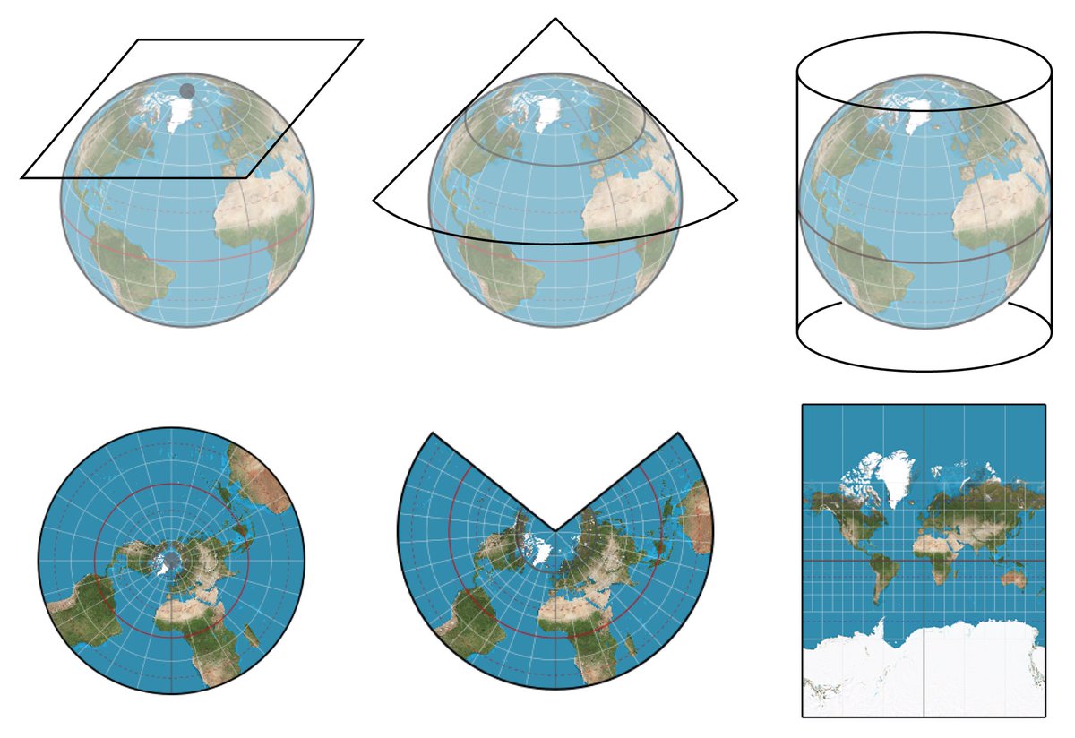
A map projection necessarily distorts *something* -- it is a 2-dimensional representation of a 3-dimensional reality. Different projections distort different things (& get other things right) 🌍📷-- en.wikipedia.org/wiki/List_of_m… -- #MercatorProjection #MapProjections #Cartography
We'll be talking #Lego and #mapprojections with our special guest @BojanSavric when we 'ask a cartographer' during today's ##EsriUC #MappyHour. Join us at 4pm PDT.


#30DayMapChallenge 🗺️ (Day 26: #MapProjections) Perth, Western Australia, is often referred to as the world's most isolated major city. This map visualises the international flights departing from Perth. This map uses an #AzimuthalEquidistantProjection with Perth as the origin.


Happy GIS Day! Here I am showing Jack Dangermond how I teach map projections with my illuminated globe... #MapProjections #GISDay

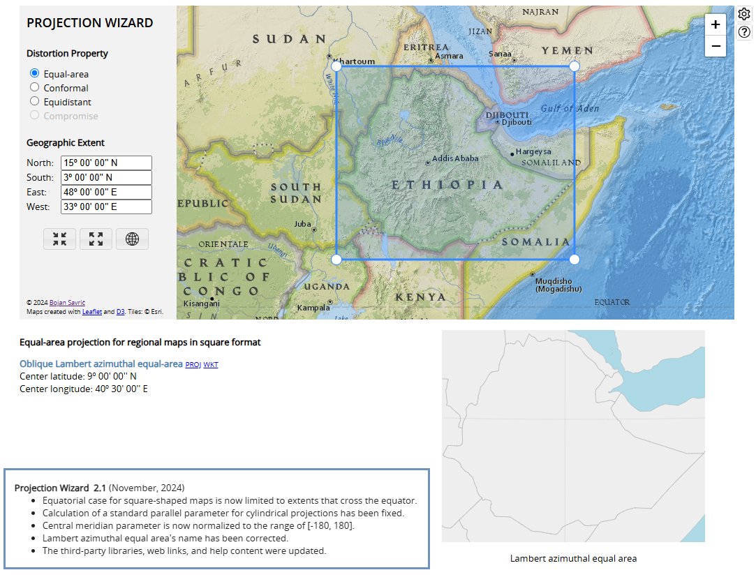
📣A new version of #ProjectionWizard v2.1 🗺️🌐🪄 is now live as of this morning. Visit projectionwizard.org #mapprojection #mapprojections #webMercator #endMercator #mapprojectionsarehard #projectionsarehard #gischat #geospatial
And today I learned about the 5 May 1953 Nancy projection. Envious that Nancy doesn't seem to have the orange peel problems everyone else runs into. #creativeCarto #mapProjections


I had the pleasure of giving a guest lecture to students in the @cartography_MSc program at TUM. Another group of future cartographers is now fully familiar with the concepts of #mapprojections, and they even gained experience in creating their own using the clementine technique.


STREEEETCH!!!!! What happens when you flatten a globe into a map??? Uh oh!!! I see distortions! Applying our spatial perspective skills! #MapProjections #LearnersToday #LeadersTomorrow @BrenhamHS


Everyone did well on yesterday's projection. Today's contribution from @harvartmuseums is a less standard projection though—Agnes Denes' Cube projection from 1986. #maps #mapprojections

#developers @Esri #DevSummit Would you like to use other #mapprojections for your web #map? Check out @EsriDevSummit on-demand session "Use Literally Anything but Web Mercator": dev2021.esri.com/live-stream/19… #endMercator #mapprojectionsarehard #WebMercator #mapprojection


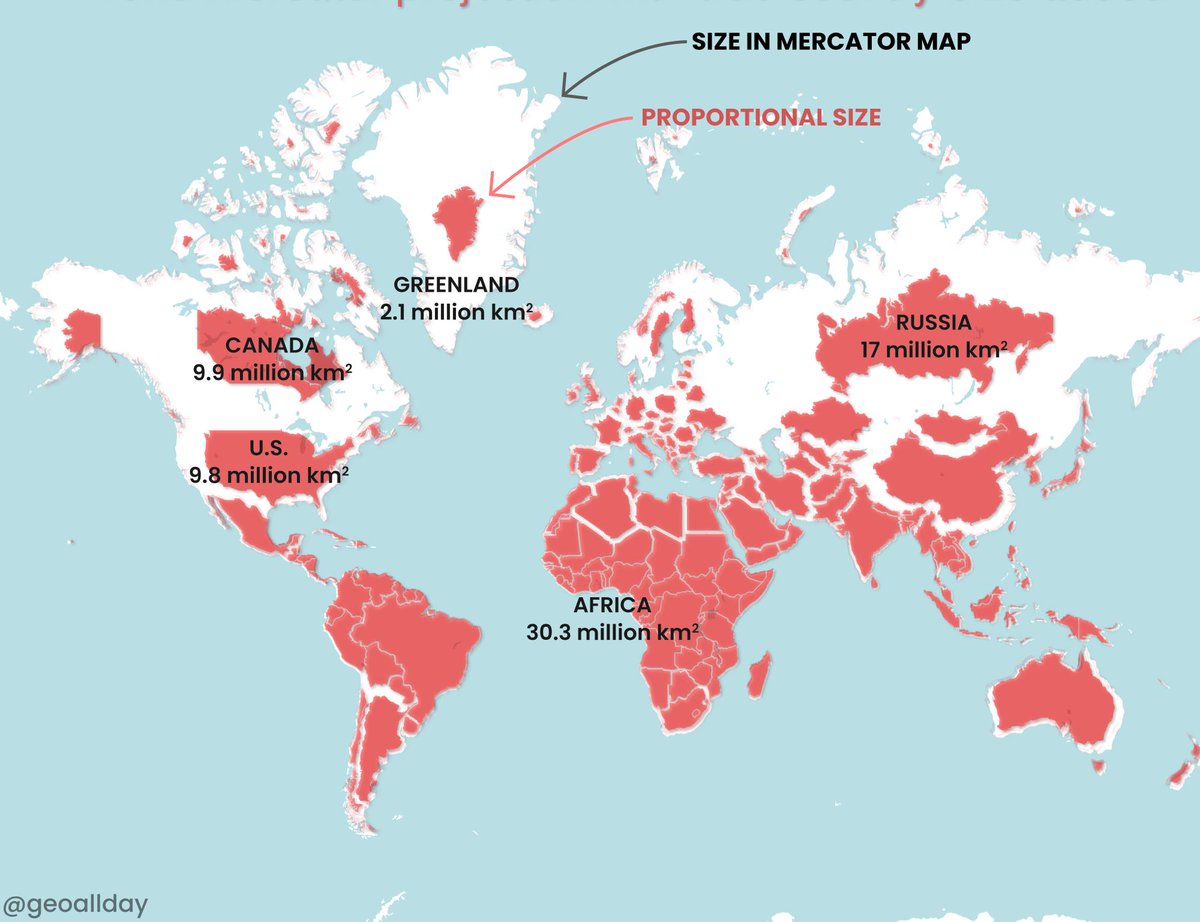
Saviez-vous que le Groënland est en réalité plus petit que l'Algérie ? #30DayMapChallenge - Jour 26 : #MapProjections Superficie de l'Algérie : 2 382 000 km² Superficie du Groënland : 2 166 000 km² Si vous êtes curieux, découvrez ce site : eu1.hubs.ly/H0dZpD-0 #ArcGIS #Maps


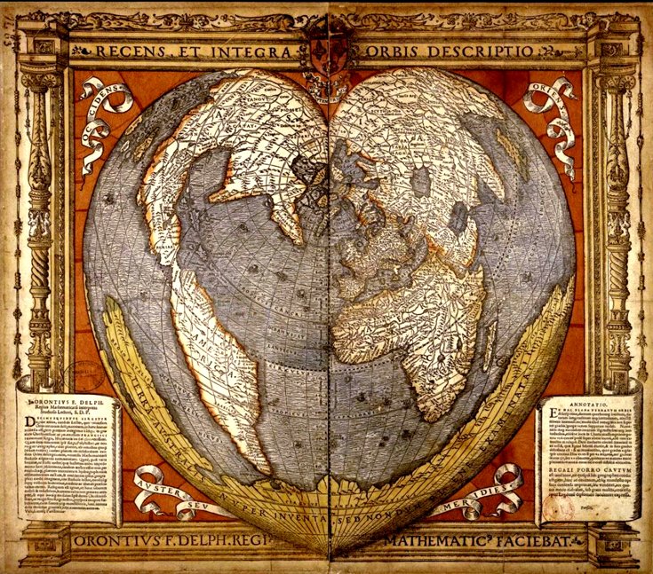
We couldn't let #ValentinesDay pass without showing some love for this 1536 cordiform (cor= heart in Latin) map of the world by the French mathematician & cartographer Oronce Fine. Distances are correct from 1 pole & also along all parallels & the central meridian #MapProjections

Today’s #30DayMapChallenge is all about projections. Here’s the world through a heart-shaped projection, giving the map a creative twist the farther out you look. #Cartography #MapProjections
A map projection necessarily distorts *something* -- it is a 2-dimensional representation of a 3-dimensional reality. Different projections distort different things (& get other things right) 🌍📷-- en.wikipedia.org/wiki/List_of_m… -- #MercatorProjection #MapProjections #Cartography

The Vastness of the Pacific Ocean Read more: linkedin.com/feed/update/ur… #GeoICT #PacificOcean #MapProjections #GIS ©️ Natural Earth


In 1569, Gerardus Mercator created a map projection that made navigation easier but distorted sizes. Greenland looks as big as Africa, but it's actually 14 times smaller! This "lie" influenced colonial views. #geographyteacher #geography #MapProjections #GeographyFacts #WorldMaps


Lapaine, M., Frančula, N., Viličić, M.: #MapProjections and Sustainability / Kartografske projekcije i održivost, Kartografija i geoinformacije 23, 2024, 41, 52-64, croris.hr/crosbi/publika…
I had the pleasure of giving a guest lecture to students in the @cartography_MSc program at TUM. Another group of future cartographers is now fully familiar with the concepts of #mapprojections, and they even gained experience in creating their own using the clementine technique.
Saviez-vous que le Groënland est en réalité plus petit que l'Algérie ? #30DayMapChallenge - Jour 26 : #MapProjections Superficie de l'Algérie : 2 382 000 km² Superficie du Groënland : 2 166 000 km² Si vous êtes curieux, découvrez ce site : eu1.hubs.ly/H0dZpD-0 #ArcGIS #Maps
#30DayMapChallenge 🗺️ (Day 26: #MapProjections) Perth, Western Australia, is often referred to as the world's most isolated major city. This map visualises the international flights departing from Perth. This map uses an #AzimuthalEquidistantProjection with Perth as the origin.

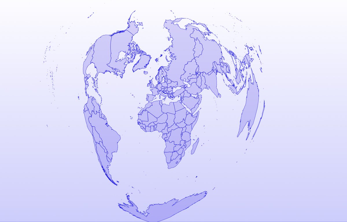
Day 26 of the #30DayMapChallenge: Exploring the world through different map projections! 🌍 Today, I'm highlighting the Bonne Projection, which gives a unique heart-shaped view of the globe 💙. A fun and striking way to see our planet! #MapProjections #DataViz @rnaturalearth

Day 26 of the #30DayMapChallenge! 🌍 Today’s theme: Map Projections. 🌐 This animation shows a few different ways to view the world, each distorting the globe in unique ways. I’m especially fond of the Bonne Projection, which looks like a heart! 💙 #MapProjections #GIS
It has been 10 years since #ProjectionWizard 🗺️🌐🪄 was first introduced at @NACIS Practical Cartography Day @nacis_PCD #nacis2014. To all of you, who are using the tool to select #mapprojections for your 🗺️map projects, a huge THANK YOU! 🙏🙏🙏 Happy #mapping!🌎🌍🌏
📣A new version of #ProjectionWizard v2.1 🗺️🌐🪄 is now live as of this morning. Visit projectionwizard.org #mapprojection #mapprojections #webMercator #endMercator #mapprojectionsarehard #projectionsarehard #gischat #geospatial

Understanding Map Projections: freecomputerbooks.com/Understanding-… A clear understanding of the processes necessary to make logical decisions on selecting an appropriate map projection for a given data set. #Cartography #MapProjections #gis #GeographicInformationSystems #GeospatialAnalysis


6.Light blue is a map as we know it and dark blue is the actual size of each country

Do you have any questions about #MapProjections, coordinate systems, and transformations still unanswered? Stop by for a chat at @ArcGISPro Coordinate Systems Expo kiosk. We are here until 4pm. 🌐 #EsriUC #EsriUC2024 @EsriUC storymaps.arcgis.com/stories/497360…

Day 3 of the @EsriUC #EsriUC #EsriUC2024. Do you have questions about #MapProjections, coordinate systems, and transformations? Stop by for a chat at @ArcGISPro Coordinate Systems Expo kiosk. We also know a thing or two about NSRS 2022 modernization. 🌐🗺️ storymaps.arcgis.com/stories/497360…

After great @EsriUC Plenary yesterday, it is time for @Esri Showcase Expo. If you have questions about coordinate systems, transformations, #MapProjections, #SpatialReference, look for #MapProjection Engine team at @ArcGISPro Coordinate Systems Expo kiosk. 🌐 #EsriUC #EsriUC2024

#endMercator #WebMercator #MapProjections #MapProjection #mapprojectionsarehard #projectionsarehard #gischat #ProjectionWizard
Today’s #30DayMapChallenge is all about projections. Here’s the world through a heart-shaped projection, giving the map a creative twist the farther out you look. #Cartography #MapProjections
The Vastness of the Pacific Ocean Read more: linkedin.com/feed/update/ur… #GeoICT #PacificOcean #MapProjections #GIS ©️ Natural Earth
40 world map clementines in under 2 hrs. Shout out to my mom for being my back up cartographer. 🌎 🍊#mapprojections
Convert a 3D cartesian map to Healpix projection stackoverflow.com/questions/6087… #astropy #healpy #mapprojections #astronomy

They say travel expands your horizons … pleased to have encountered the rarely used Equal Caffeination Opera-Sanremo Projection at @Zibettoespresso, just blocks from Carnegie Hall. #creativeCarto #mapProjections
📣A new version of #ProjectionWizard v2.1 🗺️🌐🪄 is now live as of this morning. Visit projectionwizard.org #mapprojection #mapprojections #webMercator #endMercator #mapprojectionsarehard #projectionsarehard #gischat #geospatial
ما الفرق بين #إسقاط_الخرائط #MapProjections وأنظمة #الإحداثيات #CoordinateSystems؟ #إسقاط_الخرائط عبارة عن طرق تستخدم لتحويل السطح الكروي للأرض إلى مستوى ثنائي الأبعاد من المعلوم أن شكل سطح الأرض منحني وعندما يتم تمثيله على خريطة مسطحه ستحدث بعض التشوهات لذلك فإن الغرض الأساسي…
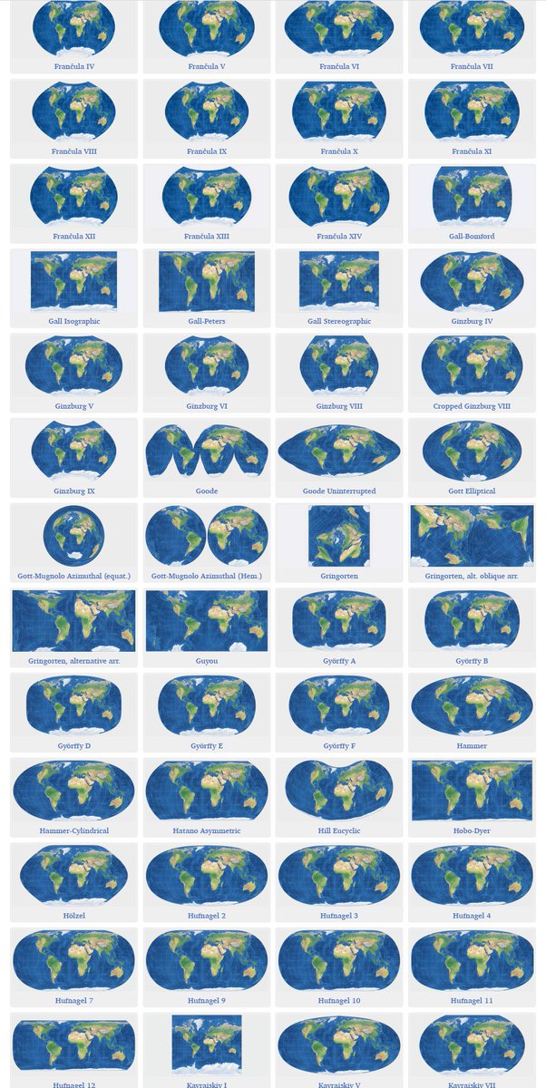
Tobias Jung has quite fascinating long list of #mapprojections in case someone runs out of ideas. 😅 map-projections.net/singleview.php

STREEEETCH!!!!! What happens when you flatten a globe into a map??? Uh oh!!! I see distortions! Applying our spatial perspective skills! #MapProjections #LearnersToday #LeadersTomorrow @BrenhamHS
And today I learned about the 5 May 1953 Nancy projection. Envious that Nancy doesn't seem to have the orange peel problems everyone else runs into. #creativeCarto #mapProjections
We'll be talking #Lego and #mapprojections with our special guest @BojanSavric when we 'ask a cartographer' during today's ##EsriUC #MappyHour. Join us at 4pm PDT.


#30DayMapChallenge 🗺️ (Day 26: #MapProjections) Perth, Western Australia, is often referred to as the world's most isolated major city. This map visualises the international flights departing from Perth. This map uses an #AzimuthalEquidistantProjection with Perth as the origin.
Happy GIS Day! Here I am showing Jack Dangermond how I teach map projections with my illuminated globe... #MapProjections #GISDay

Teaching globe to map and why it’s so difficult to accurately represent Earth on a map… what better way than to get Y7 to try for themselves! Peel away… #mapprojections #teachgeography

Something went wrong.
Something went wrong.
United States Trends
- 1. #BaddiesUSA 59.6K posts
- 2. Rams 29.3K posts
- 3. #LAShortnSweet 21.6K posts
- 4. Scotty 9,786 posts
- 5. Cowboys 101K posts
- 6. Chip Kelly 8,636 posts
- 7. Eagles 141K posts
- 8. TOP CALL 3,331 posts
- 9. #ITWelcomeToDerry 15.3K posts
- 10. #TROLLBOY 1,964 posts
- 11. Raiders 67.7K posts
- 12. sabrina 62.2K posts
- 13. Stafford 15K posts
- 14. Stacey 25.7K posts
- 15. Bucs 12.3K posts
- 16. #RHOP 12.1K posts
- 17. Baker 20.9K posts
- 18. Ahna 7,120 posts
- 19. billie 19.1K posts
- 20. Vin Diesel 1,237 posts