#geopython résultats de recherche

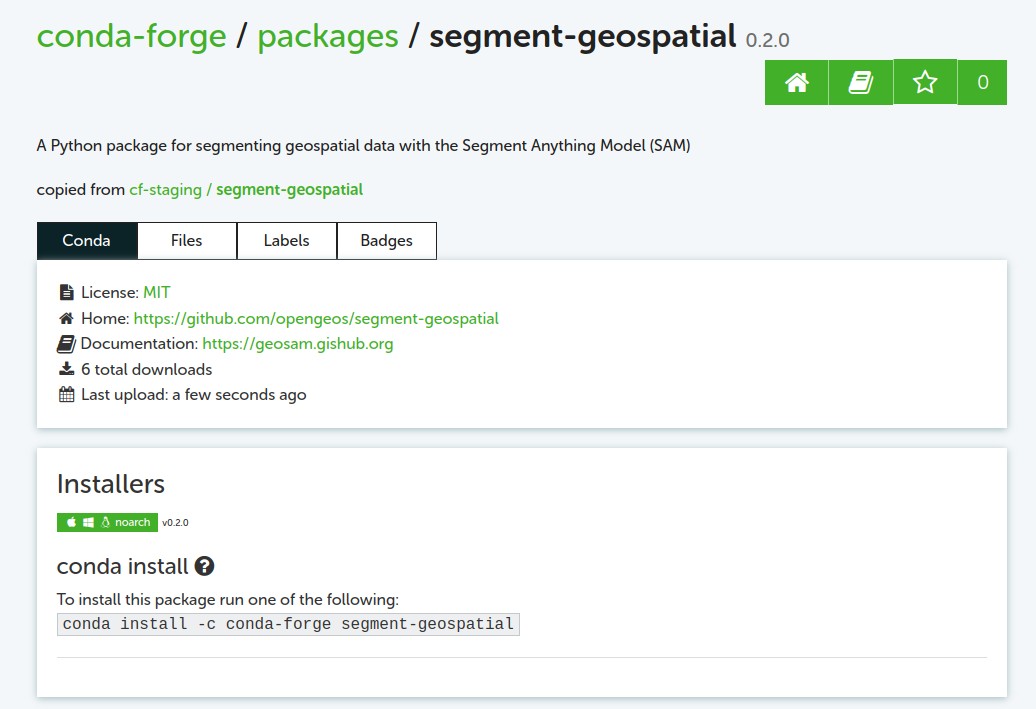
segment-geospatial v0.3.0 is out - segmenting satellite imagery with the Segment Anything Model (SAM). GitHub: github.com/opengeos/segme… Docs: samgeo.gishub.org Notebook: samgeo.gishub.org/examples/satel… #segmentanything #deeplearning #geopython #geospatial
Introducing segment-geospatial, A Python package for segmenting geospatial data with the Segment Anything Model (SAM) GitHub: github.com/opengeos/segme… Docs: samgeo.gishub.org Notebook: samgeo.gishub.org/examples/satel… #segmentanything #deeplearning #geopython

It is always a delight to speak at @GeoPythonConf Switzerland 🇨🇭🏔🗻❄️ This time, I talked about Infrastructure as Software with Pulumi. #Python #Conference #GeoPython #Pulumi #Infrastructure #Code

Comparing two images with a slider in a #Jupyter Notebook with only one line of code 👇 Notebook: leafmap.org/notebooks/76_i… #leafmap #geopython #dataviz #geospatial

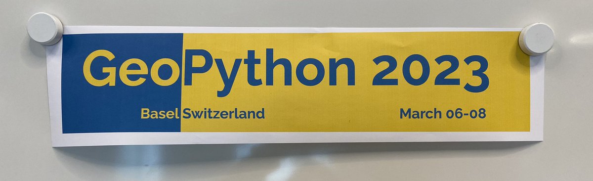
بشهر مارس سينطلق مؤتمر #Geopython والذي يركز على برمجيات البايثون ونظم المعلومات الجغرافية سوف يتناول عدة مواضيع مثل: نظم المعلومات الجغرافية المدن الذكية قواعد البيانات المكانية البيانات الضخمة رؤية الكمبيوتر التعلم الآلي والعميق النمذجة خرائط الجوال 2023.geopython.net

The segment-geospatial Python package is now available on conda-forge. Install it with one command: mamba install -c conda-forge segment-geospatial #segmentanything #geospatial #geopython

So nice we are giving it twice! Given the number of participants, the Doing Geospatial in Python workshop is being run in two parallel classes by the team! #foss4g2023 #geopython

How to create a #Python package and publish it on PyPI in less than 5 minutes? Video: youtu.be/EIwLZiTuYoA Demo: geosdemo.gishub.org #geospatial #geopython


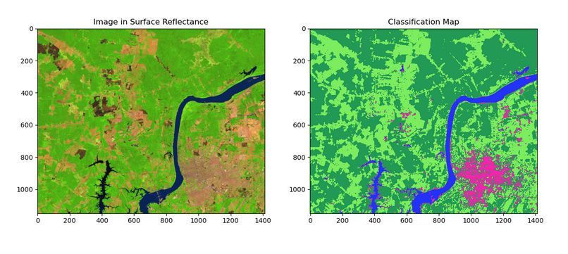
🛰️ A new paper "scikit-eo: A Python package for Remote Sensing Data Analysis" on a tool for #LULC analysis with various machine learning and neural networks algorithms.🛰️ Article: buff.ly/4c34uhg Software: buff.ly/4bT244U #geopython #remotesensing #landcover


Looking forward to showing @GeoPythonConf how to create an on-demand “SharePoint-as-an-Interface” pipeline for automated data processing using GitHub Actions for secure free cloud compute. Code is here 👉 github.com/john-sandall/g… #GeoPython #GeoPython2023 #Basel 🇨🇭🪨🐍


GeoPython 2023 - Workshop “Writing an efficient code for GeoPandas and Shapely in 2023” by @jorisvdbossche @martinfleis #python #geopythonconf #geopython

Say hi to ‘Geocomputation with Python’! Our new blog post introduces the book about working with spatial data in Python. geocompx.org/post/2023/geoc… #geopython #python #geocompx #gischat


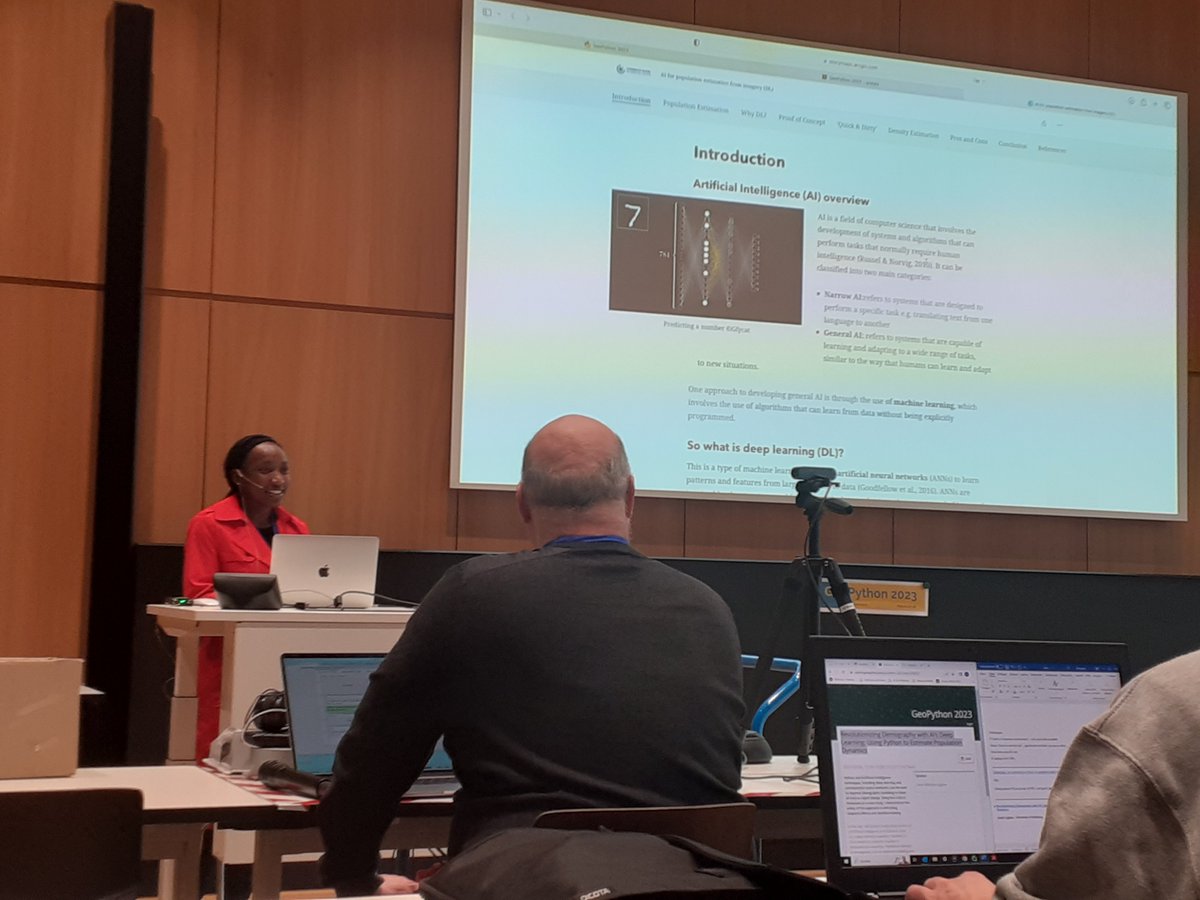
Proud to see our #student Lisah presenting #research at #GeoPython 2023. Revolutionizing Demography with AI’s Deep Learning: Using Python to Estimate Population Dynamics #artificialintelligence #Copernicus #DigitalEarth #GeoDataScience #MSc #PLUS #UBS #WomeninCopernicus


Visualizing #lidar point clouds with Whitebox Workflows (WbW) v1.3. #geopython #gis #gischat WbW: whiteboxgeo.com/whitebox-workf…

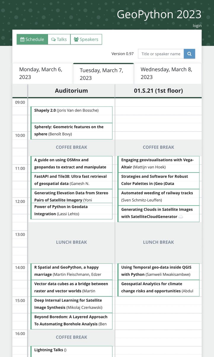
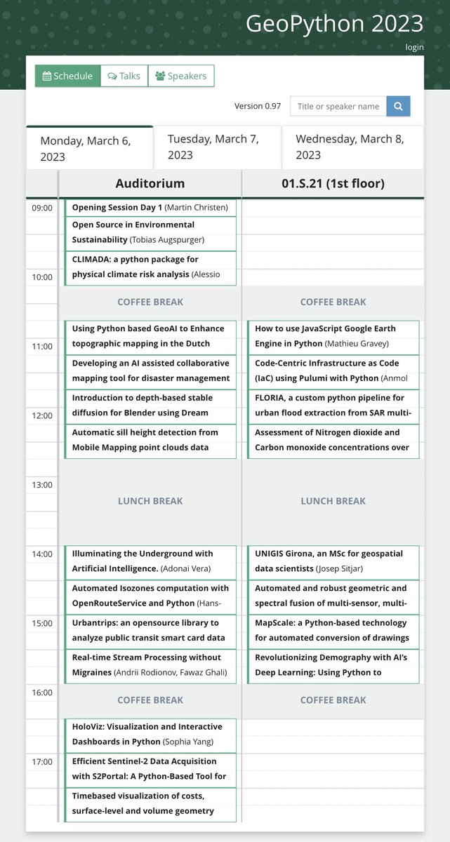
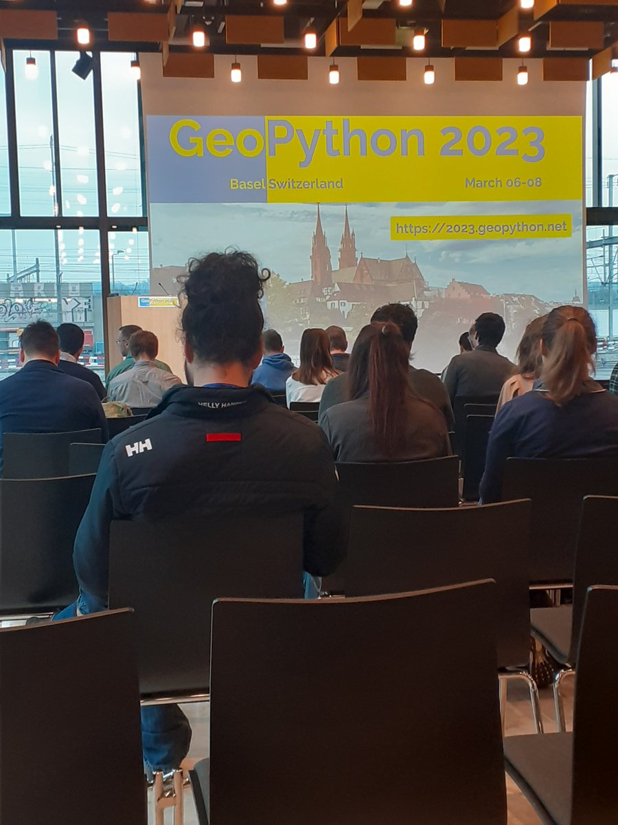
The first part of accepted talks is now available at: 2023.geopython.net/talks.html From GIS and mapping to geospatial webservices and machine learning, there's something for everyone. #Python #GeoPython #geospatial #MachineLearning

And that’s wrap! Doing Geospatial in Python workshop done for FOSS4G 2023! For the first time, we ran two parallel workshops. Kudos to @tzotsos @pvgenuchten @luis_m_de_sousa @justb4 @francbartoli - fantastic job again everyone! #geopython #foss4g

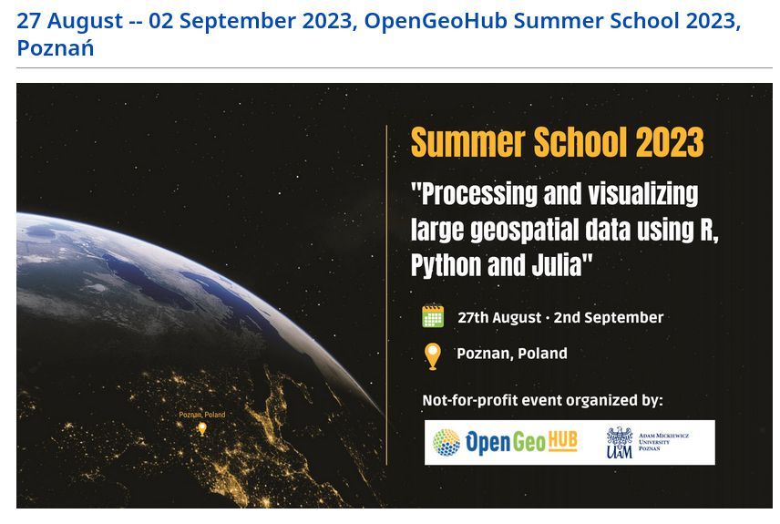
You can find links to all of the OpenGeoHub Summer School 2023 recordings and materials at github.com/Nowosad/OGH_su…. Learn about #rspatial #geopython #juliageo #gischat


Parkopedia will be at the @GeoPythonConf, on 6-8 March in Basel, Switzerland and present ‘FastAPI and Tile38: Ultra fast retrieval of #geospatial data,’ on March 7 at 11:15 AM (CET). Join us: bit.ly/3xQI3dE #Python #GeoPython #MachineLearning

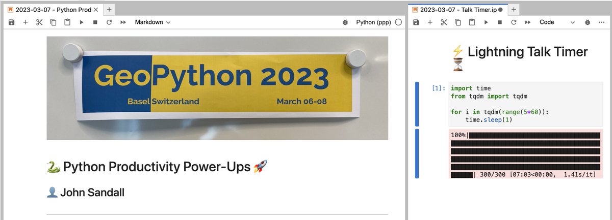
Great to share some of my favourite #Python productivity tips @GeoPythonConf! 🐍❤️🗺️ 📒 You can find my lightning talk notebook here: github.com/john-sandall/p… #GeoPython #GeoPython2023 #Basel


pygeoapi 0.21.0 released! github.com/geopython/pyge… @opengeospatial @osgeo #foss4g #geopython


Day 66 of #LearnInPublic Today I explored powerful GIS Analysis Tools: 📍 Buffer – Find what's nearby ✂️ Clip – Cut layers to areas of interest 🧩 Intersect – Find overlaps 🧬 Select by Attribute – Query like a pro Unlocking real spatial insights! #GIS #GeoPython #GISDeveloper
Day 65 of #LearnInPublic Today I explored different GIS data formats 🌍 🧭 Vector: .shp, .geojson, .kml 🖼 Raster: .tif, .img, .asc 📊 Tabular: .csv, .dbf Learning how GIS speaks through files is 🔑 to every project! #GIS #GeoPython #GISDeveloper
Day 64 Today I explored Georeferencing – the magic of aligning maps to real-world coordinates 🌍 📌 Learned how to assign spatial reference to scanned maps using control points Another powerful GIS skill unlocked! #GIS #GeoPython #GISDeveloper
Day 63 Today I tackled the building blocks of data: ✅ Lists (changeable GPS points) ✅ Tuples (fixed bounding boxes) ✅ Dictionaries (code-to-label maps) Bit tricky at first, but now it’s clicking! #Python #GIS #GeoPython

🎯 Whether you're mapping cities, tracking climate, or managing resources — these tools power it all. 👉 Learn. Build. Solve. Explore more at sdssn.org #PythonGIS #SpatialAnalysis #GeoPython #SDSSN #GISCommunity
Day 61 Diving deeper into #Python today: ✅ Mastered *args & **kwargs ✅ Understood variable scope (local vs global) ✅ Created sleek lambda functions 💡 Challenging but rewarding—one step closer to becoming a #GISDeveloper! 🌍🧠 #GeoPython #LearningByDoing
Day 54 Just explored how #Python powers real-world GIS! From land use change detection to disaster mapping, Python + GIS = smart spatial solutions Libraries used: geopandas, rasterio, numpy, matplotlib #GIS #GeoPython #SpatialAnalysis #Geoinformatics #RemoteSensing #QGIS #ArcGIS
Day 53 Just Explored Basics of Python for GIS! 🐍🗺️ It helps me: ✅ Make maps faster ✅ Analyze data easily ✅ Work with shapefiles and rasters Excited to explore more! 🌍 #GIS #Python #GeoPython #Mapping #Geospatial

JupyterGIS: Pioneering Web-based, Collaborative, and Open-source GIS Tools | #GeoPython 2025 submit.geopython.net/geopython-2025… おもしろそうなの作ってるわ😃
duckdb-geography : Global vector data in DuckDB | #GeoPython 2025 submit.geopython.net/geopython-2025… 球面座標を扱えるようにしちゃうのか🧐
GeoPython 2025 detailed schedule is now available 2025.geopython.net/schedule #GeoPython #geospatial #geo #conference

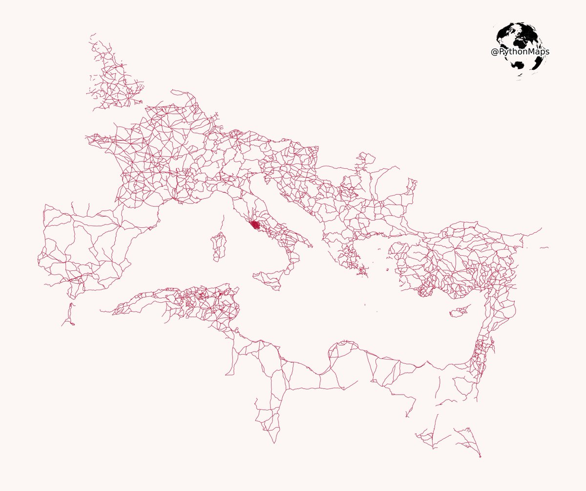
All roads lead to Rome. This map highlights the vast infrastructure of the Roman Empire, showcasing how far their famous roads extended. #Python #DataScience #Geopython #DataVisualization #Rome #Maps

event february 2025 - GeoPythonConf @GeoPythonConf This is the official Twitter account of the GeoPython Conference. Next event: February 24-26, 2025. #python #geo #geopython

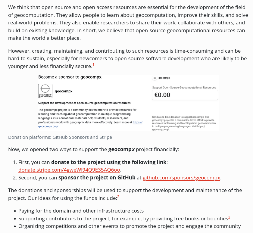
Advancing geocomputation through open-source software! 🗺️ Consider supporting our continued development of free, powerful spatial analysis resources, such as Geocomputation with R. Learn how to contribute at buff.ly/3OMFPUU #rstats #rspatial #geopython #gecompx

We extended the GeoPython 2025 submission deadline for talks/workshops to November 24 for those who missed the deadline. There will be no further extension. 2025.geopython.net/callforspeakers #geopython #geospatial #geo
📢 GeoPython 2025: Call for Speakers closes soon! 📢 Share your knowledge and insights in Python and Geospatial tech with a passionate community. The deadline is approaching on November 15, 2024 Submit here: 2025.geopython.net/callforspeakers #GeoPython #Python #Geospatial


🛰️ A new paper "scikit-eo: A Python package for Remote Sensing Data Analysis" on a tool for #LULC analysis with various machine learning and neural networks algorithms.🛰️ Article: buff.ly/4c34uhg Software: buff.ly/4bT244U #geopython #remotesensing #landcover
All roads lead to Rome. This map highlights the vast infrastructure of the Roman Empire, showcasing how far their famous roads extended. #Python #DataScience #Geopython #DataVisualization #Rome #Maps
It is always a delight to speak at @GeoPythonConf Switzerland 🇨🇭🏔🗻❄️ This time, I talked about Infrastructure as Software with Pulumi. #Python #Conference #GeoPython #Pulumi #Infrastructure #Code

I am going to do a 30 day challenge where I talk about geospatial python.🐍 So.. Day 1: 🌐 Dive into the basics of geospatial data processing using Python! Today's tip: Use the geopandas library to easily read, write, and manipulate spatial data. #GeoPython #GIS

Proud to see our #student Lisah presenting #research at #GeoPython 2023. Revolutionizing Demography with AI’s Deep Learning: Using Python to Estimate Population Dynamics #artificialintelligence #Copernicus #DigitalEarth #GeoDataScience #MSc #PLUS #UBS #WomeninCopernicus
The segment-geospatial Python package is now available on conda-forge. Install it with one command: mamba install -c conda-forge segment-geospatial #segmentanything #geospatial #geopython
بشهر مارس سينطلق مؤتمر #Geopython والذي يركز على برمجيات البايثون ونظم المعلومات الجغرافية سوف يتناول عدة مواضيع مثل: نظم المعلومات الجغرافية المدن الذكية قواعد البيانات المكانية البيانات الضخمة رؤية الكمبيوتر التعلم الآلي والعميق النمذجة خرائط الجوال 2023.geopython.net
Day 7: 🌐 Elevate your geospatial analyses! Master spatial joins with Geopandas to seamlessly combine datasets based on spatial relationships. Extract deeper insights and make more informed decisions. 🗺️✨ #SpatialAnalysis #GeoPython #Geopandas

Say hi to ‘Geocomputation with Python’! Our new blog post introduces the book about working with spatial data in Python. geocompx.org/post/2023/geoc… #geopython #python #geocompx #gischat
How to create a #Python package and publish it on PyPI in less than 5 minutes? Video: youtu.be/EIwLZiTuYoA Demo: geosdemo.gishub.org #geospatial #geopython
Visualizing #lidar point clouds with Whitebox Workflows (WbW) v1.3. #geopython #gis #gischat WbW: whiteboxgeo.com/whitebox-workf…

Working on mapping atmospheric particles and chemicals to see what I can find about the East Palestine train derailment. Here's a WIP of global atmospheric PM 2.5. Stay tuned! #gischat #geopython #python Data: NASA Goddard Earth Observing System

GeoPython 2023 - Workshop “Writing an efficient code for GeoPandas and Shapely in 2023” by @jorisvdbossche @martinfleis #python #geopythonconf #geopython
You can find links to all of the OpenGeoHub Summer School 2023 recordings and materials at github.com/Nowosad/OGH_su…. Learn about #rspatial #geopython #juliageo #gischat
You can find an (updated) list of the OpenGeoHub summer school 2023 (#ogh2023) workshop materials at buff.ly/44uKIaT. #rspatial #geopython #juliageo #gischat


So nice we are giving it twice! Given the number of participants, the Doing Geospatial in Python workshop is being run in two parallel classes by the team! #foss4g2023 #geopython
Something went wrong.
Something went wrong.
United States Trends
- 1. Yamamoto 46.1K posts
- 2. #DWTS 43.1K posts
- 3. Brewers 41.1K posts
- 4. #TexasHockey 3,328 posts
- 5. #FlyTogether 2,605 posts
- 6. Ohtani 13.9K posts
- 7. Young Republicans 72.1K posts
- 8. halsey 8,113 posts
- 9. Jared Butler N/A
- 10. Kreider 1,178 posts
- 11. Growth Path 1,592 posts
- 12. #Dodgers 16K posts
- 13. #MakeOffer 10.3K posts
- 14. Domain For Sale 10.7K posts
- 15. Jarry N/A
- 16. Robert 106K posts
- 17. Haji Wright 1,197 posts
- 18. Will Richard 2,612 posts
- 19. Roldan 2,660 posts
- 20. TOKYO NARITA N/A