#geojson search results


free elevation contour generator! Select an area, click generate contours, and download as #geojson ... easy!

Which format to use? Shapefile, GeoJSON and GeoPackage? Tutorial Link: youtu.be/ACXTxnWl-hg?si… #shapefile #GeoJSON #GeoPackage #GIS #geospatial


Probando dropchop\.io/ para Geolocalizar Alertas #Suricata_IDS / #GeoJSON. cat eve.json | jq -c 'select(.alert) | [.src_ip,.dest_ip,.alert.signature,.alert.severity,.alert.category]' .... --lat Lat --lon Lon --crs EPSG:4269 --zero --blanks
![seguridadyredes's tweet image. Probando dropchop\.io/ para Geolocalizar Alertas #Suricata_IDS / #GeoJSON.
cat eve.json | jq -c 'select(.alert) | [.src_ip,.dest_ip,.alert.signature,.alert.severity,.alert.category]' ....
--lat Lat --lon Lon --crs EPSG:4269 --zero --blanks](https://pbs.twimg.com/media/GuXwQJRWcAA8MAK.jpg)

Hachure! Based on an arcticle by Daniel Huffman i have developed an algorithm that generates #Hachure lines for a given portion of a digital elevation model (DEM). Illumination can be simulated to generate extra depth. Output is exportable as #geojson. 1/


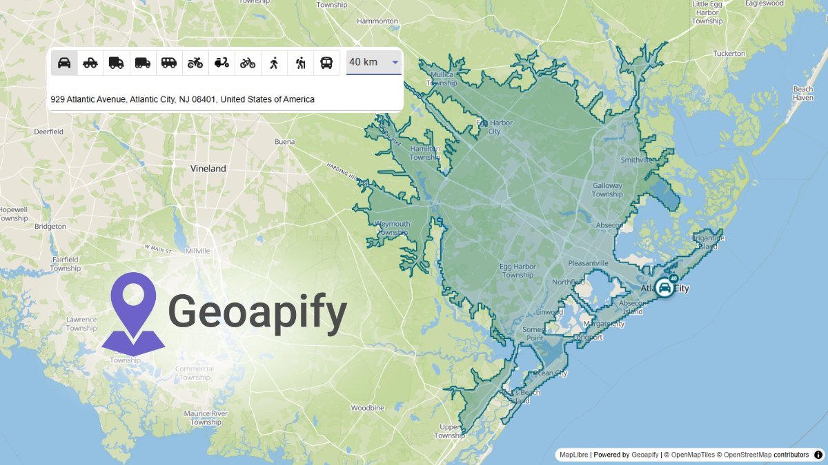
Build reachability maps in your favorite libraries! 🗺️ Geoapify Isoline API returns GeoJSON – perfect for Leaflet, MapLibre, or OpenLayers. Quick to integrate, easy to visualize. Explore → geoapify.com/isoline-api/ #IsolineAPI #GeoJSON #MappingSolutions #Developers #Geoapify

産総研地質調査総合センターの地質図Navi @How_many_files に #GeoJSON をドラッグ&ドロップで表示できるの,便利ですね.知りませんでした.図は,シームレス地質図V2,地理院タイル(淡色地図),気象庁による震央分布(2024年1月1日〜)を重ねたもの.気象庁のデータがGeoJSONです.


【Leaflet】地図情報をスマートに整理!GeoJSONのfilterで、見たいカテゴリのピンだけを表示する方法を解説。 #Leaflet #GeoJSON #OpenStreetMap #高槻 #プログラミング教室 #AI広報 #Gemini saitodev.co/programming/ja…


A really cool collection for #GIS #data - 𝐓𝐡𝐞 𝐔𝐥𝐭𝐢𝐦𝐚𝐭𝐞 𝐋𝐢𝐬𝐭 𝐨𝐟 𝐆𝐈𝐒 𝐅𝐨𝐫𝐦𝐚𝐭𝐬 𝐚𝐧𝐝 𝐆𝐞𝐨𝐬𝐩𝐚𝐭𝐢𝐚𝐥 𝐅𝐢𝐥𝐞 𝐄𝐱𝐭𝐞𝐧𝐬𝐢𝐨𝐧𝐬. 𝐎𝐫𝐢𝐠𝐢𝐧𝐚𝐥 𝐚𝐫𝐭𝐢𝐜𝐥𝐞: lnkd.in/gwRYqvWK #geojson #geopandas #osmnx #rasterio #datascience


TIL #TopoJSON is a leaner version of #GeoJSON, cleverly maximizing efficiency by reusing elements through concepts like ‘arc’. It's amazing... #cs_internship en.wikipedia.org/wiki/GeoJSON#T…

disponibles 19002 #geojson de 🌲🌳🌴 con #datosabiertos e #interoperables #OpenStreetMap #natural=tree de #Valdiviacl proj: #ArboladoUrbano Público Virtual #AUPV | 📌📸🗺️🇨🇱


What advantages does the integration with #GeoJSON, the open standard format for #geospatialdata, offer us? 🗺️💻 This integration offers our users an efficient and versatile way to manage and visualize geographic information.
Alertas #Suricata_IDS #GeoJSON & #mmdblookup. ... cat ipalert |awk '{print $1}' FS=, > ip; for i in $(cat ip);do (mmdblookup --file Geo.mmdb --ip $i location|tr -d '{}"' |tr '\n' ' ' |tr '\n' ' '| awk -v laip="$i" '{print $5","$8","$11,","laip}');done..


Earthquake events following the sphere's rotation. Information for each event on click. Data dynamically updated from the #USGS online #GeoJSON showing the events of the past 30 days with magnitude ≥ 4. #cARTography #MakingMapsPretty #D3 #JavaScript #CSS #SVG

Like that one time you guys added support for #geojson and one could now have a live preview of their geospatial data….


It's true: WebP support has been now been added to your GitHub repos. 🎉 We think @martinwoodward is happy about it.

【Leaflet】地図情報をスマートに整理!GeoJSONのfilterで、見たいカテゴリのピンだけを表示する方法を解説。 #Leaflet #GeoJSON #OpenStreetMap #高槻 #プログラミング教室 #AI広報 #Gemini saitodev.co/programming/ja…

#Plans I want to finish the #ZarazJade refactor before the end of the year. It will include several additional features. 🚂 This means I will also bring back another project of mine! #GeoJSON is key to a good transit app! 🗺️ I love what I do! I end the year with a bang! 💥

GeoCSV, #GeoPackage y GeoJSON: ¿alternativas al shapefile? rviv.ly/o2mrny #GeoCSV #geoJSON

"Learn how to render GeoJSON Points, LineStrings & Polygons on a Leaflet map using Geoapify Places, Routing & Isoline APIs. Clean code, real data, live demos." by @geoapify #DEVCommunity dev.to/geoapify-maps-… #Leaflet #GeoJSON #WebDev

Leafletで複数ピンをGeoJSONでスマート管理!クリックでURL遷移も実装するWeb地図アプリ開発の裏技を公開! #Leaflet #GeoJSON #Web開発 #高槻 #プログラミング教室 #AI広報 #Gemini saitodev.co/programming/ja…
Build reachability maps in your favorite libraries! 🗺️ Geoapify Isoline API returns GeoJSON – perfect for Leaflet, MapLibre, or OpenLayers. Quick to integrate, easy to visualize. Explore → geoapify.com/isoline-api/ #IsolineAPI #GeoJSON #MappingSolutions #Developers #Geoapify

🚀 Learn how to add shapefiles (GeoJSON) in CesiumJS with visibility & opacity controls! Check it out: manyatechnologies.com/add-geojson-ce… #CesiumJS #GeoJSON #WebGIS #SpatialData #ManyaTechnologies #Shapefile

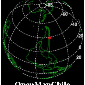
🌍 Con D3.js + #Canvas en #JavaScript puedes crear un globo terráqueo interactivo que rota automáticamente. ✅ Proyección ortográfica ✅ Animación en tiempo real ✅ Datos #GeoJSON Código: codepen.io/mentesgeeks/pe… #maths #informatica #ciencia #webdevelopment #cssart #webdesign
GeoCSV, #GeoPackage y GeoJSON: ¿alternativas al shapefile? rviv.ly/o2mrny #GeoCSV #geoJSON

Convert #geojson #gis #shapefile in #coco annotation for train your #computervision #yolo model #objectdetection #segmentation github.com/lindonepi/GeoJ…

Like that one time you guys added support for #geojson and one could now have a live preview of their geospatial data….
It's true: WebP support has been now been added to your GitHub repos. 🎉 We think @martinwoodward is happy about it.

d3-geo-polygon Geometric and clipping operations for spherical polygons, with advanced polyhedral map projections. #d3 #mapping #geojson #dataviz
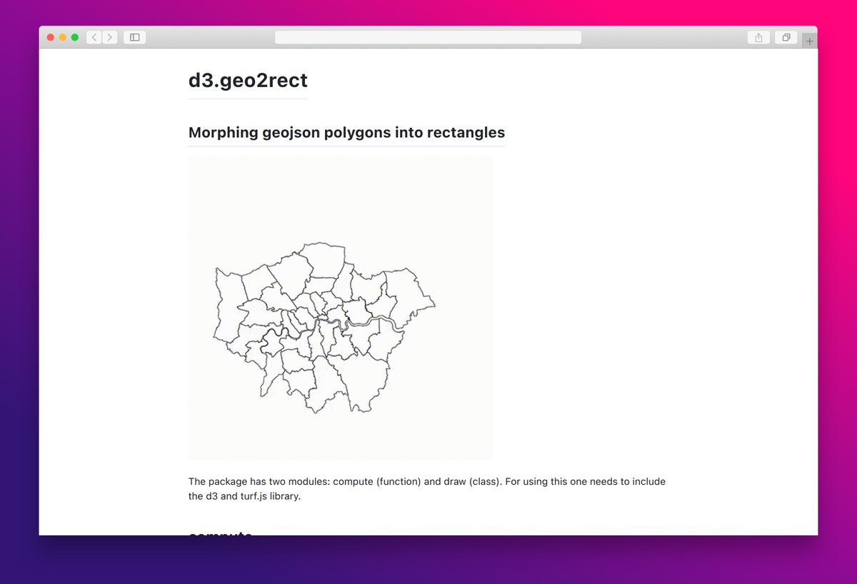
d3.geo2rect lets you morph GeoJSON polygons into rectangles for easy visualization and analysis. #dataviz #geojson #d3js

🌍💻 El formato de notación de objetos de JavaScript (𝗝𝗦𝗢𝗡) permite definir de forma sencilla y eficaz las características de cualquier objeto. Leer más: bit.ly/tiempo_GeoJSON #WebGIS #javascript #GeoJSON #JSON


#geojson のジオメトリと交差する #xyzタイル のタイルIDリストをCSV形式で出力するスクリプトを作成しました。必要なタイルだけをダウンロードするときなどに使用する想定です。 github.com/hirofumikanda/…
github.com
GitHub - hirofumikanda/geojson-intersecting-tilelist
Contribute to hirofumikanda/geojson-intersecting-tilelist development by creating an account on GitHub.


Le temps pour dessiner une carte géoréférencée du Royaume France au XVIIIe s. ? 20 heures de travail ! Je rendrai libre mon #geojson. #openscience

#Suricata_IDS. Po na, pisha. Aquí arreglando scripts #GeoJSON para publicarlos. El por curl -s quedan los cambios de versiones. arreglao !! Fuente datos: cat eve.json | jq -c 'select(.alert and .http) | [.src_ip,.dest_ip,.alert.signature,.alert.severity,.http.hostname]'
![seguridadyredes's tweet image. #Suricata_IDS. Po na, pisha. Aquí arreglando scripts #GeoJSON para publicarlos. El por curl -s quedan los cambios de versiones.
arreglao !!
Fuente datos:
cat eve.json | jq -c 'select(.alert and .http) | [.src_ip,.dest_ip,.alert.signature,.alert.severity,.http.hostname]'](https://pbs.twimg.com/media/EUOhjreWsAInAVz.jpg)

Voici les fichiers #GeoJSON et CSV en #opendata des PK (points hecto/kilométriques) du réseau ferroviaire national #rfn @SNCFReseau ! Les données sources n'étant pas toujours aussi précises que désiré, ce n'est pas toujours parfait mais ça rend déjà bien ! github.com/nicolaswurtz/e…


{geojsonsf} is getting better support for reading large files from disk. In this example I'm reading a 2.2Gb geojson file of ~9million buildings in Texas. #rstats #rspatial #geojson #sf

En train de joyeusement encoder du #geojson, me disant que finalement la géomatique je commence à comprendre... et puis je découvre la ligne #sncf de Coni à Vintimille 😱 Y'a de quoi se faire quelques « nœuds » au cerveau 😅

#Suricata_IDS #Zeek_IDS var/log/remote/..., etc Preparando formato #GeoJSON para localización de IPs/alertas/var log remote automática sin pasar por GoogleMaps. (fase de puebas)


Recordatorio: No al Shapefile. En unas pruebas para proyecto masivo en el que un requisito es generar muuuchos ficheros gráficos tras un cálculo pesado, adivinad dónde estaba el cuello de botella.... #R #geojson #Noalshapefile


#ElasticMaps in #Kibana is now production-ready, and adds the ability to import layers and features from #GeoJSON files. Canvas levels up with new templates, documentation, and enhanced interaction features. Plus, #Kerberos support comes to Kibana → go.es.io/2OxBsAX


Wie man mittels der #JavaScript-Bibliothek #Leaflet #GeoJSON-Daten auf einer Karte in eigenen Anwendungen darstellen kann, zeigt euch @tobiastrelle in seinem neuen Blogpost: hubs.ly/H0cBBkS0

#Bro_IDS / #Zeek_IDS localizando eventos con #GeoJSON añadiendo campos... cat files.log | ag 'application\/(vnd|x-dos|x-gz)' | jq -c [.tx_hosts,.rx_hosts,.mime_type,.source,.resp_lat,.resp_long,.fuid] | ag -v null | tr -d '[]"' | sed '1i host_tx,host_rx,mime,origen,lat,lon,fuid'
![seguridadyredes's tweet image. #Bro_IDS / #Zeek_IDS localizando eventos con #GeoJSON añadiendo campos...
cat files.log | ag 'application\/(vnd|x-dos|x-gz)' | jq -c [.tx_hosts,.rx_hosts,.mime_type,.source,.resp_lat,.resp_long,.fuid] | ag -v null | tr -d '[]"' | sed '1i host_tx,host_rx,mime,origen,lat,lon,fuid'](https://pbs.twimg.com/media/D_A_e3wXsAAZkW2.jpg)
![seguridadyredes's tweet image. #Bro_IDS / #Zeek_IDS localizando eventos con #GeoJSON añadiendo campos...
cat files.log | ag 'application\/(vnd|x-dos|x-gz)' | jq -c [.tx_hosts,.rx_hosts,.mime_type,.source,.resp_lat,.resp_long,.fuid] | ag -v null | tr -d '[]"' | sed '1i host_tx,host_rx,mime,origen,lat,lon,fuid'](https://pbs.twimg.com/media/D_A_e3vWwAE-T2K.jpg)

Automatische Dauerzählstellen für den Radverkehr in Berlin gist.github.com/johnjohndoe/d2… #fahrrad #geojson @codeforbe @radneukoelln @ADFC_Berlin @CMBerlin @CMlerBerlin @radentscheid


I just released a tutorial which demonstrates how to create and interact with geofences using #GeoJSON data, @MongoDB geospatial queries, and @Mapbox. Check it out at developer.mongodb.com/how-to/locatio… #NoSQL #JavaScript


ed ora @BBBikeDE permette l'esportazione dei dati di #openstreetmap anche in formato #geojson extract.bbbike.org/?format=geojso…


Learn how to format data into #GeoJSON with #JavaScript to be used with HERE XYZ in this tutorial by Nic Raboy (@nraboy). buff.ly/2EjV9Vm cc @heredev

Alertas #Suricata_IDS #GeoJSON & #mmdblookup. ... cat ipalert |awk '{print $1}' FS=, > ip; for i in $(cat ip);do (mmdblookup --file Geo.mmdb --ip $i location|tr -d '{}"' |tr '\n' ' ' |tr '\n' ' '| awk -v laip="$i" '{print $5","$8","$11,","laip}');done..

Sharing and collaborating made easy. Experiment with importing lightweight and easily human-readable #GeoJSON data into points on a Google Map → goo.gl/1pFnsN
Something went wrong.
Something went wrong.
United States Trends
- 1. #UFC322 165K posts
- 2. Islam 269K posts
- 3. Morales 37.2K posts
- 4. Valentina 15.9K posts
- 5. Sark 6,071 posts
- 6. Kirby 18.8K posts
- 7. Georgia 89.2K posts
- 8. Ilia 5,641 posts
- 9. Khabib 9,217 posts
- 10. Zhang 26.9K posts
- 11. Ole Miss 12.4K posts
- 12. #GoDawgs 9,708 posts
- 13. Leon 74.4K posts
- 14. Dagestan 2,089 posts
- 15. Arch 22.5K posts
- 16. Sean Brady 6,879 posts
- 17. Dillon Danis 10.9K posts
- 18. Tanner Wall N/A
- 19. Usman 10.5K posts
- 20. Ahmad Hardy 1,352 posts