#gistutorial risultati di ricerca

#SpatialAnalysis #GISTutorial #GeospatialTech #DroneMapping #DataAccuracy #SpatialData #TechTrends #GISAnalytics #MappingSkills #PrecisionMapping #DataScience #SpatialVisualization #GeospatialInsights #TechInnovation #GISLearning

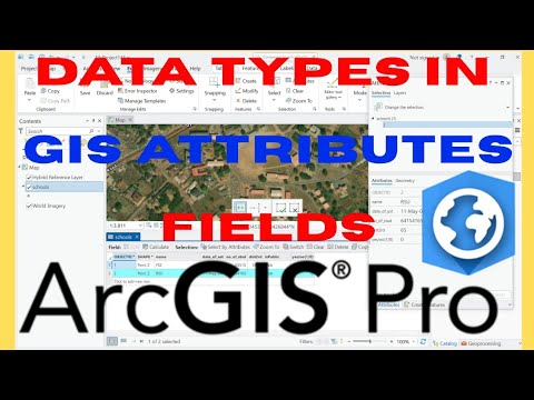
Hello In this Tutorial youtu.be/ybnLeNZceHc, learn how to correctly set and manage data types in ArcGIS Pro attribute tables — including Text, Integer, Decimal (Float), Date, Boolean, and more. Thank you... #ArcGISPro #GISTutorial #ArcGISDataTypes #GISMapping #ArcGIS
youtube.com
YouTube
How to Set Data Types in ArcGIS Pro Attribute Table
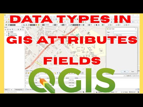
Hello In this Tutorial youtu.be/W1o1y9lsTps, learn how to correctly set and manage data types in QGIS attribute tables — including Text, Integer, Decimal (Float), Date, Boolean, and more. Thank you... #GISTutorial #QGISDataTypes #GISMapping #QGISForBeginners #SpatialData
youtube.com
YouTube
How to Set Data Types in QGIS Attribute Table | Text, Integer, Date,...
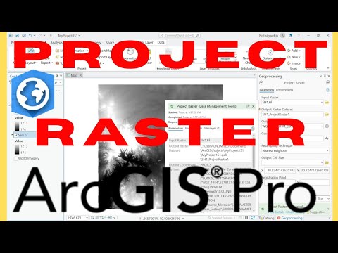
Hello Learn how to reproject a raster in ArcGIS Pro using the Project Raster tool by watching this video youtu.be/saT6pEGzMUE. Thank you. #ArcGISPro #RasterReprojection #GISTutorial #GISAnalysis #SpatialData #CoordinateSystems
youtube.com
YouTube
How to Reproject Raster in ArcGIS Pro | Project Raster | Warp Raster
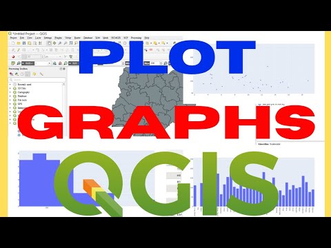
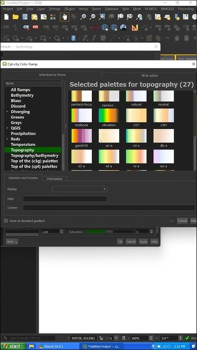
Hello Watch this video youtu.be/W2Sj1xRMcvg and Learn How to Visualise your GIS Data with Graphs. Thank you. #QGIS #GISTutorial #QGISGraphs #DataVisualization #GISMapping #SpatialAnalysis #QGISCharts #QGISTips #GeoVisualization
youtube.com
YouTube
How to Make Graphs in QGIS | QGIS Create Graphs

Point Clustering in GIS youtu.be/sfi0pSndh_g?si… #gistutorial #qgis #dbscan
youtube.com
YouTube
Point Clustering in GIS
Completed Terrain Visualization in QGIS Using Single Layer DEM #qgis #terrain #gistutorial youtube.com/shorts/CXK31VI…
youtube.com
YouTube
Completed Terrain Visualization in QGIS Using Single Layer DEM #qgis...
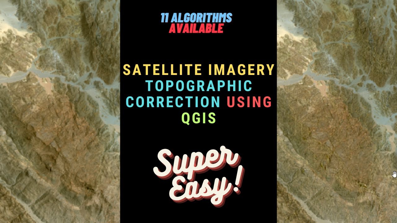
Satellite Imagery Topographic Corre ction in QGIS youtu.be/k4EDLmEaIBk via @YouTube #qgis #terraform #gistutorial #geospatial #topographicremoval
youtube.com
YouTube
Satellite Imagery Topographic Correction in QGIS (Very Easy and Many...
Polygon Simplification in GIS. Avoid Gaps and Slivers, Reduced File Size, consistent appearance, Attributes preservation. youtu.be/fnyTF8JQqPo?si… via @YouTube #gistutorial #arcgis #gis #geojson
How to Generate Cached Online Basemap for Offline Use. Part 1 youtu.be/crCZsWpRgXc via @YouTube #gistutorial #mobac #geospatial #gis #mapping

youtube.com
YouTube
How to Generate Cached Online Basemap for Offline Use. Part 1. How to...
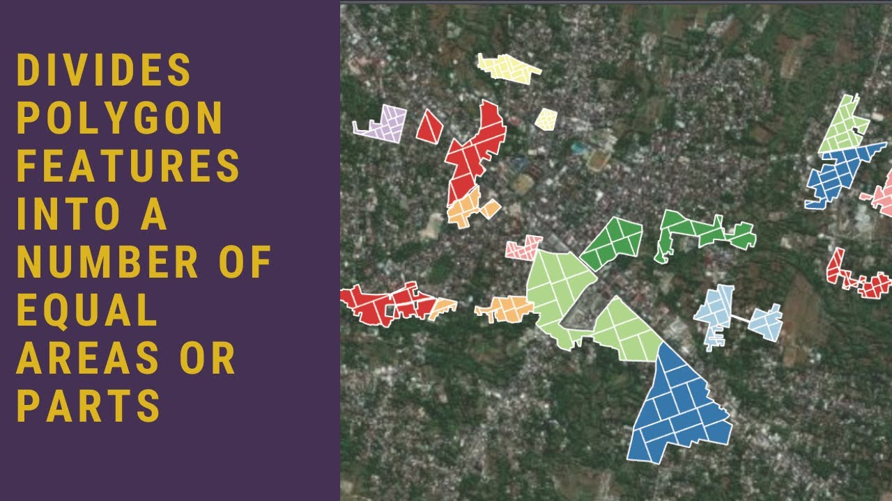
Divides Polygon Features into a Number of Equal Areas or Parts in ArcGIS... youtu.be/-0GubFbluhM?si… #arcgispro #gistutorial #arcgistutorial #mapping #geospatial
youtube.com
YouTube
Divides Polygon Features into a Number of Equal Areas or Parts in...
Offline Basemap for Android and IOS Field Mapping Part 2 ArcGIS Mobile Map Package Solution youtu.be/daPwOwzQRN4 #arcgis #mobilemapping #gistutorial #fieldmaps #mapping #geospatial
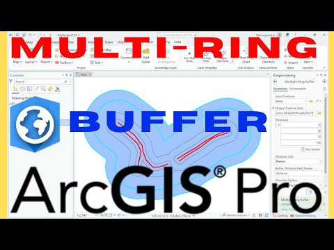
Hello Watch this video youtu.be/godXOldOEyM and Learn how to create and use Multi-Ring Buffers in ArcGIS Pro. Thank you. #ArcGISPro #MultiRingBuffer #GISTutorial #SpatialAnalysis #ProximityAnalysis #GISTools #ArcGIS #BufferAnalysis #Geospatial #Mapping 27.08.25
youtube.com
YouTube
Multi Ring Buffer in ArcGIS Pro
Offline Basemap for Android/IOS Field Mapping Part 4 KMZ SuperOverlay youtu.be/jAjjsyBJ7rQ via @YouTube #gis #gistutorial #android #ios #mapping
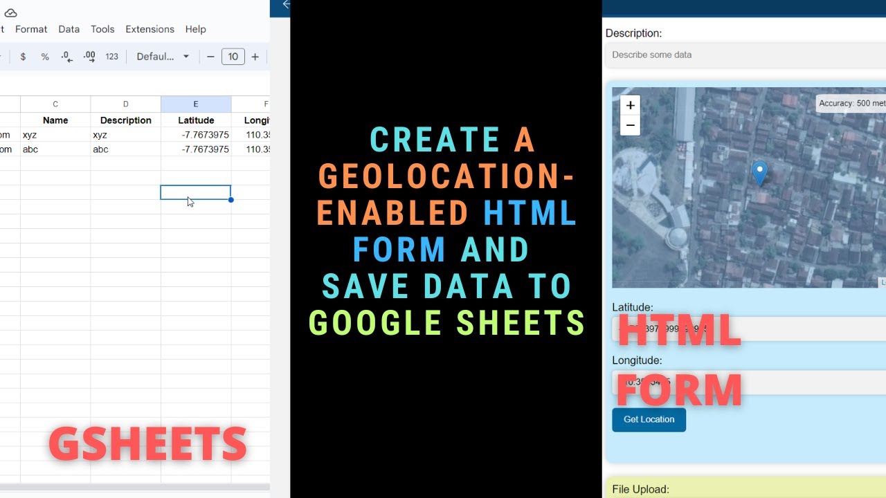
Create a Geolocation Enabled HTML Form and Save Data to Google Sheets youtu.be/FQJ0vQ4UuUM #surveyform #geolocation #gistutorial #surveying
youtube.com
YouTube
Create a Geolocation Enabled HTML Form and Save Data to Google Sheets
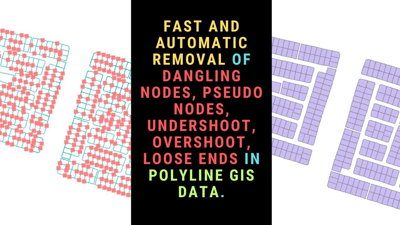
Fast and Automatic Removal of Dangling Nodes, Pseudo Nodes, and Loose Ends in Polyline GIS Data youtu.be/Y_D0boyh65w #arcgis #gistutorial #datacleaning #arcgistutorial
youtube.com
YouTube
Fast and Automatic Removal of Dangling Nodes, Pseudo Nodes, and Loose...
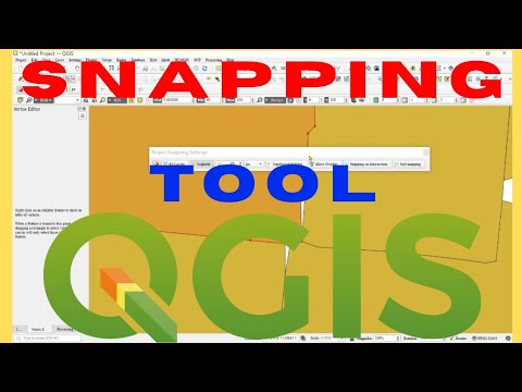
Hello In this Tutorial youtu.be/uqEqc2CBoJQ, you will Learn how to use the Snapping Toolbar in QGIS. Thank you. #QGIS #GISTutorial #Mapping #SpatialData #SnappingToolbar #QGISTips #GISAnalysis #Cartography #Digitizing
youtube.com
YouTube
Snapping Toolbar QGIS | How to Snap Features
Hello Watch this video youtu.be/W2Sj1xRMcvg and Learn How to Visualise your GIS Data with Graphs. Thank you. #QGIS #GISTutorial #QGISGraphs #DataVisualization #GISMapping #SpatialAnalysis #QGISCharts #QGISTips #GeoVisualization
youtube.com
YouTube
How to Make Graphs in QGIS | QGIS Create Graphs
Hello In this Tutorial youtu.be/uqEqc2CBoJQ, you will Learn how to use the Snapping Toolbar in QGIS. Thank you. #QGIS #GISTutorial #Mapping #SpatialData #SnappingToolbar #QGISTips #GISAnalysis #Cartography #Digitizing
youtube.com
YouTube
Snapping Toolbar QGIS | How to Snap Features
Hello Watch this video youtu.be/godXOldOEyM and Learn how to create and use Multi-Ring Buffers in ArcGIS Pro. Thank you. #ArcGISPro #MultiRingBuffer #GISTutorial #SpatialAnalysis #ProximityAnalysis #GISTools #ArcGIS #BufferAnalysis #Geospatial #Mapping 27.08.25
youtube.com
YouTube
Multi Ring Buffer in ArcGIS Pro
Hello Learn how to reproject a raster in ArcGIS Pro using the Project Raster tool by watching this video youtu.be/saT6pEGzMUE. Thank you. #ArcGISPro #RasterReprojection #GISTutorial #GISAnalysis #SpatialData #CoordinateSystems
youtube.com
YouTube
How to Reproject Raster in ArcGIS Pro | Project Raster | Warp Raster
Hello In this Tutorial youtu.be/ybnLeNZceHc, learn how to correctly set and manage data types in ArcGIS Pro attribute tables — including Text, Integer, Decimal (Float), Date, Boolean, and more. Thank you... #ArcGISPro #GISTutorial #ArcGISDataTypes #GISMapping #ArcGIS
youtube.com
YouTube
How to Set Data Types in ArcGIS Pro Attribute Table
Hello In this Tutorial youtu.be/W1o1y9lsTps, learn how to correctly set and manage data types in QGIS attribute tables — including Text, Integer, Decimal (Float), Date, Boolean, and more. Thank you... #GISTutorial #QGISDataTypes #GISMapping #QGISForBeginners #SpatialData
youtube.com
YouTube
How to Set Data Types in QGIS Attribute Table | Text, Integer, Date,...
Completed Terrain Visualization in QGIS Using Single Layer DEM #qgis #terrain #gistutorial youtube.com/shorts/CXK31VI…
youtube.com
YouTube
Completed Terrain Visualization in QGIS Using Single Layer DEM #qgis...
Divides Polygon Features into a Number of Equal Areas or Parts in ArcGIS... youtu.be/-0GubFbluhM?si… #arcgispro #gistutorial #arcgistutorial #mapping #geospatial
youtube.com
YouTube
Divides Polygon Features into a Number of Equal Areas or Parts in...
Point Clustering in GIS youtu.be/sfi0pSndh_g?si… #gistutorial #qgis #dbscan
youtube.com
YouTube
Point Clustering in GIS
#SpatialAnalysis #GISTutorial #GeospatialTech #DroneMapping #DataAccuracy #SpatialData #TechTrends #GISAnalytics #MappingSkills #PrecisionMapping #DataScience #SpatialVisualization #GeospatialInsights #TechInnovation #GISLearning
Polygon Simplification in GIS. Avoid Gaps and Slivers, Reduced File Size, consistent appearance, Attributes preservation. youtu.be/fnyTF8JQqPo?si… via @YouTube #gistutorial #arcgis #gis #geojson
How to Generate Cached Online Basemap for Offline Use. Part 1 youtu.be/crCZsWpRgXc via @YouTube #gistutorial #mobac #geospatial #gis #mapping
youtube.com
YouTube
How to Generate Cached Online Basemap for Offline Use. Part 1. How to...
Satellite Imagery Topographic Corre ction in QGIS youtu.be/k4EDLmEaIBk via @YouTube #qgis #terraform #gistutorial #geospatial #topographicremoval
youtube.com
YouTube
Satellite Imagery Topographic Correction in QGIS (Very Easy and Many...
Offline Basemap for Android/IOS Field Mapping Part 4 KMZ SuperOverlay youtu.be/jAjjsyBJ7rQ via @YouTube #gis #gistutorial #android #ios #mapping

Something went wrong.
Something went wrong.
United States Trends
- 1. Chauncey Billups 99.4K posts
- 2. #PlayersOverProfits 2,565 posts
- 3. Terry Rozier 91K posts
- 4. Candace 35K posts
- 5. $INTC 35.5K posts
- 6. Aaron Jones 2,316 posts
- 7. MANE EN BILLBOARD 19.2K posts
- 8. Binance 214K posts
- 9. Mafia 131K posts
- 10. #RepublicansAreAWOL 7,579 posts
- 11. The Anomaly 2,136 posts
- 12. Ti West 3,715 posts
- 13. Fallout 4 5,880 posts
- 14. Dragon 85.2K posts
- 15. Stephen A 25.5K posts
- 16. Bethesda 8,980 posts
- 17. Changpeng Zhao 23.4K posts
- 18. Rob Schneider N/A
- 19. Tiago Splitter 3,872 posts
- 20. #OlandriaxZCON 1,602 posts